Showing 6430 items matching "housing"
-
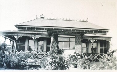
 Phillip Island and District Historical Society Inc.
Photograph, 1978/9
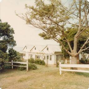
The home of Captain Loch at Rhyll was built in the 1860s from timber from deserted cottages on the Island, one of which Capt. Loch lived in when he first came to Phillip Island about 1850.Coloured photograph showing the house of Captain Lock at Rhylllocal history, photographs, buildings - historical, housing, coloured photograph, john cook, phillip island, cpt lock -
 Phillip Island and District Historical Society Inc.
Photograph, 1978/9
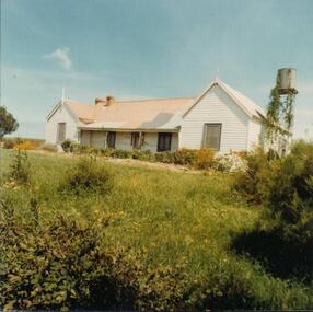
"Heath Hill" was built by the McIlwraith brothers in 1872. They were one of the early settlers on the Island.Coloured photograph showing "Heath Hill" which was the house of the McIlwraith family on the Rhyll-Newhaven Road.local history, photographs, buildings - historical, housing, coloured photograph, john cook, phillip island, mcilwraith homestead -
 Phillip Island and District Historical Society Inc.
Photograph, 1978/79
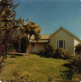
Stradbroke House was once run by W Smith - now (1979) owned by C CarterColoured photograph of Stradbroke House.local history, photographs, buildings - historical, housing, coloured photograph, john cook, phillip island, stradbroke house -
 Bendigo Historical Society Inc.
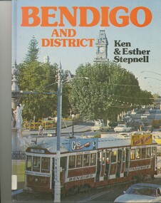
Book - BENDIGO AND DISTRICT, 1976
Bendigo & District, 32 pages with coloured photos. Includes 2 loose pages of an index of photos compiled by Lyn Friswell.Ken and Esther Stepnellbendigo, history, housing/cultural, bendigo, urban, rural, housing, history -
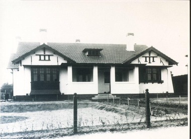
 City of Ballarat Libraries
Photograph, 208 Wendouree Parade circa 1938
Home of Mr & Mrs J.D. Smith. The house has ornamental brickwork, Iron frieze and diagonal timber balustrade posts on the vernada, slate roof and finial windows.building, private residence, house, housing, lake wendouree, wendouree parade, ballarat, j.d. smith -
 City of Ballarat Libraries
Photograph, 816 Lydiard Street North circa 1917
This residence was possibly built by Fred Duncan for John Dearden.house, housing, private residence, building, lydiard street north, ballarat, fred duncan, john dearden -
 Whitehorse Historical Society Inc.
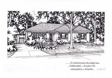
Artwork, other - Ink Line Drawing, Margaret Picken, 27 Deanswood Rd., Forest Hill, 1994
A property illustration by Margaret Picken Commissioned by the real estate agency Woodards Blackburn for the purpose of advertising 27 Deanswood Rd., Forest Hill This property is listed as having sold for $161,000 in 1994 Made by using Rotring ‘Rapidigraph’ drafting pens with Rotring ink on Rapidigraph polyester drafting film, double matte. Trained as a cartographic draftsman within the mining industry, Margaret Picken is an artist who worked producing property illustrations for real estate agencies in eastern suburbs of Victoria from 1983-2005. Retiring from the industry as technological changes favored coloured photography over illustrations, and commissioning companies over sole contractors.This artwork is of Historical Significance as a record of local domestic architecture.A black ink line drawing on drafters film by Margaret Picken, of 27 Deanswood Rd., Forest Hill. Of a one story house with a porch, steps and path leading up from the driveway on the left which leads to a detached garage in the background. A front yard with lawn, and rock edge garden beds. There are two hole punch holes along the top edge27 Deanswood Rd., Forest Hill Margaret Picken -94 Woodards B/Burnwhitehorse historical society, schwerkolt cottage, housing, architecture, margaret picken, house, garden, forest hill -
 Whitehorse Historical Society Inc.
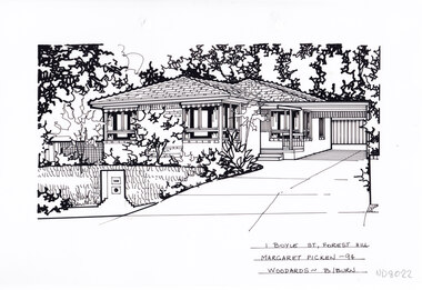
Artwork, other - Ink Line Drawing, Margaret Picken, 1 Boyle St., Forest Hill, 1994
A property illustration by Margaret Picken Commissioned by the real estate agency Woodards Blackburn for the purpose of advertising 1 Boyle St., Forest Hill This property is listed as having sold for $144,500 in 1994 Made by using Rotring ‘Rapidigraph’ drafting pens with Rotring ink on Rapidigraph polyester drafting film, double matte. Trained as a cartographic draftsman within the mining industry, Margaret Picken is an artist who worked producing property illustrations for real estate agencies in eastern suburbs of Victoria from 1983-2005. Retiring from the industry as technological changes favored coloured photography over illustrations, and commissioning companies over sole contractors.This artwork is of Historical Significance as a record of local domestic architecture.A black ink line drawing on drafters film by Margaret Picken, of 1 Boyle St., Forest Hill of a two story house with a double garage in the background. Of a driveway on the left leading to a carport, with a path leading to the entrance of a one story brick house. There are two hole punch holes along the top edge, with the punched out holes still attached.1 Boyle St., Forest Hill Margaret Picken -94 Woodards B/Burnwhitehorse historical society, schwerkolt cottage, housing, architecture, margaret picken, house, garden, forest hill -
 Whitehorse Historical Society Inc.
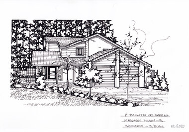
Artwork, other - Ink Line Drawing, Margaret Picken, 8 Balyarta Crt., Forest Hill, 1996
A property illustration by Margaret Picken Commissioned by the real estate agency Woodards Blackburn for the purpose of advertising 8 Balyarta Crt., Forest Hill This property is listed as having sold for $158,000 in 1996 Made by using Rotring ‘Rapidigraph’ drafting pens with Rotring ink on Rapidigraph polyester drafting film, double matte. Trained as a cartographic draftsman within the mining industry, Margaret Picken is an artist who worked producing property illustrations for real estate agencies in eastern suburbs of Victoria from 1983-2005. Retiring from the industry as technological changes favored coloured photography over illustrations, and commissioning companies over sole contractors.This artwork is of Historical Significance as a record of local domestic architecture.A black ink line drawing on drafters film by Margaret Picken, of 8 Balyarta Crt., Forest Hill Of a two story house with a double garage in the background. A landscaped front lawn in the left foreground, and a driveway leading to the the garage in the right foreground. There are 2 hole punch holes along the top edge.8 Balyarta Crt., Forest Hill Margaret Picken -96 Woodards B/Burnwhitehorse historical society, schwerkolt cottage, housing, architecture, margaret picken, house, garden, forest hill -
 Whitehorse Historical Society Inc.
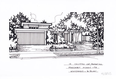
Artwork, other - Ink Line Drawing, Margaret Picken, 14 Calypso Crt., Forest Hill, 1994
A property illustration by Margaret Picken Commissioned by the real estate agency Woodards Blackburn for the purpose of advertising 14 Calypso Crt., Forest Hill This property is listed as having sold for $220,000 in 1994. Made by using Rotring ‘Rapidigraph’ drafting pens with Rotring ink on Rapidigraph polyester drafting film, double matte. Trained as a cartographic draftsman within the mining industry, Margaret Picken is an artist who worked producing property illustrations for real estate agencies in eastern suburbs of Victoria from 1983-2005. Retiring from the industry as technological changes favored coloured photography over illustrations, and commissioning companies over sole contractors.This artwork is of Historical Significance as a record of local domestic architecture.A black ink line drawing on drafters film by Margaret Picken, of 14 Calypso Crt., Forest Hill of a two story house with a double garage in the background. A flat roofed two story house with garage. On the left is the driveway, and on the right a front lawn with garden beds and trees. There are two hole punch holes along the top edge.14 Calypso Crt., Forest Hill Margaret Picken -94 Woodards - B/Burnwhitehorse historical society, schwerkolt cottage, housing, architecture, margaret picken, house, garden, forest hill -
 Whitehorse Historical Society Inc.
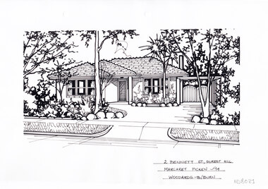
Artwork, other - Ink Line Drawing, Margaret Picken, 2 Bennett St., Forest Hill, 1994
A property illustration by Margaret Picken Commissioned by the real estate agency Woodards Blackburn for the purpose of advertising 2 Bennett St., Forest Hill This property built circa 1960's, is listed as having sold for $144,500 in 1994 Made by using Rotring ‘Rapidigraph’ drafting pens with Rotring ink on Rapidigraph polyester drafting film, double matte. Trained as a cartographic draftsman within the mining industry, Margaret Picken is an artist who worked producing property illustrations for real estate agencies in eastern suburbs of Victoria from 1983-2005. Retiring from the industry as technological changes favored coloured photography over illustrations, and commissioning companies over sole contractors.This artwork is of Historical Significance as a record of local domestic architecture.A black ink line drawing on drafters film by Margaret Picken, of 2 Bennett St., Forest Hill Of a two story house with a double garage in the background. Of a driveway on the left leading to a carport, with a path leading to the entrance of a one story brick house. There are two hole punch holes along the top edge.2 Bennett St., Forest Hill Margaret Picken -94 Woodards B/Burnwhitehorse historical society, schwerkolt cottage, housing, architecture, margaret picken, house, garden, forest hill -
 Whitehorse Historical Society Inc.
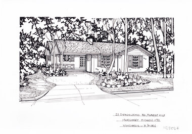
Artwork, other - Ink Line Drawing, Margaret Picken, 23 Deanswood Rd., Forest Hill, 1993
A property illustration by Margaret Picken Commissioned by the real estate agency Woodards Blackburn for the purpose of advertising 23 Deanswood Rd., Forest Hill This property is listed as having sold for $215,000 in 1993 Made by using Rotring ‘Rapidigraph’ drafting pens with Rotring ink on Rapidigraph polyester drafting film, double matte. Trained as a cartographic draftsman within the mining industry, Margaret Picken is an artist who worked producing property illustrations for real estate agencies in eastern suburbs of Victoria from 1983-2005. Retiring from the industry as technological changes favored coloured photography over illustrations, and commissioning companies over sole contractors.This artwork is of Historical Significance as a record of local domestic architecture.A black ink line drawing on drafters film by Margaret Picken, of 23 Deanswood Rd., Forest Hill. In the background a single story brick house with porch surrounded by trees, a driveway on the left leading to the house. In the foreground on the right is a front lawn with five trees. There are two hole punch holes along the top edge.23 Deanswood Rd., Forest Hill Margaret Picken -93 Woodards B/Burnwhitehorse historical society, schwerkolt cottage, housing, architecture, margaret picken, house, garden, forest hill -
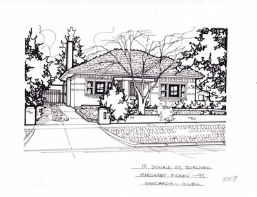
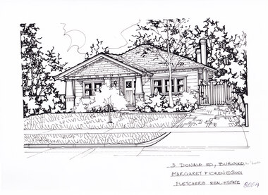 Whitehorse Historical Society Inc.
Artwork, other - Ink Line Drawing, 3 Donald Rd., Burwood, 2003
A property illustration by Margaret Picken Commissioned by the real estate agency Fletchers for the purpose of advertising 3 Donald Rd., Burwood in 2001. Made by using Rotring ‘Rapidigraph’ drafting pens with Rotring ink on Rapidigraph polyester drafting film, double matte. This property is listed as having sold for in 2001 $490,000 Trained as a cartographic draftsman within the mining industry, Margaret Picken is an artist who worked producing property illustrations for real estate agencies in eastern suburbs of Victoria from 1983-2005. Retiring from the industry as technological changes favored coloured photography over illustrations, and commissioning companies over sole contractors.This artwork is of Historical Significance as a record of local domestic architecture.A black ink line drawing on drafters film by Margaret Picken, of 3 Donald Rd., Burwood. A one story weatherboard bungalow, set back from a front lawn in foreground. There is a small tree in the center of the lawn, and a driveway on the right.3 Donald Rd., Burwood Margaret Picken © 2001 Fletchers Real Estatewhitehorse historical society, schwerkolt cottage, housing, architecture, margaret picken, burwood, house, garden -
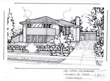 Whitehorse Historical Society Inc.
Artwork, other - Ink Line Drawing, 26 Davis St., Burwood, 2003
A property illustration by Margaret Picken Commissioned by the real estate agency Fletchers for the purpose of advertising 26 Davis St., Burwood for sale in 2003. Made by using Rotring ‘Rapidigraph’ drafting pens with Rotring ink on Rapidigraph polyester drafting film, double matte. This property is listed as having sold for in 2003 $373,000 Trained as a cartographic draftsman within the mining industry, Margaret Picken is an artist who worked producing property illustrations for real estate agencies in eastern suburbs of Victoria from 1983-2005. Retiring from the industry as technological changes favoured coloured photography over illustrations, and commissioning companies over sole contractors.This artwork is of Historical Significance as a record of local domestic architecture.A black ink line drawing on drafters film by Margaret Picken, of 26 Davis St., Burwood. Depicted is a two-story brick house situated back from a front lawn with a large tree, and a driveway on the right, leading to a garage26 Davis St., Burwood Picken © 2003 Fletcherswhitehorse historical society, schwerkolt cottage, housing, architecture, margaret picken, burwood, house, garden -
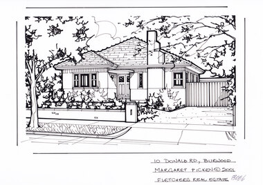 Whitehorse Historical Society Inc.
Artwork, other - Ink Line Drawing, 10 Donald Rd., Burwood, 2001
A property illustration by Margaret Picken Commissioned by the real estate agency Fletchers for the purpose of advertising 10 Donald Rd., Burwood in 2001. Made by using Rotring ‘Rapidigraph’ drafting pens with Rotring ink on Rapidigraph polyester drafting film, double matte. Trained as a cartographic draftsman within the mining industry, Margaret Picken is an artist who worked producing property illustrations for real estate agencies in eastern suburbs of Victoria from 1983-2005. Retiring from the industry as technological changes favored coloured photography over illustrations, and commissioning companies over sole contractors.This artwork is of Historical Significance as a record of local domestic architecture.A black ink line drawing on drafters film by Margaret Picken, of 6 Donald St., Burwood. A two story weatherboard house set back from a picket fence and and open gate on the right for the driveway.10 Donald Rd., Burwood Margaret Picken © 2001 Fletchers Real Estatewhitehorse historical society, schwerkolt cottage, housing, architecture, margaret picken, burwood, house, garden -
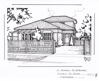 Whitehorse Historical Society Inc.
Artwork, other - Ink Line Drawing, 6 Donald Rd., Burwood, 2003
A property illustration by Margaret Picken Commissioned by the real estate agency Fletchers for the purpose of advertising 6 Donald St., Burwood in 2003. Made by using Rotring ‘Rapidigraph’ drafting pens with Rotring ink on Rapidigraph polyester drafting film, double matte. This property is listed as having sold for in 2003 $560,000 Trained as a cartographic draftsman within the mining industry, Margaret Picken is an artist who worked producing property illustrations for real estate agencies in eastern suburbs of Victoria from 1983-2005. Retiring from the industry as technological changes favored coloured photography over illustrations, and commissioning companies over sole contractors.This artwork is of Historical Significance as a record of local domestic architecture.A black ink line drawing on drafters film by Margaret Picken, of 6 Donald St., Burwood. A two story weatherboard house set back from a picket fence and and open gate on the right for the driveway.6 Donald St., Burwood Margaret Picken © 2003 Fletchers whitehorse historical society, schwerkolt cottage, housing, architecture, margaret picken, burwood, house, garden -
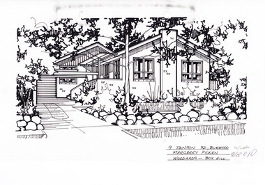 Whitehorse Historical Society Inc.
Artwork, other - Ink Line Drawing, 9 Tainton Rd., Burwood, circa 1990's
A property illustration by Margaret Picken Commissioned by the real estate agency Woodards Box Hill for the purpose of advertising 9 Tainton Rd., Burwood circa 1990's Made by using Rotring ‘Rapidigraph’ drafting pens with Rotring ink on Rapidigraph polyester drafting film, double matte. This property is listed as having had unit 10 sell for $137,000 in 1990 Trained as a cartographic draftsman within the mining industry, Margaret Picken is an artist who worked producing property illustrations for real estate agencies in eastern suburbs of Victoria from 1983-2005. Retiring from the industry as technological changes favored coloured photography over illustrations, and commissioning companies over sole contractors.This artwork is of Historical Significance as a record of local domestic architecture.A black ink line drawing on drafters film by Margaret Picken, of 9 Tainton St., Burwood. A single story brick house with multiple pitched roofs, to the left is a driveway leading to a garage in the background. and in front of the house is a lawn enclosed by a low rock fence and shrubbery. There are two hole punches near the upper edge, And a black wear mark running left below the upper edge9 Tainton Rd., Burwood Margaret Picken Woodards - Box Hillwhitehorse historical society, schwerkolt cottage, housing, architecture, margaret picken, burwood, house, garden -
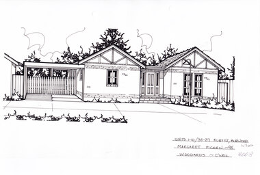 Whitehorse Historical Society Inc.
Artwork, other - Ink Line Drawing, Margaret Picken, Units 1-10/35-37 Ruby St., Burwood, 1995
A property illustration by Margaret Picken Commissioned by the real estate agency Woodards for the purpose of advertising Units 1-10/35-37 Ruby St., Burwood in 1995. Made by using Rotring ‘Rapidigraph’ drafting pens with Rotring ink on Rapidigraph polyester drafting film, double matte. This property is listed as having had unit 10 sell for $149,000 in 1995 Trained as a cartographic draftsman within the mining industry, Margaret Picken is an artist who worked producing property illustrations for real estate agencies in eastern suburbs of Victoria from 1983-2005. Retiring from the industry as technological changes favored coloured photography over illustrations, and commissioning companies over sole contractors.This artwork is of Historical Significance as a record of local domestic architecture.A black ink line drawing on drafters film by Margaret Picken, of Units 1-10/35-37 St., Burwood. a single story brick house with two pitched roofs either side of a central porch and front door. There is a connected carport on the left. There are two hole punches near the upper edge.Units 1-10/35-37 Ruby St., Burwood Margaret Picken - 95 Woodards - c'well whitehorse historical society, schwerkolt cottage, housing, architecture, margaret picken, burwood, house, garden -
 Whitehorse Historical Society Inc.
Artwork, other - Ink Line Drawing, Margaret Picken, 15 Donald St., Burwood, 1995
A property illustration by Margaret Picken Commissioned by the real estate agency Woodards Camberwell for the purpose of advertising 15 Donald St., Burwood in 1995. Made by using Rotring ‘Rapidigraph’ drafting pens with Rotring ink on Rapidigraph polyester drafting film, double matte. This property is listed as having sold for $190,00 in 1995 Trained as a cartographic draftsman within the mining industry, Margaret Picken is an artist who worked producing property illustrations for real estate agencies in eastern suburbs of Victoria from 1983-2005. Retiring from the industry as technological changes favored coloured photography over illustrations, and commissioning companies over sole contractors.This artwork is of Historical Significance as a record of local domestic architecture.A black ink line drawing on drafters film by Margaret Picken, of 15 Donald St., Burwood. A two story weatherboard house set back from a picket fence and and open gate on the right for the driveway. There are two hole punches near the upper edge.15 Donald St., Burwood Margaret Picken - 95 Woodards - c'well whitehorse historical society, schwerkolt cottage, housing, architecture, margaret picken, burwood, house, garden -
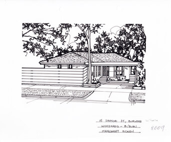 Whitehorse Historical Society Inc.
Artwork, other - Ink Line Drawing, 15 Satori St., Burwood, circa 1983-2005
A property illustration by Margaret Picken Commissioned by the real estate agency Woodards for the purpose of advertising 15 Satori St., Burwood Made by using Rotring ‘Rapidigraph’ drafting pens with Rotring ink on Rapidigraph polyester drafting film, double matte. Trained as a cartographic draftsman within the mining industry, Margaret Picken is an artist who worked producing property illustrations for real estate agencies in eastern suburbs of Victoria from 1983-2005. Retiring from the industry as technological changes favored coloured photography over illustrations, and commissioning companies over sole contractors.This artwork is of Historical Significance as a record of local domestic architecture.A black ink line drawing on drafters film by Margaret Picken, of 15 Satori St., Burwood. A single story brick house, with a driveway on the left leading to a connected carport which covers the front door. in the foreground is a horizontal plank timber fence, and a tall gumtree.15 Satori St., Burwood Woodards - B.Burn Margaret Pickenwhitehorse historical society, schwerkolt cottage, housing, architecture, margaret picken, burwood, house, garden -
 Whitehorse Historical Society Inc.
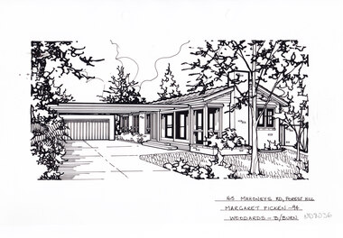
Artwork, other - Ink Line Drawing, Margaret Picken, 165 Mahoneys Rd., Forest Hill, 1994
A property illustration by Margaret Picken Commissioned by the real estate agency Woodards Blackburn for the purpose of advertising 96 Mahoneys Rd., Forest Hill. This property is listed as having sold for $142,500 in 1994. Made by using Rotring ‘Rapidigraph’ drafting pens with Rotring ink on Rapidigraph polyester drafting film, double matte. Trained as a cartographic draftsman within the mining industry, Margaret Picken is an artist who worked producing property illustrations for real estate agencies in eastern suburbs of Victoria from 1983-2005. Retiring from the industry as technological changes favored coloured photography over illustrations, and commissioning companies over sole contractors.This artwork is of Historical Significance as a record of local domestic architecture.A black ink line drawing on drafters film by Margaret Picken, of 165 Mahoneys Rd., Forest Hill, a brick path leading to a flat roofed single story house set back from a lawn and garden in the foreground. There are two hole punch holes centre near the upper edge. There are smudges near the top left corner of the artwork. There are light linear marks on near the centre right border. 165 Mahoneys Rd., Forest Hill Margaret Picken -94 Woodards - B/Burnwhitehorse historical society, schwerkolt cottage, housing, architecture, margaret picken, house, garden, forest hill -
 Whitehorse Historical Society Inc.
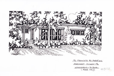
Artwork, other - Ink Line Drawing, Margaret Picken, 96 Mahoneys Rd., Forest Hill, 1997
A property illustration by Margaret Picken Commissioned by the real estate agency Woodards Blackburn for the purpose of advertising 96 Mahoneys Rd., Forest Hill. This property is listed as having sold for $170,000 in 1996. Made by using Rotring ‘Rapidigraph’ drafting pens with Rotring ink on Rapidigraph polyester drafting film, double matte. Trained as a cartographic draftsman within the mining industry, Margaret Picken is an artist who worked producing property illustrations for real estate agencies in eastern suburbs of Victoria from 1983-2005. Retiring from the industry as technological changes favored coloured photography over illustrations, and commissioning companies over sole contractors.This artwork is of Historical Significance as a record of local domestic architecture.A black ink line drawing on drafters film by Margaret Picken, of 96 Mahoneys Rd., Forest Hill, featuring a brick path leading to a flat roofed single story house set back from a lawn and garden in the foreground. There are two hole punch holes centre near the upper edge. There is a 1x1.5 dried and discoloured adhesive mark 53 Jolimont Rd., Forest Hill Margaret Picken -96 Woodards - Box Hillwhitehorse historical society, schwerkolt cottage, housing, architecture, margaret picken, house, garden, forest hill -
 Whitehorse Historical Society Inc.
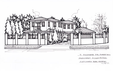
Artwork, other - Ink Line Drawing, Margaret Picken, 9 Panorama Dve., Forest Hill, 2001
A property illustration by Margaret Picken Commissioned by the real estate agency Fletchers for the purpose of advertising 9 Panorama Dve., Forest Hill. This property is listed as having sold for $525,000 in 2001. Made by using Rotring ‘Rapidigraph’ drafting pens with Rotring ink on Rapidigraph polyester drafting film, double matte. Trained as a cartographic draftsman within the mining industry, Margaret Picken is an artist who worked producing property illustrations for real estate agencies in eastern suburbs of Victoria from 1983-2005. Retiring from the industry as technological changes favored coloured photography over illustrations, and commissioning companies over sole contractors.This artwork is of Historical Significance as a record of local domestic architecture.A black ink line drawing on drafters film by Margaret Picken, of 9 Panorama Dve., Forest Hill, of a two story rendered house set back from a high wrought iron and render fence, with driveway on the right leading to a connected garage.9 Panorama Dve., Forest Hill Margaret Picken © 2001 Fletchers Real Estatewhitehorse historical society, schwerkolt cottage, housing, architecture, margaret picken, house, garden, forest hill -
 Whitehorse Historical Society Inc.
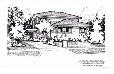
Artwork, other - Ink Line Drawing, Margaret Picken, 4 Pilita St., Forest Hill, 1990
A property illustration by Margaret Picken Commissioned by the real estate agency Woodards Box Hill for the purpose of advertising 4 Pilita St., Forest Hill. Made by using Rotring ‘Rapidigraph’ drafting pens with Rotring ink on Rapidigraph polyester drafting film, double matte. Trained as a cartographic draftsman within the mining industry, Margaret Picken is an artist who worked producing property illustrations for real estate agencies in eastern suburbs of Victoria from 1983-2005. Retiring from the industry as technological changes favored coloured photography over illustrations, and commissioning companies over sole contractors.This artwork is of Historical Significance as a record of local domestic architecture.A black ink line drawing on drafters film by Margaret Picken, of 4 Pilita St., Forest Hill, a two story brick and weather board house set back from a front lawn, with a driveway leading to a connected carport. There are two hole punches centre of the upper edge4 Pilita St., Forest Hill Margaret Picken '90 Woodards - Box Hillwhitehorse historical society, schwerkolt cottage, housing, architecture, margaret picken, house, garden, forest hill -
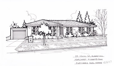 Whitehorse Historical Society Inc.
Artwork, other - Ink Line Drawing, Margaret Picken, 23 Mock St., Forest Hill, 2001
A property illustration by Margaret Picken Commissioned by the real estate agency Fletchers Real Estate for the purpose of advertising 23 Mock St., Forest Hill. Made by using Rotring ‘Rapidigraph’ drafting pens with Rotring ink on Rapidigraph polyester drafting film, double matte. Trained as a cartographic draftsman within the mining industry, Margaret Picken is an artist who worked producing property illustrations for real estate agencies in eastern suburbs of Victoria from 1983-2005. Retiring from the industry as technological changes favored coloured photography over illustrations, and commissioning companies over sole contractors.This artwork is of Historical Significance as a record of local domestic architecture.A black ink line drawing on drafters film by Margaret Picken, of 23 Mock St., Forest Hill, of a brick single story house set back from a front lawn with driveway leading to a garage on the left.23 Mock St., Forest Hill Margaret Picken © 2001 Fletchers Real Estatewhitehorse historical society, schwerkolt cottage, housing, architecture, margaret picken, house, garden, forest hill -
 Whitehorse Historical Society Inc.
Artwork, other - Ink Line Drawing, 26 Highview Gve., Burwood E, 1994
A property illustration by Margaret Picken Commissioned by the real estate agency Fletchers Real Estate for the purpose of advertising 26 Highview Gve., Burwood in 1994 Made by using Rotring ‘Rapidigraph’ drafting pens with Rotring ink on Rapidigraph polyester drafting film, double matte. This property is listed as having sold for $160,250 in 1994 Since being sold the land has been redeveloped, with nothing remaining of the house depicted in this drawing. Trained as a cartographic draftsman within the mining industry, Margaret Picken is an artist who worked producing property illustrations for real estate agencies in eastern suburbs of Victoria from 1983-2005. Retiring from the industry as technological changes favored coloured photography over illustrations, and commissioning companies over sole contractors.This artwork is of Historical Significance as a record of local domestic architecture.A black ink line drawing on drafters film by Margaret Picken, of 26 Highview Gve., Burwood East. An angled birds eye view from the street of a weatherboard house and carport. Extending to the backyards with pool, pagoda, and shed in the background. There are two hole punch holes on near the left edge. There are some crinkles in the paper near the top centre of the work. There is a two centimetre long mark along the centre top edge.26 Highview Gve., Burwood E Margaret Picken -94 Woodards B/Burnwhitehorse historical society, schwerkolt cottage, housing, architecture, margaret picken, burwood, house, garden -
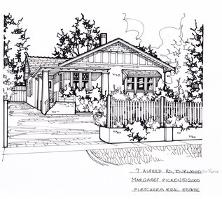 Whitehorse Historical Society Inc.
Artwork, other - Ink Line Drawing, 7 Alfred Rd., Burwood, circa 1990's
A property illustration by Margaret Picken Commissioned by the real estate agency Fletchers Real Estate for the purpose of advertising 7 Alfred Rd, Burwood in 2000 Made by using Rotring ‘Rapidigraph’ drafting pens with Rotring ink on Rapidigraph polyester drafting film, double matte. This property is listed as having had unit 10 sell for $404,000 in 2000 Trained as a cartographic draftsman within the mining industry, Margaret Picken is an artist who worked producing property illustrations for real estate agencies in eastern suburbs of Victoria from 1983-2005. Retiring from the industry as technological changes favored coloured photography over illustrations, and commissioning companies over sole contractors.This artwork is of Historical Significance as a record of local domestic architecture.A black ink line drawing on drafters film by Margaret Picken, of 9 Tainton St., Burwood. A single story brick bungalow, with roofed porch wrapping around the font left corner of the house. A Picket and brick fence borders the front yard, and opens to a brick driveway on the left. Shrubbery growing in front of house and along the fence.7 Alfred Rd., Burwood Margaret Picken © 2000 Fletchers Real Estatewhitehorse historical society, schwerkolt cottage, housing, architecture, margaret picken, burwood, house, garden -
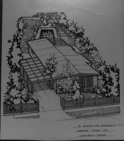
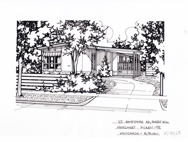 Whitehorse Historical Society Inc.
Artwork, other - Ink Line Drawing, Margaret Picken, 25 Hampshire Rd., Forest Hill, 1995
A property illustration by Margaret Picken Commissioned by the real estate agency Woodards Blackburn for the purpose of advertising 25 Hampshire Rd., Forest Hill. This property is listed as having sold for $104,000 in 1996. Since the time of sale in 1996 the house on the property has been demolished and a new house built on the site. Made by using Rotring ‘Rapidigraph’ drafting pens with Rotring ink on Rapidigraph polyester drafting film, double matte. Trained as a cartographic draftsman within the mining industry, Margaret Picken is an artist who worked producing property illustrations for real estate agencies in eastern suburbs of Victoria from 1983-2005. Retiring from the industry as technological changes favored coloured photography over illustrations, and commissioning companies over sole contractors.This artwork is of Historical Significance as a record of local domestic architecture.A black ink line drawing on drafters film by Margaret Picken, of 25 Hampshire Rd., Forest Hill. Depicting in the foreground a horizontal timber plank fence on the left, and a curving driveway on the right leading to a connected carport. In the background is a small house. There are two hole punch holes just right of centre on the upper edge. There is a 0.5x0.5 mark on the top half of the right edge25 Hampshire Rd., Forest Hill Margaret Picken - 95 Woodards B/Burnwhitehorse historical society, schwerkolt cottage, housing, architecture, margaret picken, house, garden, forest hill -
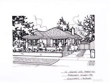 Whitehorse Historical Society Inc.
Artwork, other - Ink Line Drawing, Margaret Picken, 14 Jaques Grv., Forest Hill, 1993
A property illustration by Margaret Picken Commissioned by the real estate agency Woodards Blackburn for the purpose of advertising 14 Jaques GVE., Forest Hill, This property is listed as having sold for $157,000 in 1993. The house depicted in this artwork is no longer standing. Having been demolished and a new house built in its place between the time of this artworks creation in 1993 and 2024. Made by using Rotring ‘Rapidigraph’ drafting pens with Rotring ink on Rapidigraph polyester drafting film, double matte. Trained as a cartographic draftsman within the mining industry, Margaret Picken is an artist who worked producing property illustrations for real estate agencies in eastern suburbs of Victoria from 1983-2005. Retiring from the industry as technological changes favored coloured photography over illustrations, and commissioning companies over sole contractors.This artwork is of Historical Significance as a record of local domestic architecture.A black ink line drawing on drafters film by Margaret Picken, of 14 Jaques Grv., Forest Hill, depicting a single story brick house set back from a low fence and front yard, with a driveway on the right. There are two hole punch holes centre near the upper edge.14 Jaques Grv., Forest Hill Margaret Picken- 93 Woodards - B/Burnwhitehorse historical society, schwerkolt cottage, housing, architecture, margaret picken, house, garden, forest hill -
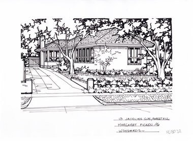 Whitehorse Historical Society Inc.
Artwork, other - Ink Line Drawing, Margaret Picken, 13 Jaques gve., Forest Hill, 1996
A property illustration by Margaret Picken Commissioned by the real estate agency Woodards Blackburn for the purpose of advertising 13 Jaques GVE., Forest Hill, This property is listed as having sold for $130,000 in 1996. Made by using Rotring ‘Rapidigraph’ drafting pens with Rotring ink on Rapidigraph polyester drafting film, double matte. Trained as a cartographic draftsman within the mining industry, Margaret Picken is an artist who worked producing property illustrations for real estate agencies in eastern suburbs of Victoria from 1983-2005. Retiring from the industry as technological changes favored coloured photography over illustrations, and commissioning companies over sole contractors.This artwork is of Historical Significance as a record of local domestic architecture.A black ink line drawing on drafters film by Margaret Picken, of 16 Jackson St., Forest Hill, depicting a single story brick house, with driveway leading to a connected carport on the left. In the foreground, a low brick fence and front lawn. There are two hole punch holes centre near the upper edge.16 Jackson St., Forest Hill Margaret Picken © 2003 Realtorwhitehorse historical society, schwerkolt cottage, housing, architecture, margaret picken, house, garden, forest hill