Showing 902 items
matching land subdivisions
-
 Ringwood and District Historical Society
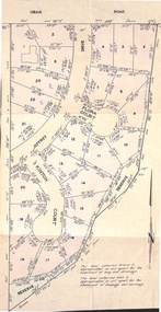
Document - Folder, Kinton Court Estate Subdivision, Ringwood, Victoria - 1975
Manilla folder containing plan of residential subdivision, with price list and summary of services available. Subdivision includes Oban Road, Jeffrey Drive, Flora Court and Kinton Court. Timbered land - 22 sewered allotments. Agents - C.E. Carter & Son RESI., 122 Whitehorse Road, Ringwood (Phone) 8706211. -
 Warrnambool and District Historical Society Inc.
Document - Warrnambool City Council Preliminary Report Industrial Estate West Warrnambool, E Johnson, 9 March 1973
This preliminary report relates to 32½ acres of council owned land in West Warrnambool bounded on the North by McMeekin Road, on the East by Scott Street, on the South by Evans Street and on the West by the rear boundaries of properties facing Landmann and Granter Streets. In 2010, West Warrnambool was the largest of Warrnambool’s existing industrial areas, comprising approximately 109ha of industrial zoned land, the majority of which (101ha) is zoned IN1Z, with the remainder zoned INZ3. The area comprises a mixture of lot sizes supporting a diverse mix of industries. Larger parcels are occupied by the abattoirs, scrap metal industries, freight, the Council Depot and storage. Smaller lots are occupied by smaller manufacturers and wholesalers and service industries. [Ref: Warrnambool Industrial Land Use Review. Mesh Pty Ltd July 2010]This document is a preliminary report prepared by the Warrnambool City Council Engineer in March 1973 and provides an example of the planning process undertaken to develop one of Warrnambool's industrial areas. It contains details and costings of the proposed subdivision. Two foolscaps size pages of typewritten information. A detailed topographical map of the area with areas highlighted in blue, red, green, blue and purple pen.warrnambool city council, west warrnambool, industrial estate -
 Eltham District Historical Society Inc
Photograph - Digital Photograph, Alan King, Edendale Farm Homestead, 29 January 2008
... Holloway's Little Eltham subdivision. Despite clearing the land... Holloway's Little Eltham subdivision. Despite clearing the land ...Edendale Farm is Nillumbik Shire Council's environment centre situated in Gastons Road, Eltham between the railway and the Diamond Creek. The homestead on the property was built in 1896 and is of historical significance, being the subject of a Heritage Overlay under the Nillumbik Planning Scheme. The Edendale property was originally part of an extensive land purchase in 1852 from the Crown by pioneer Eltham farmer Henry Stooke. He initially purchased 51 acres and later expanded his holdings by purchasing another three adjacent Crown allotments extending northerly from Josiah Holloway's Little Eltham subdivision. Despite clearing the land, Stooke did not build on this property, choosing to live on his property "Rosehill" at Lower Plenty. In 1896 Thomas Cool, Club Manager of the Victoria Coffee Palace in Melbourne purchased 7 acres of the original Stooke land and built the house now known as Edendale. Cool did not farm the land, instead using it as a gentleman’s residence, retiring to Eltham at weekends. In 1918 he purchased an additional 7 acres but in 1919 he sold the property. Later owners included J.W. Cox, the Gaston family and D. Mummery. In the 1980s the Eltham Shire Council purchased the site for use as a Council depot, but this use did not proceed. Subsequently, it was used as the Council pound. The Edendale Farm Pet Education and Retention Centre was established in the summer of 1988/1989 and was set up to replace the existing dog kennels with a high standard pet retention centre. The design style of the building was established to compliment the features of the existing house. It was equipped with 10 retention pens, a veterinary room and a pet education area where school children and other interested parties learnt about pet care procedures. It was later developed into a community farm and was run by an advisory committee and in 2000 it became an Environment Centre. In early 2006 an advisory committee was established for the development of a master plan for future development at Edendale Farm. The committee included Russell Yeoman, a former long-time shire planner and founding member of the Eltham District Historical Society. At the time of filming the Master Plan and future for Edendale was about continuing to develop Edendale as a centre of environment learning and looking at expanding displays and school program, running a lot more of life-long learning and workshops around sustainable living. Covered under Heritage Overlay, Nillumbik Planning Scheme. Published: Nillumbik Now and Then / Marguerite Marshall 2008; photographs Alan King with Marguerite Marshall.; p101 A sharp turn from busy Wattletree Road by the railway line, brings a surprise. Only 1.4 km from Eltham’s centre, sheep feed, blissfully unaware of the hectic suburban activity so close by. At the entrance to the 5.6ha Edendale Farm is another surprise. A work of art that looks like huge tree trunks transformed into bowler and top-hatted men. The Fences Act 1968 by Tony Trembath with Mark Cain and John Doyle, 1996, is classified by the National Trust of Australia as having Regional Significance. The title refers to a government act on disputes between neighbors over the placement of fences and boundaries. This takes a ‘wry swipe’ at a community divided by trivial squabbles. It also celebrates making do with limited resources.1 Further along on the left, the office wall is decorated with a massive Eltham Copper Butterfly, designed by Robert Tickner and made by school children with used plastic bottles and other waste material. Nillumbik Council runs Edendale as an Environmental Education Centre, to help preserve and enhance the local environment. As early as 1988 the former Eltham Shire Council realised Edendale’s importance in meeting people’s needs, particularly of children, to enjoy farmland. The centre, with the Eltham North Reserve to the north - including remnant bushland and open parkland - makes up the major part of the public open space for this area. The council considers this area will become increasingly important to the local community for recreational use.2 Educational programs aim to encourage community involvement to ensure the long-term rehabilitation and protection of natural bushland areas. Edendale is used by people of all ages - from school children to adults - for environmental programs and workshops, as well as for recreation, to enjoy the domestic animals and to picnic. Edendale is also home to the Environmental Works staff who manage reserves and roadsides and support Nillumbik Friends environmental groups. The Friends propagate plants at the nursery, which grows indigenous plants and sells these to the public.3 The centre demonstrates the sustainable living the farm teaches, with features like solar hot water and drive lighting and for the fireplace, logs of recycled cardboard. Edendale has had a varied history as a dog pound and even as a retreat for Thomas Cool, Club Manager of the Victoria Coffee Palace in Melbourne. His single-storey weatherboard house built in 1896, which still stands, was grander than most homes in Eltham. Although such buildings were common in many other parts of Melbourne, Eltham’s poverty and remoteness did not encourage such construction. The Victorian rectangular-shaped house, with a corrugated iron roof and veranda, has elegant large rooms, leadlight windows, ceiling roses, two bay windows and ornately carved wooden fireplace surrounds. Cool bought seven acres (2.8ha) from pioneer Eltham farmer Henry Stooke’s 200 acre (81ha) farm, which he had bought from the Crown in 1852. In 1918 Cool bought an extra seven acres (2.8ha) but in 1919 sold the estate to farmer John Cox. In 1933 Cox sold Edendale to Mrs Elizabeth Gaston, after whom the road leading to the centre was named. The property was owned by several Gaston family members, who called it Edendale, then by a police constable, Douglas Mummery, until the Shire of Eltham bought it in 1970. Oddly Edendale was known as Mummery’s for almost 20 years, although Mummery owned it only for a short time.4 The shire used Edendale as a dog pound until amalgamation with other municipalities in 1996. The pound then moved to the Yan Yean Road, Plenty site, which had been used by the former Diamond Valley Shire Council. To the west and north the centre is bounded by Diamond Creek and on the east by the Melbourne-Hurstbridge railway line. Part of the Research creek forms the centre’s southern boundary.This collection of almost 130 photos about places and people within the Shire of Nillumbik, an urban and rural municipality in Melbourne's north, contributes to an understanding of the history of the Shire. Published in 2008 immediately prior to the Black Saturday bushfires of February 7, 2009, it documents sites that were impacted, and in some cases destroyed by the fires. It includes photographs taken especially for the publication, creating a unique time capsule representing the Shire in the early 21st century. It remains the most recent comprehenesive publication devoted to the Shire's history connecting local residents to the past. nillumbik now and then (marshall-king) collection, edendale farm -
 Eltham District Historical Society Inc
Photograph - Digital Photograph, Alan King, Original Kangaroo Ground Primary School No. 2105 building, Eltham-Yarra Glen Road, Kangaroo Ground, 28 December 2007
Kangaroo Ground's first school began in 1851 with 22 pupils from the district's ten families. It was a single room school located further south on the site, which also served as a Presbyterian church. The first teacher was Andrew Ross. The school building was used as a Post Office between 1854 and 1858 and during 1857 also served as a Court of Petty Sessions. With a growing farming community, a new building was warranted and the original Sate School No. 352 was closed and a new building, State School No. 2105 was oipened October 1, 1878. A residence for Head Teacher Henry Wallace School was erected in 1879 attached to the left of the school building. That residence is now home to the Andrew Ross Museum, which opened in 1993. Covered under Heritage Overlay, Nillumbik Planning Scheme. Published: Nillumbik Now and Then / Marguerite Marshall 2008; photographs Alan King with Marguerite Marshall.; p35 In a corner of the Kangaroo Ground Primary School playground stands an old weatherboard building. This structure, attached to the former teacher’s weatherboard residence facing Main Road, first served as a school in 1878. The former residence, built in 1879, houses the Andrew Ross Museum, which opened in 1993. It is named after the school’s first teacher,1 who also founded The Evelyn Observer newspaper, which began on the site in 1873. Later the printing presses were moved to brick newspaper offices by the Kangaroo Ground Hotel, which became the Shire of Eltham offices. However Kangaroo Ground’s first school began in 1851 for 22 pupils from the district’s ten families, in a slab building further south on this site. Andrew Harkness and other settlers campaigned for the building, which was built on half an acre (0.2ha) donated by local farmer, James Donaldson. Builder was Samuel Furphy, father of the novelist Joseph.2 The single room measuring 30 feet x 18 feet (9m x 5.5m), was unlined and the green slabs shrank, allowing the wind and rain entry through cracks except when they were stuffed with paper.3 The building served as a Presbyterian church as well as a school, where fees were 18 pence a week for education. Young men also attended evening classes there in winter. At one stage, a corner of the room was curtained off for the schoolmaster’s living space, and the platform, which was used for sleeping, was also the pulpit during church services. Teacher Andrew Ross also took church services when the minister was unable to attend, which happened frequently as he had long distances to travel on the bad roads. In 1857 the school building was also used as the Court of Petty Sessions, and from 1854 until 1858, it served as a post office. During the gold rush fossickers on their way to the Caledonia Diggings at Queenstown (now St Andrews) prospected the district, but did not remain long, as the fields were not rich in gold. But the farming community grew, until by 1878 the population warranted the building of State School No 2105 – the present one-roomed tongue-and-groove lined building measuring 49 feet x 18 feet (15m x 5.5m), to accommodate 60 children. The old school, No 352, was closed, and the new one opened on October 1, with Henry Wallace as head teacher, assisted by work mistress Annie Johnston. Early teachers included Messrs Smith, Hamilton and Prosser, with sewing teachers Misses Sweeney, Limerock and Oliver. In the early 1920s a small room was built on the front veranda of the teacher’s residence, and used as a State Savings Bank agency until about 1934. In 1928 the schoolroom’s three-tiered floor was replaced by a flat floor and teacher’s platform (which has since been removed). A half-glassed partition wall then divided the large room into two rooms in which the old style form-type desks were replaced with dual desks. The small playground, surrounded by pine trees and a picket fence, was extended in 1931 with an additional acre or so (0.4 ha) of land. During World War Two the school faced closure because of a fall to seven in the enrolment, but by 1946 it had increased again to 45. Mr Eric Morgan was head teacher and Mrs Margaret Banks was assistant head teacher, a position she held for ten years. In 1955, under the head teacher Mr V Gardiner, who taught there for 13 years, the school won a prize for the best-kept garden and school ground in the inspectorate. A district subdivision increased the enrolment in 1968 to 65 and a bus service was established. After the hall which had been used for lessons was demolished late that year, the pupils met in the original fire brigade meeting room (now the tennis club, diagonally opposite the general store). The new school building with a storeroom and staffroom was built in 1974.This collection of almost 130 photos about places and people within the Shire of Nillumbik, an urban and rural municipality in Melbourne's north, contributes to an understanding of the history of the Shire. Published in 2008 immediately prior to the Black Saturday bushfires of February 7, 2009, it documents sites that were impacted, and in some cases destroyed by the fires. It includes photographs taken especially for the publication, creating a unique time capsule representing the Shire in the early 21st century. It remains the most recent comprehenesive publication devoted to the Shire's history connecting local residents to the past. nillumbik now and then (marshall-king) collection, kangaroo ground, andrew ross museum, eltham-yarra glen road, kangaroo ground primary school no. 2105, kangaroo ground state school, state school no. 2105 -
 Ringwood and District Historical Society
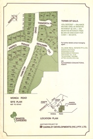
Flyer, Land Sale Advertisement - Banool Gardens Subdivision, Ringwood, Vic. c.1985
Double-sided advertisement for Banool Gardens subdivision with site plan, location plan, terms of sale, and summary of homesite features and local services & facilities. Subdivision includes Wonga Road, Hamilton Drive, Tinworth Place, Andrea Parade and Benjamin Court, Ringwood North. Managing agent - Ollson Real Estate Pty. Ltd., North Croydon Shopping Plaza, Maroondah Highway. Croydon, Vic. 3136. Telephone 726 9988 After Hours 876 4190. Project by Darnley Developments (Vic.) Pty. Ltd. Accompanying handwritten notation by Richard Carter R.E.S.I. - "Part of original Banool property (Mahon, sold to Stallman, sold to McMahon, sold to Len Macley etc etc). Hamilton Drive named after Lynn Hamilton McMahon, Tinworth Place after his son-in-law, David Tinworth". -
 Ringwood and District Historical Society
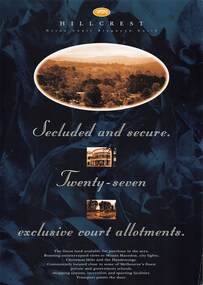
Flyer, Land Sale Advertisement, Hillcrest Heron Court, Ringwood North, Vic. - c.1994
Double sided A4 gloss print advertisement with subdivision map showing location and size of 27 residential allotments and A4 price list page for 14 Lots.Price list includes comment that "construction shall commence in September, with completion in December. Titles Office registration would be expected in January. (No mention of year/s, circa early to mid 1990s). -
 Ringwood and District Historical Society
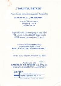
Flyer, Land Auction Advertisement, Talinga Estate, Allens Road, Heathmont, Vic. - 1985
Double sided A4 page with subdivision map showing location and size of allotments for auction on Saturday 3rd August (1985). Agent - C.E. Carter & Son Pty. Ltd., 122 Whitehorse Road, Ringwood 3134, Telephone 870 6211.Handwritten sale price annotations - Lot 1 Sold $42,000, Lot 2 Sold $42,200, Lot 3 Sold $41,500, Lot 4 Sold $53,000. -
 Ringwood and District Historical Society
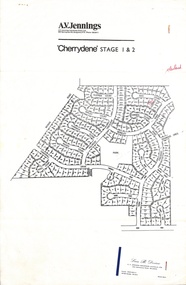
Flyer, Land Sale Advertisement - Cherrydene Estate, Stage 1 & 2, Ringwood, Vic. - 1969
Subdivison map of Cherrydene Estate and double-sided A4 size House & Land price list dated 27/10/1969. Developer - A.V. Jennings Industries (Aust) Ltd., Cnr. Springvale & Wellington Rds., Mulgrave, Vic. Phone 560 8411. Sales Dept. Rep., Leon B. Devine, Phone 560 8411 A/H.435 5311. Subdivision includes Wonga Road, Holyrood Crescent, Clipper Court, Ripley Court, Harwick Close, Bader Court, Towerhill Drive, Nigel Court, Berkley Road, Avis Court, Carmen Close, Frederic Drive, Kenwood Crescent, Adele Court, Marilyn Street, Abbey Court, Baron Court, Kismet Close, Oban Road, Ringwood.Furnished and landscaped display homes are open for your inspection, (see map on reverse side) from 11 a.m. to 5 p.m. Sundays and Holidays, and 2 p.m. to 5 p.m. weekdays and Saturdays. Display homes list for 'Cherrydene' Ringwood - Arundel, Ashmoor, Avalon, Cleveland, Chiltern, Dorset. -
 Ringwood and District Historical Society
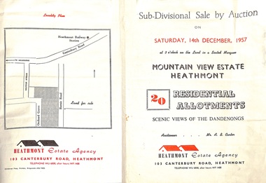
Flyer - Land Sales Brochure, Sub-Divisional Sale by Auction - Mountain View Estate, Heathmont, Victoria - 1957
Bi-fold pamphlet advertising auction of 20 residential allotments on Saturday, 14th December, 1957, with description of services available and finance terms. Subdivision inclues Orchard Grove and Barnic Road. Agent - Heathmont Estate Agency, 103 Canterbury Road, Heathmont, Telephone WU6808, after hours WF1488. Auctioneer Mr. A.B. Carter. Accompanying Parish of Ringwood survey map with cardboard backing - Part of Crown Allotment 14B, includes handwritten price notations for each allotment. -
 Ringwood and District Historical Society
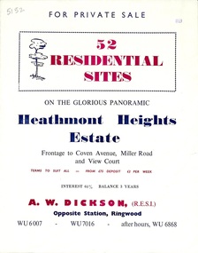
Flyer, Land Sale Brochure, Heathmont Heights Estate, Heathmont, Vic. - 1959
Bi-fold advertisement for sale of residential sites, including map and summary of subdivision features and local facilities. Subdivision includes Coven Avenue, View Court, and Miller Road. Agent - A.W. Dickson, Opposite Station. (Phone) WU6007, WU7016, after hours WU6868. Accompanying Titles Office Plan of Subdivision photocopy dated 1971 - Part of Crown Allotment 38A Parish of Ringwood. -
 Ringwood and District Historical Society
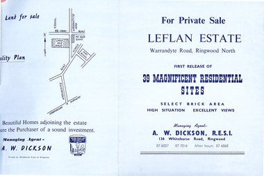
Document - Folder, Land Sale - Leflan Estate, North Ringwood, Vic. - circa 1967
Bi-fold land sale advertisements for stages 1 and 3 releases of residential allotments in Leflan Estate, Ringwood North, circa 1965-1967. Brochures include area map, layout of the estate, and summary of local facilities and services, with separate attachment listing lot number prices for 2nd and 3rd releases.Subdivision includes Melview Drive, Leslie Grove, Leflan Close, Warrandyte Road and Lockhart Street. Agent - A.W. Dickson, R.E.S.I., 136 Whitehorse Road, Ringwood. (Phone) 870-6007, 870-7016, After hours 870-6868. -
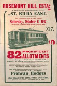 Melbourne Tram Museum
Ephemera - Real estate sale, Prahran Hodges, "Rosemont Hill Estate", Oct. 1917
Pamphlet advertising the sale of land at the "Rosemont Hill Estate", Balaclava Road, St Kilda East, 6-10-1917. On the front cover has a photo of PMTT tram No. 27. Gives terms of sale, the plan of the subdivision, and a general locality plan showing tram and rail lines. Land prices have been written in for some blocks on the pamphlet. Demonstrates the style of land sale pamphlet including the availability of tram services to prospective purchasers.Pamphlet - folded - printed in two colours of cream coloured paper with photographs and plans.has pencil notes re sale price and notes for some blocks.sale of land, trams, real estate, balaclava road, st kilda east, pmtt, tram 27, rosemont hill estate -
 Eltham District Historical Society Inc
Document, Declaration of Trustees, Eltham Public Hall, Lot 20 Henry Street, Eltham, 18 Mar 1927
Robert David Taylor of Eltham declared he was the Secretary of a certain Friendly Society known as the Hope of Eltham Tent No. 195 Victoria District of the Independent Order of Rechabites; that William John Taylor the Younger, George Knapman and Isaac Hill junior the Purchasers mentioned and described in a certain Indenture of Conveyance from Barnabas Shaw Walker and others also therein described registered in the office of the Registrar General were at the time of the registration of the said Conveyance the trustees of the said Friendly Society and purchased the land and hereditaments described in the Conveyance as such Trustees; and that Edward Samuel McColl, Jack Alfred Harrison and William Wilson were on 31 December 1926 the trustees of the said Friendly Society and as such were entitled to grant and convey the land and hereditaments described in the said Indenture of Conveyance. Originally purchased in 1856 from Thomas Roberts, Yeoman of Little Eltham, for £10 for use by the Wesleyan Chapel, represented by indentured Trustees, Rev. Barnabas Shaw Walker, Minister of the Pentridge Circuit, Francis Thomas, Farmer of Keelbundora, William Harriman, Blacksmith of Nillumbik, Nicholas Rodda, Farmer of Nillumbik, Aaron Grimshaw, Farmer of Greensborough, Joseph Cooper, Gardener of Keelbundora, Peter Dredge, Scholmaster of Jika Jika and Samuel Jeffrey, Farmer of Jika Jika. Lot 20 of Subdivision of Portion 13, Section 4 of the Parish of Nillumbik in the County of Evelyn was located on the southern side of Henry street in Little Eltham North, where the current Our Lady Help of Christians Catholic Church is situated. It became the location of the Eltham Rechabite Hall. In 1893 a new hall was built and further enlarged in 1919. At the commencement of 1922, the property was purchased from the Independent Order of Rechabites with publicly subscribed funds and a new hall built at a cost of £750 and improved road access constructed to reduce the grade, running from Dudley Street to Henry Street. This hall was eventually replaced with the new Shire Offices and Hall built on the corner of Arthur Street and Main Road, which was opened in 1941. Traces the earliest history of the Eltham Public Hall in Henry Street and the various names, occupations and abodes of the Trustees associated with the propertyedward samuel mccoll, eltham public hall, eltham rechabite hall, eltham wesleyan chapel, george knapman, henry street, hope of eltham tent no. 195, isaac hill junior, jack alfred harrison, trustee, victoria district independent order of rechabites, william john taylor the younger, william wilson -
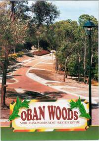 Ringwood and District Historical Society
Document - Land Sale Folder, Oban Woods Subdivision, Ringwood North, Vic., - circa 1997
Folder containing multi-fold colour pamphlet advertising Lots 6 to 12 of Oban Woods Estate with location map and summary of subdivision features. A4 size attachments include subdivision layout of Lots 2 to 25 with summary of property sizes and undated indications of whether sold or still available at the time, with price where known. Dates not documented however early sales within the development took place around 1997.Estate plan includes Oban Woods (thoroughfare) and Chifley Parade. Location map of area shows development site of Oban Woods Estate off Oban Road and Kubis Drive, Ringwood North. Agents - R.E. Appleby Ringwood Pty Ltd., 170 Warrandyte Road Ringwood North 3134, Telephone 9876 4222, Fax 9876 4209. -
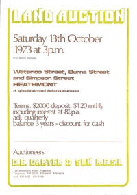 Ringwood and District Historical Society
Document - Folder, Land Auction - Peacock's Estate, Waterloo Street, Heathmont, Victoria - 1973
Photocopy of Certificate of Title and double sided bi-fold leaflet advertising auction of 14 allotments on 13th October 1973 with map of streets, summary of local services and terms of sale. Subdivision includes Waterloo Street, Burns Road (later Dirkala Avenue), and Simpsons Road (later Simpsons Court). Auctioneers - C.E. Carter & Son R.E.S.I. 126 Whitehorse Road, Ringwood, Telephone 870 2519, 870 6830, 870 6024, A.H. 870 0421, 870 3568.Auctioneer's notation of sale prices included on brochure - all sold on day of auction. Vendor Frank Harry Peacock, Tile Burner, named as proprietor of Lot 12 on Plan of Subdivision No. 95654 on Title (Vol 8999 Fol 058). Map shows Dandenong Creek Watercourse as at September, 1971, prior to Dandenong Creek Trail development. -
 Ringwood and District Historical Society
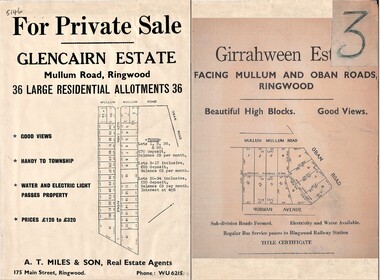
Document - Folder, Land Sale Advertisement, Glencairn Estate and Girrahween Estate, Ringwood - circa 1950s
Single sided advertisement for private sale of residential allotments - undated, circa 1950s.Subdivisions include Mullum Mullum Road,Glen Cairn Avenue (Glencairn), Oban Road, and Norman Avenue (later Hugh Street). Agent - A.T. Miles & Son, 175 Main Street, Ringwood, Phone WU 6215. -
 Ringwood and District Historical Society
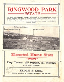
Flyer, Sub-divisional residential land sale advertisement - Ringwood Park Estate, Ringwood, Vic. - circa 1922
Folded double-sided page with black and white photographs of local views with black and red print advertising elevated home sites, including terms of sale, locality map, and description of local facilities and services, with blocks marked as SOLD subsequent to auction sale December 1922. (See Record ID no.5249)Subdivision includes Wonga Road (later Loughnan Road), William Street, Andrew Street, Munro Street and Harrison Street. Estate Agents - Keogh & King, 70 Elizabeth Street, Melbourne, Telephone 6938. -
 Canterbury History Group
Article, Don Gibb, The Elgar's Special Survey
... Land Subdivision...Canterbury McWilliam. Gwen Land Subdivision Port Phillip ...Copy of a talk given by Don Gibb to the Canterbury History Group in June 2015 on the Elgar Survey which will be the basis of the second chapter of his forthcoming book on the social history of Canterbury. Includes maps and a list of the first Boroondara ratepayers.canterbury, mcwilliam. gwen, land subdivision, port phillip district, maps, gibb> don -
 Bacchus Marsh & District Historical Society
Map, Lerderderg Park Lands sale plan. 1911
... Land Subdivision... Land Sales Lerderderg Park Estate Land Subdivision Top: Have ...This plan was for the sale of parcels of land from the Lerderderg Park Estate property in 1911. Advertising for the sale appeared in the Bacchus Marsh Express newspaper through July of 1911. The property was situated only a few kilometers from the township of Bacchus Marsh. The agents for the sale were L. A. Fairbairn & Co.Lerderderg Park Estate was a significant and early colonial property in the Bacchus Marsh area. This plan provides details about the first time the property was subdivided for sale. It is therefore documents an important moment in the history of this property and the broader trend of the subdivision of older and larger properties in the district.A single page paper plan showing allotments of land for sale from the Lerderderg Park property owned by John Wills. The parcels of land for sale are coloured in red.The Lerderderg River and Pyke's Creek Irigation Channel shown on the plan are in blue ink. The rest of the plan is a dark cream or beige colur with the text in black ink. The plan has been extensively annotated with hand-written notes indicating the names of people who purchased the various parcels of lands and the prices paid for those lands. Part of the top of the plan containing some text appears to be missing. The plan is pasted into a bound volume containing 76 maps or plans in total. Top: Have received instructions to Sell, account Mr John Wills, his renowned LERDERDERG PARK LANDS, so well and favourably known throughout the Commonwealth. In areas from 3 acres to 1276 acres. Every lot is either rich lucerne land (or portion now under lucerne) with some higher land adjoining Railway Station, and 2 Milk factories within 2 miles, absolutely the finest land in Victoria. Bottom: THIS IS THE FIRST SUBDIVISIONAL SALE of Rich Flats in Bacchus Marsh since the Pyke's Creek Scheme, and every lot is commanded by it. Only 32 miles from Melbourne.bacchus marsh victoria maps, land sales, lerderderg park estate, land subdivision -
 City of Kingston
Pamphlet - Colour, Arthur Tuckett & Son, Auctioneers and Subdivisional Specialists, Auction of Station Estate, Moorabbin, 1923
... . This land sale pamphlet illustrates the subdivision of land within ...Sales plan for land in the suburb of Moorabbin, bounded by Railway Crescent, South Road, Jasper Road and Pattersons Road.The developing urban area of Moorabbin within the City of Kingston. This land sale pamphlet illustrates the subdivision of land within the municipality and the changing demographic of the district as new houses are constructed.Colour pamphlet advertising an auction of the Station Estate Moorabbin. Incorporates details of the shopping facilities, proximity to the railway line, variety of schools and churches in the area, and a sales plan for home sites and shop fronts. Incorporates a map of the estate bordered by Pattersons Road, Japer Road, South Road and Railway Crescent. Handwritten in grey pencil top right front page: Station Estate / late [indecipherable] Handwritten in red pencil on subdivision map: x [on majority of properties marked on the map] Handwritten in grey pencil on subdivision map: additional subdivisions drawn in and large lines drawn across the mapmoorabbin, land sales, estate -
 Federation University Historical Collection
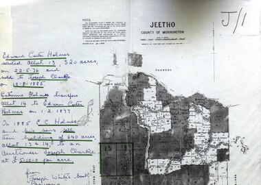
Map - Documents, Documents relating to Land - Selection of Maps of subdivisions; Titles; Cemetery sections
Maps indicate the land owned in various areas of Victoria - Mornington Peninsula, Ascot / Creswick areaLand maps showing block divisions and owners. Edward Carter Holmes J.P. selected land and called it Launchley - later called Wambalano.jeetho, county of mornington, edward carter holmes, joseph clarke, catherine holmes, talbot, william coghill, pre-emptive right, tourello pre-emptive right, glendonald pre-emptive right, clunes, smeaton, ascot, counties of ripon and talbot, certificate of title, ballaarat general cemetery, new cemetery, poowong, helen coghill -
 Bendigo Historical Society Inc.
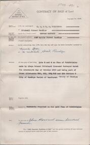
Document - H. A. & S. R. WILKINSON COLLECTION: CONTRACT OF SALE
BHS CollectionContract of sale of land dated 29th November, 1950 between Miss H. Barrass (vendor) and Mrs. M. Speer (purchaser). Property: lots 3 and 4 on plan of subdivision made by Alwyn Ernest Pritchard Licensed Surveyor dated the 19th of October, 1950 and being part of Crown allotment 230, 231, 232, 233 and 125 section H, Parish of Sandhurst City of Bendigo. Price: 3,700 pounds. Attached 8 hand written notes.organization, business, h.a. & s.r wilkinson real estate -
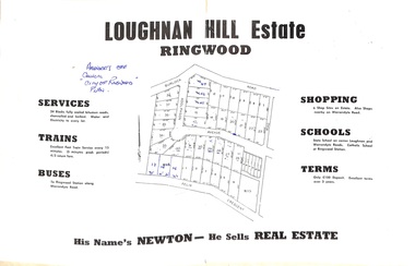 Ringwood and District Historical Society
Document - Folder, Subdivision Map - Loughnan Hill Estate, Ringwood, Victoria - circa 1960
Open centre page of land sale brochure glued to manilla folder. Map of residential and shop sites in Burlock Road (later Burlock Avenue), Adolphson Avenue and Felix Crescent, Ringwood, with summary of estate facilities and local services. Agent - T.G. Newton.(Page glued to manilla folder prevents access to front page for further sale information) -
 Eltham District Historical Society Inc
Photograph - Digital Photograph, Alan King, Pauline Toner Butterfly Reserve, 2008
One of seven sites in Eltham and Greensborough where the butterfly survives. Published: Nillumbik Now and Then / Marguerite Marshall 2008; photographs Alan King with Marguerite Marshall.; p181 The rare Eltham Copper Butterfly, Paralucia pyro-discus, was saved from near extinction by a community campaign in the late 1980s. Thanks to that effort, the butterfly, a form of the Fiery Copper Butterfly, with a wing span of only 2.5cm, can be seen in parts of Eltham and Greensborough from late November to April. As late as 1987 the butterfly was thought to be near extinction. But that year, entomologist, Michael Braby, found several colonies, including two major ones in natural bushland on Diosma Road, Eltham. However these were threatened with destruction, as their habitat was to be destroyed by a development of 71 houses. The colonies were on a 14 hectare subdivision owned by Esanda Finance, an ANZ Bank subsidiary. It would cost around $5 million, to reimburse the bank for the land. The butterfly, which depends on woodland, a stunted form of the Sweet Bursaria bush, and the Notoncus ant, was considered too fragile to relocate. Braby’s discovery led to a sometimes fiery two-year campaign, which even became an election issue. It involved the local community, local and state governments and the developer, before a compromise was reached. The larvae have an intricate relationship with the small black ant, Notoncus. During the day, the larvae shelter in nests made by the ants around the base of the trunk and roots of the Sweet Bursaria (Bursaria spinosa). The ants are thought to protect the larvae from predators and parasites, as they attend them from the nests to feed on the Bursaria leaves at night. In return, the larvae excrete a sugar solution, which the ants love to eat. The butterfly was first recorded in Victoria in 1893, and first collected scientifically from Eltham in 1931. But it was only officially named in 1951, by Victoria’s then top butterfly expert, David Crosby.2 However, from 1970, rapid housing development in Eltham destroyed much of the butterfly’s habitat. The discovery of several major colonies in 1987 met with great excitement, and 250 people attended the first local public meeting. The State Government commissioned Crosby to investigate how to protect the butterfly, and the council froze development for three weeks. Then Esanda agreed to suspend development for several months, until a compromise was reached. Crosby recommended that 62 of the 71 lots be kept to ensure the butterflys’ survival. However this would cost $1 million to $1.5million in compensation to Esanda. Greensborough MP Pauline Toner, launched a $1million fundraising campaign and many artists donated their works to the appeal. Toner offered Clifton Pugh’s painting Eltham Copper Country to millionaire Alan Bond for $1 million, after having heard that he had offered $6 million for the Van Gough painting Sunflowers. However Bond did not accept. The butterfly was considered a ‘hot’ election issue during the by-election, following Pauline Toner’s resignation. Liberal party candidate, Margaret Brown, was accused of falsely saying she had been involved in the butterfly campaign so as to win votes. Sadly, the $1million appeal fell short at $426,000, so a compromise was reached. The State Government donated the Education Department site on Eucalyptus Road, but only nine lots of the Diosma site were bought, and the rest of the development went ahead. On March 3, 1989, Ms Toner died. Thee Eucalyptus Road site was named in her honour. Around 2000 the butterfly was further threatened by proposed developments on Pitt Street, facing the Pauline Toner Reserve and between Diosma and Nyora Roads. Fortunately the Friends of the ECB, with the Shire of Nillumbik, ensured that more habitat was made available. The butterfly now survives in seven sites in Eltham and Greensborough, including the main sites at the Pauline Toner Reserve on Eucalyptus Road, the Western and Eastern colonies on Diosma Road, and the Yandell Reserve in Greensborough.5 The butterfly survives also in Castlemaine and in the Kiata and Salisbury areas. However, it remains endangered.This collection of almost 130 photos about places and people within the Shire of Nillumbik, an urban and rural municipality in Melbourne's north, contributes to an understanding of the history of the Shire. Published in 2008 immediately prior to the Black Saturday bushfires of February 7, 2009, it documents sites that were impacted, and in some cases destroyed by the fires. It includes photographs taken especially for the publication, creating a unique time capsule representing the Shire in the early 21st century. It remains the most recent comprehenesive publication devoted to the Shire's history connecting local residents to the past. nillumbik now and then (marshall-king) collection, eltham copper butterfly, pauline toner butterfly reserve -
 Eltham District Historical Society Inc
Photograph - Digital Photograph, Alan King, Sweet Bursaria, 2008
Published: Nillumbik Now and Then / Marguerite Marshall 2008; photographs Alan King with Marguerite Marshall.; p181 The rare Eltham Copper Butterfly, Paralucia pyro-discus, was saved from near extinction by a community campaign in the late 1980s. Thanks to that effort, the butterfly, a form of the Fiery Copper Butterfly, with a wing span of only 2.5cm, can be seen in parts of Eltham and Greensborough from late November to April. As late as 1987 the butterfly was thought to be near extinction. But that year, entomologist, Michael Braby, found several colonies, including two major ones in natural bushland on Diosma Road, Eltham. However these were threatened with destruction, as their habitat was to be destroyed by a development of 71 houses. The colonies were on a 14 hectare subdivision owned by Esanda Finance, an ANZ Bank subsidiary. It would cost around $5 million, to reimburse the bank for the land. The butterfly, which depends on woodland, a stunted form of the Sweet Bursaria bush, and the Notoncus ant, was considered too fragile to relocate. Braby’s discovery led to a sometimes fiery two-year campaign, which even became an election issue. It involved the local community, local and state governments and the developer, before a compromise was reached. The larvae have an intricate relationship with the small black ant, Notoncus. During the day, the larvae shelter in nests made by the ants around the base of the trunk and roots of the Sweet Bursaria (Bursaria spinosa). The ants are thought to protect the larvae from predators and parasites, as they attend them from the nests to feed on the Bursaria leaves at night. In return, the larvae excrete a sugar solution, which the ants love to eat. The butterfly was first recorded in Victoria in 1893, and first collected scientifically from Eltham in 1931. But it was only officially named in 1951, by Victoria’s then top butterfly expert, David Crosby.2 However, from 1970, rapid housing development in Eltham destroyed much of the butterfly’s habitat. The discovery of several major colonies in 1987 met with great excitement, and 250 people attended the first local public meeting. The State Government commissioned Crosby to investigate how to protect the butterfly, and the council froze development for three weeks. Then Esanda agreed to suspend development for several months, until a compromise was reached. Crosby recommended that 62 of the 71 lots be kept to ensure the butterflys’ survival. However this would cost $1 million to $1.5million in compensation to Esanda. Greensborough MP Pauline Toner, launched a $1million fundraising campaign and many artists donated their works to the appeal. Toner offered Clifton Pugh’s painting Eltham Copper Country to millionaire Alan Bond for $1 million, after having heard that he had offered $6 million for the Van Gough painting Sunflowers. However Bond did not accept. The butterfly was considered a ‘hot’ election issue during the by-election, following Pauline Toner’s resignation. Liberal party candidate, Margaret Brown, was accused of falsely saying she had been involved in the butterfly campaign so as to win votes. Sadly, the $1million appeal fell short at $426,000, so a compromise was reached. The State Government donated the Education Department site on Eucalyptus Road, but only nine lots of the Diosma site were bought, and the rest of the development went ahead. On March 3, 1989, Ms Toner died, and the Eucalyptus Road site was named in her honour. Around 2000 the butterfly was further threatened by proposed developments on Pitt Street, facing the Pauline Toner Reserve and between Diosma and Nyora Roads. Fortunately the Friends of the ECB, with the Shire of Nillumbik, ensured that more habitat was made available. The butterfly now survives in seven sites in Eltham and Greensborough, including the main sites at the Pauline Toner Reserve on Eucalyptus Road, the Western and Eastern colonies on Diosma Road, and the Yandell Reserve in Greensborough.The butterfly survives also in Castlemaine and in the Kiata and Salisbury areas. However, it remains endangered.This collection of almost 130 photos about places and people within the Shire of Nillumbik, an urban and rural municipality in Melbourne's north, contributes to an understanding of the history of the Shire. Published in 2008 immediately prior to the Black Saturday bushfires of February 7, 2009, it documents sites that were impacted, and in some cases destroyed by the fires. It includes photographs taken especially for the publication, creating a unique time capsule representing the Shire in the early 21st century. It remains the most recent comprehenesive publication devoted to the Shire's history connecting local residents to the past. nillumbik now and then (marshall-king) collection, eltham copper butterfly, sweet bursaria -
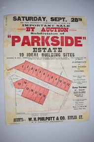 Warrnambool and District Historical Society Inc.
Work on paper - Original Document, H J Paynter, Advertisement "Parkside"Estate subdivision, Circa 1935
This sheet denotes an auction of land which is situated close to Albert Park on the northern part of Warrnambool. The area is complete now with homes which are a mixture of brick and concrete faced houses. The agent W H Philpott was operating in Warrnambool from the 1930's though to 1950'sThis item has local interest and significance as it records the sale of Warrnambool land.Large white paper sheet with black and red text. The auction details are at the top and down the righthand side with a map of the available blocks are coloured red and outlined in black.Parkside estate, W H Philpott & Co Kepler St , R V Philpott auctioneer,Solicitors J S Tait & son. Cramer Street, Nelson Street McConnell Street.warrnambool, mcconnell street warrnambool -
 Ringwood and District Historical Society
Document - Biography - Family Tree Extract, Alexander William Brown (1885-1957) - Nurseryman, Grandview Grove Ringwood (Warranwood) Vic
A4 folder containing genealogical information, copy of will and copy of probate administration record including real estate assets for A.W. Brown, Grandview Grove Ringwood (Warranwood) Vic.EXTRACT: Inventory of Real Estate Assets (for Probate purposes) 1. Grandview Grove, Ringwood Land containing 10 acres or thereabouts situate in Grandview Grove Ringwood being part of Crown Section 20 Parish of Warrandyte County of Evelyn and being the land described in Certificate of Title Volume 5781 Folio 174 on which is erected a 7 room house, a bungalow, shed and 2 glass houses valued by E. Miles, Ringwood - £5077-0-0 2. Kardinia Crescent, Ringwood Land containing 2 acres 3 roods 24-1/2 perches situate in Kardinia Crescent Ringwood being Lots 33 and 34 on Plan of Subdivision Number 12040 and being part of Crown Section 20 Parish of Warrandyte County of Evelyn and being the land described in Certificate of Title Volume 7141 Folio 080 valued by E. Miles at £350-0-0 -
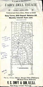 Ringwood and District Historical Society
Flyer, Residential Land Sale Sub-division - Fairy Dell Estate, Warranwood, Vic. - circa 1950s
Land sale advertisement for 50 home sites with map of Sub-division showing layout of streets and allotments, summary of local features and services and terms of sale, and copy of sectional map of Crown Allotments 20 & 21B Parish of Warrandyte also showing layout of Sub-division.Subdivision includes Grandview Grove (later Bemboka Road), Merrill Crescent and Kerry Road, Warranwood. Estate Agents - V.C. Swift & Son R.E.S.I., Main Street, Croydon, Phone 20. Solicitors - Morgan, Fyffe & Mulkearns, 108 Queen Street, Melbourne. Handwritten 1970s real estate price notations for some blocks. -
Glen Eira Historical Society
Document - Christian Family
... Land Subdivision... Slate Tiles Roofs Chimneys Fireplaces Land Subdivision Coach ...Six documents on the Christian Family. Nine typed pages by Robert Trumble dated 08/02/1974. Extracts taken from two books written by him about the Christian family in Australia. Three pages about Thomas Christian and Myoora from Caulfield Historical Society Newsletter April/June 1974. Handwritten notes on Thomas and Violet Christian from 1886-1891, possibly taken from Rate Books, unsigned and undated. Handwritten information from the Public Record Office Victoria giving extract of register of Wills, Vol.W1, page 39 Christian, Thomas. Unsigned and undated. Photocopied UK incoming passenger list dated 28/04/1899 showing Mrs. Christian, eight children and maid on the ship Wakool, from Ancestry.com.au Newspaper item dated 26/01/2013 from the Saturday Age mentioning Coolart Homestead, late Victorian mansion, owned at one stage by Tom Luxton who was married to Gertrude Christian.christian thomas, christian violet mary, christian dorothy, christian emily, barclay frank, baker blanch miss, christian florence, trumble hugh, christian arthur james, christian may, player charles dr., llaneast, house names, player janet, player alison, player dorothy, myoora, christian gertrude, christian grace, richards henry caselli, richards harry, trumble robert, trumble kathleen, christian dorothy, dandenong road, caulfield, luxton thomas j., trumble ken, christian edgar john, emery irene, the golden age of cricket, the trumble family in australia, dunstan john r., o’donnell j., caulfield historical society, alma road, hawthorn road, dandenong road, craigellachie, orrong road, p.c. day dawn, p.c. gold mining company ltd., charters towers, mines and mining, gold mining, balconies, verandahs, cast iron work, towers, stained glass, mansions, ievers william, pfeiffer frederick, newmann violet mary, lloyd john charles, architects, brooke family, servants, stairs, teacher work, cellars, flats, slate tiles, roofs, chimneys, fireplaces, land subdivision, coach houses, reed henderson and smart (architects), wills, ships, wakool, henderson anketell -
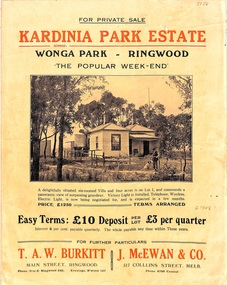 Ringwood and District Historical Society
Flyer, Land Sale Brochure, Kardinia Park Estate, North Ringwood, Vic. - circa 1948
Folded buff-coloured land sale advertisement for Kardinia Park Estate in Warranwood area of North Ringwood, including terms of sale, area map, layout plan of the estate, and summary of local facilities and services. Front page features photograph of a man and dog in front of a house captioned as Lot 1 on four acres shown on the estate layout as cnr of Brysons Road and Range View Parade (later Omeo Parade). Second page includes bushland swimming pool photograph and promotional information for prospective buyers.Subdivision includes Kardinia Crescent, Wonga Road, Brysons Road, Range View Parade (later Omeo Parade), Motor Coach Road (later Wonga Park Road, then Warranwood Road). (Agent/s) T.A.W. Burkitt, Main Street, Ringwood, Phone (9 to 6) Ringwood 242, Evenings, Ringwood 157, and J. McEwan & Co, 317 Collins Street, Melbourne, Phone 6750 Central.