Showing 1592 items
matching looking south
-
 Federation University Historical Collection
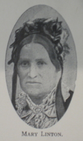
Booklet, H.P. Benett, Looking back over 100 Years. 1839-1939: A Brief Historical Review on the Settlement and Development of Linton and District, 1939
... Linton looking South; Albert Kennedy; N. Wishart... north; Sussex Street Linton looking South; Albert Kennedy; N ...This book was published for the centenary of white settlement at Linton. Wardy Yallock is the Aboriginal name for the district now know as Linton.Soft cream covered booklet of 42 pages. Topics include pioneers; gold; mining; civic development; municipal history, education, churches, racing, athletics, football, rifle shooting;tennis, golf;fire brigade, band, horticultural society, Linton Free Library; friendly ; societies; post office; railway; police; war; old Lintonians' Association. Images include: Ewen Rankin; Robert Rankin; John Linton; R. Ching; Mary Linton; James Nicol; J.H. Roberts; W.G. Bennett; Robert Linton; Digory Roberts; W. Campbell; W. Todd; B. Oulten; W. White; Rev. Campbell; J. Wearne; J.G.Allan; R.S. Nelson; Victory Mine; South Victoria Mine; Samuel Lewers; M.H. Baird; Thomas Younghusband; Joseph Shepherd; Thomas Kennedy; John Clarke; James Dodds; G.H. Smith; Linton State School; Sussex Street Linton Looking north; Sussex Street Linton looking South; Albert Kennedy; N. Wishartlinton, lintons diggings, wardy yallock, george sandow, mt bute station, emu hill, matthew hamilton, samuel lewers, john clarke, joseph shepherd, edward morey, james nicol, wg bennett, edwin ball, thomas bryant, william white, ewen cameron, john cameron, bryson campbell, james woodrow -
 Glenelg Shire Council Cultural Collection
Print - Contact Print - Pastoral Scene, 1960-1979
... right: Dutton Way beach, looking towards south. Bottom left... bushland and beneath bridge. Top right: Dutton Way beach, looking ...Sheet of 4 contact prints from glass plate negatives. Top left: Stream running through bushland and beneath bridge. Top right: Dutton Way beach, looking towards south. Bottom left: Whalers Bluff with lighthouse from Dutton Way. Bottom right: 3 women sitting at small table, taking tea. Outdoor scene, ivy-clad wall behind them. They are dressed in late 19th, early 20th century fashion. -
 Whitehorse Historical Society Inc.
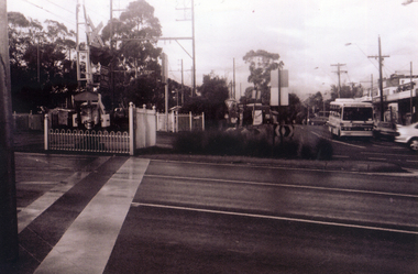
Photograph, Pedestrian Crossing & Nunawading Railway Station, 1/06/2009
... . This photograph is looking over the south side of the intersection... Railway crossing. This photograph is looking over the south side ...One of a collection of photographs taken of the Nunawading Railway Station prior to the lowering of the railway line and building of the new railway station on the western side of Springvale Road so that the Springvale Road Rail Crossing can be eliminated.Black & white photograph of the precinct surrounding the Nunawading Station and the Springvale Road Railway crossing. This photograph is looking over the south side of the intersection in Springvale, to the pedestrian crossing and the Railway Station. The shopping centre is on the right hand side. See NP 3545 to NP3567 for the complete set of photographsnunawading railway station, springvale road nunawading, redevelopment of railway line/springvale road. -
 Ballarat Tramway Museum
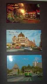
Album - Photo Album, Newstar, 1960s to 1970's
... 42, early 1960's. Page 7 - Swanston St looking south... - Swanston St looking south at Little Bourke, W2's 373 route 67 ...Photographic album containing 39 Colour postcards of Melbourne trams. The album consists of 30 leaves of dark grey heavy paper with three creases on left hand side of sheet, bound into a heavy bluey grey folder, embossed in gold 'Scrap Book" and bound with bluey grey string with two holes. The cover has been embossed with a the blue grey in swirls. Inside of back cover is a white label, "A New Star Product", with a please ask for No. with "425" stamped on. Postcards have been glued into the album. Entries have been kept to a single line - cards are able to be dated from buildings, whether the trams have marker lights, types of motor cars and general Melbourne history. Image files in page number order. Image 15 is of book. All taken with a electronic camera. Page 1 - Night photo - Flinders and Swanston St. - with "Greetings from Huntingdale" embossed in gold. Flinders St. station, with "Greetings from Huntingdale" embossed in gold. (post 1972 ) St. Kilda road with the Shrine of Remembrance in the background and W2 453 inbound on route 6. (post 1974) Page 2 - Bourke St, looking from Parliament House westwards, with Z8 inbound - after 13/8/1975 on route 89. Bourke St, looking east from Queen St., night photo, early 1970's. Princes Bridge looking towards Flinders St. Station Page 3 - Flinders St. Station, from Princes Gate buildings, - Photo E. Ludwig, John Hinde Studios. Bourke St. from Queen St, looking east, late 1960's - all W's. - W7 1026 east bound on route 88. Flinders St and Swanston St. corner, from Princes Bridge - night photo - W5 756 northbound route 15. Page 4 - W2 584 inbound route 64, St. Kilda Road and Nolan St., late 1960s - photograph. Princes Bridge, looking over Yarra River to the east. (pre Concert Hall) St. Kilda Road, with Shine of Remembrance in background, W2 303 inbound route 4D, mid 1960's. Page 5 - Flinders and Swanston St, W2 530 outbound route 8, early 1970's. Swanston and Collins St., W2 596 westbound in Collins St. City Square built - 1st version. (post 1972) St Kilda Road, with Shine in background, W2 298 and others, route 8 and 72. (post 1972) Page 6 - Flinders and Swanston St., W2, inbound route 5 on a wet evening. (mid 1970's) W2 515 outbound, Collins St., late 1960's, with Town Hall in background. (early 1970's, prior to lights) Collins St. looking west at Russell St with W2 637outbound route 42, early 1960's. Page 7 - Swanston St looking south at Little Bourke, W2's 373 route 67 and 374?(route 5), southbound, early 1970's Flinders St. Station, looking west in Flinders St., early 1970's, at dusk. Melbourne Town Hall with City Square from the North West (early 1970's) Page 8 - Bourke St looking east from Queen St. with W7 1005 inbound on route 96 - early 1970's. Bourke St. looking west from Exhibition St. with W6 976 outbound on route 95 - early 1970's. Swanston St. looking south from Lonsdale, with W2 484 on route 64, W2 228 and W2 364 in photo - early 1970's. Page 9 - Swanston looking south from north of Lonsdale St with many tramcars in photo - mid 1970's. St Kilda Road, with Shrine in background, W2 345 outbound route 4, SW6 913 inbound route 4 - prior to 1970. St Kilda Road, with Shrine in background, with trams in photo - early 1970's. (Photo loose in album - National View postcard by Murfett Ltd. Aust.) Page 10 - Postcard - TMSV? of 1041 and cable car set at Preston Workshops. 1041 in Bourke St., looking east from Queen St. - early 1970's - 1974? Collins St. looking east from Elizabeth St. with W2 253 inbound route 11, and W2 224 outbound - rout 47, early 1970's Page 11 - TMSV Postcard, X217 in Dandenong Road with L class in background. Shrine of Remberance from BP building, looking towards the city with St. Kilda Road on the left. Princes Gate and Flinders St. from the SEC buildings in Flinders St. looking south east - mid 1960's. Page 12 - Swanston St. at Flinders St. looking north at dusk. Flinders St. station at Swanston St with trams crossing at intersection - late 1960's Flinders St. station with W2 327 outbound. Page 13 - Temporary City Square at Collins and Swanston St. with tramcars at intersection. Wellington Parade (Mugs Alley), looking towards the City, with W2 546 inbound on route 38 - mid to late 1960's. Page 14 - Swanston St. looking south, at Lonsdale St, W2 432 inbound route 7 - late 1960's or early 1970's. Partly loose in album - National View postcard by Murfett Ltd. Aust. trams, tramways, photo album, melbourne, postcards -
 Glen Eira Historical Society
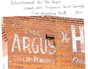
Photograph - CARNEGIE
... Koornang Road. 6/Slide showing Koornang Road, Carnegie looking..., Carnegie looking South. 7/6 photocopied postcards from Valentines ...24 photographs relating to Carnegie plus 1 slide: 1/Two photographs, one of Koornang Road c.1920’s and one of flower shop rear of library, date unknown. 2/One photograph of Carnegie Post Office c. undated. 3/Two photographs Koornang Road, Carnegie and phone boxes, Carnegie, dated 1914. 4/Two photographs (the same) of an RSL Ball dated 15/08/1937. 5/17 black and white negative photos – reprinted, date unknown, of Carnegie Library, shop front opening Koornang Road. 6/Slide showing Koornang Road, Carnegie looking South. 7/6 photocopied postcards from Valentines Real Photo Series, in album owned by Mrs. Zoe Mason, collected and returned to Pam Speedy (daughter) 12 Wattle Grove, East Malvern, 15/03/1999. Photocopied pages from 1923 Sands and McDougalls included with some prints to give an idea of architecture and other retail trade. 8/Two photocopied prints of Carnegie Flood. 1946 – Koornang Road, shows shopkeepers in street at that time. 9/Two photographs of brick wall advertising the "Argus" newpaper, which closed in 1957. Photos taken in 2011 when building was exposed prior to rebuilding on site.koornang road, rosstown road, carnegie, shepparson street, carnegie library, carnegie post office, mcallister b., glen huntly, glenhuntly, phone boxes, memorial hall, bamfield m., tranmere avenue, carnegie railway station, stations, libraries, post offices, memorial hall carnegie, progress hall, carnegie community singing, social clubs, chadstone progress, newspapers, temminghoff robert, carnegie chamber of commerce, caulfield city council, rob’s chocolate box, rosstown, ross william murray, rosstown railway, elsternwick, oakleigh, city of caulfield, glen huntly road, glenhuntly road, grange road, carnegie primary school, primary schools, murrumbeena, neerim road, dandenong road, koornang park, lord reserve, rosanna street reserve, packer oval reserve, caulfield swim centre, holywood grove, mile end road, mcpherson avenue, munster avenue, rosstown hotel, leila road, methodist church, toolambool street, carnegie theatre, carnegie estate agency – sims and broadbent, woorayl street, estate agents, cowie j. mrs., confectioner, woodhouse e., stationer, mckay jno. a., mckay jonathon, small goods, perry w. b., chemists, kinsman e. h., newsagents, jones a. w., mckee wm., furniture stores, neil geo. m., grocer, truganini road, brick -
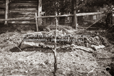 Eltham District Historical Society Inc
Photograph, Charles Withers (aka Bill) and his friend Mervyn Britain (left) in their trench at Southernwood, Eltham, 1916
... family home, Southernwood, Eltham. The view is possibly looking... family home, Southernwood, Eltham. The view is possibly looking ...Charles Withers (aka Bill) with his good friend from school, Mervyn Britain with mock trenches and rifles at the Withers family home, Southernwood, Eltham. The view is possibly looking to the south and Southernwood family home [Charles son, John Withers explained that his father and friend liked to play war games.]Many items in this collection have suffered from significant water damage and black mouldjohn withers collection, eltham, 1916, bill, mervyn, southernwood, trenches, scan - 620 format 6x9 negative, charles meynell pitt withers, mervyn britain -
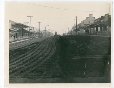 Orbost & District Historical Society
Photograph - black and white photograph, Nicholson Street 1984 works
... the south and looking northwards. Nicholson Street is the main... from the south and looking northwards. Nicholson Street ...This is a photograph of Nicholson Street, Orbost taken from the south and looking northwards. Nicholson Street is the main commercial street of Orbost and this photo is of a re-shaping of the street done in c. 1984 by Orbost Shire Council. Shows evidence of the maintenance works done to refurbish the main street of Orbost A B/W photograph H-20cm W-25.4cm of a street with buildings on both sides of the street. A piece of earth-moving machinery is working in the background on the street. nicholson street, orbost -
 Whitehorse Historical Society Inc.
Photograph, View from Mitcham Pedestrian Bridge, 1/07/2000 12:00:00 AM
... , looking towards Mitcham right (south) side. Cars parked front... pedestrian overpass on Whitehorse Road, looking towards Mitcham right ...Coloured view from pedestrian overpass on Whitehorse Road, looking towards Mitcham right (south) side. Cars parked front into gutter in mid ground are parked in front of St Johns Catholic Church.mitcham, whitehorse road -
 Federation University Historical Collection
Booklet, Back to Bacchus Marsh, 1930, 1930
... * Aerial View of Bacchus Marsh Township looking south * Bacchus... looking south * Bacchus Marsh Agricultural Society & Pastoral ...The 1930 Back to Bacchus Marsh celebrations were held on 23 to 28 October 1930. The committee were Cr L.M. Gugdale (president), A.W. Bond (General secretary), W. Grant Morton, J.G. Wells, Dr E. McDonald, Charles Dickie, G.H. Anderson, F.M. Crisp, W.R. Vigor. Bacchus Marsh State School No. 28 was established in 1851 as a National School in a rented building on the right-hand side of Bacchus Marsh-Melbourne Road, just beyond Woolpack Inn. Several willow trees mark the site. H.G. Ball was the first Head Teacher of the school, and the enrolmen towas 34. In 1854 Governor Charles Hotham visited the school. In 1855 two new schools, East and West, were recommended. School No. 28 closed in 1862 and the sitre was sold. The present school site was purchased in 1865 for 67 pounds. The cost of the building was 782 pounds. (Visions and Realisations, Vol 3., 1973) A clock purchased by public subscription was placed in the front of the building to the memory of scholars who served during World War One. (Back to Bacchus Marsh, 1930)Brown covered book of 44 pages. Contents include Bacchus Marsh and its soldiers, Red Cross, Lerderderg Gorge, Werribee Gorge, Lerderderg Park, Coimadai, Darely Firebrick Co., Myrniong, Underbank, Balliang, Rowsley, Parwan, schoosl, churches, Shire Council, Federal Milk Pty Ltd, Bacchus Marsh Milk, Old Maddingley Bridge Images include: * Bacchus Marsh looking east, 1930 * Bacchus Marsh Looking West, 1872 * Bacchus Marsh Looking West, 1930 * Aerial View of Bacchus Marsh Township looking east * Aerial View of Bacchus Marsh Township looking south * Bacchus Marsh Agricultural Society & Pastoral Society, 1893 (named), * Original Bacchus Marsh State School No 28 * Holy Trinity Bacchus Marsh * Bacchus Marsh Baptist Church * St Bernard's Catholic Church * Bacchus Marsh Methodist Church * St Andrew's Presbyterian Church Bacchus Marsh * View of Maddingley Park, showing Original Courthouse, 1890 * Werribee Gorge * Underbank Stud Farm * Ballarat State School Number 28. Signed 'C. Hodgson'bacchus marsh, maddingley, maddingley park, underbank, lerderderg park, coimadai, darely firebrick co., myrniong, balliang, rowsley, parwan, schoosl, churches, shire council, federal milk pty ltd, bacchus marsh milk, old maddingley bridge, police, police paddock, maddingley gates, crisp, mccormack, cain, harkness, howe, bence, mcdonald, mcfarlane, cosgrave, flagg, burnip, scott, lodge, cameron, vallance, bacchus marsh state school, bacchus marsh state school no 28., geology, r.w. thompson, lederderg gorge, weribee gorge, comadai, darley firebrick company -
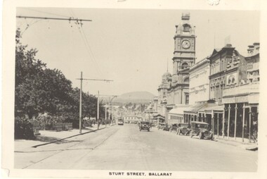
 Ballarat Tramway Museum
Slide - 27 mm sq slide/s - set of 3, Lilian Butler, Sturt St and Ripon Sts, 1971
... Britton 26/9/2016 - by e-mail) 3 - looking west - South side...Ballarat Tramway Museum South Gardens Reserve Wendouree ...Yields information about Ripon St, Talbot St.Set of 3 Hanimex slides - what cardboard mounts: 1 - View Point line junction at Ripon St, looking north west with short tram stop pole and Ampol service station sign on the right. 2 - Water column North West corner of Sturt Street and Talbot Street (opposite the Fire Station). Column long gone. (Advised by Neville Britton 26/9/2016 - by e-mail) 3 - looking west - South side of Sturt St. Photo from the collection of Lilian Butlerballarat, tramways, trams, sturt st, view point, ripon st, tram stops -
 Ballarat Tramway Museum
Slide - 27 mm sq slide/s - set of 9, Lilian Butler, View Point line:, 1971
... and Sturt St, looking south with the Western Hotel in the view... and Sturt St, looking south with the Western Hotel in the view ...Yields information about the View Point line.Set of 8 Hanimex colour slides, white cardboard mount and one AGFA blue and white plastic mount slide of the View Point line: .1 - Point where the View Point line crossed from Ripon St to Wendouree Parade at Webster St. .2 - Trackwork arrangement at the intersection of Ripon St and Sturt St - shows blue stone paving around the tracks. .3 - Ballarat A Power Station - Wendouree Parade and Ripon St .4 - View Point track looking North near the boat sheds. .5 - View Point looking north to the Lake View Hotel, shows part of the View Point loop which has been removed. .6 - Trackwork arrangement at the intersection of Ripon and Sturt St, looking south with the Western Hotel in the view. Shows the shelter at the left hand side. .7 - View of the View Point Loop, with a warning on coming trams sign and the Hotel in the far distance. .8 - View of the curves at Mair and Ripon St. .9 - Looking north from the View Point terminus along Wendouree Parade. Photo from the collection of Lilian Butler. ballarat, tramways, trams, wendouree parade, ripon st, view point, ballarat a power station, sturt st, shelters, signs, mair st -
 Orbost & District Historical Society... the south and looking northwards. This is the main street in Orbost... the south and looking northwards. This is the main street in Orbost ...This photo is of Nicholson Street, Orbost, taken from the south and looking northwards. This is the main street in Orbost, with most of the businesses, banks etc. in this street. In 1984, Orbost Shire Council proceeded to do a refurbishing of the main street and this photo is likely from that time. This photo shows one of the steps in the progression of Orbost. B/W photograph of a street with buildings on rt. and left and a grader or earth moving equipment working in the background on the street. This photo is H-200mm W-254mm.orbost - nicholson street - streetscaping
 -
 Ballarat Tramway Museum
Photograph - Digital image Set of 28, Mal Rowe, 21/09/2019 12:00:00 AM
... by Mal Rowe on 21/9/2019. .1 - View looking south from depot.../2019. .1 - View looking south from depot junction showing ...Set of 28 digital images of the 2019 Tramcar Showcase by Mal Rowe on 21/9/2019. .1 - View looking south from depot junction showing the track replacement pending the final asphalt layer. .2 - looking north towards depot junction .3 - 27 crossing Wendouree Parade .4 - 14 crossing with John Phillips ex MMTB Mk III Bus in the background. .5 - 13on the access track. .6 - 8 on the depot fan .7 - Cavalcade line up lead by 26 .8 - ditto .9 - group photo being arranged .10 - Cavalcade line up lead by 26 .11 - ditto .12 - 28 returning to the depot. .13 - ditto .14 - 27 returning to the depot on the access track. .15 - 18 ditto .16 - 18 ditto .17 - 13 ditto .18 - 13 ditto .19 - 18 ditto .20 - 40 running in with Mk III bus in the background .21 - 40 on the access track .22 - ditto .23 - 38 on the access track .24 - close up of the 22E truck .25 - depot fan in general. .26 - 14 on the access track .27 - 38 on the access track .28 - 38 dittotrams, tramways, btm, tramcar showcase, events, cavalcade, wendouree parade, trackwork, buses, 22e trucks, depot, tram 13, tram 38, tram 26, tram 14, tram 8, tram 27, tram 14, tram 28, tram 18, tram 27, tram 38, tram 40, tram 671 -
 Rutherglen Historical Society
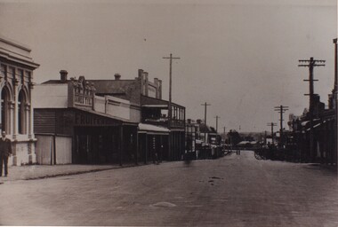
Image, 18/05/1892
... Street looking West. on the south side of the street can be seen... of Rutherglen Main Street looking West. on the south side of the street ...Identity of 'Jack' and 'Judy' unknown.Black and white postcard photograph of Rutherglen Main Street looking West. on the south side of the street can be seen the bank at the corner of Main and High Streets, James Tye's fruit and vegetable shop, the Rutherglen Hotel, and the Cumberland Hotel further down the street.Message written on back: "Rutherglen 18/5/92 / Dear Jack, As you can see by the front of this card - Things have been pretty quiet since you have been away! I know that you are on the improve now - and have been walking - so that is great news. Keep up the good work. Haven't sold a bird - yet - have sold a tea towel though. All are missing you at the 'Paris End' of Main Street - so home soon I hope. / Best wishes. Judy."main street, rutherglen hotel, james tye fruiterer -
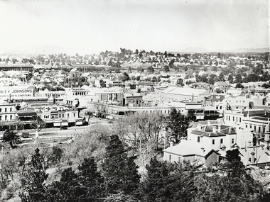 Bendigo Historical Society Inc.
Photograph - BENDIGO LANDSCAPE 1937, 1937
... tower looking east of south towards Railway Station, shows... of Bendigo CBD from lookout tower looking east of south towards ...black and white photo: view of Bendigo CBD from lookout tower looking east of south towards Railway Station, shows Sandhurst Club at bottom right corner, Queen Victoria statue in gardens, intersection of Pall Mall, Mitchell and View Strets. In image ' ...rley Johnsons ' Mathews Bros' ' Plume' ' Plaza' ' A.E. Sayer' On back ' Bendigo, Victoria, 1937, Ellison Coll'place, landscape view, bendigo -
 Ballarat Tramway Museum
Photograph - Digital image Set of 10, Tony Smith, 5/09/1971 12:00:00 AM
... truckers at the Mt Pleasant terminus. .7 - View looking south... Pleasant terminus. .7 - View looking south along Ripon St from ...Yields information about Ballarat Tramways and trams prior to the closure of the tramway system.Set of 10 digital images of Ballarat trams prior to closure, scanned from original slides by Tony Smith, 1971 prior to closure of the system. This set of slides, possibly on the last weekend of Mt Pleasant services - closure took place on 5/9/1971. .1 - 13 outbound in Barkly St, Mt Pleasant - with another single trucker and the Ballarat Fire Station in the background. .2 - Bogie tram and single trucker at Grant St Loop. Has the Mobile service station on the right hand side. Note the family sitting on the steps of a house on the left side watching proceedings. .3 - 14 (Mt Pleasant) and 39 ditto. .4 - 27? and 39 crossing at the Morrison St loop. .5 - 14 and another single trucker at Mt Pleasant terminus. Has the corner store in the background with adverts for Robur Tea, Womens Weekly and Coca Cola. .6 - 39 and two single truckers at the Mt Pleasant terminus. .7 - View looking south along Ripon St from Mair St, with power station buildings on the right hand side. Shows the power distribution poles on the street. .8 - Scrubber tram on 0 road with tennis court alongside. .9 - 40 running special in Wendouree Parade, near the Haddon St intersection. .10 - 40 turning from Macarthur St into Drummond St Nth.trams, tramways, mt pleasant, barkly st, grant st, victoria park, sturt st west, ripon st, view st, depot, wendouree parade, drummond st nth, macarthur st, closure, tram 14, tram 39, tram 13, tram 26, tram scrubber, 40 -
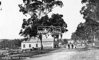
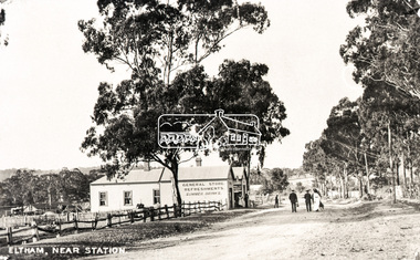
 Eltham District Historical Society Inc
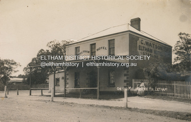
Photograph, Watson's Eltham Hotel on the Melbourne Road, Eltham, 1908
... - The Watsons married in 1907 View looking south on Main Road towards... - The Watsons married in 1907 View looking south on Main Road towards ...The Eltham Hotel was opened in 1854 situated on the south east corner of Main Road (Maria Street) and Pitt Street. Post card dated Eltham 2.1.1908 sent to Mr C. Watson "Malvale" Mardan Inscribed "Wishing you a Brigt and Happy New Year from Florrie" Most likley sent by Florence May Shillinglaw to sister Carrie Watson and new brother-in-law Christopher Watson - The Watsons married in 1907 View looking south on Main Road towards Pitt Street and Watson's Eltham Hotel on left. At this time, the hotel was run by Christopher Watson Jnr. Carrie Shillinglaw had recently married his son, Christopher. Ultimately the hotel would pass to his youngest son, Herbert James (Jim) Watson who demolished the original building in 1925 and erected a new modern building on the same site that remains in present time though modified several times over the years. See also EDHS_00133 POSTCARD 1905-1940s Like the carte-de-visite, postcards enjoyed a collecting craze by large numbers of people, and were often kept in albums through which the interested visitor could browse. Postcards were posted or exchanged in huge numbers. Postal authorities in Australia only allowed the private printing of postcards from 1898. At this time the back of the card was reserved for the address and postage stamp, and the front was used for the message and a picture. In 1902 British authorities allowed a "divided back", so that the left side could be used for the message, the right side for the address and stamp, and the whole of the front was devoted to the picture. France followed suit in 1904, Germany and Australia in 1905, and the United States in 1907. - Frost, Lenore; Dating Family Photos 1850-1920; Valiant Press Pty. Ltd., Berwick, Victoria 1991marg ball collection, postcard, eltham hotel, florence may bunker (nee shillinglaw) (1886-1969), main road, pitt street, caroline (carrie) watson (nee shillinglaw 1876-1956), christopher watson, 1908 -
 Eltham District Historical Society Inc
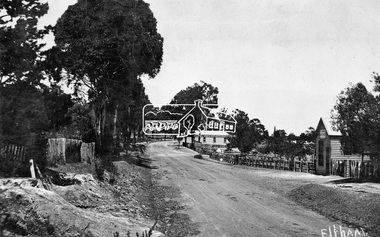
Negative - Photograph, Tom Prior, Main Road near Eltham Railway Station, c.1910
... View looking south along Main Road, Eltham from near... melbourne View looking south along Main Road, Eltham from near ...View looking south along Main Road, Eltham from near present day Luck Street. On the immediate right is a fence with the words “Hot Water” painted on it followed by William J Capewell’s butcher shop, then the slaughter yard and saleyards with the entrance access to the railway station. Contained within the saleyards facing the street, a small shelter with the name H.H. Clark upon it. Horace Harold Clark was the son of Eltham State School’s first Head Teacher, David George Clark. As well as being a farmer, he was an Estate Agent and conducted auction sales, presumably from this shelter. The large weatherboard building on the corner (opposite present-day Arthur Street) with signs for Summer Drinks and Hot Water painted on the side is Luther and Ada Haley’s General Store and Bakery, built 1902. This was the first building in what is now Eltham’s present shopping town centre. Haley previously ran the General Store and Bakery on the corner of Main Road and York Street until his lease expired and the premises were bought by Mrs Sarah Burgoyne in 1902. The store later was known as Staff's Store. In the distance approximately mid-way between the Butcher shop and the Bakery are the tops of what appears to be two cypress trees, which could well be the trees in front of the Shillinglaw Cottage facing Main Road. On the eastern (left) side of Main Street is Haley’s Paddock, which was used on occasions for community picnics. Capable of holding 10,000 people, with ample shade and hilly surroundings it was an ideal place for any community gathering such as the State Schools’ Picnic in 1904. Picture dated as c.1910 based on similar picture published in the Weekly Times, Feb. 1912. Kerb and channelling added 1923. Cross Ref: 610 (looking north), 611 (later stage), 613. Same as 705 (though in better condition)This photo forms part of a collection of photographs gathered by the Shire of Eltham for their centenary project book,"Pioneers and Painters: 100 years of the Shire of Eltham" by Alan Marshall (1971). The collection of over 500 images is held in partnership between Eltham District Historical Society and Yarra Plenty Regional Library (Eltham Library) and is now formally known as the 'The Shire of Eltham Pioneers Photograph Collection.' It is significant in being the first community sourced collection representing the places and people of the Shire's first one hundred years.Digital image 4 x 5 inch B&W Neg 120 format B&W negative (spare)shire of eltham pioneers photograph collection, eltham, main road, butcher, eltham railway station, railway station, w.j. capewell, baker, eltham town centre, general store, luther haley, reynolds prior collection, shops, haley's paddock, hot water, m.m. clark, sign, summer drinks, eltham sale yards, eltham slaughter yard, staffs general store -
Glen Eira Historical Society
Article - OUTER CIRCLE RAILWAY
... . One on Warrigal Road, looking south from Ashburton dated 1936... Road, looking south from Ashburton dated 1936. The second ...This file contains five items: 1/Two copies of a document titled THE OUTER CIRCLE RAILWAY by the Royal Historical Society of Victoria and the Australian Railway Historical Society, Vic div. It details the history of the construction of the Outer Circle Railway and discussed expenses and other factors affecting the construction of the line. Notes compiled by R.K Whitehead, Research and Archives Officer Australian Railway Historical Society Victoria Division. The document includes three maps of the outer circle railway line. 2/Four newspaper articles detailing the history of the Outer Circle Railway Line. They include ten black and white images of various aspects of the railway and three line maps. The first article is titled ‘Rail Link with the Past’. In the COLLINGWOOD COURIER dated 07/10/1970, author unknown. The second article titled ‘Ghost trains of the Outer’ by Kenneth Joachim in the HERALD dated 18/04/1975. The third article is titled ‘Tracks in Time’ by Norman Thompson from NEWS, dated 13/02/1973. The fourth article is titled ‘Our Ghost Railway’ by John Townsley from the HERALD, dated 06/11/1974. 3/A letter from Victorian Railways Chief Estate Officer N.A Wigmore to the Honorary Secretary of the Caulfield Historical Society, dated 19/11/1975 regarding the leasing of land along the Outer Circle Railway Reserve from Dandenong Road to the Hughesdale Station. 4/Two copies of an article titled ‘Outer Circle Railway’ in the CAULFIELD HISTORICAL SOCIETY NEWSLETTER undated detailing the history of the outer circle line. The article includes a map of the section of the line in Caulfield. 5/A Photocopy of two images of train line locations on the Outer Circle Line. One on Warrigal Road, looking south from Ashburton dated 1936. The second is of the Black Bridge over Gardiners Creek dated 1935.outer circle railway, normanby road, caulfield station, outer circle line, rosstown junction railway, monash john, caulfield historical society, poath road, deepdene dasher, ashby dasher, dandenong road, gippsy goods, mallee root mercury, outer circle railway reserve, railway lines, railway stations, steam trains -
 Ballarat Tramway Museum
Slide - 27 mm sq slide/s - set of 5, Lilian Butler, Sturt Street, 1971
... - Sturt St looking west, south side from Windermere St. .2 - ditto... - Sturt St looking west, south side from Windermere St. .2 - ditto ...Yields information about Sturt St between Lydiard St and Ripon St.Set of 5 AGFA slides - blue and white plastic mounts: 1 - Sturt St looking west, south side from Windermere St. .2 - ditto from Dawson St, shows tram stop sign and end of section sign. .3 - ditto from Armstrong St - with Myer's and Coles stores in the background. .4 - ditto at Ripon St, showing junction of View Point line, has the shelter on the right. .5 - City terminus - Sturt St and Lydiard St, with a bogie tram arriving from Grenville St. Has the ESCo switch box in the view - (to the right of the ladies). Has the Commonwealth Bank on the right hand side of the photo. Photo from the collection of Lilian Butler. ballarat, tramways, trams, sturt st, dawson st, tram stops, view point, shelters, lydiard st -
 Eltham District Historical Society Inc
Photograph, Eltham, Main Road near station, c.1910
... Times, Feb. 1912. Cross Ref: 609 (looking south), 612, 611... Times, Feb. 1912. Cross Ref: 609 (looking south), 612, 611 ...View looking north along Main Road, Eltham from near present day Dudley Street. On the immediate left is the railway station. The large weatherboard building on the bend (opposite present-day Arthur Street) with signs for General Store, Refreshments and Summer Drinks painted on the side is Luther and Ada Haley’s General Store and Bakery, built 1902. This was the first building in what is now Eltham’s present shopping town centre. Haley previously ran the General Store and Bakery on the corner of Main Road and York Street until his lease expired and the premises were bought by Mrs Sarah Burgoyne in 1902. The store later was known as Staff's Store. Followed by the saleyards, entrance to station, slaughter yard and William J Capewell’s butcher shop. Contained within the saleyards facing the street, a small shelter with the name H.H. Clark upon it. Horace Harold Clark was the son of Eltham State School’s first Head Teacher, David George Clark. As well as being a farmer, he was an Estate Agent and conducted auction sales, presumably from this shelter. On the eastern (right) side of Main Street is Haley’s Paddock, which was used on occasions for community picnics. Capable of holding 10,000 people, with ample shade and hilly surroundings it was an ideal place for any community gathering such as the State Schools’ Picnic in 1904. A worker from the bakery store is standing in the gateway at the rear of the store observing the photographer. People in the ‘Sunday Best’ are milling in front of the bakery or strolling down the centre of Main Road. The picture was most likely taken on a Sunday. With the opening of the railway to Eltham in 1902, Melbourne residents would regularly enjoy a Sunday excursion journey on the train to Eltham for a day’s outing to the countryside or beyond to Hurstbridge from 1912 when the railway was extended. Picture dated as c.1910 based on similar picture published in the Weekly Times, Feb. 1912. Cross Ref: 609 (looking south), 612, 611 (later stage), 613.This photo forms part of a collection of photographs gathered by the Shire of Eltham for their centenary project book,"Pioneers and Painters: 100 years of the Shire of Eltham" by Alan Marshall (1971). The collection of over 500 images is held in partnership between Eltham District Historical Society and Yarra Plenty Regional Library (Eltham Library) and is now formally known as the 'The Shire of Eltham Pioneers Photograph Collection.' It is significant in being the first community sourced collection representing the places and people of the Shire's first one hundred years.Digital image (4 x 5 inch negative missing - scanned from print) Printbaker, eltham, eltham railway station, general store, haley's paddock, luther haley, luther haley general store, main road, shire of eltham pioneers photograph collection, sign, summer drinks, butcher, railway station, w.j. capewell, eltham town centre, hot water, m.m. clark, eltham sale yards, eltham slaughter yard, staffs general store -
 Eltham District Historical Society Inc
Negative - Photograph, Eltham, Main Road near station, c.1910
... Times, Feb. 1912. Cross Ref: 609 (looking south), 612, 611... Times, Feb. 1912. Cross Ref: 609 (looking south), 612, 611 ...View looking north along Main Road, Eltham from near present day Dudley Street. On the immediate left is the railway station. The large weatherboard building on the bend (opposite present-day Arthur Street) with signs for General Store, Refreshments and Summer Drinks painted on the side is Luther and Ada Haley’s General Store and Bakery, built 1902. This was the first building in what is now Eltham’s present shopping town centre. Haley previously ran the General Store and Bakery on the corner of Main Road and York Street until his lease expired and the premises were bought by Mrs Sarah Burgoyne in 1902. The store later was known as Staff's Store. Followed by the saleyards, entrance to station, slaughter yard and William J Capewell’s butcher shop. Contained within the saleyards facing the street, a small shelter with the name H.H. Clark upon it. Horace Harold Clark was the son of Eltham State School’s first Head Teacher, David George Clark. As well as being a farmer, he was an Estate Agent and conducted auction sales, presumably from this shelter. On the eastern (right) side of Main Street is Haley’s Paddock, which was used on occasions for community picnics. Capable of holding 10,000 people, with ample shade and hilly surroundings it was an ideal place for any community gathering such as the State Schools’ Picnic in 1904. A worker from the bakery store is standing in the gateway at the rear of the store observing the photographer. People in the ‘Sunday Best’ are milling in front of the bakery or strolling down the centre of Main Road. The picture was most likely taken on a Sunday. With the opening of the railway to Eltham in 1902, Melbourne residents would regularly enjoy a Sunday excursion journey on the train to Eltham for a day’s outing to the countryside or beyond to Hurstbridge from 1912 when the railway was extended. Picture dated as c.1910 based on similar picture published in the Weekly Times, Feb. 1912. Cross Ref: 609 (looking south), 612, 611 (later stage), 613.Negative black and white film 120 6x9 format 2 stripsAgfa APX 100baker, butcher, eltham, eltham railway station, eltham sale yards, eltham slaughter yard, eltham town centre, general store, haley's paddock, hot water, luther haley, luther haley general store, m.m. clark, main road, railway station, shire of eltham pioneers photograph collection, shops, sign, staffs general store, summer drinks, w.j. capewell -
 Ballarat Tramway Museum
Photograph - Digital image, 1930
... of a postcard - titled "Sturt St Ballarat", looking east along the south... Ballarat", looking east along the south side of Sturt St from ...Yields information the buildings, buildings and scene in Sturt St looking East from Doveton St.Digital image from the Wal Jack Ballarat Album of a postcard - titled "Sturt St Ballarat", looking east along the south side of Sturt St from Dawson St. Tram in the far distance. Has a number of motor vehicles in the photograph. No details of the manufacturer on the back of the photograph - see image i2.trams, tramways, esco, sturt st, dawson st -
 Ballarat Tramway Museum
Album - Photo Album, c1970
... at the reserved track 14. - Lydiard St North looking south .15 - 42... at the reserved track 14. - Lydiard St North looking south .15 - 42 ...Set of 16 photos of Ballarat tram system taken 1970c on a tour by an unknown Qld based person.Photo album containing 16 colour prints. Photo album has heavy card covers, covered in black textured plastic containing 12 clear plastic photo sleeves held with a white comb binder. Photos of Ballarat prior to closure, c1970. Photographer unknown. Donated by Peter Hyde of Brisbane Tramway Museum to BTM 3/2/2010, from a deceased estate. Photos apparently taken on a tram tour. .1 - No. 42 and a single trucker inbound in Sturt St. .2 - taken from tram ascending Bakery St hill in Victoria St. .3 - End of No. 42, with the destination "Haddon St via Drummond Nth" .4 - No. 11 and 42 in Lydiard St Nth, near the railway station. No. 11 showing special. .5 - photo of three people on the tour. .6 - Trams reversing at the Victoria St terminus .7 - ditto .8 - 11, 42 and 12? in Lydiard St North by railway station. .9 - Three trams at Sebastopol terminus. .10 - View in Albert St Sebastopol looking north along the track on the side of the road. .11 - View of the tram crossing in Albert St. .12 - 27 and 42 crossing Albert St Sebastopol. .13 - View of Albert St from the tram, north of the crossing looking at the reserved track 14. - Lydiard St North looking south .15 - 42 at the railway level crossing. .16 - View south of the railway level crossing, three trams, with passengers alighting.trams, tramways, ballarat, albert st, sebastopol, victoria st, sturt st, lydiard st nth, railway crossing -
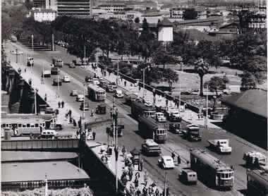 Melbourne Tram Museum
Photograph - Black & White Photograph/s, Australian Govt. Department of Information, late 1940's
... Melbourne, looking south over Princes Bridge, early 1950's. Has... Cathedral Melbourne, looking south over Princes Bridge, early 1950's ...Black and white photograph taken from St Pauls Cathedral Melbourne, looking south over Princes Bridge, early 1950's. Has nine trams in the view, mainly W2's, but one W3 and many motor vehicles, trucks etc. Shows the gardens in the now Southbank area, the junction just past the bridge of South Melbourne tram line, Wirth Bros Circus and other buildings, Prince Henry's Hospital. In particular is an Olympic pool direction sign hanging below the Batman Ave tram sign. This would have been the pool in Batman Ave, nearer to Flinders St, within the Flinders St yard complex, not the 1956 pool. Directly below is a female pedestrian dress in the classic 1950's "Dior" look. Over the bridge on the west side is "The Trocadero" formerly The Green Mill Dance Hall opened on 07/09/1926. West of that again is "Olympia" run by Wirth's . In the distance is Prince Henry's Hospital, the tall section was built in 1942, since demolished. Rod Atkins noted that the Olympia burnt down in the early fifties about the same the Trocadia closed, so pre 1953. Note the centre pole is still place at the Sturt Street intersection. In Batman Ave we have two W2's 401 and earlier one. In St Kilda Road we have four W2's in foreground in then W3 - No. 667 then a W4 then a SW6 in the distance. Outbound on route 4D is 578, behind it is 340 on route 5. A safety zone is between 578 and 340.Stamped on rear "Australian Official Photograph / Department of Information" and the number "L3121" in pencil.trams, tramways, swanston st, princes bridge, melbourne, south melbourne, tram 401, tram 667, tram 578 -
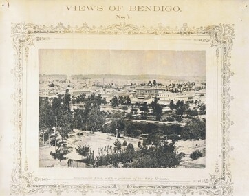 Bendigo Historical Society Inc.
Photograph - NICHOLAS CAIRE VIEWS OF BENDIGO
... looking south west. 39) View of the railway tunnel through the Big...) View from St. Paul's tower looking south west. 39) View ...Full set (52 photos) of Nicholas Caire ''Views of Bendigo'' photographs. 1) Sandhurst East with a portion of the City Reserve. 2) New Chum line of reef. 3) Sandhurst-North part as seen from the top of the Masonic Hall. 4) The Hustler's line of reef seen from Redan Hill. 5) Battery of stampers for crushing quartz 6) View of Sandhurst as seen from the top of the New Masonic Hall. 7) Excavation of quartz reef near Ironbark Hill. 8) St. Paul's Church, tower and belfry. 9) View of the Camp Reserve as seen from the Court House. 10) View of North Old Chum showing surface excavations. 11) View as seen from the Camp Hill near the lodge. 12) Garden Gully amalgamated claims. 13) Shamrock Hotel, Sandhurst. 14) View as seen from Court House showing the willows & East Pall Mall. 15) Wesleyan Church, Golden Square. 16) Savings bank, Sandhurst. 17) The Bendigo district hospital. 18) Interior of the Wesleyan Church, Golden Square. 19) View of Golden Square township. 20) The Town Hall, City of Sandhurst. 21) The City Hotel, Sandhurst. 22) Pall Mall, Sandhurst. 23) Sandhurst City Market. 24) Pall Mall, Sandhurst looking west. 25) View from Camp Hill looking north - east 26) View of Charing Cross, Sandhurst. 27) View of Sandhurst as seen from Knipe's Castle. 28) Township of Long Gully. 29) View taken from St. Paul's tower. 30) View of the Sandhurst cemetery at back creek. 31) Kock's pioneer quartz crushing plant, Long Gully. 32) The New Masonic Hall, Sandhurst. 33) The Bendigo benevolent asylum and industrial school. 34) Bendigo flat as seen from Wattle Hill. 35) View of Old Chum Hill. 36) New Chum Gully as seen from Specimen Hill. 37) Township of Eaglehawk. 38) View from St. Paul's tower looking south west. 39) View of the railway tunnel through the Big Hill, near Mt. Herbert. 40) View taken from St. Paul's looking south. 41) Scene taken from St. Paul's tower looking eastward. 42) View of Sandhurst from St. Paul's tower looking north-west. 43) The great extended Hustler's co's. quartz mining claim. 44) View from the Big Hill showing the line of railway to Melbourne. 45) View from St. Paul's Church tower looking westward. 46) View from St. Paul's Church tower looking north-west. 47) Scene near the Big Hill ranges taken from Mr. Buick's residence. 48) View from St. Paul's Church tower looking north eastward. 49) Township of Eaglehawk 50) View of Mitchell Street, Sandhurst. 51) Botanical gardens near the White Hills. 52) View Point, Sandhurst.bendigo, streetscape, various views, nicholas cairne -
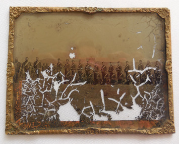 Flagstaff Hill Maritime Museum and Village
Photograph - Glass plate, circa 1860
... from a vantage point and looked south to south-east, the hills... from a vantage point and looked south to south-east, the hills ...This glass plate photograph shows good detail of uniformed and armed members of the early Volunteer Corps posing for their photograph in front of a young township. There are other well-dressed citizens behind them. Perhaps this was a special ceremony or event. It is likely that the subject of the photograph was the Warrnambool Volunteer Rifle Corps from Warrnambool in the 1860s if the following assumptions are made - - The Warrnambool Volunteer Rifle Corps was established in 1858 - the firearms held appear to be 1853 pattern Lee Enfield muskets used by the British army in Crimea at this time and in Australia, rather than the later Martini Henry cartridge rifles - The uniforms match other photos of the Warrnambool Garrison Militia and Band in our Collection, taken up until the 1880s - The three storey building in the photograph is alike to Warrnambool’s Manifold & Bostock flour mill, built in 1854 near the ‘cutting’ in Merri Street, which was one of the main streets at the time. If one faced the building’s front from a vantage point and looked south to south-east, the hills around Flagstaff Hill and Cannon Hill would be behind that mill, and the Harbour behind the hills. This is the area of the Fortifications - The glass plate method of photography was widely used during the mid-19th to early-20th century - The donor of the photograph is unknown but most likely to be a local family member Around this time the citizens of Victoria were prospering from the gold rush but felt isolated and uneasy about their security in the colony. In 1854 the Volunteer Act was passed to provide some military defence. In 1858 the Warrnambool Volunteer Rifle Corps was established, disbanded in 1863, then a new Warrnambool Detachment was formed in September 1866. Legislation was passed in 1884 that replaced the volunteers’ corps with a partly paid, permanent Militia Defence Force. The batteries manning the coastal forts of Victoria were termed Garrison Artillery Companies. When the Army was federated in 1901 there were eight Militia Companies in Victoria. Warrnambool and Port Fairy together were known as 8 Coy AGA (Australian Garrison Artillery). Changes to formation and name continued into the 20th century. This photograph is a record of the very early volunteer defence force in Victoria, showing the Militia Volunteers from the mid-19th century, likely to be the Warrnambool Volunteer Rifle Corps, which was established in 1858. The photograph signifies the connection of the colony in Victoria to the growing need for security due to the unrest in Europe at the time around the Crimean War. The photograph is also locally significant to the industry of the young township of Warrnambool, showing what is likely to be one of the first flour mills in the town. The photograph is also the only example of the early methods of glass plate photography in our collection. Photograph, rectangular glass plate, positive sepia image. Photograph has brass framed edges that fold over to the back with mitred corners. The front edges are pressed with a decorative floral pattern. The photograph shows a group of thirty military men, standing or kneeling, in dark uniforms with pillbox forage caps, round-collared jackets with light buttons, light sashes worn from top left shoulder to bottom right side of waist belt, and long, straight-legged trousers. Three of these men have light braid around the buttons on the front of their jackets, light frogging on their sleeve cuffs and stripes on the outside seams of their trousers. The other twenty-seven men have plain uniforms and are holding firearms in their right hands, steadied with their left hands. Other figures are standing behind this group of soldiers, including three or four men wearing top hats, jackets and ties. In the background is a row of buildings. The central building is three stories high. Bare hills are in the far background. The foreground is uneven ground with patches of short grass. flagstaff hill, warrnambool, shipwrecked coast, flagstaff hill maritime museum, maritime museum, shipwreck coast, flagstaff hill maritime village, great ocean road, glass plate, photography 19th century, colonial forces, military defence, volunteer act 1854, volunteer rifle, garrison artillery, volunteer corps, militia, militia garrison band, pillbox forage caps, 8 coy aga (australian garrison artillery), 1860, helpmann, manifold and bostock, 1853 lee enfield musket, tintype -
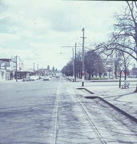
 Federation University Historical Collection
Photograph - Colour, ANZAC Dawn Remembrance During the Covid-19 Pandemic, 2020, 25/04/2020
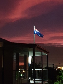
... Armstrong Street South, Ballarat looking East towards Mount... remembrance from Armstrong Street South, Ballarat looking East towards ...On 12 January, the World Health Organization (WHO) confirmed that a novel coronavirus was the cause of a respiratory illness in a cluster of people in Wuhan City, Hubei Province, China, who had initially come to the attention of the WHO on 31 December 2019. On 3 March, the Reserve Bank of Australia became the first central bank to cut interest rates in response to the outbreak. Official interest rates were cut by 0.25% (25 base points) to a record low of 0.5%. On 12 March, the Federal Government announced a A$17.6 billion stimulus package, the first since the 2008 GFC. he package consists of multiple parts, a one-off A$750 payment to around 6.5 million welfare recipients as early as 31 March 2020, small business assistance with 700,000 grants up to $25,000 and a 50% wage subsidy for 120,000 apprenticies or trainees for up to 9 months, 1 billion to support economically impacted sectors, regions and communities, and $700 million to increase tax write off and $3.2 billion to support short-term small and medium-sized business investment. On 16 March, Premier Dan Andrews and Minister for Health Jenny Mikakos declared a state of emergency for Victoria for at least four weeks. On 19 March, the Reserve Bank again cut interest rates by a further 0.25% to 0.25%, the lowest in Australian history. On 22 March, the government announced a second stimulus package of A$66bn, increasing the amount of total financial package offered to A$89bn. This included several new measures like doubling income support for individuals on Jobseeker's allowance, granting A$100,000 to small and medium-sized businesses and A$715 million to Australian airports and airlines. It also allowed individuals affected by the outbreak to access up to A$10,000 of their superannuation during 2019–2020 and also being able to take an additional same amount for the next year. on the same day Victorian Premier Daniel Andrews announced on 22 March that the state will bring the school holiday forwards to 24 March from 27 March. On 30 March, the Australian Federal Government announced a $130 billion "JobKeeper" wage subsidy program offering to pay employers up to $1500 a fortnight per full-time, part-time or casual employee that has worked for that business for over a year. For a business to be eligible, they must have lost 30% of turnover after 1 March of annual revenue up to and including $1 billion. For businesses with a revenue of over $1 billion, turnover must have decreased by 50%. Businesses are then required by law to pay the subsidy to their staff, in lieu of their usual wages. This response came after the enormous job losses seen just a week prior when an estimated 1 million Australians lost their jobs. This massive loss in jobs caused the myGov website to crash and lines out of Centrelink offices to run hundreds of metres long.The program was backdated to 1 March, to aim at reemploying the many people who had just lost their jobs in the weeks before. Businesses would receive the JobKeeper subsidy for six months. On 2 April, the number of cases in Victoria exceeded 1,000, including over 100 healthcare workers. On 5 April, New South Wales Police launched a criminal investigation into whether the operator of Ruby Princess, Carnival Australia, broke the Biosecurity Act 2015 (Cwth) and New South Wales state laws, by deliberately concealing COVID-19 cases. On 6 April, the Department of Health revealed that 2,432 people recovered from the infection as the federal government started reporting recovery statistics. This is more than a third from the official number reported so far, Deputy Chief Medical Officer Professor Paul Kelly stating, "I think it is important. Firstly it really reinforces that message, which is a true one, that most people who get this disease do recover”. The day before, at 3pm, it was announced that 2,315 of the 5,687 confirmed coronavirus cases had recovered. May 2020 - An outbreak in Victoria at a meatworks that was later revealed to be Cedar Meats was announced on 02 May with eight cases. By 8 May, the cluster of cases linked to Cedar Meats in Victoria was 71, consisting of at least 57 workers and 13 close contacts, including a nurse, aged care worker and high school student. The number had increased to 75 by 9 May, 88 by 13 May, and 90 by 14 May. On 9 May, two Victorian cases were announced to be related to McDonald's Fawkner. By 18 May, this had increased to 12 cases, and on that day it was revealed that a delivery driver had tested positive, prompting the closing for cleaning of 12 more McDonald's locations: Melton East, Laverton North, Yallambie, Taylors Lakes, Campbellfield, Sunbury, Hoppers Crossing, Riverdale Village, Sandown, Calder Highway Northbound/Outbound, Calder Highway Southbound/Inbound, and BP Rockbank Service Centre Outbound. On 15 May, South Australia became the second jurisdiction, after the ACT, to be free of any active cases, however on 26 May, a woman returning from overseas who was granted exemption into South Australia from her hotel quarantine in Victoria tested positive for COVID-19. This was the first new case in 19 days for the state.[101] On 4 June, it was announced that the woman had recovered and the state was free of any active cases once again.[102] On 17 May, Victoria announced two further business sites had been shut down due to a suspected case at each. Domino's Pizza in Fairfield has been shut for two weeks, and mattress manufacturer The Comfort Group in Deer Park was closed from Friday 15 May to at least Wednesday 20 May. On 6 June, both New South Wales and Victoria reported no new cases for the previous 24 hours, with only Queensland and Western Australia reporting one new case each, the lowest national total since February. Western Australia also announced two old cases. However, the new case in Queensland was linked to the Rydges on Swanston cluster in Melbourne when a man who travelled from Melbourne to Brisbane on Virgin flight VA313 on 1 June tested positive.Colour photographs of an ANZAC dawn remembrance from Armstrong Street South, Ballarat looking East towards Mount Warrenheip. Due to the Covid-19 Pandemic and associated social distancing requirements regular ANZAC Day services and marches could not be held. People were encouraged to remember from their driveways at dawn on 25 April 2020. covid-19, corona virus, pandemic, social distancing, anzac day driveway remembrance, dawn, australian flag, mount warrenheip -
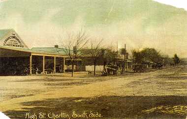 Charlton Golden Grains Museum Inc
Postcard, High St. Charlton, South Side
... on the south side looking west. Includes Foundry and residence, man... of hand coloured post card. Shows High St Charlton on the south ...Charlton Foundry 1907 owned and operated by Dabrons. Had 20-30 employees.Copy of hand coloured post card. Shows High St Charlton on the south side looking west. Includes Foundry and residence, man unloading a cart. Another wagon is in front slightly down the street. Road is unpaved. One of a set of postcards taken in 1907. Writing at the bottom of the card reads High St. Charlton, South Side.charlton foundry, dabron, high stcharlton -
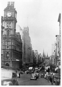 Melbourne Tram Museum
Photograph - Black and White - Bourke St early 1950s
... Photograph, from a publication, of Bourke St looking east... Photograph, from a publication, of Bourke St looking east from ...Photograph, from a publication, of Bourke St looking east from the south side between Queen and Elizabeth Streets. The cable tram tracks can be seen in the street pavement. Has many double deck and some single deck buses. Very busy and congested traffic scene between Elizabeth and Swanston Streets. In the view are the General Post Office, the Myer Store, Foys, Parliament House and London Stores.Yields information about Bourke Street prior to conversion to electric trams.Black and white photograph of Bourke St looking east early 1950'stramways, mmtb, buses, double deck buses, bourke street, cable trams, traffic