Showing 1315 items matching "looking west"
-
 Ballarat Heritage Services
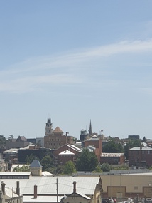
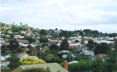
Photograph - Colour, Ballarat from the Former Humffray Street State School, 2019, 11/01/2019
... A number of photographs looking over Ballarat West from... of photographs looking over Ballarat West from the second storey ...A number of photographs looking over Ballarat West from the second storey of the former Humffray Street State School.ballarat, humffray stree state school -
 Canterbury History Group
Photograph - Building Bradshaws Maling Service Station, 1969
... on Bradshaws Maling Service Station, from the west looking east, 1969... Maling Service Station, from the west looking east, 1969 ...Black and white photograph of construction work on Bradshaws Maling Service Station, from the west looking east, 1969canterbury, maling road, d.h.bradshaw auto service pty ltd, petrol stations, canterbury railway station, theatre place, shops -
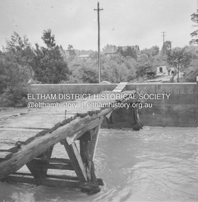
 Eltham District Historical Society Inc
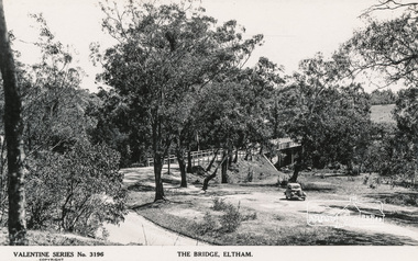
Postcard - Photograph, The Rose Stereograph Company, The Bridge, Eltham, c.1939
... Looking west across the Main Road Bridge over the Diamond... melbourne Looking west across the Main Road Bridge over the Diamond ...Looking west across the Main Road Bridge over the Diamond Creek at Eltham, c.1939. The car in the foreground, possibly the photographer's, is a Ford Model C Ten built by Ford UK between 1934 and 1937. The Model C was released in Australia in 1935. The Ford Model C Ten is a car that was built by Ford UK between 1934 and 1937. The Model C was released in Australia in 1935 https://en.wikipedia.org/wiki/Ford_Model_C_TenPostcardValentine Series No.3196diamond creek (creek), ford model c ten, main road bridge, postcard, valentine series postcard, bridge, cars, eltham, eltham south, main road, motor vehicles, rose stereograph, rose stereograph company -
 Ballarat Tramway Museum
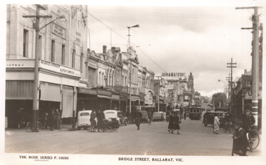
Postcard, Rose Stereograph Co, "Bridge Street, Ballarat Vic.", late 1930s
... to Mt Pleasant. The photo is of Bridge St looking west from... is of Bridge St looking west from Peel St. In the photo are a butcher ...The photo shows tram 12 in Bridge St Ballarat on its way to Mt Pleasant. The photo is of Bridge St looking west from Peel St. In the photo are a butcher, a newsagent, a sign "Join ANA Today", along with two ladies with prams crossing the road. Wal Jack on the rear of the photo notes it is about 1940. Based on the cars in the photo, late 1930s. Item 5463 has a poor quality negative of this postcard. Yields information about Bridge St Ballarat during the late 1930sPostcard black and white, divided back, with a handwritten note on rear.See image 2 for details of the handwritten note by Wal Jack on the rear. tramways, trams, bridge st, tram 12 -
 Ballarat Tramway Museum
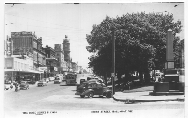
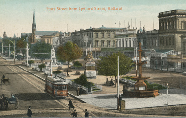
Postcard, Rose Stereograph Co, "Sturt Street, Ballarat", c1960
... along the south side of Sturt St from Grenville St looking west... along the south side of Sturt St from Grenville St looking west ...Postcard - titled "Sturt St Ballarat Vic" showing the view along the south side of Sturt St from Grenville St looking west. Has tram No. 12 in the view, part way fitted with dash canopy lighting - c1960. In the view are the 8-hour monument, the T&G building, the Mechanics Institute advertising Davies Bread and Robur Tea, the Odeon Theatre, the National Mutual building, and the Town Hall. Yields information the buildings, buildings and scene along Sturt St from Grenville St.Postcard printed by Kodak and a copy photograph of Rose Stereograph Co. postcard, No P 13491 with trimming marks along the top edge.ballarat, trams, tramways, sturt st, town hall, tram 12 -
 Melbourne Tram Museum
Postcard, "A Glimpse of Collins St Melbourne Victoria", mid 1900's?
... Image of Collins St looking west from Russell St with two...Image of Collins St looking west from Russell St with two ...Image of Collins St looking west from Russell St with two cable trams in the view. Includes the Town Hall. Printed mid-1900's. Titled "A Glimpse of Collins St Melbourne Victoria". On the rear is a handwritten message and address - the removal of the stamp has obscured name. No printer details other than a number "B135/841" and in the bottom right hand corner "No. 8". Second copy in good order.Yields information about Collins St eastern end.Divided back postcard featuring a coloured image - Two copies held.trams, tramways, collins st, cable trams, town hall -
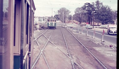
 Ballarat Tramway Museum
Slide - 35mm slide/s, David Verrier, 6/10/1964 12:00:00 AM
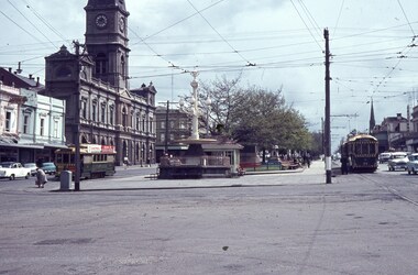
... by David Verrier of looking west at the intersection of Sturt... blue plastic mount. Photograph by David Verrier of looking west ...Yields information about the appearance of the City Centre tramway area, and the tram services that ran from there.Agfa colour slide, white blue plastic mount. Photograph by David Verrier of looking west at the intersection of Sturt and Lydiard St with trams 28 (south side)( Gardens), and on the north side tram 34 (Mt Pleasant) and behind it No. 40 (Lydiard St North). Has the Town Hall, tram stop shelter and the fountain in the view. Note the traction power electrical box on the corner with an elderly lady about to cross the road. Photo taken 6/10/1964.On back of slide in pencil "Tues 6/10/64 Ballarat, Sturt and Lydiard St, RT 34 Mt Pleasant, 40 Lydiard Nth LT 28 Gardens"tramways, trams, sturt st, tramway centre, lydiard st, town hall, tram 34, tram 40, tram 28 -
 Ballarat Tramway Museum
Badge - 1918 Ballarat Christian Convention badge, Sept. 2018
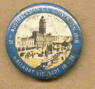
... looking west from the Post Office, with an ESCo tram and ex horse... Convention badge. Has an image of Sturt St looking west from the Post ...Has a strong association with a Church of England Convention in 1918, shows a scene of Sturt St Ballarat with a tram. Would have acted as a souvenir of the convention.Button badge, 32diameter, plastic back, metal image front, green border, pressed on with steel spike pin, for the 1918 Ballarat Christian Convention badge. Has an image of Sturt St looking west from the Post Office, with an ESCo tram and ex horse tram trailer in the bottom section of the badge. Has words "12th Australasian C.E. Convention 1918 Ballarat Vic. Sept 18 - 26" See also Reg Item 3361 for another version of the same convention badge.tramways, trams, badges, conferences, christian, esco -
 Ballarat Tramway Museum
Badge - 1918 Ballarat Christian Convention badge, Sept. 2018
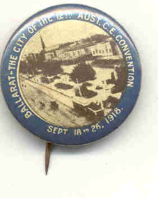
... looking west from the Town Hall, with an ESCo tram and ex horse... Convention badge. Has an image of Sturt St looking west from the Town ...Has a strong association with a Church of England Convention in 1918, shows a scene of Sturt St Ballarat with a tram. Would have acted as a souvenir of the convention.Button badge, 32diameter, plastic back, metal image front, green border, pressed on with steel spike pin, for the 1918 Ballarat Christian Convention badge. Has an image of Sturt St looking west from the Town Hall, with an ESCo tram and ex horse tram trailer in the bottom section of the badge. Has words "Ballarat - The City of the 12th Aust C.E. Convention Sept18 - 26 1918" See also Reg Item 4005 for another version of the same convention badge.tramways, trams, badges, conferences, christian, esco -
 Ballarat Tramway Museum
Photograph - Black & White Photograph/s, c1895
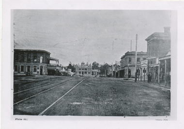
... a view along High St Eaglehawk, looking west, c1895. Shows..., looking west, c1895. Shows buildings on both sides of the street ...Black and White copy print contained within the Wal Jack Bendigo and Geelong Album, see Reg Item 5003 for more details. Copy photograph of a photograph from a book (Plate 1) showing a view along High St Eaglehawk, looking west, c1895. Shows buildings on both sides of the street. Has name J. Nimmon? or Ninnis (see btm 4372) in the bottom right hand corner. See also Reg item 5729 for a similar photograph. .1 - On rear in ink "Steam track tracks, Eaglehawk. (So much for the AETA boys who believe steam service did not cross the railway on the level!). In bottom right hand corner is "P. W. Duckett" trams, tramways, bendigo, high st, eaglehawk, steam trams -
 Ballarat Tramway Museum
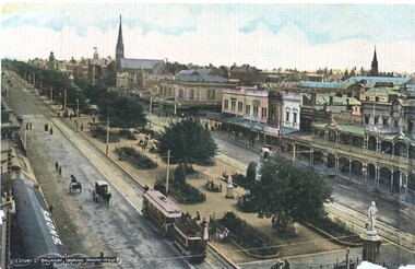
Postcard, Litho Coy and Ballarat, Sturt Street from the Town Hall Clock tower, c1900
... Postcard - looking north west from the Town Hall clock.... Postcard - looking north west from the Town Hall clock tower, c1905 ...Yields information about the operation of horse tram trailers behind electric trams and the appearance of Ballarat Sturt St c1906.Postcard - looking north west from the Town Hall clock tower, c1905 - 06 - with an ESCo electric tram hauling a loaded ex horse tram trailer. Has the Snows and the buildings on the north side of Sturt St in the view, including Anderson Morse Coach builders. Has the title "Sturt St Ballarat looking North West" in the bottom left hand corner. On the rear - divided back type with space for stamp, address and correspondence and the printer's name "Litho Coy, Ballarat". "$16" in stamp position in pencil.trams, tramways, sturt st, trailers, horse trams, esco -
 Ballarat Tramway Museum
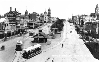
Photograph - Black & White Photograph/s, c1910
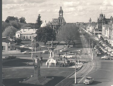
... looking west from Grenville St along Sturt St Ballarat. Has four..., digital print, of a view looking west from Grenville St along ...Yields information about the east end of Sturt St showing a number of tramcars, the shelter and the street scene.Black and white photograph, digital print, of a view looking west from Grenville St along Sturt St Ballarat. Has four ESCo trams in the view, 20, 11, 13 and 9? Photo shows the large ESCo waiting shelter with the weighing machine. Adjacent to the shelter in the median strip is the 8 hour monument. Has a number of horse drawn vehicles, bicycles and a few pedestrians. In the view are the Suttons building, Town Hall, Courier and Star Office. Photo taken c1910.trams, tramways, grenville st, sturt st, esco, shelters, tram 20, tram 11, tram 13, tram 9? -
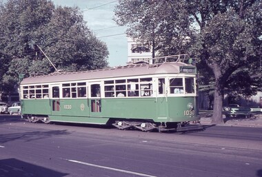
 Ballarat Tramway Museum
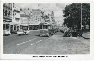
Photograph - Digital image, Murray Views, Murray Views No. 20 - Sturt Street, Ballarat Vic.", 1960
... of Sturt St. looking west from Grenville St with a number of trams... the appearance of Sturt St looking towards the Town Hall from Grenville ...Yields information about the appearance of Sturt St looking towards the Town Hall from Grenville StDigital image from the Wal Jack Ballarat Album of Photo of Sturt St. looking west from Grenville St with a number of trams parked in City Loop - No. 40 is the last tram - conversion to the zebra stripes has commenced, but the lights are yet to be fitted. Dates the photo as 1960/61. Murray Views Photo No. 20. In the photo are Hartleys, Patersons, T&G and Odeon buildings and adverts for Davies Bread and Robur Tea. See image i2 for rear of photograph. trams, tramways, sturt st, city loop, tram 40 -
 Ballarat Tramway Museum
Photograph - Digital image, Valentine & Sons Publishing Co, 1910
... of a coloured postcard looking west from Lydiard St along Sturt St... looking west from Lydiard St along Sturt St with ESCo No. 17 ...Yields information the appearance of Sturt St from Lydiard St about 1910 with ESCo trams in the photograph.Digital image from the Wal Jack Ballarat Album of a coloured postcard looking west from Lydiard St along Sturt St with ESCo No. 17 at the city tram terminus. Has good detail of the central median strip. In the background is the Art Gallery Association building, Crockers store. c1910. Has the number 300ATR in the bottom right hand corner. Published by Valentines & Sons Publishing Co. Ltd. Melbourne and Sydney. Printed in Great Britain. For rear of postcard - see image i2.trams, tramways, sturt st, esco, lydiard st, tram 17 -
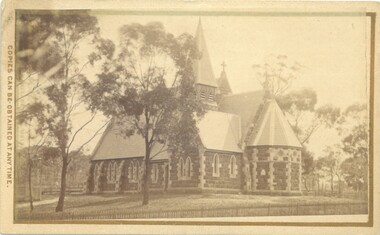 Bacchus Marsh & District Historical Society
Photograph, Holy Trinity Church Bacchus Marsh 1883
... Marsh. The view of the building is from Gisborne Road looking... looking west. From this angle the rear and southern side ...The Holy Trinity Anglican Church in this location was first opened in 1877. An earlier nearby prefabricated Church building known as the 'Iron Church' had served as the Anglican place of worship in Bacchus Marsh from around 1855 until 1877. The 1877 sandstone Church with a slate roof was intended as a permanent structure for Anglican worship in Bacchus Marsh and still stands in 2024 and continues to function as an Anglican Church. The building was designed by Frederick Wyatt and is described as early English Gothic in style. It was opened on 5 June 1877 by Bishop Moorhouse of Melbourne. The sandstone was acquired from Grant's quarry at Maddingley.Small sepia unframed photograph on card with gold border framing photograph. Housed in the Jeremeas Family Album, which contains photographs of Bacchus Marsh and District in 1883 by Stevenson and McNicoll. The photograph depicts the recently constructed Anglican Holy Trinity Church in Gisborne Road, Bacchus Marsh. The view of the building is from Gisborne Road looking west. From this angle the rear and southern side of the building can be seen. A picket fence along the entrance to the Church grounds can be seen in the foreground.On the front: Stevenson & McNicoll. Photo. 108 Elizabeth St. Melbourne. COPIES CAN BE OBTAINED AT ANY TIME. On the back: LIGHT & TRUTH inscribed on a banner surmounted by a representation of the rising sun. Copies of this Portrait can be had at any time by sending the Name and Post Office Money Order or Stamps for the amount of order to STEVENSON & McNICOLL LATE BENSON & STEVENSON, Photographers. 108 Elizabeth Street, MELBOURNE churches bacchus marsh, holy trinity anglican church bacchus marsh, holy trinity church of england bacchus marsh, stevenson and mcnicoll 1883 photographs of bacchus marsh and district -
 Melbourne Tram Museum
Slide, Keith Caldwell, Mar. 1963
... / Spring St at the corner of Little Bourke St. looking west... St. looking west. The building with the trellised ...Agfa Colour slide, cardboard mount, by Keith Caldwell dated 16 March 1962 of W7 1030 in Nicholson St. Tram has destination of East Brunswick Blyth St., Route 96. Mal Rowe advised 10/9/2019 that: "The location is the corner of Nicholson / Spring St at the corner of Little Bourke St. looking west. The building with the trellised balconies was the Salvation Army Young Women's Hostel - which apparent lasted to 1984." The garden is now part of Parliament Station reserve.In ink:"16.3.62"trams, tramways, spring st, nicholson st, w7 class, east brunswick, tram 1030 -
 Melbourne Tram Museum
Slide - Set of 3, Keith Caldwell, March 1967?
... at the Queensway road and tram track construction .3 - ditto, looking west... at the Queensway road and tram track construction .3 - ditto, looking west ...Set of three Agfa colour blue white plastic mount slides, photo by Keith Caldwell of : .1 - W2 651 outbound on route 15 to St Kilda beach negotiating trackwork at the St Kilda Junction. .2 - view from Upton Road overpass looking east at the Queensway road and tram track construction .3 - ditto, looking west shows the St Kilda Road bridge section being constructed c early, possibly March 1967.1 - "BXBU" and on .3, .1 also has "MBR River" in ink.trams, tramways, st kilda rd, st kilda junction, w2 class, route 15, trackwork, queensway, tram 651 -
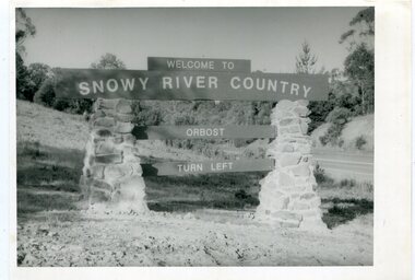 Orbost & District Historical Society
black and white photographs, second half 20th century
... looking west towards Orbost township"..., Orbost in front of Orbost High School looking west towards Orbost ...These photographs are pictorial records of the signs at the Orbost town entry points.Three black / white photographs. 3277.1 is a sign on stone pillars at the top of a hill - "WELCOME TO SNOWY RIVER COUNTRY ORBOST TURN LEFT". 3277.2 shows a road leading into a town. There is a sign on the left - "ORBOST" and a service station on the right. 3277.3 shows a row of newly planted trees between a road and a school.3277.1 on back - "WELCOME TO SNOWY RIVER COUNTRY - ORBOST sign - Princes Highway - Newmerella" 3277.2 on back - "East Gippsland Shire Sign on eastern approach to ORBOST., in Salisbury Street, near Orbost Secondary College" 3277.3 on back - "Tree planting in Salisbury St, Orbost in front of Orbost High School looking west towards Orbost township"photographs-orbost orbost-township-entry salisbury-street-trees town-entry road-signs-orbost -
 Bendigo Historical Society Inc.
Photograph - WES HARRY COLLECTION: PALL MALL, 1972
... tower looking north west along Pall Mall. Bottom centre... photograph taken from the City Family Hotel tower looking north west ...Black and white photograph taken from the City Family Hotel tower looking north west along Pall Mall. Bottom centre is the fountain and the cenotaph, top centre is the post office clock tower.Martin Washingtonplace, bendigo, pall mall, pall mall, fountain, cenotaph, post office, tram tracks, shamrock hotel -
 Federation University Historical Collection
Booklet, Back to Bacchus Marsh, 1930, 1930
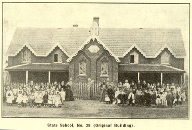
... * Bacchus Marsh Looking West, 1872 * Bacchus Marsh Looking West... Marsh looking east, 1930 * Bacchus Marsh Looking West, 1872 ...The 1930 Back to Bacchus Marsh celebrations were held on 23 to 28 October 1930. The committee were Cr L.M. Gugdale (president), A.W. Bond (General secretary), W. Grant Morton, J.G. Wells, Dr E. McDonald, Charles Dickie, G.H. Anderson, F.M. Crisp, W.R. Vigor. Bacchus Marsh State School No. 28 was established in 1851 as a National School in a rented building on the right-hand side of Bacchus Marsh-Melbourne Road, just beyond Woolpack Inn. Several willow trees mark the site. H.G. Ball was the first Head Teacher of the school, and the enrolmen towas 34. In 1854 Governor Charles Hotham visited the school. In 1855 two new schools, East and West, were recommended. School No. 28 closed in 1862 and the sitre was sold. The present school site was purchased in 1865 for 67 pounds. The cost of the building was 782 pounds. (Visions and Realisations, Vol 3., 1973) A clock purchased by public subscription was placed in the front of the building to the memory of scholars who served during World War One. (Back to Bacchus Marsh, 1930)Brown covered book of 44 pages. Contents include Bacchus Marsh and its soldiers, Red Cross, Lerderderg Gorge, Werribee Gorge, Lerderderg Park, Coimadai, Darely Firebrick Co., Myrniong, Underbank, Balliang, Rowsley, Parwan, schoosl, churches, Shire Council, Federal Milk Pty Ltd, Bacchus Marsh Milk, Old Maddingley Bridge Images include: * Bacchus Marsh looking east, 1930 * Bacchus Marsh Looking West, 1872 * Bacchus Marsh Looking West, 1930 * Aerial View of Bacchus Marsh Township looking east * Aerial View of Bacchus Marsh Township looking south * Bacchus Marsh Agricultural Society & Pastoral Society, 1893 (named), * Original Bacchus Marsh State School No 28 * Holy Trinity Bacchus Marsh * Bacchus Marsh Baptist Church * St Bernard's Catholic Church * Bacchus Marsh Methodist Church * St Andrew's Presbyterian Church Bacchus Marsh * View of Maddingley Park, showing Original Courthouse, 1890 * Werribee Gorge * Underbank Stud Farm * Ballarat State School Number 28. Signed 'C. Hodgson'bacchus marsh, maddingley, maddingley park, underbank, lerderderg park, coimadai, darely firebrick co., myrniong, balliang, rowsley, parwan, schoosl, churches, shire council, federal milk pty ltd, bacchus marsh milk, old maddingley bridge, police, police paddock, maddingley gates, crisp, mccormack, cain, harkness, howe, bence, mcdonald, mcfarlane, cosgrave, flagg, burnip, scott, lodge, cameron, vallance, bacchus marsh state school, bacchus marsh state school no 28., geology, r.w. thompson, lederderg gorge, weribee gorge, comadai, darley firebrick company -
 Port Fairy Historical Society Museum and Archives
Photograph
... East side of training walls looking to South West passage... looking to South West passage Trading walls south west passage ...East side of training walls looking to South West passageColoured photograph of View of south west passage with Norfolk Island pinetrading walls, south west passage -
 Bacchus Marsh & District Historical Society
Postcard, Main Street, Bacchus Marsh, circa 1950
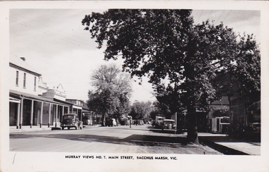
... Marsh dated around 1950. View is looking towards the West.... of Main Street, Bacchus Marsh dated around 1950. View is looking ...The Main Street of Bacchus Marsh underwent significant change from the early 1960s. Many older buildings began to be demolished after the early 1960s and into the 1980s. This view shows a central section of Main Street before this transformation took place. Produced as part of a series by the Murray Views Postcards and Souvenirs Company.Black and White postcard image of Main Street, Bacchus Marsh dated around 1950. View is looking towards the West.Murray Views No.7, Main Street, Bacchus Marsh, Vic.roads and streets bacchus marsh vic., main street bacchus marsh vic. -
 The Beechworth Burke Museum
Photograph, 1960
... , looking west across the lake. Lake Sambell is a beautiful... Sambell, looking west across the lake. Lake Sambell ...Taken in 1960, depicted is the construction of Lake Sambell, looking west across the lake. Lake Sambell is a beautiful Victorian recreation lake and urban park with a unique history. It was created in the mid-1800s by the Rocky Mountain Mining company during the gold rush era and used as a mining site until the early 1900s, which brought Europeans into the area. It was turned into a reserve for residents in 1920 and is considered an icon of Beechworth as it represents the development of the community, human endeavour, and the spirit of the landscape.This photograph represents additional construction to Lake Sambell as a recreational reserve.Black and white reproduced rectangular photograph print on paper.beechworth lake, lake, lake sambell, construction, #beechworth, australian landscape, beechworth 1960s, victoria -
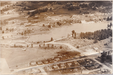
 Eltham District Historical Society Inc
Album - Photograph, J.A. McDonald, Eltham-Greensborough Road, 18 Oct. 1956
... October 1956 View looking west across the Diamond Creek... 18th October 1956 View looking west across the Diamond Creek ...Bridge Street Bridge Flood level on Greensborough pier 18th October 1956 View looking west across the Diamond Creek and tempoary walking access bridge towards intersection of Susan Street. The building visible on centreeline is the present-day SES facility. Beware!.. our rivers are rising (1956, October 19). The Argus (Melbourne, Vic. : 1848 - 1957), p. 1. Retrieved August 24, 2022, from http://nla.gov.au/nla.news-article84392304Record of various Shire of Eltham infrastructure works undertaken during the period of 1952-1962 involving bridge and road reconstruction projects, sometimes with Eltham Shire Council Project Reference numbers quoted. It was during this period that a number of significant improvements were made to roads and new bridges constructed within the shire that remain in place as of present day (2022). In many situations, the photos provide a tangible visible record of infrastructure that existed throughout the early days of the Shire. The album was put together by or under the direction of the Shire Engineer, J.A. McDonald.infrastructure, road construction, shire of eltham, bridge construction, bridge street bridge, eltham, eltham-greensborough road, 1956-10-18, diamond creek (creek), floods, floodwater, silver street bridge -
 Melbourne Tram Museum
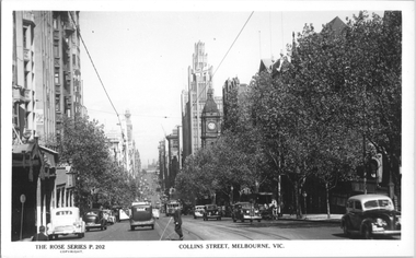
Postcard, Rose Stereograph Co, "Collins Street Melbourne", c1929
... , Melbourne" looking west from Russell Street. Has many trams in view..." looking west from Russell Street. Has many trams in view ...Rose Series postcard No. P 10765, titled "Collins Street, Melbourne" looking west from Russell Street. Has many trams in view, including tram 333 which does not have a route number box, though the one on the left side of the road does. This tram was fitted with a route number box during Nov. 1929. In the far background can be seen chimney stacks of the gas works. There is a sign for Martin and Pleasant, Homeopathic Pharmacy.Yields information about Collins St c1929Postcard - printed real photograph with Rose Stereograph Co. name on the rear.trams, collins st, w2 class, gas works, tramways, tram 333 -
 Ringwood and District Historical Society
Photograph, Westward view from Seymour Street along Charter Street, Ringwood - 1981
... across its junction with Seymour looking north-west. Staley... looking north-west. Staley Gardens on left. Telecom property ...Written on back of photograph, "1981, Charters Street from across its junction with Seymour looking north-west. Staley Gardens on left. Telecom property on right." -
 Ballarat Heritage Services
Photograph - Photograph - Colour, Lisa Gervasoni, Wombat Hill from West Street, Daylesford, 2000, 2000
... Colour photograph of Daylesford from West Street looking... West Street looking towards Wombat Hill. Wombat Hill from West ...Colour photograph of Daylesford from West Street looking towards Wombat Hill. daylesford, wombat hill -
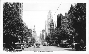
 Melbourne Tram Museum
Postcard, Rose Stereograph Co, "Collins Street Melbourne", late 1940s
... Melbourne" with a view from Russell St looking west. W2 class 574... Melbourne" with a view from Russell St looking west. W2 class 574 ...Rose Series postcard No. P 202, titled "Collins Street Melbourne" with a view from Russell St looking west. W2 class 574 (East Preston, route 9) is climbing the hill with another four W2's in the view as well. There is a horse-drawn delivery cart (milk? - Marche ?) parked on the north side of the street. 2 - Coloured postcard - does not have the company name on the rear. Only coloured Rose series seen as at 1/2025 by the Museum.Yields information about Collins St, late 1940sPostcard - printed real photograph with Rose Stereograph Co. name on the rear. Second copy has been coloured printed.tramways, collins st, tram 574, w2 class, trams -
 Ballarat Tramway Museum
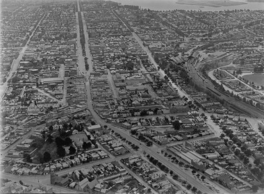
Photograph - Digital image, c1925
... Digital photograph of Ballarat looking West c1925, aerial... Ballarat c1925 from an aerial photograph looking west. Trams ...Yields information about Ballarat c1925 from an aerial photograph looking west.Digital photograph of Ballarat looking West c1925, aerial view, looking along Sturt St and Bridge St, taken from about Eureka and Kings St. Shows both the Alfred Hall, the Railway Station, Sunshine Biscuits and the Coliseum. Shows two single truckers at the east end of Sturt St and two at the west end of Bridge St or Grenville St. See email from Alan Bradley dated 28/7/2012 re date. See also Reg Item 5453 for another similar photograph.trams, tramways, ballarat, aerial views -
 Williamstown Botanic Gardens- Hobsons Bay City Council
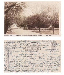
Postcard - Williamstown Botanic Gardens, circa 1900-1924
... A sepia scene looking west towards statue of Alfred Thomas... by ‘Margaret’. A sepia scene looking west towards statue of Alfred ...The original postcards in this series (2013.002 to 2013.018) were generously loaned to Williamstown Botanic Gardens by a private collector for copying. The postcards are evidence of the interest the gardens held as a subject for postcard publishers. The text and images provide a snapshot into fashions, social interests and concerns of the time. The professionally produced images provide a pictorial history of Gardens including changing planting styles, various structures and features of the Gardens eg the aviary, cannons, the fountain, the second Curator’s Lodge and gates. The images offer an opportunity to compare garden vistas with the present day. This postcard is evidence of the placement of two of the cannons relocated from Fort Gellibrand in 1906 and that they were in place in the Gardens in 1924. They were removed from the Gardens in the 1960s. These same cannons remain a feature on the Williamstown waterfront in 2013. The image also shows the original Elm Avenue plantings. A sepia scene looking west towards statue of Alfred Thomas Clark, with cannons on either side of statue pointing east down what is known as the Palm Avenue. The statue is surrounded by a white fence consisting of posts and a top rail. The top of the statue is hidden by the branches of the elm trees. It appears that the elms are in the process of either losing their leaves or new leaf growth. A cactus plant can be seen beneath the lower branches of the elm tree of the right closest to the camera. The cannons were moved from Fort Gellibrand to the Gardens in 1906.Front: VALENTINE’S, M.356 ELM AVENUE WILLIAMSTOWN GARDENS MELBOURNE, VICTORIA. REAL PHOTO. Reverse: vertical on left side of card and underlined: ‘Published by the Valentine & Sons Publishing Co. Ltd. / Melbourne, Sydney & Brisbane’. Top centre of card: Contains logo of ‘VALENTINES / REAL PHOTO SERIES / POSTCARD’. Top right hand corner is stamped ‘BRANCHES (enclosed in a scroll) / SYDNEY / LONDON / DUNDEE / DUBLIN / CAPETOWN / MONTREAL / TORONTO’ The card is dated ‘29/12/24’ and addressed to ‘Dear Leah Alf & Dad’ signed by ‘Margaret’. postcard, gardens, post-card, williamstown-botanic-gardens, hobsons-bay-city-council, statue, clarke, alfred-thomas-clarke, cannon, elm, cactus, 1924, fort-gellibrand, 1906, armstrong, clark