Showing 2315 items matching "parishes"
-
 Kew Historical Society Inc
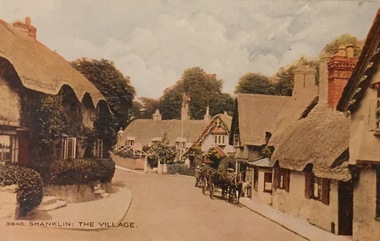
Postcard, Shanklin: The Village, c.1928
Collection of thirty-nine postcards donated by Jillian Rigby which had been owned by her grandparents, George and Edith Weir, who from c.1917 lived at 84 Princess Street, Kew. The mostly 'mint' postcards were purchased in Victoria and while travelling overseas. The sole dated postcard is dated from 1929. The postcards are numbered sequentially from 2017.0058.01-39. The remainder of the collection donated by Jill Rigby which was once owned by the Weirs of Broken Hill and Kew consist of costumes, costume accessories, photographs, and documents.The postcards in the Weir collection, especially those purchased on a trip or trips to the mother country, i.e. United Kingdom, represent a representative sample of sites that were considered significant to those Australians undertaking a reverse grand tour by member of the erstwhile colonies. Those postcards which are early views of Melbourne must have been produced commercially for some decades from the early part of the 20th century.Shanklin is a popular seaside resort and civil parish on the Isle of Wight, England , located on Sandown Bay. The postcard was probably purchased by George and Edith Weir on a trip to England and Scotland, circa 1928."31640 / Shanklin: The Village"postcards, george and edith weir, shanklin - isle of wight, postcards -- uk, weir collection -
 Kew Historical Society Inc
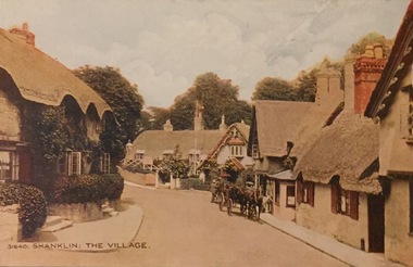
Postcard, Shanklin: The Village, c.1928
Collection of thirty-nine postcards donated by Jillian Rigby which had been owned by her grandparents, George and Edith Weir, who from c.1917 lived at 84 Princess Street, Kew. The mostly 'mint' postcards were purchased in Victoria and while travelling overseas. The sole dated postcard is dated from 1929. The postcards are numbered sequentially from 2017.0058.01-39. The remainder of the collection donated by Jill Rigby which was once owned by the Weirs of Broken Hill and Kew consist of costumes, costume accessories, photographs, and documents.The postcards in the Weir collection, especially those purchased on a trip or trips to the mother country, i.e. United Kingdom, represent a representative sample of sites that were considered significant to those Australians undertaking a reverse grand tour by member of the erstwhile colonies. Those postcards which are early views of Melbourne must have been produced commercially for some decades from the early part of the 20th century.Shanklin is a popular seaside resort and civil parish on the Isle of Wight, England , located on Sandown Bay. The postcard was probably purchased by George and Edith Weir on a trip to England and Scotland, circa 1928."31640 / Shanklin: The Village"postcards, george and edith weir, shanklin - isle of wight, postcards -- uk, weir collection -
 Kew Historical Society Inc
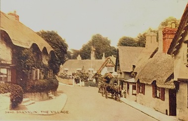
Postcard, Shanklin: The Village, c.1928
Collection of thirty-nine postcards donated by Jillian Rigby which had been owned by her grandparents, George and Edith Weir, who from c.1917 lived at 84 Princess Street, Kew. The mostly 'mint' postcards were purchased in Victoria and while travelling overseas. The sole dated postcard is dated from 1929. The postcards are numbered sequentially from 2017.0058.01-39. The remainder of the collection donated by Jill Rigby which was once owned by the Weirs of Broken Hill and Kew consist of costumes, costume accessories, photographs, and documents.The postcards in the Weir collection, especially those purchased on a trip or trips to the mother country, i.e. United Kingdom, represent a representative sample of sites that were considered significant to those Australians undertaking a reverse grand tour by member of the erstwhile colonies. Those postcards which are early views of Melbourne must have been produced commercially for some decades from the early part of the 20th century.Shanklin is a popular seaside resort and civil parish on the Isle of Wight, England , located on Sandown Bay. The postcard was probably purchased by George and Edith Weir on a trip to England and Scotland, circa 1928."Shanklin: The Village"postcards, george and edith weir, shanklin - isle of wight, postcards -- isle of wight, weir collection -
 St Patrick's Old Collegians Association (SPOCA)
Photograph - SPOCA, Tour of Ireland
-
 Waverley RSL Sub Branch
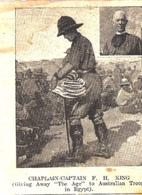
News paper Cutting Chaplain-Captain F. H. King, ? 1917
Captain Frank Herbert King was born in the Parish of St. Saviors in the borough of Brougham London March 5th 1875. He was educated in theology at St. Augustine's College Durban University. He went on to serve for 2 1/2 years in South Africa during the Boer Wars and then re-enlisted in the A.I.F.16th November 1916 when he listed his address as "The Vicarage Sunshine Victoria" and listed his wife as "Kathleen King" “Revd McCoy announced his intention of moving to the parish of Deniliquin in October 1915. He was replaced by F.H. King. Though the parish could not house him, he came in November. King was a typical “new broom”. In January 1916, at his instigation, the parish agreed to change its hymn book to Ancient and Modern. This decision could be viewed as a “churchmanship” matter, one of many that happened in these years. He pushed through the building of the vicarage, from tender in January to blessed and occupied by June. At the Annual General Meeting, King described 1915 as a trying time in the church and looked forward to a happier and more prosperous time during 1916. At a special vestry meeting, 3 November 1916, King announced that he had accepted an appointment by the Archbishop for service at the front, and that he had been instructed to prepare to go abroad. It was decided in his absence the parish use lay-readers, with periodic visits by clergy for Holy Communion. On 12 November, King thanked the parish for their loyalty and their devotion to him and the church. In return the parish presented him with a wrist watch. The parish was not formally vacant; just without a vicar. In September 1917, the Archbishop wrote advising that King had resigned. He appointed the Rev. W. Green to the parish, but Green declined.”(1) He was sent to Egypt where he administered to the Australian Stationary Hospital Australian 3rd and 5th light horse brigades. His Army record states he was Invalided and Completion of Duty 12 July 1918. He was later awarded th Order of the British Empire (OBE) 1 “The Junction” a history of St Mark’s Sunshine The picture of Chaplain-Captain F.H. King was carried in the Bible of Sig. H. C. Roussac ( a Gallipoli veteran) during his service with the A.I.F. in France. It can only be assumed that F.H.King had a profound effect on Sig. Roussac.Cutting of a lithographic picture showing Chaplain-Captain F. H. King giving away "The Age" (News paper) to Australian troops in Egypt 1917 Chaplain-Captain F. H. King giving away "The Age" to Australian troops in Egypta.i.f. egypt, chaplain, f.h.king, light horse egypt, roussac, o.b.e., boer war -
 Glen Eira Historical Society
Newsletter - St Peters Church of England, Murrumbeena
This file contains four items. THE PARISH MESSENGER St Agnes Glenhuntly and St Peters Murrumbeena – six newsletters dated from August 1912 to June 1914. St Peters Church Papers, Murrumbeena and Carnegie - two newsletters dated August 1915. St Peters Church Parish Paper, Murrumbeena and Carnegie – twenty newsletters dated from September 1917 to June 1925. St Peters Parish Paper, Murrumbeena, Carnegie and Hughesdale, nine newsletters dated from April 1926 to July 1934. All newsletters include information on Church activities, names of vicars and church officeholders.the parish messenger, st agnes glenhuntly, st peters murrumbeena, murrumbeena, phillips rev w. a., organs, glen huntly, rothschild st, addiscombe, house names, carnegie, neerim road, inghaim rev. a.e., churches, world war 1914-1918, emily street, green rev. walter, gleaners’ union, sowers (missionary band), carnegie methodist church, st peters church of england, green rev w.g.a., st peters vicarage, tennis clubs, baptisms, weddings, womens missionary unions, watts-ditchfield rev. j.e., mothers union, sunday school, ladies guild, baglin rev. j.t., hospitals’ league of mercy, nursing classes, thomas dr., faulkner e.h., advertisements, depression 1929-1939, business, fete, vestry, confirmation, bands, festivals, picnics, poynder rev. r., thos. grogan, drapery, awards, associations, church services, ingham rev. a.e., schools, cragg miss elvie, principals, choirs, st peters troop of boy scouts, hoggart miss, st peters school, st peters girls school, booth miss d., andrew miss eileen, meredith rev. charles w., church day school, walker miss, financial documents -
 National Wool Museum
Book, An appraisal of a floor-price scheme for wool
"An appraisal of a floor-price scheme for wool" -Dr J H Duley and Dr R M Parish.wool sales wool marketing wool sales - floor price scheme, wool sales, wool marketing, wool sales - floor price scheme -
 Whitehorse Historical Society Inc.
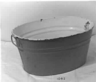
Functional object - Baby's Bath, c1880s
Used by Donor's mother's family. Grandfather Webber Parish Minister. Used by donor for her own familyTin baby bath painted yellow inside and green outside. Two bear decals insidedomestic items, ablutions -
 Ballarat Heritage Services
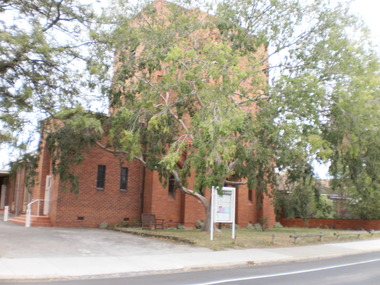
Photograph, Former Barkly Street Uniting Church, Ballarat, 2015
The church shut its doors on May 31, a date which marks the 162nd anniversary of the establishment of the parish.Church buildings associated with the former Barkly Street Uniting Church, Ballarat East. former barkly street uniting church, barkly street methodist church, ballarat east -
Lakes Entrance Historical Society
Clothing - Woman's Bathing Suit, 1930
Suit belonged to Mrs Lethbridge wife of Anglican Bush brother and Parish Priest Rev W Lethbridge.Maroon coloured woolen womans bathing costume. Narrow shoulder straps, bodice high at front, scooped back. Skirt decorated with black buttons over shorts with gusset between legs. -
 Warrnambool and District Historical Society Inc.
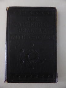
Book, The Cathedral Psalte, Early 20th century
This book has had two owners – St. Paul’s Anglican Church Allansford and Cecil Snook of Toorak but it is not known who had the book first. Nothing is known of Cecil Snook and the name does not appear to be of local interest. St. Paul’s Anglican Church in Allansford was established in 1882. It became part of the Panmure Parish in 1936 and in 1951 it was transferred to the Warrnambool Parish. This book is of interest as an example of a music book used at St. Paul’s Anglican Church in Allansford early in the 20th century. This is a hard cover book containing musical notations and text. The cover is black with embossed lettering and ornamental patterns on the front. The cover has come apart from the binding and has been re-attached with brown tape. The inscriptions are handwritten in black ink and pencil. There is some scribble on the back page. The cover is torn at the edges and the first and last pages are a little tattered. ‘St. Paul’s Allansford’ ‘All Saints Grammar School, East St. Kilda, Cecil Snook. 2 Baxter Street, Toorak, 11-6-1916’ history of warrnambool, st. paul’s anglican church allansford -
 Melbourne Tram Museum
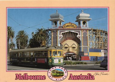
Postcard, Steve Parish Paddington Qld, SW6 940 outside Luna Park, late 1980's or early 1990's
Colour postcard cream border, divided back - Steve Parish postcard of SW6 940 outside Luna Park. Tram 940 in The Met colour scheme, possibly late 1980's or early 1990's with the destination of City, Route 16 with a Bank of Melbourne advert on the front. Back has space for name and address, stamp and a message and details of the postcard. Produced by Steve Parish Postcards. Card No. PC3021 Has "Melbourne Australia" along the bottom edge.trams, tramways, luna park, sw6 class, route 16, st kilda, tram 940 -
 Heathcote McIvor Historical Society
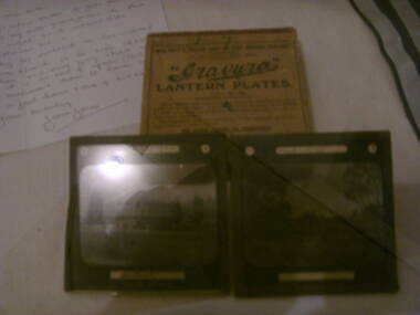
Glass Slides, Photographic, 1893
Belonged to Percy Webber who took the slides while he was parish priest of the church of england in Heathcote in 1893.these Glass slides are only known original pictures still in original box 9 in total taken in 1893 of the various views around heathcote.set of 9 Glass Plate Slides in original box. photographs of Heathcote McIvoron lid of box Gravura Lantern plates glass plate slides gravura, lantern -
Port Melbourne Historical & Preservation Society
Document - Invitation, Consecretion of Holy Trinity Anglican Church, Port Melbourne, Nov 2017
The new church has been consecrated within the original Parish Hall, after the church itself was sold for redevelopmentInvitation to attend the consecration of Holy Trinity Anglican Church of Port Melbourne by the Archbishop of Melbourne, Dr Philip Frier, Sunday 12 Nov 2017celebrations fetes and exhibitions, religion - anglican (holy trinity), rev noel whale, rev dr philip frier -
 Uniting Church Archives - Synod of Victoria
Photograph, Father Shimuye Mebratu with his silver Orthodox cross, 20/02/1985
Father Shimuye Mebratu is one of a growning number of Orthodox priests driven from their parish by drought in Wello Province.B & W waist length photograph of Father Shimuye Mebratu carrying a silver Orthodox cross."Father Shimuye Mebratu with his silver Orthodox cross Reproduction permission is granted for editorial purposes only. World Vision photo credit must be given at all times when reproducing this photo World Vision Media Department Phone (03) 699 8765 C&N 20/2/1985 page 7"mebratu, shimuye, father, orthodox cross -
 Whitehorse Historical Society Inc.
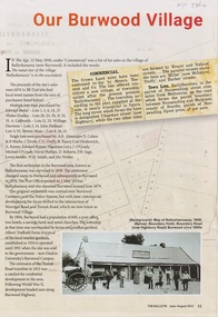
Article - The Bulletin newsletter, The Bulletin Jun - Aug 2022, Our Burwood Village, June 2022
An article about the first settlement surveyed in 1858 in the Burwood area known as Ballyshanassy. It later became Norwood and finally Burwood in 1879.An article about the first settlement surveyed in 1858 in the Burwood area known as Ballyshanassy. It later became Norwood and finally Burwood in 1879.An article about the first settlement surveyed in 1858 in the Burwood area known as Ballyshanassy. It later became Norwood and finally Burwood in 1879.ballyshanassy, albers ernest, boundary road burwood east, dempsey -
 Greensborough Historical Society
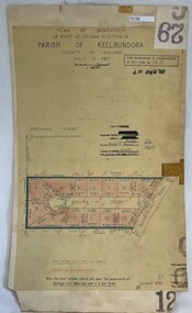
Poster - Planning Document, City of Heidelberg, Subdivision Plan # G 29 Part 2, Crown portion 16, Greensborough, 1951
Plan of Subdivisions in City of Heidelberg: Parish of Keelbundoora: Crown portion 16 - Daours Court and Devonshire Road, 1951.An example of hard copy subdivision plans from the Greensborough area. Mainly from the Shire of Diamond Valley era (1964-1994).Plan (single sided) mounted on heavy card. Stamped and handwritten Council permissions, dates and other details.subdivision plans, city of heidelberg -
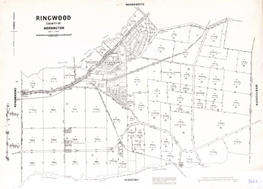 Ringwood and District Historical Society
Map - Parish of Ringwood, County of Mornington, Victoria, Original Land Owners
Laminated Parish map of Ringwood detailing original Land Owners' names, property locations and acreages. Details reproduced in 1957 by the Department of Lands and Survey, Melbourne, from original surveys of varying dates. -
![Plan - Parish Plan [detail], Ballarat School of Mines and Surrounds](/media/collectors/4f729f6797f83e0308601707/items/5ba19e4c21ea711bb04808c5/item-media/5ba19e5e21ea711bb0481cd2/item-fit-380x285.jpg) Federation University Historical Collection
Federation University Historical CollectionPlan - Parish Plan [detail], Ballarat School of Mines and Surrounds
Copy of a section of a Ballarat Parish Plan showing the Ballarat School of Mines, Wesleyan Church Reserve, Ballarat Gaol Reserve, Ballarat Technical School, United Welsh Protestant Church. Origin is unknown.parish plan, ballarat school of mines, ballarat junior technical school, lydiard street south, grant street, albert street, united welsh protestant church, armstrong street south, hickman street, ballarat gaol -
Bendigo Historical Society Inc.
Map - CAMPBELL COLLECTION: BENDIGO AND DISTRICT MAPS, 12-2-29
Map. Axedale, Parish of Ellesmere and Axedale, Total area 4156 acres, Prepared in W.P.B. from A. and P. Plans by W.J. Galbraith 12-2-29. (number 383 in map cupboard 1)W.J.Galbraithmap, bendigo, agricultural lands -
Bendigo Historical Society Inc.
Map - CAMPBELL COLLECTION: BENDIGO AND DISTRICT MAPS, 15-2-29
Map. Nerring, Parish of Nerring, scale 20 chains to 1 inch. Prepared in W.P.B. from A. and P. Plans by W.J. Galbraith. 15-2-29. (number 379 in map cupboard 1)W.J.Galbraithmap, bendigo, agricultural lands -
Bendigo Historical Society Inc.
Map - CAMPBELL COLLECTION: BENDIGO AND DISTRICT MAPS, 15-2-29
Map. Nerring, Parish of Nerring, scale 20 chains to 1 inch. Prepared in W.J.B. from A and B plans by W.J. Galbraith 15-2-29. (number 356 in map cupboard 1)W.J.Galbraithmap, bendigo, parish plan -
Whitehorse Historical Society Inc.
Map, Dandenong Ranges Area, 1956
Sheet 1. Parts of Parishes: Nunawading, Warrandyte and Ringwood. Scale: 10 chains : 1 inch. Contour intervals marked and locations of buildings.Sheet 1. Parts of Parishes: Nunawading, Warrandyte and Ringwood. Scale: 10 chains : 1 inch. Contour intervals marked and locations of buildings. Compiled from aerial photographs and cadastral survey information.Sheet 1. Parts of Parishes: Nunawading, Warrandyte and Ringwood. Scale: 10 chains : 1 inch. Contour intervals marked and locations of buildings. maps, ringwood, mitcham, warrandyte -
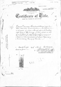 Whitehorse Historical Society Inc.
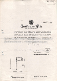
Certificate - Certificate of Title, Crown Allotment, 12/04/1904
Certificate of Title dated 12/4/1904 covering land in Shady Grove, Nunawading purchased by David Duncan Butchart Wilson. Crown Land Allotment No. 116 Parish of Nunawading County of Bourkeland titles, wilson, david duncan butchart, shady grove nunawading no. 76, higgins, mary, alcock, horace, holmes, dave, thumberstone, henry, helen -
Whitehorse Historical Society Inc.
Book, Gathered into one, 1988
Book written by Jean Cornell giving glimpses of Mitcham and its Methodist, Presbyterian and Uniting Churches between 1888 - 1988, published by the Centenary Committee of Mountview Church, Mitcham Parish of the Uniting Church.methodist church mitcham, mitcham presbyterian church, mountview uniting church, mitcham -
 Port Melbourne Historical & Preservation Society
Photograph - St Joseph's Catholic Primary School, Premiers, Peanut Farm Reserve, St Kilda, 1960s
B&W photo St Josephs Catholic Primary Premiers 1967, taken at the Peanut Farm Reserve in St Kilda. The parish priest is at centre back, coach Phyl NICHOLLS at back right.phyl nicholls, education - primary schools, sport - australian rules football, st josephs catholic primary school, religion - roman catholic church (st josephs) -
Lakes Entrance Historical Society
Book, Rev Albert E Clark, Church of our Fathers, 1947
A history of the Church of England in Gippsland from 1847 to 1947, the parishes and priests. This book also gives an insight into the early settlers of Gippsland, the growth of communities, and the hardships of families living in isolation. Illustrated wireligion -
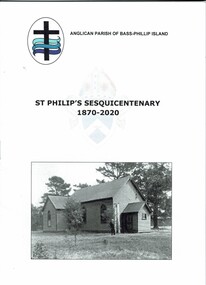 Phillip Island and District Historical Society Inc.
Booklet, St Philip's Sesquicentenary1870-2020
The first Anglican Church in Cowes was opened in January 1870. It was used also as a school and for social events. HistoricalAn A5 typed booklet with black and white photos containing the order of service and a brief history of the church. Also a copy of the Parish Paper 2 February 2020, which includes a tribute to Una Lyons.st philip's church of england, sesquicentenary, cowes anglican church phillip island, una lyons -
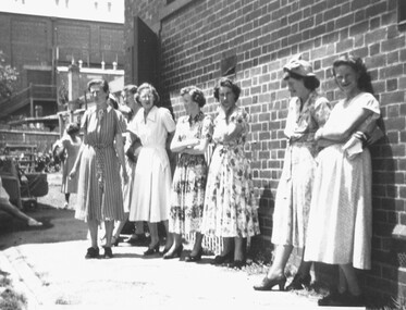 Ringwood and District Historical Society
Photograph, 1950 - Parish Hall Xmas Party, Church of England, Ringwood Street, Ringwood. Left to right: Mrs. Radok, Mrs. McWilliam, Mrs. Win Leslie, Mrs. Jess Anderson, (unknown), and Mrs. Enid Durston
Typed below photograph, "1950 - Parish Hall Xmas Party. Mrs. Radok, Mrs. McWilliam, Mrs. Win Leslie, Mrs. Jess Anderson, ??, Mrs. Enid Durston". -
 Eltham District Historical Society Inc
Document - Property Binder, 727 Main Road, Eltham
Copy Certificate of Title, plan of subdivision Part of Crown Portion 12 Section 4 Parish of Nillumbik County of Evelyn.main road, eltham, property, houses, shops, businesses