Showing 825 items matching "plenty river"
-
 Marysville & District Historical Society
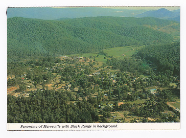
Postcard (item) - Colour postcard, K. & H. Ellis, Panorama of Marysville with Black Range in background, Pre 2009
A colour photograph of a view of Marysville in Victoria.A colour photograph of a view of Marysville in Victoria. The photograph has been taken from one of the many lookouts that surround Marysville.Panorama of Marysville with Black Range in background. Colorscans MARYSVILLE - VICTORIA Panorama of Marysville with Black/ Range in background. c PUBLISHED & PRINTED BY COLORSCAPES PUBLISHING PTY LTD 118-120 BRIGHTON STREET RICHMOND 3121 Supa-vu/ cards Photographed and Distributed by:/ K. & H. ELLIS - 35 Old Warburton Road/ Warburton 3799 20-1-81/ Dear Mum/ Just a line/ to let you know we/ have settled in here./ Its a nice park not to/ big, with a river in/ behind the van. (its/ more like a swift/ running creek, the/ kids are really enjoying/ it. There are plenty of/ walks to go on, up here/ tracks everywhere./ Hows the cooler going/ keeping you cool?/ We are able to say here until/ Sunday./ See you Mum/ Love Lois, Tom,/ & Kids. Mrs A. McTaggart/ 2 Frederick Street/ Kyabram Vic/ 3620. On reverse of postcard are 5 black marks; one in each corner and one in the centre from where the postcard has been removed from an album.marysville, victoria, postcard, souvenir, k & h ellis, colorscans publishing -
 Eltham District Historical Society Inc
Negative - Photograph, Carl Walter 1831-1907, Coffer dam in the Yarra River at Anderson's Creek, 1864
1864 photograph of the Coffer Dam in the River Yarra situated (approximately) opposite Whipstick Gully. Remains of bridge built in 1860(?) wrecked by 1863 flood in background. Reproduced page 29 of ‘Pioneers & Painters’ Gold was first discovered in this area at Andersons Creek (Warrandyte) in June 1851 by Louis Michel. Discoveries north of the Yarra did not occur until about 1854. Although it took some months for a true rush to develop it was not long before alluvial workings were being carried on in most of the Shire of Eltham. The last area in which gold was discovered was Kinglake. As the gold became harder to find, deep mining took over from alluvial diggings in the gullies. Perhaps the most extensive of the deep workings was the Diamond Creek Mine just outside the boundary of the Shire. This form of mining was continued into the 1930s. There are believed to be some mines in the area still capable of producing gold but present prices make working these uneconomical. Some gold is still found by weekend prospectors. Photo: Carl Walter 1831-1907 – inscribed on tent “C. Walter Photo” The State Library of Victoria holds over 150 photos by Carl Walter, most of which are portraits of Aboriginal natives including William Barak.This photo forms part of a collection of photographs gathered by the Shire of Eltham for their centenary project book,"Pioneers and Painters: 100 years of the Shire of Eltham" by Alan Marshall (1971). The collection of over 500 images is held in partnership between Eltham District Historical Society and Yarra Plenty Regional Library (Eltham Library) and is now formally known as 'The Shire of Eltham Pioneers Photograph Collection.' It is significant in being the first community sourced collection representing the places and people of the Shire's first one hundred years.Digital image 4 x 5 inch B&W Neg (2) Print 20 x 25 cmshire of eltham pioneers photograph collection, anderson's creek, coffer dam, floods, gold mining, other areas, pioneers and painters, warrandyte, warrandyte bridge, yarra river -
 Eltham District Historical Society Inc
Photograph, Heidelberg - River Yarra in flood at Heidelberg, 1934, 1934
This photo forms part of a collection of photographs gathered by the Shire of Eltham for their centenary project book,"Pioneers and Painters: 100 years of the Shire of Eltham" by Alan Marshall (1971). The collection of over 500 images is held in partnership between Eltham District Historical Society and Yarra Plenty Regional Library (Eltham Library) and is now formally known as the 'The Shire of Eltham Pioneers Photograph Collection.' It is significant in being the first community sourced collection representing the places and people of the Shire's first one hundred years.Digital imagesepp, shire of eltham pioneers photograph collection, other areas, yarra river, floods -
 Eltham District Historical Society Inc
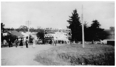
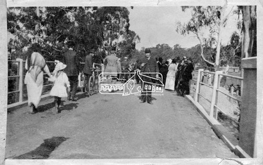
Photograph, Hurstbridge - Cr. Price crossing New Bridge (Opening Day), 1917, 1917
Eltham Shire Councillor Albert Price joined over 500 spectators for the official opening of the new re-inforced concrete bridge across the Diamond Creek at Hurstbridge. Eltham Shire shared the cost of the construction of the bridge with Heidelberg and Whittlesea Shires.This photo forms part of a collection of photographs gathered by the Shire of Eltham for their centenary project book, "Pioneers and Painters: 100 years of the Shire of Eltham" by Alan Marshall (1971). The collection of over 500 images is held in partnership between Eltham District Historical Society and Yarra Plenty Regional Library (Eltham Library) and is now formally known as 'The Shire of Eltham Pioneers Photograph Collection.' It is significant in being the first community sourced collection representing the places and people of the Shire's first one hundred years.Digital imagesepp, shire of eltham pioneers photograph collection, diamond creek, hurstbridge, wattle glen, bridge, councilor price, opening day, diamond creek (river) -
 Eltham District Historical Society Inc
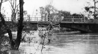
Negative - Photograph, Diamond Creek floodwater at Monash Bridge, Hurstbridge, Dec. 1934
The historic 1934 flood of the Diamond Creek and Yarra River following the storms of 29-30 November set the levels for future planning with respect to flood water rise.This photo forms part of a collection of photographs gathered by the Shire of Eltham for their centenary project book,"Pioneers and Painters: 100 years of the Shire of Eltham" by Alan Marshall (1971). The collection of over 500 images is held in partnership between Eltham District Historical Society and Yarra Plenty Regional Library (Eltham Library) and is now formally known as the 'The Shire of Eltham Pioneers Photograph Collection.' It is significant in being the first community sourced collection representing the places and people of the Shire's first one hundred years.Digital image 4 x 5 inch B&W Negshire of eltham pioneers photograph collection, hurstbridge, 1934 flood, floods, monash bridge, diamond creek (creek) -
 Eltham District Historical Society Inc
Negative - Photograph, J. P. Lind, Hurst's Bridge, 1885
Looking northwest onto the first bridge at Hurstbridge, 1885. Timber bridge amid rural setting. Two horses graze in an open paddock in the foreground. A house is situated on a rise behind the bridge on a tree lined hill. The area of Hurstbridge was originally known as Hurst’s-bridge after the timber bridge built over the Diamond Creek near Hurst’s station in late 1881/early 1882 on the Hurstbridge-Arthurs Creek Road, Hurstbridge. It was built by John McDonald, of Arthur's Creek and was demolished and replaced in 1917 by a reinforced concrete arch bridge designed by John Monash. Cross Reference Photo No.(s): 1012/1013This photo forms part of a collection of photographs gathered by the Shire of Eltham for their centenary project book, "Pioneers and Painters: 100 years of the Shire of Eltham" by Alan Marshall (1971). The collection of over 500 images is held in partnership between Eltham District Historical Society and Yarra Plenty Regional Library (Eltham Library) and is now formally known as 'The Shire of Eltham Pioneers Photograph Collection.' It is significant in being the first community sourced collection representing the places and people of the Shire's first one hundred years.Digital image 4 x 5 inch B&W Negshire of eltham pioneers photograph collection, hurstbridge, bridge, diamond creek (river), diamond creek (creek), hurst's bridge -
 Eltham District Historical Society Inc
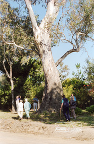
Photograph, Large River Red Gum, Stawell Road, Lower Plenty; Autumn Excursion to Lower Plenty area, 18 April 1998, 18/04/1998
... melbourne activities lower plenty stawell road trees river red gum ...Roll of 35mm colour negative film, 2 stripsKodak Gold 200-6activities, lower plenty, stawell road, trees, river red gum -
 Eltham District Historical Society Inc
Photograph, Amberley, Lower Plenty; Autumn Excursion to Lower Plenty area, 18 April 1998, 18/04/1998
Looking westerly across the Yarra from Westerfolds Park you can see a large and imposing building at the top of the escarpment above the river. This is the Christian Brothers Training Centre at Lower Plenty and known as Amberley. This significant building dates from 1930 when it was the rather grand residence of Oswald Darch. It was purchased by the Catholic Church in 1955 and has since been significantly extended.Roll of 35mm colour negative film, 2 stripsKodak Gold 200-6activities, lower plenty, amberley -
 Eltham District Historical Society Inc
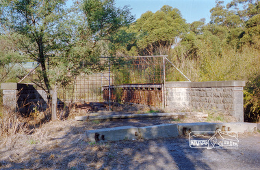
Negative - Photograph, Old Lower Plenty Bridge, 18 Apr 1998
... melbourne EDHS Autumn excursion to Lower Plenty area The blocked-off ...EDHS Autumn excursion to Lower Plenty area The blocked-off iron bridge at Lower Plenty - now re-opened and used as a footway/bike path section joining the Yarra River path.Roll of 35mm colour negative film, 2 strips and associated colour printKodak Gold 200-6activities, lower plenty bridge, autumn excursion, eltham district historical society, lower plenty -
 Wodonga & District Historical Society Inc
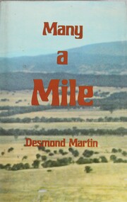
Book - Many a Mile, Desmond Martin, 1976
An historical novel set in 1892 along the Murray River country, Australia. Stories of the pioneering days full of colourful, authentic characters and plenty of action.non-fictionAn historical novel set in 1892 along the Murray River country, Australia. Stories of the pioneering days full of colourful, authentic characters and plenty of action.australian pioneers, murray river country -
 Eltham District Historical Society Inc
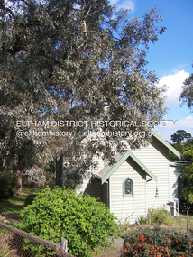
Photograph - Digital Photograph, Marguerite Marshall, Former Methodist Church, Plenty, 5 August 2008
In 1924, the Methodist Church opened at the corner of River Ave and Yan Yean Road, Plenty. It was a simple weatherboard gabled building. The church developed a strong community life with celebrations as well as worships, Sundays Schools and social events. It closed in 1979. Covered under Heritage Overlay, Nillumbik Planning Scheme. Published: Nillumbik Now and Then / Marguerite Marshall 2008; photographs Alan King with Marguerite Marshall.; p113 In 1924, the Methodist Church, (which closed in 1976), opened at the corner of River Avenue and Yan Yean Road. Church members including George Starling and Ernest Osmond, built the simple weatherboard gabled building.3 The church developed a strong community life, with celebrations as well as worship through Sunday School anniversaries, picnics, harvest festivals and youth groups. Many volunteers worked hard for the church - teaching Sunday School and ferrying young people to events, sometimes in the backs of trucks and furniture vans. Children from the Sutherland Homes were brought to church by their Matron – a ‘grim martinet’! Members included the Ashton, Reid, Harris, McLachlan, Hopkin, Rose and Stuchbery families. The first wedding was for Vida McLachlan and Ray Stuchbery.4This collection of almost 130 photos about places and people within the Shire of Nillumbik, an urban and rural municipality in Melbourne's north, contributes to an understanding of the history of the Shire. Published in 2008 immediately prior to the Black Saturday bushfires of February 7, 2009, it documents sites that were impacted, and in some cases destroyed by the fires. It includes photographs taken especially for the publication, creating a unique time capsule representing the Shire in the early 21st century. It remains the most recent comprehenesive publication devoted to the Shire's history connecting local residents to the past. nillumbik now and then (marshall-king) collection, methodist church, plenty -
 Eltham District Historical Society Inc
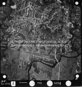
Photograph - Aerial Photograph, Landata, Montmorency / Lower Plenty, Jan. 1962
Centred on 147 Old Eltham Road, Lower Plenty bounded by Hurstbridge Railway Line to north, Yarra River to south, Main Road, Eltham to east and Heidelberg Golf Club to west. Historic Aerial Imagery Source: Landata.vic.gov.au Aerial Photo Details: Project No : 539 Project : MELBOURNE-GEELONG PROJECT Run : 6 Frame : 81 Date : 01/1962 Film Type : B/W Camera : RC5 Flying Height : 6000 Scale : 15840 Film Number : 1524 GDA2020 : 37°43'52"S, 145°07'26"E MGA2020 : 334685, 5822354 (55) Melways : 21 D9 (ed. 42)aerial photo, lower plenty, main road, montmorency, phoebe mason collection, eltham, eltham lower park, heidelberg golf club, hurstbridge railway line, main road eltham, yarra river -
 Eltham District Historical Society Inc
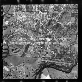
Photograph - Aerial Photograph, Landata, Montmorency / Lower Plenty, Feb. 1956
Centred on 20 Panorama Avenue, Lower Plenty bounded by Rattray Road to north, Yarra River to south, Bolton Street to east and Heidelberg Golf Club to west. Historic Aerial Imagery Source: Landata.vic.gov.au Aerial Photo Details: Project No : 250 Project : MELBOURNE OUTER SUBURBS PROJECT Run : 16A Frame : 53 Date : 02/1956 Film Type : B/W Camera : EAG9 Flying Height : 10000 Scale : 12000 Film Number : 1187 GDA2020 : 37°43'47"S, 145°07'25"E MGA2020 : 334645, 5822519 (55) Melways : 21 D9 (ed. 42)aerial photo, lower plenty, main road, montmorency, phoebe mason collection, bolton steet, heidelberg golf club, rattray road -
 Eltham District Historical Society Inc
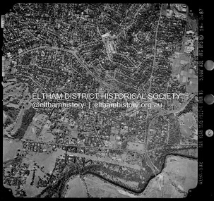
Photograph - Aerial Photograph, Landata, Montmorency / Lower Plenty, Mar. 1987
Centred on 354-356 Main Road, Lower Plenty bounded by Rattray Road, Montmorency to north, Yarra River to south, Falkiner Street, Eltham to east and Lower Plenty shops to west. Historic Aerial Imagery Source: Landata.vic.gov.au Aerial Photo Details: Project No :1716 Project : WESTERN PORT FORESHORES Run : 16 Frame : 132 Date : 03/1987 Film Type : B/W Camera : RC10 Flying Height : 5600 Scale : 10000 Film Number : 4102 GDA2020 : 37°43'51"S, 145°07'38"E MGA2020 : 334968, 5822406 (55) Melways : 21 E9 (ed. 42)aerial photo, lower plenty, main road, montmorency, phoebe mason collection, eltham, eltham lower park, falkiner street, lower plenty shops, main road eltham, rattray road, yarra river -
 Eltham District Historical Society Inc
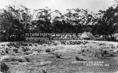
Photograph, Eltham - Convention Camp, 1911
Tents set up along the Diamond Creek on a property that would become "Willandra," a poultry farm and then in 1956, an aged care facility and residence known as Judge Book Village. It is located west of the railway line, north of the railway station in Eltham on Diamond Street. it is believed that the convention camp was for young people for the purpose of Christian fellowship, bible study and worship. Other activities included local hikes. A report in the Evelyn Observer on Friday, January 6, 1911, p2 noted: "ELTHAM. The holiday season brought out lots of visitors to our beauty spot. The visitors booked to Eltham on Boxing-Day numbered about 1900, and New Year's Day (Monday) some 1500. The threatening aspect of the weather on the morning of the 2nd and no doubt deterred many from venturing out. Fine weather has prevailed throughout, and the chief sufferers are those who catered for hot, thirsty crowds and did not find them so bent on ices and fluid refreshments as is usual at this time of the year. Campers have been strongly in evidence. One especially large camp of Christian enthusiasts being located near the station with dining booth, gospel tent, cooking range, etc., all complete, numbering some twenty tents. These good folk evidently intend to make the best of both worlds, but some of their negro camp meeting methods appear to have shocked the sensibilities of sober-going folk. With the exception of a slight ruction on the railway platform on Monday night, which will probably be aired in the local court, the holiday makers as a whole were very orderly." This photo forms part of a collection of photographs gathered by the Shire of Eltham for their centenary project book, "Pioneers and Painters: 100 years of the Shire of Eltham" by Alan Marshall (1971). The collection of over 500 images is held in partnership between Eltham District Historical Society and Yarra Plenty Regional Library (Eltham Library) and is now formally known as 'The Shire of Eltham Pioneers Photograph Collection.' It is significant in being the first community sourced collection representing the places and people of the Shire's first one hundred years.Digital imagesepp, shire of eltham pioneers photograph collection, eltham, convention camp, judge book village, tents, diamond creek (river), camping, christian camp, boxing day