Showing 3069 items matching "scales"
-
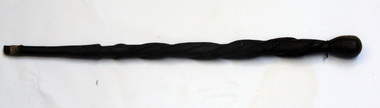 Orbost & District Historical Society
wooden club
A carved black wooden club with a thick scaled snake coiled around it. At the clubbing end is a solid round ball. It is handmade and believed to have originated in the New Hebrides.weapon wood-carving new hebrides hunting -
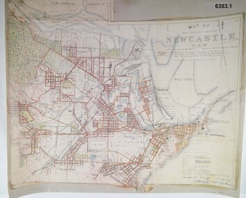 Bendigo Military Museum
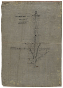
Map - Map of Newcastle NSW 4 Inch - 1 Mile 1910, Australian Intelligence Corps, Nov 1910
In 1909 the Australian Army Headquarters realized that mapping in Australia was either non existent or inadequate for Military use. It was requested that Australia borrow Survey personnel from the UK Royal Engineers (RE) for a two-year detachment. On 11 April 1910 four RE NCOs arrived in Melbourne comprising CPL J Lynch, and LCPLs AH Barrett, EF Davies and R Wilcox. LCPL Barrett had 12yrs experience with RE. They were aiming at producing eight map sheets per year covering about 7,000 square miles (18,000 square Km) This map sheet of the Newcastle area was produced using plane table methods and was surveyed and hand drawn by LCPL A Barrett Oct - Nov 2010. It was unique because it was now produced on an accurate gridded base and included contouring. Lynch and Davies transferred to the Royal Australian Engineers (RAE) whilst Barrett and Wilcox returned to the UK in June 1913. Barrett returned to Australia in 1915 and also enlisted in the RAE and served until 1919.A gridded Map of Newcastle NSW area scale four inches to one mile with 25 feet interval contouring. Coloured hand drawn map produced in 1910. Signed by " A Barrett LCPL Royal Engineers"royal australian survey corps, rasvy, fortuna, army svy regt, army survey regiment -
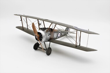 Montmorency–Eltham RSL Sub Branch
Model - Sopwith Camel (scale model)
Painted to resemble the aircraft flown by Captain H. Watson of 4 Squadron AFC in mid 1918. Herbert Gilles Watson was the highest scoring New Zealand ace in the AFC. Credited with 14 victories, he was the fourth highest scorer in the squadron.1/32 scale model of a Sopwith Camel F.1 painted to resemble an aircraft of No. 4 Squadron Australian Flying Corps (AFC) on the Western Front in 1918. -
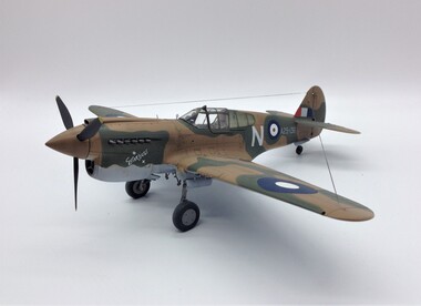 Montmorency–Eltham RSL Sub Branch
Model - P40E-1 Kittyhawk (scale model)
The original aircraft depicted was assigned to the US 5th Air Force, 49th Fighter Group, 9th fighter Squadron and flown by Lt. Reynold from May 1942 until early August 1942. The aircraft was nicknamed "Stardust". On 8th August 1942 this P40 was assigned to the Royal Australian Air Force as Kittyhawk A29-136 and assigned the code letter "N", retaining the "Stardust" nickname. This aircraft was often flown by Flying Officer Bruce Watson of 75 Squadron RAAF.1/48 plastic scale model of a P40E-1 Kittyhawk painted to represent 75 Squadron, Royal Australian Air Force in New Guinea in mid 1942.kittyhawk -
 Glenelg Shire Council Cultural Collection
Photograph - Photograph - aerial view of Portland, c. 1954
Black and white aerial photograph of coastline around Portland. Black border, scale all sides, 5 rows of 3 't' at regular intervals. All oceanFront: '784 - 156- handwritten, white, border 'RUN 7 A PORTLAND', printed, white, borderaerial photography, central portland, portland harbour, south west coastline -
Glenelg Shire Council Cultural Collection
Photograph - Photograph - Aerial photograph of coastline around Portland, Victoria, c. 1954
Black and white aerial photograph of coastline around Portland. Black border, scale all sides, 5 rows of 3 't' at regular intervals. Mostly landFront: '607 - 52 ' - handwritten, white, border 'RUN 7 ' 'PORTLAND', printed, white, border -
Glenelg Shire Council Cultural Collection
Photograph - Photograph - aerial view of Portland, c. 1954
Black and white aerial photograph of coastline around Portland. Black border, scale all sides, 5 rows of 3 't' at regular intervals. Mostly landFront: '607 - 53 ' - handwritten, white, border 'RUN 7 ' 'PORTLAND', printed, white, borderaerial photography, central portland, portland harbour, south west coastline -
 Federation University Historical Collection
Plan, Sovereign Quartz Mining Co
Transverse section of the Sovereign Quartz Mining Company's works hand drawn onto paper on waxed linen. The scale is 80- feet to 1 inch or 1:960mining, sovereign quartz mining co., cgt -
Bendigo Historical Society Inc.
Map - CAMPBELL COLLECTION: BENDIGO AND DISTRICT MAPS
Map. Mandurang, Parish of Mandurang. Scale 20 chains to 1 inch. Total area 5993 acres. Northern Railway. (number 395 in map cupboard 1)map, bendigo, allotments -
Bendigo Historical Society Inc.
Map - CAMPBELL COLLECTION: BENDIGO AND DISTRICT MAPS
Map. Lyell, Parishes of Sedgwick, Eppalock and Lyell. Scale 20 chains to 1 inch. Total area 3307 acres. (number 387 in map cupboard 1)map, bendigo, country lands -
 Bendigo Historical Society Inc.
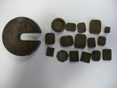
Tool - WEIGHTS
Assorted brass weights marked penny weights, various sized weights plus one platform scales weight marked 1/4, 17 weights in total.Standard Wweighing, weights & measures -
The Ed Muirhead Physics Museum
Slide Rule, cylindrical / “FullerCalculator”
“FULLER CALCULATOR” : a wooden cylindrical slide rule(92.1) with spiral logarithmic scale 500 inches long. and specially made rectangular box (92.2) and pamphlet (92.3).Engraved on metal of adding machine (92.1): “8462/45” Label on inside of box: “Stanley Trademark Everything for the Engineer Architect and Surveyor in field and drawing office. W.F.Stanley & Co. Ltd, 286 High Holborn London WC1” Stamped on pamphlet: “University of Melbourne Department of Statistics” Label on top box: “display” -
Bendigo Historical Society Inc.
Map - BENDIGO SHEET 12, Reproduced 1961
Map; Bendigo Sheet 12, Parish of Sandhurst , County of Bendigo, Parish plan, Scale 2 chains to 1 inch ( number 142 in Map Cupboard 1)map, bendigo, city streets, bendigo sheet 12, parish of sandhurst , county of bendigo -
Whitehorse Historical Society Inc.
Map, Nunawading Planning Scheme, 7/06/1994 12:00:00 AM
Local Section maps 1 - 4 with index. Geographical information system land Information Branch. Scale 1:10,000 Shows zoning under planning scheme.Local Section maps 1 - 4 with index. Geographical information system land Information Branch. Scale 1:10,000 Shows zoning under planning scheme.Local Section maps 1 - 4 with index. Geographical information system land Information Branch. Scale 1:10,000 Shows zoning under planning scheme.blackburn, blackburn north, blackburn south, forest hill, heatherdale, maps, nunawading, vermont, vermont south, town planning, burwood east, laburnum -
 Parks Victoria - Mount Buffalo Chalet
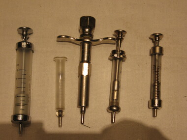
Syringes
'A range of first aid supplies, including older types of stretchers and syringes emphasise the importance given over the years to emergency equipment and to the need for remedial items such as bedpans and invalid cups.' (Pg. 110. Historica) For many years whilst under Railways Management the First Aid Room was opposite the stairs leading down to the Café, on the left hand side leading up to the Dining Room. Here skiing and recreational injuries were attended to.Listed in Draft Inventory of Significant Collection items. Appendix A.3.Staff Equipment. (Pg 167 Historica).Syringes: from .01 till ..04 they have a scale ,they are made with Glass, .01 5ml .02 1ml, .03 20ml, .04 22ml, .05 are made with metal..01 British made 200`C, Everett .02 Gima .03 JJEFF, record british make original .04 original record .05 W.G.LTD Sydney -
The Ed Muirhead Physics Museum
FH 40H Radiameter/Geiger Counter
Used for measuring the intensity of gamma-radiation and x-rays, and detecting beta rays.Grey, rectangular Geiger counter box with two black dials and viewing window with measurement scale. Four slits in top with setting dial on upper right side.Embossed sticker (top of front): 'CALIBRATED DEC. 68 / MULT. READINGS BY I.3' Labels on dials and measurement viewing window.radiameter, geiger counters, radiation measurement, scientific equipment, frieseke & hoepfner, germany -
Glenelg Shire Council Cultural Collection
Plan - Plan / line drawing of a steel tuna vessel, c. 1978
Port of PortlandFront: '12'- black texta, top right cornerport of portland -
Glenelg Shire Council Cultural Collection
Plan - Plan - Port of Portland Slipway Fishing Vessel 'Gypsy Rose', 20/09/1983
port of portland -
Glenelg Shire Council Cultural Collection
Plan - Plans - Port of Portland Steel Tuna Vessel, general arrangement, 07/12/1978
Front: '25'- black texta, top right cornerport of portland -
University of Melbourne, Burnley Campus Archives
Plan, Garden Advisory Centre Summer House. Landscape working drawing 1:50, 1985
Copy of Landscape Working Drawing for the Agriculture Research Institute by the Public Works Department, Victoria No 85-523 L1/1 dated 30.01.1985. Scale 1:50.garden advisory centre, summer house, agriculture research institute, victoria public works department, landscape drawing, burnley gardens -
 Bendigo Historical Society Inc.
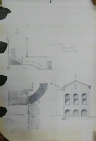
Document - MARKS COLLECTION: ALTERATIONS TO FORTUNA VILLA FOR G. LANSELL
Copy of plan: Proposed alterations to Fortuna House (not Villa) for G. Lansell Esq. Plan shows stairway, building. Scale 1/4 inch - 1 foot.buildings, house, fortuna villa -
 Bendigo Military Museum
Map - TRENCH MAP, FRANCE WW1, 1918
Areas covered on this map, “Ribemont, Morlancourt, Dernacourt, Fricourt, Mericourt, Saily Le Sec” Item re William Alexander No 502 AIF. Refer Cat No 3746.3 for his service details.Trench map, France, Edition 2 E, sheet 62D N.E, scale 1:20,000, trenches corrected to 28.5.1918, German trenches in red, British in blue.map, france, trench -
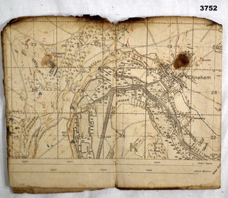
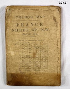 Bendigo Military Museum
Map - TRENCH MAP, FRANCE WW1, 1917
Main Australian areas on this map include “Grevillers, Bapaume and Fremicourt” Item re W.A Alexander No 502 AIF. Refer Cat No 3746.3 for his service details.Trench map, France, sheet No 57N.W. Edition6A, scale 1:20,000, trenches corrected to 7.2.1917, German trenches in red, on rear glossary of terms French to English.map, trench, france -
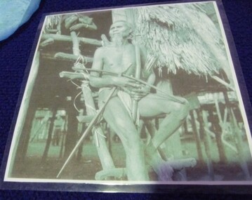 National Vietnam Veterans Museum (NVVM)
Photograph, Photo of Montagnard Soldier
Laminated photo grey scale, depicting Vietnamese village, including stilted house, with a Montagnard Vietnamese man sitting on a wooden ladder holding a Montagnard dagger c1964.photograph, vietnamese village scene -
Glenelg Shire Council Cultural Collection
Domestic object - Plastic Drink Bottle - Portland Coast Water, n.d
Portland Coast Water plastic drink bottle, opaque, blue lid, Portland Coast Water logo back and front.Front: Side: metric scale from 100-400mls - embossed Back: Base: Bottles of Australia - Logo) Made in Australia ) embossedportland coast water -
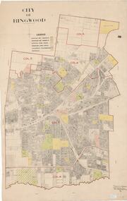 Ringwood and District Historical Society
Map, City of Ringwood - Rateable Properties Layout - c.1966. Overlay showing Reserves, Open Space, Playgrounds, and Schools
A0-size (approx) map of named streets, lot-numbered properties and locality features within City of Ringwood boundary. Colour-coded legend identifying Existing Rec Reserves, Proposed Rec Reserves, Existing Open Space, Children's Playgrounds, and Schools.Scale: 8 chains to 1 inch. Map picked up in Engineer's office at old town hall prior to demolition 1971. -
 Ringwood and District Historical Society
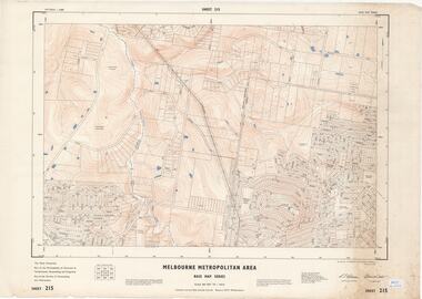
Map - Melbourne Metropolitan Area Base Map Series, Sheet 215 - Ringwood area, 1967
Map prepared by Dept of Lands and Survey and MMBW from State Aerial Survey June 1957 and Cadastral Survey information July 1967. This sheet comprises parts of Municipalities of Doncaster & Templestowe, Nunawading and Ringwood, and Parishes of Nunawading and Warrandyte.Scale: 400 feet to 1 inch. Contours at 5 feet vertical interval. By Authority: A.C. Brooks, Commonwealth Printer, Melbourne. -
 Ringwood and District Historical Society
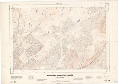
Map - Melbourne Metropolitan Area Base Map Series, Sheet 216 - Ringwood area, 1967
Map prepared by Dept of Lands and Survey and MMBW from State Aerial Survey June 1957 and Cadastral Survey information July 1967. This sheet comprises parts of Municipalities of Croydon, Doncaster & Templestowe, and Ringwood, and Parishes of Ringwood and Warrandyte.Scale: 400 feet to 1 inch. Contours at 5 feet vertical interval. By Authority: A.C. Brooks, Commonwealth Printer, Melbourne. -
 Ringwood and District Historical Society
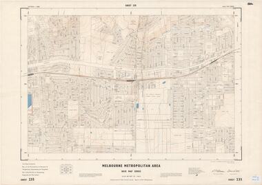
Map - Melbourne Metropolitan Area Base Map Series, Sheet 235 - Ringwood area, 1960
Map prepared by Dept of Lands and Survey and MMBW from State Aerial Survey June 1957 and Cadastral Survey information August 1960. This sheet comprises parts of Municipalities of Doncaster & Templestowe, Nunawading and Ringwood, and Parishes of Nunawading, Ringwood and Warrandyte.Scale: 400 feet to 1 inch. Contours at 5 feet vertical interval. By Authority: A.C. Brooks, Commonwealth Printer, Melbourne. -
 Ringwood and District Historical Society
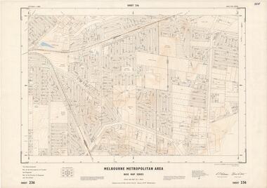
Map - Melbourne Metropolitan Area Base Map Series, Sheet 236 - Ringwood area, 1961
Map prepared by Dept of Lands and Survey and MMBW from State Aerial Survey June 1957 and Cadastral Survey information May 1961. This sheet comprises parts of the Municipalities of Croydon and Ringwood, and Parishes of Ringwood and Warrandyte.Scale: 400 feet to 1 inch. Contours at 5 feet vertical interval. By Authority: A.C. Brooks, Commonwealth Printer, Melbourne.