Showing 4601 items matching "school photos"
-
 Bendigo Military Museum
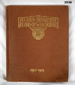
Book - BOOK, WAR SERVICE WW1, The Education Department's Record of Service Victoria 1914-1919, c.1921 - Forword dated 1.3.1921
From Forword: Contained in this book are the records of the work done by the schools of the Education Department of Victoria.Hard cardboard cover, orange buckram with gold print on front & spine. 304 pages, cut, faint speckled edge, white. Illustrated black / white photos & illustrations. End papers are dark brown. Handwritten in black ink on page before title page: “Sapper Henry J Collins”book, service, education department, victoria -
 Bendigo Military Museum
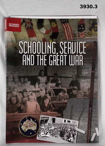
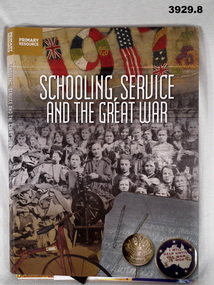
Education kit - EDUCATION KIT WW1, Schooling service and the Great War, 2015
... covers. Illustrated in colour, background, group photo... in colour, background, group photo of children at school desks, 2 ...Schooling, Service & The Great War. Secondary Resource. See also Reg No 3929.8.Schooling, Service & The Great War. .1) Soft cover book, cardboard with front fold out flap. White print on front / back covers. Illustrated in colour, background, group photo of children at school desks, 2 posters & embroidery. Inside of cover is colour photo of timber, leather satchel & papers. Spiral bound in black wire. 94 cut, plain, white pages. Illustrated black / white / sepia / colour photos. CD plastic pocket on front flap. .2) Paper poster, white print, college colour, black white photos, copy of book cover. .3) CD Rom, plastic. illustrated copy of book cover.education, kit, schools, ww1 -
 Bendigo Military Museum
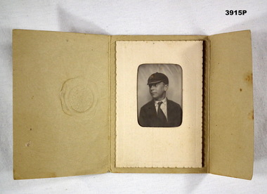
Memorabilia - PHOTOGRAPH, Preservene Pty Ltd
Item re Frederick Gardner DAVEY DFC No 410533 RAAF. Refer Reg No 3536P for his service details.Black / white portrait photo of a boy in school uniform, consisting of a shirt, tie, jacket & monogrammed cap. Photo is in a cream, card mount. Photo & mount are enclosed in a light brown embossed card folder.Printed on the front of the folder: With compliments PRESERVENE PTY LTDcards, photography -
 Bendigo Military Museum
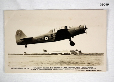
Card - POSTCARD, PHOTOGRAPHIC, RAAF Directorate of Public Relations
Item re Frederick Gardner DAVEY DFC No 410533 RAAF. Refer Reg No 3536P for his service details.Black / white photo postcard featuring an aircraft with RAAF markings.Printed in black below photo: DEFENCE SERIES No 140 "WACKETT" TRAINER: THIS STURDY TRAINER, DESIGNED AND BUILT IN AUSTRALIA IS NOW IN PRODUCTION FOR USE IN RAAF ELEMENTARY FLYING TRAINING SCHOOLS. Handwritten in blue in on back: Mrs I Davey Pres CWA Strathdalephotography, cards, raaf, training -
 Bendigo Military Museum
Education kit - EDUCATION KIT WW1, Schooling, Service and the Great War, 2015
Schooling, Service and the Great War Primary Resource. See also Cat No 3930..1) Book, soft cover, cardboard with front fold out flap, white print on front & back covers. Illustrated with colour background, group photo of children, embroidery & badges. Inside of cover is a colour photo of timber, leather satchel & papers. 82 cut, plain, white pages. Illustrated black / white / colour photos. Spiral bound, black wire. .2) Poster, paper, Schooling, Service and the Great War. Collage copy of book cover, colour photos. .3) Paper, paper, Australian War Memorial Education Services 2015. Black print, collage colour photos. .4) Poster, paper, Discovering Anzacs. Black print, black / white / colour collage photos. .5) Poster, paper, Anzac Day Schools Award 2015. Black print, black / white photo. .6) Poster, paper, Leadership and Legacy. Yellow print, colour photos. .7) Bookmark, paper, Gallipoli, The First Day. Black print, colour photos. .8) Erratum. Paper, black print for page 30.education, schools, kit ww1 -
 Bendigo Military Museum
Book - BOOK, WW1, Letters to Creswick
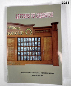
Letters to Creswick. A selection of letters published in the Creswick Advertiser during the Great War.Cover soft cardboard, black, red & white print on front. Background pale green with photograph in colour of the Creswick School, Roll of Honour in foreground. No page numbers. Illustrated with black & white photos. Cut plain white pages.books-military-history-collection, letters, creswick -
 Bendigo Military Museum
Book - BOOK WW2, Sun Books, Swastika at War, 1975
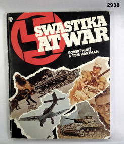
Book, paperback, page numbers not shown. Illustrated with colour & black & white photos. Front cover illustrated with a swastiker, white printing & a montage of 5 German photos with stylised torn edges.Kym Levett, C/- Peterborough Primary School, Peterboroughbooks, swastika, -
 Bendigo Military Museum
Book - PAMPHLET, SIGNAL WW2, Signal Training Vol III Switchboards UC 10 & 6 Line, c.1940
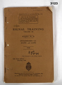
This is an Australian reprint of a British War Office Publication 21.5.1940. Item relates to Desmond Francis BOYLAN, enlisted initially as No S5441 then transferred to the 2nd AIF No SX20194 on 18.7.1942 age 27 years. He was discharged from the Army on 3.9.1946 with the rank of L/Sgt in 2/4th Armoured Regt.Brown soft cover, black printing. 56 pages, plus numerous circuits, black & white photos & a large quantity of glued in amendments.Handwritten top right of front cover: "High School Senior Cadet Detachment" Inside front cover: "SX 20194 CPL D T Boylan, HQ Sqn 9 Aust Motor Regt"books reference / military, signal, training -
 Bendigo Military Museum
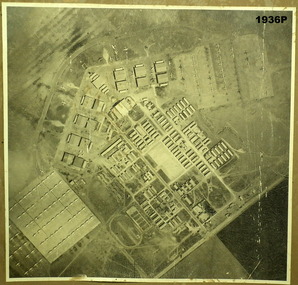
Photograph - PHOTOGRAPH RAAF WW2, 1939 - 1946
... photos Mallala On rear - "No. 6 Service Flying Training School ...Item in the collection re Maxwell Matheson RAAF. History of site written on rear of photo in biro.Air photo of RAAF base. Mounted on cardboard. No. 6 service flying training school, Mallala SA. Large writer description. Photo shows very large quantity of Avro Ansons, revetments & building.On rear - "No. 6 Service Flying Training School, RAAF, Mallala"photography, aerial photos, mallala -
 Federation University Historical Collection
Photograph - Image, Yarrowee Hall, Redan, c1883
ROBERT MALACHY SERJEANT (1828-1902) Robert Malachy Serjeant was born on 21 December 1828 at Callington, Cornwall. He was the son of Philip Davey Serjeant, a surgeon in the Royal Marines, and Eliza Malachy. Philip Serjeant died in 1834. His mother, Eliza, remarried John Burgh in 1836. He died in 1837. In September 1848 Eliza, Robert and his two sisters, Caroline and Susan, departed Plymouth on the William Moneya for Port Adelaide and arrived in January 1849. Once gold was discovered in Victoria, Serjeant made his way to Forest Creek (near Castlemaine) and he and his mate Mr Victor, were the first party to sink through the basalt in search of a deep lead. In 1854 he moved to Ballarat to work as a miner and enjoyed some success. In 1855 he was with a group that discovered a 500 ounce nugget. With his share of the sale he set himself up with the latest mining equipment, as well as beginning a lifelong interest in the share market. He became the Manager of the Chryseis, Isis and Garibaldi claims and then the Manager of the Band and Albion Consol Company. He held the position for thirty years and only resigned when the company amalgamated with the Sir Henry Loch Mine. Robert Malachy Serjeant became interested in Politics. The first election for Parliament Representatives for Ballarat was in 1855. Robert stood for election for the first time in 1859, representing Ballarat West. He was also elected to represent Ballarat West in 1874 and 1880. Robert Serjeant’s community involvement extended to Education. Years of discussion eventually saw the development of the Ballarat School of Mines, the first school of mines in Australia. The inaugural School Council was formed in 1870 with Sir Redmond Barry, the Chief Justice, as President and Robert Malachy Serjeant as a member of the council. He held a position on the council until illness forced him to retire in 1889. He was elected a Life Governor in 1889. He was also a Life Governor of the Ballarat Hospital. Robert Serjeant showed Prince Albert and Prince George (later King George V) around the Band and Albion Mine. At the age of 42, Robert enrolled as a student at the School of Mines in 1871. He obtained a Certificate of Competency in Assaying (including Metallurgy) in 1875. The first certificate in “Geology as Applied to Mining” was awarded to Robert Serjeant in 1876. Robert Serjeant was an active and generous supporter of the School of Mines. As well as being a financial contributor, he lectured and examined in the Principles and Practice of Mining. He was regarded as an authority on alluvial and quartz mining and was a member of the Ballarat Local Court and mining board. In 1977 Robert, Joseph Flude and Henry Caselli donated the patent rights of a novel Pyrites furnace to the school. The R.M. Serjeant Scholarship at the Ballarat School of Mines resulted after a reward was offered for the first to produce the best method of treating auriferous ores – other than the smelting method. The offer was open for two years but not awarded. The money for this was donated by Robert Serjeant to the amount of 256 Pounds. It was then used to fund the School of Mines Scholarship in Engineering (1889). It was first awarded in 1922. Robert Malachy Serjeant died on 25 October 1902 and was buried at the Ballaarat Old Cemetery. (Sometimes Malachy is incorrectly written as Malachi)An copy of a photo of Yarrowee Hall, the home of of mine manager Robert Malachy Serjeant. robert malachy serjeant, r.m. sergeant, robert malachi serjeant, band of hope and albion consols, yarrowee hall, redan -
 Federation University Historical Collection
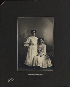
Photograph - Photograph - Black and White, Jas. Brown et al, Edith and Maud Yung and Yung Family, 1 1909
.7 Richard Henry Watson was Edith Emma Watson's (nee Yung) son. Edith Emma was also the mother of Alice Watson, artist and dressmaker, who trained at the Ballarat School of Mines in the 1930's. .1 Black and white photograph of two women, one standing and the one seated, on a grey background 1909 .2 Black and white photograph of a reverend and seven altar boys, on and dark cream background, within folder c1897 .3. First Confirmation Certificate, with prayer,1902 .4 Sepia photograph on cream background of young boy,1917 .5 Small black and white photograph with black border of young male .6 Black and white circular photograph of a woman and girl, on cream background postcard,1908 .7 Black and white photograph with white border of bride and bridesmaid,1946.1 Front: Celoron Cabinet, Edith and Maud Yung 1910. Versa: Nanna and Aunty Maud .2 Front: Rev Greenham + choir boys.Versa: 2nd from left is William John Yung (John) died at age 8 1897. Nhill, William Yung. John (second from left, died young aged 8 in Allendale. Parents John Yung and Mary Ann Sudweeks .3 Baptised Ethel Emma Yung; Confirmed 14th December 1902; First Communion 25th December 1902; Signed by C Allanby; A Daily Prayer (eight lines); Confirmed by Arthur(?) V Bishop of Ballarat. S.P.C.K. Riddle & Couchman Lith, London .4 Front bottom: Copies may be obtained. Melbourne Photographic company, *Bridge Street Ballarat*. Verso: G.A. Yung died at Ypres, Belguim 1917 .5 Front bottom:Willetts Elite Studio. RHS H. Yung. Verso: Elite Photographic Studio. Patronised by the Royal Princes and Suite. Special photographer to His Excellency the Govenor. Willetts Bridge Street Ballarat. Paper note with photo: Henry( Harrie) Yung ( George Edgar's brother) was born at Loch in Gippsland and became a railway worker. Richard Henry (Harry) Watson Edie Watson's (nee Yung) son was named after him. .6 Front: Lena and Ethel Yung Verso:Postcard: a note to her sister Miss E Yung Yendon from Lena Yung - "Dear Edie, Received PC(?) I don't know whether you know anyone here. This is Mother's cousin with me. She was up on holiday. Hoping you are all well. Love to all. I remain yours Lena." 1908. Pink postage stamp showing RAT 08 (Alice Watson, Murtoa) .7 Verso: Elite Photos 278 Flinders Lane Melbourne C.5540 Beryl Yung - bride Margaret Middleton - maid, 9th Feb 1946 POST Correspondence 4213 celeron cabinet, edith yung, reverend greenham, choir boys, john yung, william yung, mary sudweeks, nhill, allandale, ethol emma yung, c allanby, arthur b, h.yung, beryl yung, margaret middleton, elite photos, g a yung, willetts studio, elite photographic studio ballarat, confirmation certificate 1902, millinery, bride, bridesmaid -
 Federation University Historical Collection
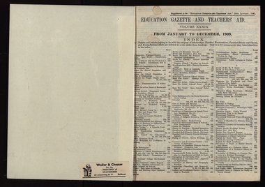
Book, Education Gazette, 1930s, 1930s
... (photo), Norsemen, Techncical Schools Exhibition, Knots... (photo), Norsemen, Techncical Schools Exhibition, Knots ...10 hard covered, black books with red spine. The books contain the bound Victoria Education Gazettes for the 1930s. .4) Handwork in rural schools, Young Farmers' Clubs, Domestic Arts, Arbour Day, LEague of Youth of Australia. Health Education, Metal Trades, Industrial Studies, HOrticulture, Hinkler Memoria Trees, Musical Appreciation, British Breeds of Sheep. Train Journey Through Germany, History Handwork - Roman Times, Claude Seareby (photo), Norsemen, Techncical Schools Exhibition, Knots, Balllarat Junior Technical School Terraced Gardenseducation gazette, ballarat junior technical school terrace gardens -
 Federation University Historical Collection
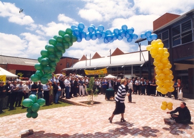
Photograph, Ballarat School of Mines Final Party, 1994, 12/1994
The time capsule includes newsletters, photos, a menu, medallions, a computer disk and a copy of the Ballarat Courier. The capsule was buried in a sealed PVC cylinder wrapped in plastic. A photograph of Pam Davies, Ballarat School of Mines Council President, about the release ballons at the 'SMB Final Party' which took place before the merger of the Ballarat School of MInes and the University of Ballarat. merger, pam davies, ballarat school of mines, party, time capsule, ballarat school of mines merger, council president -
 Federation University Historical Collection
Photograph - Photograph - black and white, Rubie Lonie
Ruby Lonie was Senior Clerk of the Ballarat School of Mines (SMB) Administrative Staff. Always known as Miss Lonie, her sole position was at SMB where she worked between May 1914 and May 1960. When the SMB Registrar, John Robinson, died in 1935 the question of who would fill the position became a matter of urgency. The temporary answer was Miss Lonie, who was the senior clerk on the Registrar's staff. The permanent position was looked upon as an exclusively male preserve. At Miss Lonie's retirement function SMB President, M.B. John, noted that Miss Lonie had joined the staff in 1914 and had 'done a tremendous job since that time, and for many years had been the Registrar's "Right Hand Man". Twenty Four years after having acted as Registrar the current SMB Registrar, F.F.Ferguson recognised Miss Lonie's assistance and her extensive knowledge of the history and the administrative procedures of the School. He added 'I have noted on many occasions Miss Lonie's kindly interest in people in times of sickness or difficulty and her willingness to help.' Current and former staff members were keen to acknowledge Miss Lonie. Former Principal Dick Richards said 'That Miss Lonie had been in this one job all her life is a great tribute to the school, and the Council is conscious of her devoted service.' The Principal, Mr Arblaster, on behalf of himself and the staff presented Miss Lonie with a gold watch and wished her well in her retirement. The next day Miss Lonie, along with Hestor Darby, the SMB Typewriting teacher who was on long service leave, sailed from Melbourne for London, mainly to visit Scotland.A black and white photo of a woman, Ruby Lonieruby lonie, ballarat school of mines, women, university women -
 Federation University Historical Collection
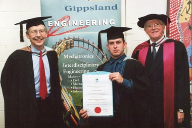
Photograph, Gippsland Campus Graduation, 05/2002
Two photos from a Monash University Gippsland Campus graduation. .1) Owen Townsend, double degree in Civil Engineering and Business .2) L-R Leon Soste (lecturer), Owen Townsend (Graduate) and Jim Jarvis (Head of Engineering School) If you can assist with infrormation on this photograph please use the email link below. gippsland campus collection, gippsland institute of advanced education, leon soste, owen townsend, jim jarvis, engineering -
 Federation University Historical Collection
Photograph, Delegates to the ANA Conference, 1947, 21/03/1947
Dysart is a Tudor Gothic building used as the original site of Geelong Grammar School. The Governor of Victoria, Sir Henry Barkly, laid its foundation stone in 1857 with the Bishop of Melbourne and the Archdeacon of Geelong in attendance. The student boarder population grew rapidly to call 55 Maud Street their home. After the school relocated to a larger site in 1914, the building was subdivided into a factory and a guesthouse called the Dysart Private Hotel. In 1961, it was again converted into the Reformed Theological College then later a private residence. In 2018 55 Maud Street had fallen into a state of disrepair, but was renovated to provide 28 premium dormitories in a peaceful and gorgeous setting.Small black and white photo.Verso "Taken oustise "Dysart" 21-3-47 Delegates ANA Conference 1947 Geelongana, australian natives association, geelong, dysart -
Federation University Historical Collection
Photograph, Ballarat School of Mines Student Drawing, pre 2004
... school Laminated colour photo of a student drawing Ballarat ...Laminated colour photo of a student drawingalumni, art, drawing, ballarat school of mines, ballarat technical art school -
Federation University Historical Collection
Photograph, Ballarat School of Mines Student in front of a computer, pre 2004
... Laminated colour photo of a Ballarat School of Mines... art computer tutor staffmember Laminated colour photo ...Laminated colour photo of a Ballarat School of Mines Student in front of a computerstudent drawing, with a tutor watching onalumni, art, computer, tutor, staffmember -
Federation University Historical Collection
Photograph, Ballarat School of Mines Students Stirring Ingredients in a Saucepan, pre 2004
... Laminated colour photo of a Ballarat School of Mines... hospitality chef cooking Laminated colour photo of a Ballarat School ...Laminated colour photo of a Ballarat School of Mines Student chefs cookingalumni, hospitality, chef, cooking -
 Bendigo Military Museum
Photograph - PHOTOGRAPH WW1, C.1916
The card relates to Robert Thomas Heard No 5105, KIA (standing on the right) Refer 1893.2P for his service history and other collection items. The other soldier is George Lyonel Henson No 4823 enlisted in the AIF on 8..7.1915 in the 14th reinforcements 6th Batt age 19 years 2 months. Embarked for Egypt 7.3.1916, transfers to 58th Batt 19.5.1916, embarks for France 21.6.1916, promoted to Sgt 3.7.1916, transfers to 57th Batt 29.8.1916. During 1918 he attends Musketry and Corps school totalling 5 weeks. WIA 28.9.1918 GSW’s multiple and DOW’s the same day. His name and Heards is remembered on the Soldiers Memorial Institute Roll Bendigo.Photo postcard, sepia tone showing two soldiers in uniform standing. Writing on rear in purple pencil.“Dear sister, this is a photo of us both, pretty poor photo. If you have time you might call on George’s mother in Queen St, Mrs Henson 170 Queen St Bendigo”. photographs, postcards, heard -
 Bendigo Military Museum
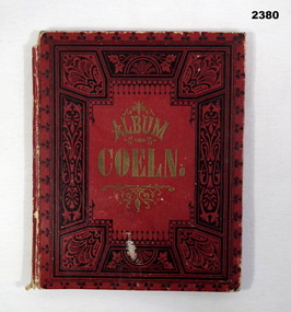
Album - ALBUM, CARD, Album von Coeln (Album of Cologne), Pre WW1
Sent by FRANK BARNES (AIF 4156) to UNA FRANKLING of Harcourt. Part of a collection covering 22 Catalogue site No’ s of postcards, photos and album relating to; Frank Barnes of Harcourt Vic. James Higgins of Newstead Vic. Thomas Comini of Harcourt Vic. To “Una Frankling” of Harcourt. Frank Barnes No 4156 enlisted in the AIF in 13th reinforcements 5th Batt on 28.7.1915 age 25 years. Embarked for Egypt 29.12.1915, embark for France 27.3.1916, promoted L/Cpl 27.3.1916, hospital 9.7.1916 with Influenza, rejoin unit 18.7.1916, WIA 27.7.1916 GSW left arm, rejoin unit 15.11.1916, promoted Cpl 23.11.1916, promoted L/Sgt 13.3.1917, hospital 20.4.1917 with PUO, rejoin unit 13.5.1917, to England 1.8.1917 for School of Musketry and Training Batt’s, promoted Sgt 5.10.17, rejoin unit 10.4.1918, hospital 20.6.1918 with Influenza, discharged from the AIF 18.9. 1919. James Edward Higgins No 3140 enlisted in the AIF in 7th reinforcements 23rd Batt on 28.7.1915 age 21 years. Embark for Egypt 26.11.1915, transfer to 58th Batt 23.2.1916, hospital 27.2.1916 (unclear) rejoin unit 15.3.1916, embark for France 17.6.1916, transfer to 15th Aust Light trench Mortar Battery, promoted to L/Cpl 26.1.1917, promoted Cpl 17.5.1917WIA 25.9.1917 SW’s right leg and ankle, DOW’s in 6th Aust Field Ambulance 27.9.1917. Thomas Comini No 4160 enlisted in the AIF in 13th reinforcements 5th Batt on 28.7.1915 age 23 years. Embark for Egypt 29.12.1915, transfer to 57th Batt 20.4.1916, embark for France 17.6.1916, WIA SW left wrist, rejoin unit 10.4.1917, discharged from the AIF 15.8.1919.Red, rectangular booklet with illustrations of Cologne pre WW1“Album von Coeln”documents - photographs, cologne -
 Bendigo Military Museum
Book - BOOK, MEMORIAL, The All-Australia Memorial Book (Vic Ed.), 1917
Pictorial book contains the names of Victorians K.I.A 1914 - 1916 and those who enlisted during the same period. Also stories and a list of bravery awards. Each book has a place for a photo inside The MULLER Brothers. Two of the three boys photos are in the book, Albert & Edgar. They All came from Nhill Victoria. Albert Herbert Muller No 448 enlisted in the 4th L.H.Regt C Sqd on 19.8.1914 age 21 years 7 months. Embarked for Egypt 19.10.14 and then to Gallipoli on 20.5.15, KIA by a sniper on 1.8.1915 at Gaba Tepe Gallipoli. Buried Shell Green Gully 2.8.1915. John Herman Muller No 1102 enlisted in 8th reinforcements 8th L.H Regt on 2.7.15 age 22 years, embarked for Gallipoli 20.8.1915, hospital with Mumps 25.10.15, return to unit 17.11.1915, embark for Alexandria 25.12.1915, hospital 16.9.1916 with Tonsilitis, WIA 19.4.1917 GSW to chest, left leg & arm, hospital 28.11.1917 with Diarrheoa, hospital 1.9.1918 (unclear), promoted T/Sgt 13.3.1919, discharged from the AIF 9.12.1919. Edgar Percy Muller No 3227 enlisted in 26th reinforcements 8th L.H.Regt on 9.11.1916 age 18 years 7 months. Attended Signal School 10.11.1916 to 14.2.1917, embarked for Egypt 20.2.1917, hospital 26.6.1917 with Debility, return to unit, WIA 1.12.1917 GSW to Chest, return to unit 9.1.1918, hospital 4.6.1918 with Malaria, return to unit 31.7.1918, hospital again 9.8.1918 (appears to be Malaria severe), return to unit 29.10.1918, discharged from the AIF 20.10.1919.Memorial Book Australia's Roll of Honour 1914 - 1916. History, Heroes and Helpers. Includes illustrations, photos, drawings, maps, portraits, personal records. Includes fold out pictures inside front cover. Photo and details of A. H. MULLER pasted onto first page. Gilt edged pages. Leather bound cover.books - military - reference, memorials -
 Bendigo Military Museum
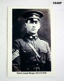
Photograph - PHOTOGRAPH WW1, Original Approx 1916 - 1917
Patrick Joseph Morgan was a big man for the times at 6 foot 3 and a half inches. He had 5 years service prior to enlisting in the AIF on Instructional Staff in 16th Light Horse with the rank of A/Staff Sgt. He enlisted in the AIF in 9th reinforcements B Coy 58th Batt with the rank of Sgt 16.2.1917 age 23 years 7 months. Embark for England 16.7.1917, embark for France 4.12.17, attend Musketry School 22.5.1918 - 30.6.1918, KIA 31.8.1918.B/W copy of original photo for display of Patrick Joseph Morgan in uniform wearing peak cap, Sam Brown, on sleeve 4 stripes. “Patrick Joseph Morgan K.I.A 31/8/1918”photography- photographs, morgan -
 Bendigo Military Museum
Artwork, other - BOOK, 1917
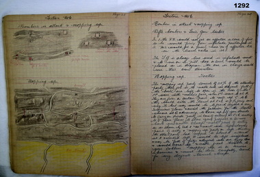
Part of the Grinton collection which included hundreds of negatives and developed photos taken by Jack Grinton during WW1. Refer Cat No 1280 for service details. Refer 1317P, 1320P.Black fabric covered exercise book with graph printed pages. Contains colour hand drawings, writing in ink relating to bombing, gas warfare, weapons, tactics etc. heading on page 4 with floral decoration "Bombing notes from the 2nd ANZAC B & JM School Morbecque 17/10/17, No 1043 L/Cpl JW Grinton 38th"On inside cover in ink: "No 1043 L/Cpl JW Grinton, C Company. 38th battalion 10th INF Brigade, 3rd Division AIF. C Coy Bombing and Gas NCO"military, war fare, pen and ink -
 Bendigo Military Museum
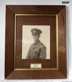
Photograph - PHOTOGRAPH, FRAMED, Pre WW1
Photo Herbert Booker FIELD as a Senior Cadet prior to WWI, he had 4 years in Senior Cadets. Herbert enlisted in the AIF on 26.6.1917 age 18 years in the 25th Reinforcements 14th Bn No 7596, embarked for England 21.11.1917, disembark 5.1.1918, attends 4th Div Signal School, embarks for France 29.7.1918 to reinforce 13th Bn, RTA 1.11.1919, discharged from the AIF 14.1.1920. He enlists in the CMF on 3.5.1939 No V1629, appointed Lt 3.12.1937, transfers to the 2nd AIF 10.9.1942 as VX104280, joins the Interim Army 1.7.1947 till 7.6.1948, appointment terminated with the rank of Lt Col. Awarded the "Efficiency Decoration"Frame, brown stained timber with gold inner edge also decorated with copper wire. Timber mount with glass. Photo, black & white of a soldier in uniform, half portrait of H B FIELD. He is in his Cadets uniform. Handwritten in blue ink on brown paper on back of frame: “Mrs J E McCrystal” In Red ink: “Prior to enlisting WWI Senior Cadets 2nd Lt 67B. 1st AIF HB FIELD PTE 7596 13th Aust Inf Btn. 2nd AIF VX104280 HQ 8th Command Quartermaster General (not in notes) On white label: "H B FIELD As a Senior Cadet prior to WWI. No 7596 13th Batt AIF' No VX104280 2nd AIF. Donated by Mrs J E McCrystal"photography-photographs, frame accessories, cadets, 67th -
Federation University Historical Collection
Photograph, Ballarat School of Mines TAFE Graduation
... Photos of the Ballarat School of Mines TAFE Graduation... Virginia Fennelon Janet Dore Photos of the Ballarat School of Mines ...This graduation was held in the Lydiard Street Uniting Church.Photos of the Ballarat School of Mines TAFE Graduationballarat school of mines, tafe, graduation, lydiard street uniting church, e.j.t. tippett outstanding achievement award, robert bryan, ann lentrice, alistair highway, david caro, michael adderman, david james, virginia fennelon, janet dore -
 Federation University Historical Collection
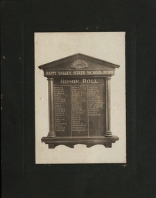
Photograph, Happy Valley State School No.376 Honor Roll, c1920
World War One honor roll of former students of the Happy Valley State School No 376 who enlisted. The original honor roll no longer exists. There is a framed photograph of it in the current Happy Valley School building now used for community events. This honor roll would appear to be made before the end of WW1 as Ernest Alfred Yung died in September 1917 at Ypres. His brother George Alfred Yung returned who was also in the same battle returned to Australia. Honour rolls were also made to encourage more men to enlist. Margaret Young studied at Ballarat West Art School in 1894. This was one of Ballarat's Art schools. In 1907 they merged and became Ballarat Technical Art School (BTAS). Margaret became a teacher and taught for many years at BTAS, specialising in woodcarving. At the end of the First World War, Honour Boards were requested to be made to honour the men who had served. Ballarat was the main provider of these boards. Margaret Young was one of the people responsible for the carvings and specially mentioned for her work by the Caulfield School in Melbourne. On her resignation, Margaret moved to Adelaide. At the past students Reunion Celebrations in 1930, Margaret Young was to be the Guest of Honour. Unfortunately she was unable to attend due to ill health. Sepia photograph of honor roll board for World War One with white background mounted on grey cardboardReverse lhs upper - inked words 'Photo only'; centre - 'Mrs J Garvey, Happy Valley'; rhs upper - two stamps, 1 penny and a half penny franked with Ballarat; pencilled writing 'Mrs Garvey Happy Valleyhappy valley, happy valley state school, honor roll, honour roll, o. brough, e. daniels, g. daniels, philately, j. dial, g. dial, a. gradnor, w. gradnor, g. kiely, a. kerr, w. lowe, l. martinez, h. martinez, j. milburn, c. milburn, a. may, e. morgan, f. opie, a. paterson, n. reid, f. rankin, h. smith, t. thomas, l. thomas, e. yung, a. yung, a. bromley, j. blundell, h. barraclough, j. crommie, g. darling, j. darling, w. w. groves, j. gardiner, a. keys, j. keys, p. kelly, s. kelly, m. morgan, w. montgomery, j. rutherford, r. rutherford, p. smith, w. wishart, h. wark, s. ronald, k.n. mcnamee, p. bennington, sister m.j. thomas, d.l. thomas, w.e. thomas, j.s. gower, f.h. gower, s. gower, s.t.m. gower, happy valley school honor roll, a.a. louden -
 Federation University Historical Collection
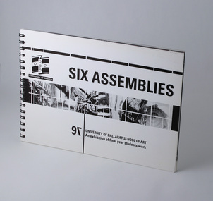
Booklet - Exhibition Catalogue, Six Assemblies, University of Ballarat, School of Art, 1997
Foreword by Associate Professor Robert L Allan, Head, School of Arts, University of Ballarat. Information regarding travel awards by Anne Saunders. Book sectioned by study areas, including photos of students, contact details and an example of their work. Final page includes list of sponsors, award donors, exhibition committee and designers.Catalogue accompanying exhibition of final year, Visual Arts student work at University of Ballarat, 1997. Spiral bound landscape book, 36 leaves (72pp) plus card covers front and back. Single colour black and white print throughout.university of ballarat, federation university, ceramics, drawing, graphics, graphic design, printmaking, sculpture. -
Federation University Historical Collection
Booklet - Booklet - Prospectus, McCarron, Bird and Co. Printers, Collins Street, Melbourne Junior Technical School, Prospectus,1914, 1915
Used at Ballarat School of Mines and Industries. The Melbourne Junior Technical School opened in 1912. It was a School for Junior Technical Work in Science, Art and Trade.` Information about aim of school, constitution, council, day courses, scholarships, holidays, evening courses, regulations, rules, sports, staff, students and syllabus.Light green covered booklet with gold crest with photo of The Melbourne Junior Technical School. 56 pages. Information about aim of school, constitution, council, day courses, scholarships, holidays, evening courses, regulations, rules, sports, staff, students and syllabus. melbourne, melbourne junior technical school, prospectus, john lemmon, t.j. greenway, d. avery, a.w. craig, c. gray, c.a. hack, wilfrid.n. kernot, a.h. merrin, h. payne, w.c. scurry, p. mccormack, principal, councillors, staff, trades, w bruce, head of department, r hudspeth, c greehill, j russell, r kinross, c juncken, a b lundy, a dunstan, mathematics, e j lewis, d j morris, english, g m nicholas, m samuel, science, r a white, j e jones, art, w gilmore, e thompson, physical culture, a j hauser, w d wilson -
Federation University Historical Collection
Book - Book - Scrapbook, Ballarat School of MInes: Scrapbook of Newspaper Cuttings, Book 9, August 1980 to January 1981
Collection of newspaper articles related to Ballarat School Of Mines.They cover activities and advertisements for staff. The papers concerned are The Courier, Ballarat, The Australian, The Age over the period of 09/08/1980 to 15/01/1981.Book with white cover back, front, spiral bound. staffing advertisements, courses available, metal trades industry association award, stephen jackson, unemployed youth program, majority didn't like school, motor mechanic apprentice brendan nunn, racv award, women's conference, secretarial careers day at smb, department of labor and industry, safety award to sec apprentice ross homberg, theatre group needs more members, challenging forum-ballarat melbourne rail link, role of councillors, bricklaying apprentices given tool kits, sir redmond barry, the man who sentenced ned kelly to death, bricks sale to aid smb building, ballarat sandblasting, o'flaherty, smb recreationbuilding appeal, smb link with barry centenary, smb art display, smb 110th birthday, bcae is 10 years old today, decade of growth at smb repeated 100 years later, intensive course for apprentices, priceless relics gather dust, aboriginal world war 1 collection, smb land laboratory opening, lee anton wins photo prize, students moving from tafe college to tertiary education, smb council move for tafe centre, engineering course change defended