Showing 4029 items
matching surveying-terrestrial
-
 Melbourne Tram Museum
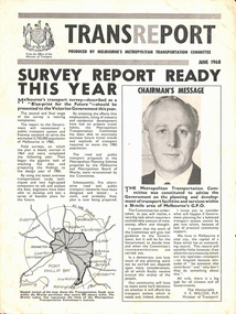
Pamphlet, Minister of Transport, Transport, Jun. 1968
Transport - produced by Melbourne's Metropolitan Transportation Committee. 4 page brochure describing Melbourne's transport survey - "Blue-print for the Future".trams, tramways, reports, planning -
 Ringwood and District Historical Society
Photograph, Composite Aerial Views of Ringwood, Victoria - 1972
Two composite black & white aerial photographs with north-facing view over Maroondah Highway, including Railway Station precinct, Civic Centre precinct, Eastland, Mount Dandenong Road, Bedford Road, Ringwood Street, Warrandyte Road, Mullum Road, Loughnan's Road.Department of Crown Lands and Survey. Maroondah Highway Project - Run 3 - 20.1.72 - 3,900' ASL. -
 City of Moorabbin Historical Society (Operating the Box Cottage Museum)
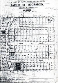
Flyer - Garfield Estate, Ormond
At the end of World War One, there was a renewed interest in residential land and a number of estates opened up in the Municipality of Moorabbin.Example of the progress of the Municipality of MoorabbinPhotocopy of the plan of the Garfield Estate, OrmondPart f Dendy's Crown Special Survey - parish of Moorabbin - County of Bourke - Garfield Estatedraper street, lord street, hudson street, blackshaw street, tucker road, ormond, mckinnon, real estate -
 Bendigo Historical Society Inc.
Map - JACK FLYNN COLLECTION: SALISBURY, 1965
Map: Parish of Salisbury, County of Bendigo. Parish plan.By Authority A. C. Brooks Government Printer, Melbourne. Drawn and Reproduced at the Department of Lands and Survey, Melbourne.map, bendigo, parish plan, salisbury -
 Bendigo Historical Society Inc.
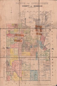
Map - JACK FLYNN COLLECTION: SHELBOURNE, 11/02/1937
Map: Parish of Shelbourne, County of Bendigo. Parish plan.By Authority, H. J.Green, Government Printer. Drawn and Reproduced at the Dept, of Lands and Survey, Melbourne, Victoria.map, bendigo, parish plan, shelbourne -
 Bendigo Historical Society Inc.
Map - JACK FLYNN COLLECTION: MUSKERRY, 1962
Map: Parish of Muskerry, County of Rodney. Parish plan.By Authority: A.C. Brooks, Government Printer, Melbourne. Drawn and reproduced at the Department of Lands and Survey, Melbournemap, rodney, parish plan, muskerry -
 Bendigo Historical Society Inc.
Map - JACK FLYNN COLLECTION: HAYANMI, March 1953
Map: Parish of Hayanmi, County of Bendigo. Parish plan.By Authority: W.M. Houston, Government Printer. Drawn and reproduced at the Dept, of Lands and Survey, Melbourne, Victoriamap, bendigo, parish plan, hayanmi -
 Bendigo Historical Society Inc.
Map - JACK FLYNN COLLECTION: GIRGARRE, 14/10/1943
Map: Parish of Girgarre , County of Rodney. Parish plan. Same map as 10100.20 but in poorer condition.By Authority, H.E.Daw, Government printer Melbourne. Drawn and Reproduced at the Dept, of Lands and Survey, Melbourne, Victoriamap, rodney, girgarre, girgarre, county of rodney -
 Bendigo Historical Society Inc.
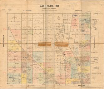
Map - JACK FLYNN COLLECTION: YARRABERB, 2/03/1931
Map: Yarraberb, County of Bendigo. Parish plan.By Authority H.J. Green Govt., Printer. Photo Lithographed at the Department of lands and Survey Melbourne, 2.3.31.map, bendigo, parish plan, yarraberb -
 Bendigo Historical Society Inc.
Map - JACK FLYNN COLLECTION: BEALIBA, 15/09/1931
Map: Parish of Bealiba, County of Gladstone. Parish plan.By Authority H.J. Green, Government Printer. Photo Lithographed at the Government of Lands and Survey Melbourne. 15.9.31map, gladstone, parish plan, bealiba, gladstone -
 Bendigo Historical Society Inc.
Map - JACK FLYNN COLLECTION: BET BET, 18/08/1931
Map: Parish of Bet Bet, Counties of Gladstone and Talbot . Parish plan.By Authority H.J. Green Govt, Printer. Photo Lithographed at the Department of Lands and Survey, Melbourne. 18.8.31map, gladstone, parish plan, bet bet, counties of gladstone and talbot. -
 Bendigo Historical Society Inc.
Map - JACK FLYNN COLLECTION: YARRAYNE, 6/01/1932
Map: Parish of Yarrayne, County of Bendigo. Parish plan.By Authority, H.J. Green, Govt., Printer. Photo-Lithographed at the Department of Lands and Survey, Melbourne. 5.1.32.map, bendigo, parish plan, yarrayne -
 Stawell Historical Society Inc
Map - Parish Map, Barkley County of Kara Kara 1920's, 1920's ?
Johnsons Gully LeadPaper map of Parish of BarkelyBy Authority H.J. Green Govt Printer. Photo Lithographed at the Department of Lands and Survey. Melbourne 22.11.2survey -
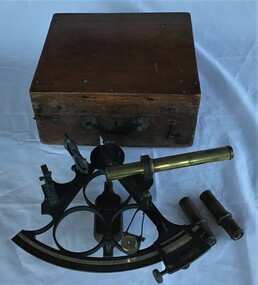 Queenscliffe Maritime Museum
Instrument - Sextant in wooden box
Sextant used by J P Larken, Government Marine SurveyorThe sextant has been the primary position fixing tool of the marine surveyor for 200 years used to measure angles between beacons or points for hydrographic surveys. A sextant in its own wooden box.On inside box lid; 'A. E. Parson surveying and scientific instrument maker, Queen Street, Melbournesextant, jp larken, marine surveyor -
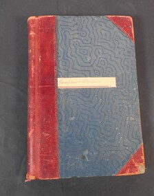 Bendigo Historical Society Inc.
Administrative record - Lands Office Bendigo - Exemptions and Applications
Blue and red hardcover book containing pages of handwritten entries of exemptions and applications to purchase land at various places. The book covers the years 1937 to 1939."Exemptions and Applications" handwritten on label on front cover. Attendance, Lands & Survey in gold letters on the spine.land office, government, land purchases -
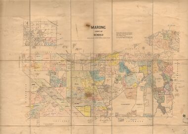 Bendigo Historical Society Inc.
Map - JACK FLYNN COLLECTION: MARONG, June 1933
Map: Parish of Marong, County of Bendigo. Parish plan.By Authority W.M. Houston, Government Printer. Drawn and reporduced at the Dept., of Lands and Survey, Melbourne, Victoria.map, bendigo, parish plan, marong -
 Bacchus Marsh & District Historical Society
Map, Mouyong Parish Map, County of Grant
A single page paper map showing the map for the Parish of Mouyong in the County of Grant. Cadastral map showing land ownership. The map is pasted into a bound volume containing 76 maps or plans in total. High resolution digital image stored on BMDHS computer network. Photo lithographed at the Department of Lands and Survey Melbourne by T. F. McGauran, 9. 4. 07mouyong parish plan, mouyong parish maps, bacchus marsh region parish plans -
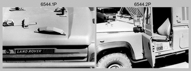 Bendigo Military Museum
Photograph - 4th Field Survey Squadron - Land Rover Perentie Light Vehicles, Keswick Barracks, Adelaide SA, 1987
This is a set of 35 photographs featuring 4th Field Survey Squadron’s newly introduced Survey variant of the Land Rover Perentie light vehicle, at Keswick Barracks, Adelaide SA in 1987. The Land Rover Perentie is a nickname for the Land Rover 110 produced by JRA Limited for the Australian Army, and part manufactured and assembled in Moorebank, New South Wales, during the 1980s and 1990s The name Perentie originates from Land Rover's successful tender to Project Perentie, which was the official Australian Army trial to select new 1 and 2-tonne light vehicles to replace the ageing fleet of Series 2A and 3 Land Rovers. The major differences between the Land Rover Perentie and British Land Rovers were the relocation of the spare wheel to a position under the rear of the load area, a galvanised chassis and the Isuzu engine. The Land Rover Perenties were produced in 4x4 and 6x6 variants and powered by an Isuzu 3.9-litre four-cylinder 4BD1 diesel engine. The Truck, Panel, Lightweight, Survey, FFR, Winch, MC2 model was one of eight 4x4 variants built for the Australian Army. There were 35 vehicles built to satisfy the operational requirements of RA Svy’s units. Source – Wikipedia. See item 6545.9P for related photos of these vehicles.This is a set of 35 photographs featuring 4th Field Survey Squadron’s newly introduced Survey variant of the Land Rover Perentie light truck vehicle, at Keswick Barracks, Adelaide SA in 1987. The black & white photographs are on 35mm negative film and are part of the Army Survey Regiment’s Collection. The photographs were scanned at 96 dpi. .1) to .8) - Photo, black & white, 1987. Land Rover Perentie light truck vehicle features. .9) - Photo, colour, 1986. L to R: unidentified, RQMS - WO2 Peter Symmans, unidentified. .10) to .15) - Photo, black & white, 1987. Land Rover Perentie light truck vehicle features. .16) - Photo, black & white, 1987. Land Rover Perentie light truck vehicle. L to R: WO2 Russ Larsen, SSGT Barry Lutwyche, 2IC Terry Lord, SGT Mick Hogan, unidentified. .17) - Photo, black & white, 1987. Land Rover Perentie light truck vehicle features. .18) & .19) - Photo, black & white, 1987. Loading field trip stores into Land Rover Perentie light truck vehicle. .20) & .21) - Photo, black & white, 1987. L to R: SPR Steve Perks, SGT Mick Hogan loading field trip stores into Land Rover Perentie light truck vehicle. .22) to .25) - Photo, black & white, 1987. L to R: SPR Steve Perks loading field trip stores into Land Rover Perentie light truck vehicle. .26) - Photo, black & white, 1987. CAPT Danny Galbraith loading field trip stores into Land Rover Perentie light truck vehicle. .27) to .31) - Photo, black & white, 1987. Loading field trip stores into Land Rover Perentie light truck vehicle. .32) to .34) - Photo, black & white, 1987. Land Rover Perentie light truck vehicle – broken transfer case lever. .35) - Photo, black & white, 1987. Land Rover Perentie light truck vehicle’s Isuzu 3.9-litre four-cylinder 4BD1 diesel engine..1P to .35P – There are no personnel identified. ‘PERENTI MOTOR VEHICLES JUL 87’ annotated on negatives sleeve.royal australian survey corps, rasvy, 4 fd svy sqn -
 Flagstaff Hill Maritime Museum and Village
Document - Navigation Chart, Admiralty Office, Lady Bay and Warrnambool Harbour, 1893
This navigation cart of Lady Bay and Warrnambool Harbour was originally surveyed in 1870 but this version includes the update for magnetic variation in 1893. Since the printing of the chart several annotations have been added. These include an additional stamp dated 15-8-1910, a handwritten comment across the top of the page dated August 1910, and another handwritten comment regarding the ‘Proposed Extension of Dock’ dated 19-2-1925, plus connected drawings, notes and figures. The 1925 proposal on this chart may have been a reaction to the Royal Commission of 1923, when the damaged stonework on the seaward side of the Warrnambool Breakwater, caused by the action of the sea, was the subject of enquiry. A conference between the Public Works, Water Commission and the Harbour Trust concluded that it would less costly to make repairs to prevent further damage rather than replaced the damage portion of the wall. A contract was raised in late 1924 to deposit rubble on the damaged side of the breakwater to minimise the Southern Ocean’s destructive action and work had started by August 1925. The Breakwater construction had begun in 1874 and was completed in 1890. The Victorian Government had commissioned Sir John Coode, a British harbour engineer, to present a plan to complete the Warrnambool Breakwater but his original plan was too expensive. He prepared a revised plan for a shorter structure. The construction proved to be too short to protect adequately from the weather and didn't allow enough depth for larger vessels to come into port. The decreasing trade was further affected by siltation in the bay due to the breakwater, and the completion of the railway line. The situation of the harbour became a real problem by 1910 and required continuous dredging. In 1914 the Breakwater was extended but proved to be a failure because the work began to subside and by 1920 about two thirds of the harbour was silted up. Alterations made in the 1920's increased the silting problem and by the 1940's the harbour was no longer used. More alterations were made in the 1950's and 1960's. This chart is significant for its strong connection to the maritime history of Warrnambool Harbour and Lady Bay and the Warrnambool Breakwater. The Warrnambool Breakwater is registered as a place of significance on the Victorian Heritage Database (VHR H2024). The Warrnambool Breakwater is one of the most important late 19th century maritime engineering projects in Victoria and significant in the development of Victorian coastal shipping. It is also significant for its connection with British harbour engineer, Sir John Coode. The chart is a historical record of structures existing in 1893; the Warrnambool Jetties, Warrnambool Breakwater in Lady Bay, the leading lights (lighthouses), streets, roads, bridges and many buildings. It also shows the lay of the land and seabed. Navigation Chart: Lady Bay and Warrnambool Harbour, Australia - South Coast - Victoria. Surveyed by Nav. Lieut. H.J. Stanley, R.N., 1870. Updated for Magnetic Variation, 1893. The rectangular chart is printed on heavy cream paper. Stamps are shaped rectangular, oval and round. Around the Breakwater and Jetty area are handwritten notes, dotted and joined lines, numbers and signatures, and shading of red and green. The chart shows the surrounds of Warrnambool Harbour, Lady Bay, the Breakwater and Jetty, roads, bridges and the streets in Warrnambool. It has sounding details, and angles of line from the leading lights.Stamp, rectangular, including "AUG 1910" Stamp, double oval " - - - -CHART" Stamp, hand drawn, red circle, with "B" inside Hand written note "22-8-1910 - - - - - of surveying C. Ca - - - request of 15-8-10 [initials] " Notes and lines in red pen, including a grid of sounding numbers: "1300" "1050" "1200" "Possible Extension of Dock" "19-2-25" "Dock Dredged to 20 Ft" Notes and lines in blue pen "Extension of Dock to accommodate vessels drawing 20 Feet" and "Light not visible south of this line" Red dots (4) with yellow highlight at both leading lights, breakwater and jettyflagstaff hill, warrnambool, flagstaff hill maritime museum & village, maritime museum, maritime village, shipwreck coast, map, chart, navigation chart, plan, lady bay, warrnambool harbour, port of warrnambool, breakwater, jetty, pier, dock extension, proposed extension, vhr h2024, 1870, 1893, 1910, 1925, warrnambool town late 1800s, warrnambool streets late 1800s royal commission, 1923, public works, water commission, harbour trust, victorian harbours, sir jon coode -
 Bendigo Military Museum
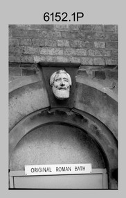
Photograph - Army Survey Regiment Personnel and Equipment, Fortuna, Bendigo, 1992
This collection of 15 photos of personnel and equipment was taken at the Army Survey Regiment, Fortuna, Bendigo, in 1992. The photos feature the inside Lithographic Squadron, external buildings, the transport compound, and the gardener’s end of the duty hut. Although these photos are not annotated most personnel are positively identified. Photos .14) to.15) feature Neil Morgan, who was a permanent ground maintenance employee.This is a set of 15 photographs of personnel and equipment at the Army Survey Regiment, Fortuna, Bendigo, 1992. The photographs are on 35mm negative film and were scanned at 96 dpi. They are part of the Army Survey Regiment’s Collection. .1) - Photo, black & white, 1992, outside Litho’s BARCRO work area (old entrance to Roman Bath) .2) - Photo, black & white, 1992, SPR Scott Cameron outside the Old OR’s Barracks. .3) - Photo, black & white, 1992, bank of the lake with Old & New OR’s Barracks. .4) - Photo, black & white, 1992, unidentified outside Q-Store buildings. .5)- Photo, black & white, 1992, records building under construction. .6) - Photo, black & white, 1992, ITEC type setter. .7) and .8) - Photo, black & white, 1992, ITEC type setter and IGX printer. .9) - Photo, black & white, 1992, IGX printer. .10) - Photo, black & white, 1992, Pakotone photographic processor. .11) - Photo, black & white, 1992, densitometer. .12) and .13) - Photo, black & white, 1992, unidentified RACT personnel in transport compound. .14) to.15) - Photo, black & white, 1992, Neil Morgan readying the ride-on lawn mower at rear end of Duty Hut. No personnel are identified.royal australian survey corps, rasvy, army survey regiment, army svy regt, fortuna, asr, litho -
 Bendigo Historical Society Inc.
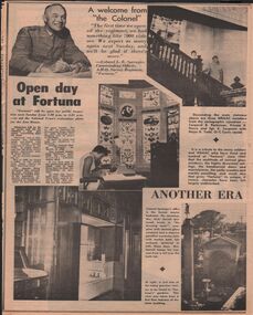
Newspaper - LYDIA CHANCELLOR COLLECTION: FORTUNA
A two page article from the Bendigo 'Advertiser' on 'Open Day at Fortuna.' Apart from information about Fortuna it includes photographs of some of the rooms at Fortuna including the Royal Australian Survey Corp's AHQ Survey Regiment mapping room. It also has other photographs within the house and in the grounds. 7/4/1970.bendigo, buildings, fortuna villa, lydia chancellor collection, collection, fortuna, homestead, house, houses, building, buildings, ahq survey regiment, royal australian survey corps, mapping, bendigo, fortuna employees, printing, army, colonel l. b. sprenger, national trust, george lansell, lansell family, heritage, place, house. houses -
 Bendigo Historical Society Inc.
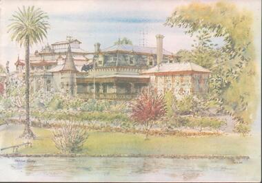
Card - FORTUNA COLLECTION: CARD
Christmas cards ( X 2) - sketched colour print with view of Fortuna Villa, palm tree on left hand side and partial view of lake in foreground. Writing inside card reads ' Best Wishes for Christmas and the New Year' and on the back of the card is a 'Royal Australian Survey Corps' insignia & the words 'Army Survey Regiment' -
Kew Historical Society Inc
Archive (Sub-series) - Subject File, Kew Historical Society, HODDLE Survey, 1997
Various partiesReference, Research, InformationSecondary Values (KHS Imposed Order)Photocopied correspondence and maps (surveys) relating to surveys ordered by Robert Hoddle, Government Surveyor. Authors of letters and information include Gwen McWilliam and Jack Hackett. Much of the correspondence relates to the site of the ‘Hoddle Tree’, currently located in the Kew Golf Course. Jack Hackett’s original map is contained in the map drawers in the Society’s archive.kew historical society - archives, kew (vic) - history, robert hoddle - surveyor, hoddle tree - kew (vic), jack hackettkew historical society - archives, kew (vic) - history, robert hoddle - surveyor, hoddle tree - kew (vic), jack hackett -
 Bendigo Military Museum
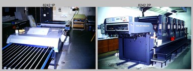
Photograph - Print Troop Equipment, Lithographic Squadron – Army Survey Regiment, Fortuna, Bendigo, c1990s
This is a set of 25 photograph of Print Troop Equipment in Lithographic Squadron, Army Survey Regiment at Fortuna, Bendigo, 1990. Photo .1P features the new Howson Algraphy Autoneg printing plate processor. It improved quality control and efficiency and allowed the conversion of printing plates for positive or negative use. The Heidelberg Speedmaster 102 shown in photos .2P to .4P was a computer-controlled five colour lithographic offset printing press. It provided the Royal Australian Survey Corps a vastly improved printing capability, as the five colours for a standard topographic map was printed in a single pass. The print room housing the Speedmaster printing press was named Wayzgoose Hall after a medieval printing house festival. Wayzgoose Hall and the Speedmaster printing capability was commissioned by the Commander of the 3rd Military District BRIG P. Davies AM, ADC on Wednesday 27th June 1990. This occasion is covered in more detail in page 145 of Valerie Lovejoy’s book 'Mapmakers of Fortuna – A history of the Army Survey Regiment’ ISBN: 0-646-42120-4. For additional photos, refer to item 6062.4P for more photos of the Heidelberg Speedmaster printing press. The Print Room’s Map Assessment and Colour Evaluation Stations in photos .5P to .12P provided the Printer Technician suitable viewing environments to perform quality assessments of map samples. See item 6151.34P for more information and photos of technicians using the equipment. The Print Room’s Map Handling Station in photo .15P to .20P provided ergonomic benefits to the Printer Technician and improved despatching productivity. See Item 6070.9P for more information and photos. The Wohlenberg MCS-2 guillotine seen in photos .21P & .22P was a heavy-duty guillotine integrated component of the Map Handling Station, to trim bulk printed map stock. See item 6069.6P for more information and photos of earlier types of guillotine equipment. This is a set of 25 photograph of Print Troop Equipment in Lithographic Squadron, Army Survey Regiment at Fortuna, Bendigo, 1990. The photographs are on 35mm colour slides and were scanned at 96 dpi. They are part of the Army Survey Regiment’s Collection. .1) - Photo, colour, c1990s, Howson Algraphy Autoneg printing plate processor .2) to .4) - Photo, colour, 1990. Heidelberg Speedmaster 102 computer-controlled five colour lithographic offset printing press .3) to .10) - Photo, colour, c1990s, Heidelberg Speedmaster CPC 1-04 control unit. .11) to .12) - Photo, colour, c1990s, Map Colour Evaluation Work Station. .13) to .14) - Photo, colour, c1990s, Linear printing plate registration punch. .15) to .20) - Photo, colour, c1990s, Print Room’s Map Handling Station. .21) to .22) - Photo, colour, c1990s, Wohlenberg MCS-2 guillotine. .23) - Photo, colour, c1990s, Print Room Power supply equipment. .24) to .25P - Photo, colour, c1990s, Print Room Crown Fork Lift..1P to .25P - There are no annotations stored with the 35mm slides.royal australian survey corps, rasvy, army survey regiment, army svy regt, fortuna, asr, printing, litho -
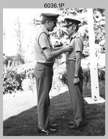 Bendigo Military Museum
Photograph - Army Survey Regiment - Defence Force Service Medal Presentations, Fortuna Villa, Bendigo, 1982
This is a set of eight photographs of Defence Force Service Medal presentations by LTCOL Peter Eddy, the Commanding Officer of the Army Survey Regiment, Fortuna, Bendigo on the 8th of November 1982. On this occasion the Defence Force Service Medal was presented to LT Keys (ARES), SGT Alan Timcke (ARES), SSGT L. Davidson and WO2 Kevin MacQuire for 15 years of efficient remunerated service in the Australian Army. LTCOL Peter Eddy was the CO of the Army Svy Rgt from 1981 to 1982. The photos were taken next to the flagpole in Fortuna Villa’s front garden.This is a set of eight photographs of Defence Force Service Medal presentations by the Commanding Officer of the Army Survey Regiment, Fortuna, Defence Force Service Medal Bendigo on the 8th of November 1982. The photographs were printed on photographic paper and are part of the Army Survey Regiment’s Collection. They were scanned at 300 dpi. .1) & .2) - Photo, black and white, 1982. L to R: CO LTCOL Peter Eddy presents the Defence Force Service Medal to LT Keys (ARES). .3) & 4) - Photo, black and white, 1982. L to R: CO LTCOL Peter Eddy presents the Defence Force Service Medal to SGT Alan Timcke (ARES). .5) & .6) - Photo, black and white, 1982. L to R: CO LTCOL Peter Eddy presents the Defence Force Service Medal to SSGT L. Davidson. .7) & .8) - Photo, black and white, 1982. L to R: CO LTCOL Peter Eddy presents the Defence Force Service Medal to WO2 Kevin MacQuire. .1P to .14P – no annotationsroyal australian survey corps, rasvy, army survey regiment, army svy regt, fortuna, asr -
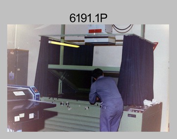 Bendigo Military Museum
Photograph - Lithographic Technicians operating printing plate processor at the Army Survey Regiment, Fortuna Villa Bendigo, c1990s
These 12 photographs were most likely taken in the 1990s in Lithographic Squadron at the Army Survey Regiment, Fortuna, Bendigo. In photos .1P and .2P the Printing Technician is placing a map negative or positive on top of the printing plate in a vacuum frame before light exposure. Photos .3P to .9P and .12P feature the new Howson Algraphy Autoneg printing plate processor. It improved quality control and efficiency and allowed the conversion of printing plates for positive or negative use. Processed printing plates were checked as shown in photos .10P and .11P before their installation on the printing press.This is a set of 12 photographs of lithographic technicians operating a new printing plate processor at the Army Survey Regiment, Bendigo c1990s. Photos .1P to .11P are on 35mm negative film and scanned at 96 dpi. Photo .12P is printed on photographic paper and scanned at 300 dpi. They are part of the Army Survey Regiment’s Collection. .1) to .2) - Photo, colour, c1990s, unidentified technician preparing printing plate in a vacuum frame. .3) to .7) - Photo, colour, c1990s, unidentified technicians operating new printing plate processor. .8) - Photo, colour, c1990s, L to R: CPL Mark Doherty, unidentified technician, LCPL John Bateman operating new printing plate processor. .9) - Photo, colour, c1990s, LCPL John Bateman operating new printing plate processor. .10) to .11) - Photo, colour, c1990s, LCPL John Bateman checking printing plate after processing. .12) - Photo, colour, c1990s, SSGT Russ Mollenhauer operating new printing plate processor. .1P to .12P – there is no annotations.royal australian survey corps, rasvy, army survey regiment, army svy regt, fortuna, asr, litho -
 Bendigo Military Museum
Photograph - Photographic Technicians performing tasks at the Army Survey Regiment, c1970s
These eleven photographs were most likely taken in the 1970s in Lithographic Squadron at the Army Survey Regiment, Fortuna, Bendigo. Although Photo .1P is not annotated the remainder have the technician’s name written on the back. The equipment operated by the technicians is not identified. The dates are unknown but most of these photos were probably taken the late 1970s. The main tasks undertaken by the technicians were most likely enlargements, reductions and duplication of map reproduction material, and aerial photography.This is a set of photographs of technicians operating photographic reproduction equipment at the Army Survey Regiment, Bendigo c1970s. The photographs were printed on photographic paper and are part of the Army Survey Regiment’s Collection. The photographs were scanned at 300 dpi. .1) - Photo, black & white, c1970s, unidentified, Lithographic Squadron .2) - Photo, black & white, c1970s, Gary Drummond, Lithographic Squadron .3) - Photo, black & white, c1970s, John Scott, Lithographic Squadron .4) - Photo, black & white, c1970s, WILD U4A Diapositive Camera, Bob Chamberlain, Lithographic Squadron. 5) - Photo, black & white, c1970s, WILD U4A Diapositive Camera, Zoe (Lisiewich) Ames, Lithographic Squadron .6) - Photo, black & white, c1970s, Garry Hudson, Lithographic Squadron .7) - Photo, black & white, c1970s, Garry Hudson, Lithographic Squadron .8) - Photo, black & white, c1970s, Garry Hudson, Lithographic Squadron .9) - Photo, black & white, c1970s, Mick Ellis, Lithographic Squadron .10) - Photo, black & white, c1970s, Col Darch, Lithographic Squadron .11) - Photo, black & white, c1970s, Phil Beatty, Lithographic Squadron.1P – no annotation .2 to .11 – personnel names (less rank) annotated on back. royal australian survey corps, rasvy, army survey regiment, army svy regt, fortuna, asr, litho -
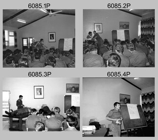 Bendigo Military Museum
Photograph - Army Survey Regiment - Regimental Training First Aid, 1985
This is a set of 14 photographs of Army Survey Regiment personnel undertaking the First Aid phase of regimental training held at Fortuna, Bendigo c1985. This was one of six objectives outlined in the administrative instruction – Exercise “City Soldier” accompanying these photos. The other objectives were weapons skills revision for SLR Rifle and M30 Grenade at Fortuna; RATEL and navigation at Wellsford Forest; and rifle shooting at Wellsford Rifle Range. Personnel from Air Survey, Cartographic, Lithographic and Headquarters Squadrons were reallocated to four training platoons for one week from 7th to 11th October 1985.This is a set of 14 photographs of the Army Survey Regiment undertaking first aid training, part of Regimental Training at Fortuna Villa, Bendigo. 1985. .1P to .8P are printed on photographic paper and scanned at 300 dpi. Photos .9P to .14P are on 35mm negative film and scanned at 96 dpi. They are part of the Army Survey Regiment’s Collection. .1) - Photo, black & white, 1985, L to R: WO1 Dick Manley – instructor, CPL Paul Davis. .2) - Photo, black & white, 1985, L to R: CPL Paul Davis, WO1 Dick Manley – instructor. .3) - Photo, black & white, 1985, L to R: WO2 Bill Kemp, – instructor, unidentified personnel. .4) - Photo, black & white, 1985, WO2 Bill Kemp, – instructor. .5) - Photo, black & white, 1985, L to R: CPL Dave Murphy, LT Carol Dunstan – instructor. .6) - Photo, black & white, 1985, L to R: SPR Wally Twidale, unidentified personnel. .7) - Photo, black & white, 1985, L to R: LT Carol Dunstan – instructor, SPR Viv (Hawkins) Doherty. .8) - Photo, black & white, 1985, unidentified WO2. .9) - Photo, black & white, 1985, L to R: WO1 Dick Manley – instructor, unidentified, LT Carol Dunstan – instructor. .10) - Photo, black & white, 1985, L to R: CPL Ken Peters, unidentified, SPR Viv (Hawkins) Doherty, unidentified (x3), LT Carol Dunstan – instructor in foreground, CPL Mick Minchin. .11) & .12) - Photo, black & white, 1985, WO2 Dave Miles with fake injured leg. .13) & .14) - Photo, black & white, 1985, unidentified officer– instructor, SPR Lorraine (Daly) Talbot-Smith..1P to .14P No personnel are identifiedroyal australian survey corps, rasvy, army survey regiment, army svy regt, fortuna, asr -
Bendigo Historical Society Inc.
Map - FRED COWIE COLLECTION: AERIAL MAPS OF HEATHCOTE/EPPALOCK, 28-9-60
Map, Heathcote C3, Aerial Survey of Victoria, Photo-map prepared by Department of Crown Lands and Survey from photographs taken in 1960.Copied photographically at the Central Plan Office. Date 28-9 60, C.P.O.Neg. No.21588.Campaspe River, Coliban River. Flower Hill. Fred Cowie,46 McIvor Rd.Bendigo (Not located 29.9.2022)Central Plan Office.map -
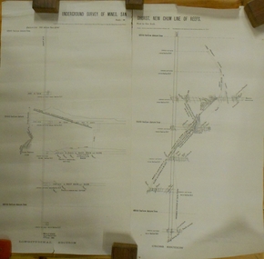 Bendigo Historical Society Inc.
Plan - MARKS COLLECTION: UNDERGROUND SURVEY OF MINES SANDHURST NEW CHUM LINE OF REEF
Plan, divided into two sheets, on top of sheet Underground survey of mines Sandhurst, New Chum Line of Reef. Surveyed by Caleb Thomas under the direction of Charles W. Langtree, Acting Secretary for Mines and Water Supply and Acting Chief Mining Surveyor for the Colony of Victoria. Drawn by Arthur Everett, Mining Department, Melbourne, 1884.bendigo, mining, new chum line of reef