Showing 13112 items matching "r-davis"
-
 Eltham District Historical Society Inc
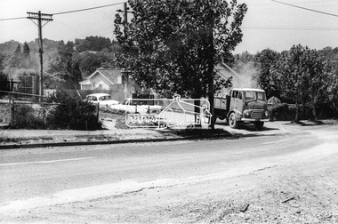
Photograph, Looking southeast from Main Road at intersection with Brougham Street, c. September 1966, 1966c
View looking across the front grounds of the former Police Station towards the weatherboard building on the opposite corner of Brougham Street which was once used as a Doctor's surgery by Dr R. Bradbury in the 1930s. The property was known as Cooinda. The Bradbury family also owned the houses adjacent to Napoleon Street. Succeeding Dr Bradbury was Dr R.B. Loosli, resident from 1947 to 1961. The house was later developed into a series of restaurants, Marcella's in the 1980s/1990s, Gennaro's Pizza Restaurant 2010s, Franco Pizza, presently being Franco and Co.Black and white photographic printOriginally located in a Filmpro King Size Prints processing envelope $3.01 Shire of Eltham 9/9/66 and noted as Calrossie Ave area and crossed out Eltham-Yarra Glen Road, Bridge Street to Elsa Court existing conditions mid 1967brougham steet, franco and co, local history centre, main road, restaurants, road construction, streets, cooinda -
 Ballarat Clarendon College
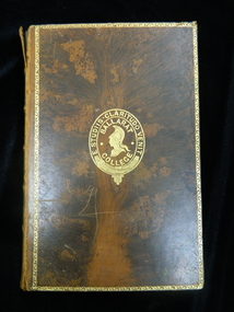
Book prize, The fifteen decisive battles of the world: from Marathon to Waterloo
Lloyd Charles Brind, born 7/09/1882, entered Ballarat College 6/02/1893. This book was donated back to the school by Mr McCallum, July 1964 and added to the Ballarat College Library. This may be Mr R A McCallum, parent of school during the 1960s and father of Keith (1964), Stuart (1967) and Peter (1974). At some stage it has been stamped with the Tam O'Shanter Ballarat Book Club stamp. It also has a handwritten signature on the title page and half-title page 'N. V. Warol" ?Marled brown calf-bound book with gold border and school crest on front cover, six compartments to spine with gold patterning to five and title in 2nd compartment; book plates inside front coverBook plate inside front cover: school crest / Languages / Fourth form / Second prize / Awarded to / L Brind / Christmas 1896lloyd-charles-brind, book prizes, mccallum -
 Eltham District Historical Society Inc
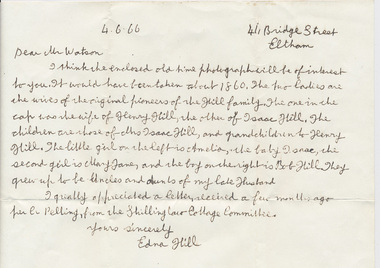
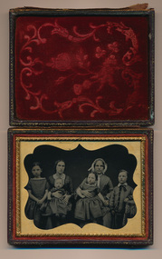
Photograph, Members of the Hill family, early Eltham settlers, c.1860, 1860c
Mrs Henry Hill (in cap) with Mrs Isaac Hill and her children, L-R: Amelia Hill, Mrs Isaac Hill with baby Isaac on her lap, Mary Jane Hill seated on Mrs Henry Hill's lap and Bob Hill. Photo enclosed in a leather bound clam shell box with felt lining and gold trim. Donated by Mrs Ivy Edna Hill, 4/1 Bridge Street, Eltham, 4 June 1966 and includes copy of her note identifying the people. Early pioneer settlers of ElthamPhotograph mounted in a gold frame with glass encased in a small clam-shell box lined with padded red felt and with catchamelia hill, bob hill, early settlers, eltham, hill family, isaac hill, mary jane hill, mrs henry hill, mrs isaac hill -
 Eltham District Historical Society Inc
Photograph, Members of the Hill family, early Eltham settlers, c.1860, 1860c
Mrs Henry Hill (in cap) with Mrs Isaac Hill and her children, L-R: Amelia Hill, Mrs Isaac Hill with baby Isaac on her lap, Mary Jane Hill seated on Mrs Henry Hill's lap and Bob Hill. Photo enclosed in a leather bound clam shell box with felt lining and gold trim. Donated by Mrs Ivy Edna Hill, 4/1 Bridge Street, Eltham, 4 June 1966 and includes copy of her note identifying the people. Early pioneer settlers of ElthamPhotograph mounted in a gold frame with glass encased in a small clam-shell box lined with padded red felt and with catchamelia hill, bob hill, early settlers, eltham, hill family, isaac hill, mary jane hill, mrs henry hill, mrs isaac hill -
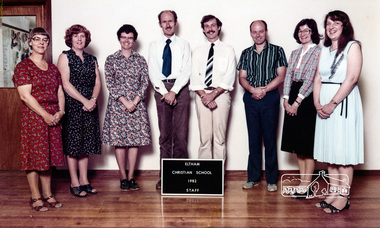 Eltham District Historical Society Inc
Photograph, Eltham Christian School, staff, 1982, 1982
L-R: Adelaide Wilson (Teacher’s Aide), Chris Field (Craft), Helen Hillas (Primary Teacher), Chris Trinham (Pastor and Bible Studies), Gavin Phillips (Secondary Teacher), Alan Field (Electives), Anne Wilson (Secretary), Glenda Watts (Typing) From an album featuring a series of photographs (some cropped) from a magnetic photo album relating to the staff, students and activities of the Eltham Christian School which operated as part of the Eltham Christian Church at Nyora Road, Eltham. See also entries for each photograph.colour photographeltham christian school, nyora road, adelaide wilson, chris field, helen hillas, chris trinham, gavin phillips, alan field, anne wilson, glenda watts -
 Eltham District Historical Society Inc
Photograph, Peter Bassett-Smith, Unveiling ceremony of the Memorial Plaque at corner of Main Road and Pitt Street, Eltham commemorating the 20th Anniversary of Eltham District Historical Society, 10 October 1987, 10/10/1987
L-R: Mrs Beryl Read, Mrs Kath Stephenson (immediate past President, Shire of Eltham Historical Society), Mrs Marjorie Smith Motschall, guests at the event to unveil the plaque for the time capsule. The commemorative plaque explains the functions of the various items used in the Victorian 150th Anniversary Monument and Time capsule. Marjorie Smith Motshcall (1911 -2001) was a member of EDHS and the recorder of Panton Hill's history, and wrote on a number of historical subjects, including the chapter "The Pioneer Woman" in "Pioneers and Painters". (NL 138)Colour photograph1987, activities, eltham community centre, time capsule -
 Federation University Historical Collection
Document, Walter Martin of Garibaldi, Victoria, c2015
Walter Martin was born on 25 August 1915, and died on 07 October 1995. He was raised on the family property of Garibaldi which was opposite the Garibaldi Bridge, and attended the Garibaldi State School until 1930. At the time of Walter Martin's retirement the family property had been in the family for 130 years. He was a keen photographer and combined this passion with a knowledge of the history of Garibaldi and Durham Lead. Walter Martin was an engineering blacksmith at Durham Lead and lived at 'Cragleigh' RSD R-885, Durham Lead, 3352.Nine typed pages relating to Walter Martin, including copies of photographs. It includes a copy of a reference from the Buninyong Shire Council.walter martin, blacksmith, garibaldi, durham lead, elaine, garibaldi bridge -
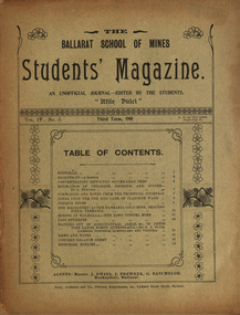 Federation University Historical Collection
Booklet, Ballarat School of Mines, Student Magazine, Third Term, 1901, 1901
Articles include: Concentrating difficult silver-lead ores, Estimation of chlorine, bromine and iodine (by D.Runting. Summaries and notes from the technical journals, Notes upon the use and care of platinum ware, Common sense, The machinery at the Tasmania gold mine, Beacons-Field, Tasmanina, Mining at Walhalla - The long tunnel mine, Past students, Mapping out of agricultural areas &c., in dense vine lands, North Queensland (by R. A. Suter. Licensed surveyor, Queensland and Victoria), News and notes, Concert balance sheet, Editorial notices.Soft covered magazine of 16 pages. silver-lead ores, estimation of chlorine, bromine and iodine (by d.runting), platinum ware, tasmania gold mine, beaconsfield, tasmania, mining at walhalla, long tunnel mine, vine lands, north queensland, r. a. suter, photography class, boer war, alumni, thomas vincent, basil sawyer, o. e. jager, a. s. burdekin, t. phillipson, glen macpherson, tom uthwatt, marcus marks, r. j. allen, cecil eales, cecil wakley, adam morton, e.p. lewers, harry leggo, jack hill, berk, nickolls, h. burrows, percy osborne, j. brangan, chris evans, adamson, alford, r. evans, arthur "thomas" atkins, charles campbell, hardy, a. basil reid, h. l. krause, k. grant, m. gray, a.b. reid, h. alston, playford, j. a. reid, s. b. vial, f. a. marriott, f. lush, c. whyte, karl moore, r. robin, w. j. lakeland, e. trend, h. l. giles, r. mccracken, k. bryron moore -
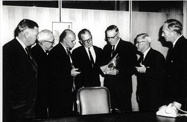 Port Melbourne Historical & Preservation Society
Photograph - City of Port Melbourne Councillors & staff meeting with PMG representative at presentation of Subscriber Truck Dialing (STD), C. 1960s
City of Port Melbourne Councillors & staff with a PMG official presenting the new concept of Subscriber Trunk Dialling. (STD). L - R Garnet WILLIAMS (Engineer), Andy AANENSEN (Town Clerk), Cr Cyril LETTS, Cr Ray JULIER, ? PMG official, Cr Les TURNER, Jack ANDERSON (Electrical Engineer). Probably taken in the mid to late 1960s. Andy Aanensen was Town Clerk 1959-1968 and Cyril Letts served on Council 15 May 1954 until he resigned on 24 Sep 1968.B & W photograph of City of Port Melbourne Councillors & staff receiving a presentation from a PMG official. Names on the reverse of photo are listed right to left.engineering department - city of port melbourne, port melbourne council, jack anderson, leslie stanley turner, ray julier, cyril letts, andreas (andy) t aanensen, garnet s williams -
 NMIT (Northern Melbourne Institute of TAFE)
Book: Piano technology: an introduction, Book: Piano technology: an introduction by Wayne Stuart 1993
Also held is copy of an article written by Margaret Harrison about the Wayne Stuart's construction of a Grand Piano, and reference to the construction in Music and the Teacher v18 no.3 September 1992. Also 4 photos of the grand piano being constructed. Photo A 'Sand cores being positioned to cast the largest piano frame made in Australia. L-R Charles Schaefer, Production Supervisor, T.Main & Sons, Wayne Stuart, Piano Maker, Werner Stephan, Manager, John Williams Patterns. (from Music and the Teacher 1992).Spiral bound book of 167 pages, ACMIT edition, First published 1993.ISBN 0646143131preston technical college, course book, piano technology course 1993, wayne stuart, nmit. -
 Stawell Historical Society Inc
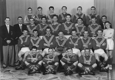
Photograph, Warriors Football Club Team 1956
Back Row : G Giles, J Hull, Reeves, F Lever, W Rickard, L Healy 2nd : K Pianta (Sec), L Blake (President), B Larkin, M Stewart, W Hall, R Overall, N Grainger, D Mc Master, J Hatcher (Selector), T Wallace (Boundary) 3rd : P Boag, S Boag, J Larkin, V Chapman, B Chapman, C Smith, B Boag 4th : C Chappell, G Cashin, P Ledger, T Bell.Football team seated and standing with drapes in background.Names on Backsport, football -
 Stawell Historical Society Inc
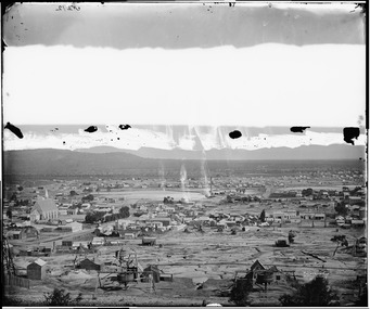
Photograph, View of Stawell from Big Hill April 1874 showing mines centered on St Georges Crushing Mill -- 5 Photos
From left Reefs Restaurant, T. Hogan & Co Tea Wine Spirits Merchant, R. Hepburn Carolina Hotel, Pleasant Creek Hotel, St George Stamping Battery, Free Methodist Chapel Church, Ballarat Hotel, Woodcock Produce Grocer, Stawell Brewery in far distance, L. Thomas Wheelwright Farrier & General Blacksmith, Australian Hotel, G. Laing Bootmaker, Brierly & Wilson Greengrocer, P. Corkeron Bootmaker, P. Corkeron Wholesale Retail General Grocer, Globe Hotel in distance, Christ Church.Part of Holtermann Collection. Black and White photograph of Stawell from Big Hill with mining in foreground. April 1874. View covers from St Patrick's Church to current location of Police Station along Patrick Street. St George Crushing Mill near Centre of Photograph. Includes Carolina Hotelmining, panorama -
 Hume City Civic Collection
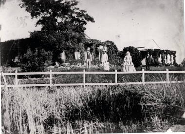
Photograph, Woodlands Homestead, c1858 - 59
The photograph is of the Woodland Homestead at Bulla which was sited along the Moonee Ponds Creek. William Pomroy Greene and his wife Anne, emigrated from Scotland and arrived in the Port Phillip area in December 1842.. He acquired the Crown land at Gellibrand Hill in 1843 and built the prefabricated homestead which became known as Woodlands. The people in the photograph, taken about 1859 - 60, are L- R: Possibly Sir Willian Stawell, ?, little Anne Catherine Greene at 2 years, Rawdon Greene, Mrs. Greene and Smith ( a butler).The Greene family were one of the early European settlers to acquire land in the Bulla Bulla district. The Woodlands property is now a national park and the significant Gellibrand Hill is within the park.A black and white photograph of 3 men, a lady and a child standing in a garden in front of a homestead. A wooden post and rail fence is in the foregroundwoodlands homestead, greene family -
 Ballarat Tramway Museum
Poster, State Electricity Commission of Victoria (SECV), "The New System of Fares and Sections to be Introduced on Sunday, 3rd October 1937", Sep. 1937
Poster titled "The New System of Fares and Sections to be Introduced on Sunday, 3rd October 1937" produced by the SECV, Ballarat Electric Tramways. r. Provides information on the SEC control, the method of payment, sections, fares, weekly, school, scholars, luggage and parcel, View Point Services and Tourist Ticket. Signed by H. N. Hornabrook as Manager. Has printer's name, Tulloch and King in the bottom left-hand corner. See Reg. Item 8025 for individual copies and 8251 for the associated map/fare poster that was used in tramcars.Demonstrates the work the SEC undertook to provide information on the new ticket system of 1937 and yields information about the system.Poster contained within Reg. Item 2488, page 30, Numerous on page 31 in ink and penciltrams, tramways, sec, fares, sections, tickets -
 Kew Historical Society Inc
Photograph - Brick and Stucco Bungalow, J E Barnes, c.1920
The Kew Historical Society's map collection includes a substantial number of real estate subdivision plans, mainly of Kew but also of surrounding suburbs in Melbourne. Most of the subdivision plans date from the 1920s and 1930s when the districts old homes and local farmland were being split up to accommodate residential growth in the postwar period. These early plans were assembled by a local firm, Jas R Mather & McMillan, which had an office in Cotham Road. Many of the plans, and sometimes photos, were annotated by the agents.Subdivision plans are historically important documents used as evidence for the growth of suburbs in Australia. They frequently provide information about when the land was sold as well as evidence relating to surveyors and real estate and financial agents. The numerous subdivision plans in the Kew Historical Society's collection represent working documents, ranging from the initial sketches made in planning a subdivision to printed plans on which auctioneers or agents listed the prices for which individual lots were sold. In a number of cases, the reverse of a subdivision plan in the collection includes a photograph of a house that was also for sale by the agent. These photographs provide significant heritage information relating house design and decoration, fencing and household gardens.The photograph may also be aesthetically significant depending o the importance of the photographic atelier.Real estate photograph for a local agent by the Kew photographer, Josiah Earl Barnes. The photo is of a weatherboard or brick rendered bungalow with a twisted wire fence. Given Barnes' status a a Kew photographer, the house is probably locate din Kew or East Kew. Unfortunately the handwritten information on the mount bordering the photo is damaged and cannot be read. The bungalow has a gabled, tiled roof with terra cotta finials at the front of both gables. The house has a central doorway, framed by a pseudo portico supported by four wooden columns. On each side of the doorway, at the front, there are paired sash windows, which, like the half-timbered gable, are picked out in a darker colour.Handwritten, mostly illegible description by selling agent on mount surround: " .... in Diningroom, Drawing Rooms, ... Photographers details printed on mount: "J. E. Barnes / Photo / Phone 1966 Haw KEW"houses - kew, bungalows - kew, real estate photographs, j.e. barnes -- photographer -
 Kew Historical Society Inc
Photograph - Victorian Double-fronted Brock Villa, Cotham Road, c. 1919
The Kew Historical Society's map collection includes a substantial number of real estate subdivision plans, mainly of Kew but also of surrounding suburbs in Melbourne. Most of the subdivision plans date from the 1920s and 1930s when the districts old homes and local farmland were being split up to accommodate residential growth in the postwar period. These early plans were assembled by a local firm, Jas R Mather & McMillan, which had an office in Cotham Road. Many of the plans, and sometimes photos, were annotated by the agents.Subdivision plans are historically important documents used as evidence for the growth of suburbs in Australia. They frequently provide information about when the land was sold as well as evidence relating to surveyors and real estate and financial agents. The numerous subdivision plans in the Kew Historical Society's collection represent working documents, ranging from the initial sketches made in planning a subdivision to printed plans on which auctioneers or agents listed the prices for which individual lots were sold. In a number of cases, the reverse of a subdivision plan in the collection includes a photograph of a house that was also for sale by the agent. These photographs provide significant heritage information relating house design and decoration, fencing and household gardens.The photograph may also be aesthetically significant depending o the importance of the photographic atelier.Real estate photographs of a classic double-fronted late Victorian brick villa. It central location in Cotham Road, Kew enabled the selling agent to note its proximity to the tram. With seven rooms, all ‘modern conveniences’, and land of 66×167, the house was to be sold for £1100. The villa has a number of interesting features including a pattern within the slate roof as well as the use of polychrome brickwork under the eaves and on the façade. The intricacy of the cast iron lace is emphasised by the line of projecting wooden blocks above it. The picket gate is painted a different colour to the pickets of the fence. The house has a name (illegible) that is attached to the inset cast iron lace of the central projecting gable in the veranda. Stamped on mount: "Kew. Central. Close tram. / Comfortable Brick Villa. / Containing 7 rooms / Modern conveniences: / Land 66 x 167. Sold 1100 pounds:"houses - kew, victorian villas, real estate photographs, cotham road - kew -
 Kew Historical Society Inc
Photograph - Double-fronted Edwardian Villa, c.1918
The Kew Historical Society's map collection includes a substantial number of real estate subdivision plans, mainly of Kew but also of surrounding suburbs in Melbourne. Most of the subdivision plans date from the 1920s and 1930s when the districts old homes and local farmland were being split up to accommodate residential growth in the postwar period. These early plans were assembled by a local firm, Jas R Mather & McMillan, which had an office in Cotham Road. Many of the plans, and sometimes photos, were annotated by the agents.Subdivision plans are historically important documents used as evidence for the growth of suburbs in Australia. They frequently provide information about when the land was sold as well as evidence relating to surveyors and real estate and financial agents. The numerous subdivision plans in the Kew Historical Society's collection represent working documents, ranging from the initial sketches made in planning a subdivision to printed plans on which auctioneers or agents listed the prices for which individual lots were sold. In a number of cases, the reverse of a subdivision plan in the collection includes a photograph of a house that was also for sale by the agent. These photographs provide significant heritage information relating house design and decoration, fencing and household gardens.The photograph may also be aesthetically significant depending on the importance of the photographic atelier.On the reverse of a subdivision plan of the Palmyra Estate (Kew) is a photograph of a double-fronted Edwardian villa. The weatherboard and stucco house with high brick chimneys provides a clear indication of the style of curtains and gardens in houses of the period. Holland blinds with lace inserts are used in the left front window. They are combined with long lace curtains. The garden, with its curved pathway is bordered with garden beds that include marguerite daisies and roses. Reflecting a new interest in the Australian landscape, tree ferns and ground ferns are planted closer to the house.houses - kew, architecture - edwardian, real estate photographs -
 Kew Historical Society Inc
Photograph - Cottage, probably East Kew, A. Aberline, 1920s
The Kew Historical Society's map collection includes a substantial number of real estate subdivision plans, mainly of Kew but also of surrounding suburbs in Melbourne. Most of the subdivision plans date from the 1920s and 1930s when the districts old homes and local farmland were being split up to accommodate residential growth in the postwar period. These early plans were assembled by a local firm, Jas R Mather & McMillan, which had an office in Cotham Road. Many of the plans, and sometimes photos, were annotated by the agents.Subdivision plans are historically important documents used as evidence for the growth of suburbs in Australia. They frequently provide information about when the land was sold as well as evidence relating to surveyors and real estate and financial agents. The numerous subdivision plans in the Kew Historical Society's collection represent working documents, ranging from the initial sketches made in planning a subdivision to printed plans on which auctioneers or agents listed the prices for which individual lots were sold. In a number of cases, the reverse of a subdivision plan in the collection includes a photograph of a house that was also for sale by the agent. These photographs provide significant heritage information relating house design and decoration, fencing and household gardens.The photograph may also be aesthetically significant depending on the importance of the photographic atelier.An elevated, modest weatherboard house, photographed towards the end of the construction phase. The lower section of the weatherboards are exposed and stained. The upper section is rendered with rough-cast. The tiled roof has a single gable that extends over the centrally placed front porch. On the porch, the door and single sidelight are filled with coloured leadlight whereas the casement windows in the front rooms contain plain glass. The leadlight and the wrought iron of the verandah are the only decorative elements of the utilitarian design. The location of the house, which was advertised for sale, has not to date been identified. The real estate photograph is mounted on the reverse of a subdivision plan for the Harvest Home Estate, Kew East.Photographer's stamp, lower right on mount: "A. Aberline, Glenferrie"houses - kew, bungalows - kew, real estate photographs -
 Kew Historical Society Inc
Photograph - Bungalow, probably East Kew, 1920s
The Kew Historical Society's map collection includes a substantial number of real estate subdivision plans, mainly of Kew but also of surrounding suburbs in Melbourne. Most of the subdivision plans date from the 1920s and 1930s when the districts old homes and local farmland were being split up to accommodate residential growth in the postwar period. These early plans were assembled by a local firm, Jas R Mather & McMillan, which had an office in Cotham Road. Many of the plans, and sometimes photos, were annotated by the agents.Subdivision plans are historically important documents used as evidence for the growth of suburbs in Australia. They frequently provide information about when the land was sold as well as evidence relating to surveyors and real estate and financial agents. The numerous subdivision plans in the Kew Historical Society's collection represent working documents, ranging from the initial sketches made in planning a subdivision to printed plans on which auctioneers or agents listed the prices for which individual lots were sold. In a number of cases, the reverse of a subdivision plan in the collection includes a photograph of a house that was also for sale by the agent. These photographs provide significant heritage information relating house design and decoration, fencing and household gardens.The photograph may also be aesthetically significant depending on the importance of the photographic atelier.An unusual bungalow that does not conform to a particular architectural style but which contains eclectic elements of the style of varying periods. The most striking element of the design is the cantilevered veranda that is supported by heavy chains that are attached to the central gable. This deep gable extends across most of the façade, forming an extensive veranda. Parts of this are infilled with screens. Seven wooden posts, whose lower halves are encased in rendered brick pillars, support this gabled veranda. The roof would appear to be covered with corrugated iron. The location of the house, which was advertised for sale, has to date not been identified. The real estate photo is on the reverse of a plan for the Myrtle Hill Subdivision, Kew.bungalows - kew, architecture - 1920s, real estate photographs -
 Kew Historical Society Inc
Plan - Subdivision Plan, Argyle Road, Heather Grove, Victor Avenue, Kew, c.1937
The Kew Historical Society's map collection includes a substantial number of real estate subdivision plans, mainly of Kew but also of surrounding suburbs in Melbourne. Most of the subdivision plans date from the 1920s and 1930s when the districts old homes and local farmland were being split up to accommodate residential growth in the postwar period. These early plans were assembled by a local firm, Jas R Mather & McMillan, which had an office in Cotham Road. Many of the plans, and sometimes photos, were annotated by the agents.Subdivision plans are historically important documents used as evidence for the growth of suburbs in Australia. They frequently provide information about when the land was sold as well as evidence relating to surveyors and real estate and financial agents. The numerous subdivision plans in the Kew Historical Society's collection represent working documents, ranging from the initial sketches made in planning a subdivision to printed plans on which auctioneers or agents listed the prices for which individual lots were sold. In a number of cases, the reverse of a subdivision plan in the collection includes a photograph of a house that was also for sale by the agent. These photographs provide significant heritage information relating house design and decoration, fencing and household gardens.The photograph may also be aesthetically significant depending on the importance of the photographic atelier.Undated blue subdivision plan in Kew of 14 lots facing Argyle Road, Heather Grove and Victor Road. The Plan identifies Tuxen & Miller as the surveyors. [Formerly catalogued as MAP.0059]subdivision plans - kew, argyle road - kew, heather grove - kew, victor avenue - kew -
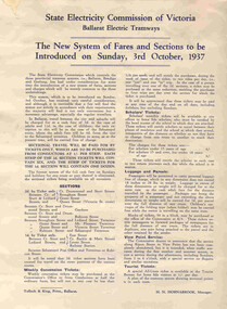
 8th/13th Victorian Mounted Rifles Regimental Collection
Licence
Geoffrey R Fink volunteered for military service in early 1940. He served initially with 3rd Division A.A.S.C. but was discharged as being in a reserved occupation at the Aircraft Production Commission. He resigned from the Commission and joined the AIF on 28 July 1941 and was allotted to 2/8th Armoured Regiment. He served with the regiment in New Guinea and on return to Australia was transferred to No 41 Landing Craft Company serving out the war in the South Pacific. Geoffrey Fink died 14 March 2008 aged 86 at Wangaratta Victoria.Complements other objects in the collection relating to this WWII soldier. Military Motor vehicle Drivers licence No. 34060 29 - 1 - 41325862 Corporal Fink - Geoffrey Roland 3 Division AASCfink geoffrey r mr, 2/8th armoured regiment, 41 landing craft company -
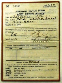
 The Beechworth Burke Museum Research Collection
Card (Series) - Index Card, George Tibbits, 11 William Street, Beechworth, 1976
George Tibbits, University of Melbourne. Faculty of Architecture, Building and Town & Regional PlanningIndex system that support the research for Beechworth : historical reconstruction / [by] George Tibbits ... [et al]Arranged by street names of BeechworthEach index card includes: street name and number of property, image of property, allotment and section number, property owners and dates of ownership, description of the property according to rate records, property floor plan with dimensions.beechworth, george tibbitsbeechworth, george tibbits -
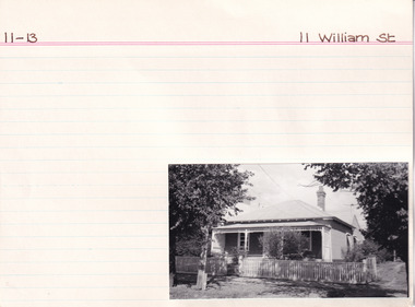
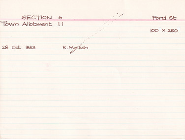
 The Beechworth Burke Museum Research Collection
Card (Series) - Index Card, George Tibbits, 12 Ford Street, Beechworth, 1976
George Tibbits, University of Melbourne. Faculty of Architecture, Building and Town & Regional PlanningIndex system that support the research for Beechworth : historical reconstruction / [by] George Tibbits ... [et al]Arranged by street names of BeechworthEach index card includes: street name and number of property, image of property, allotment and section number, property owners and dates of ownership, description of the property according to rate records, property floor plan with dimensions.beechworth, george tibbitsbeechworth, george tibbits -
 The Beechworth Burke Museum Research Collection
Card (Series) - Index Card, George Tibbits, Ford Street, Beechworth, 1976
George Tibbits, University of Melbourne. Faculty of Architecture, Building and Town & Regional PlanningIndex system that support the research for Beechworth : historical reconstruction / [by] George Tibbits ... [et al]Arranged by street names of BeechworthEach index card includes: street name and number of property, image of property, allotment and section number, property owners and dates of ownership, description of the property according to rate records, property floor plan with dimensions.beechworth, george tibbitsbeechworth, george tibbits -
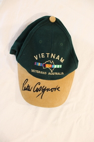 National Vietnam Veterans Museum (NVVM)
Souvenir - Cap, peaked
This item was collected because it has been signed by Sir Peter Cosgrove MC, Patron on the National Vietnam Veterans Museum. He served as a Lieutenant in Vietnam :1 Australian Reinforcement Unit 02 Aug 1969 -19 Aug 1969, 9th Battalion, The Royal Australian Regiment 20 Aug 1969 -28 Sep 1969,Headquarters, 1st Australian Task Force 29 Sep 1969 - 30 Jul 1970. It was donated by National Serviceman R V Williams, a private who served under Lieutenant Cosgrove.Bottle green peaked cap with a tan brim. Embroidered. Signed in black felt pen by Peter Cosgrove.Vietnam/ Map of Australia/Vietnam 4 color bar crossing the map/ Vietnam Veterans Australia/ signature of Peter Cosgrove.souvenir, vietnam veterans cap, sir peter cosgrove signature, cosgrove, williams, r v williams -
 Bacchus Marsh & District Historical Society
Map, Allotments in the Village of Rowsley, Parish of Gorrocburkghap, County of Grant c.1856
Rowsley is a locality 11 kilometers south-west of Bacchus Marsh. The date of this map is uncertain. A very similar map held by the State Library of Victoria (SLV) contains slightly more information than this copy and is dated as an 1856 map. SLV reference: 'Allotments in the Village of Rowsley, Parish of Gorrocburkghap, County of Grant', by T. Nixon, Assistant Surveyor, May 1856 ; Surveyor General’s Office, July 18 1856 (lithographed by R. Meikle). (1856). Melbourne: Surveyor General’s Office. MAPS 820 BJE 1837- ROWSLEY 1856. A single page paper map. A cadastral map of the Village of Rowsley in Victoria, showing numbered land allotments. 57 allotments are shown on the map and some areas set aside as reserves. Allotments 8, and 10-16 are outlined in red ink and allotment 9 has a cross in red ink on it. The map is pasted into a bound volume containing 76 maps or plans in total. High resolution digital image stored on BMDHS computer network. rowsley victoria history, rowsley victoria maps -
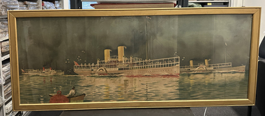 Port Melbourne Historical & Preservation Society
Poster - PS Weeroona, PS Hygeia and PS Ozone, Deane Taylor, c 1912
Appears to be a trimmed version of an advertising poster for the bay steamers, Weeroona, Hygeia and Ozone. The original poster has a brown border with 'Health and Pleasure Trips on Port Phillip Bay' above the picture and 'by the "Weeroona" "Hygeia" and "Ozone"' below the picture. The border and some of the picture, including the artist's signature, have been removed to create this item. The Nepean Historical Society Inc. hold an intact version of the advertising poster. The full version of the image was also used for a postcard by B R Gowan & Co held by the State Library of Victoria.Large unsigned, framed poster of PS Weeroona, PS Hygeia and PS Ozone formerly owned by Captain Harry GRAY. Glass fronted.piers and wharves - station pier, transport - shipping, arts and entertainment - visual arts, captain george henry (harry) gray, ps weeroona, ps hygeia, ps ozone, bay cruisers -
Glen Eira Historical Society
Document - TOURS
There are two copies of the Discover Caulfield guide produced by the Caulfield Historical Society. One from 1982 which contains twelve pages, seven of which are typed and the last five a continuation of the guide added later, hand-written. The other is a modern typed version of the same document, including information at the end that "Notes prepared by R. Ballantyne, 25th July, 1982, updated by Betty Snowball, 1992 and Gladys Vallati 4th August, 1995". They both detail a pictorial tours of the mansions and gardens in the City of Caulfield, similar but not identical.caulfield, mansions, gardens, homes, ‘lirrewa’, lirrewa grove, caulfield city hall, smith sydney, ‘halstead’, bambra road, halstead road, caulfield historical society, messrs. upton and smith, civic establishments, dickson james dr., houses, national trust, st. stephen’s church, balaclava road, gothic (revival) architecture, messrs. haddon and henderson, st. aloysius, archbishop of melbourne mannix dr., caulfield park, hawthorn road, inkerman road, kambrook road, paddy’s swamp, cannizzo philip, caulfield city council, trams, orrong road, grimwade house, ‘harleston’, grimwade frederick sheppard, primary schools, caulfield art centre, ‘stanmark’, art galleries, ‘craigellachie’, person william, pearson eliza, francis newton mr., greenmeadows gardens, milburn grove, greenmeadows house, lempriere john, mayors, ‘glenfern’, boyd john captain, boyd martin, ‘myoora’, alma road, ‘bagatelle’, christian thomas, henderson anketell, flats, building construction, ‘burreel’, kooyong road, burreel avenue, francis john, stephen sidney, allan george l., ‘royston’, renwick s. mrs., sargood frederick sir., ‘glen eira’, ricketson henry, caulfield hospital, royal southern memorial hospital, caulfield general medical centre, ‘ripponlea’, reed and barnes, architects, towers, rippon emma, rippon thomas, guilfoyle william, employees, ‘the village houses’, regent street, st. george’s road, cottages, bent thomas sir., jones louisa mrs., nathan benjamin, ‘anselm’, glenferrie street, queen anne style, haddon robert, historical buildings, princes’ park, ‘glenmore’, watts thomas, more hugh, glenhuntly road, gates, villas, ‘hopetoun’, hopetoun street, webb charles, hopetoun hospital, harleston park, allison street, langdon montague, langdon harry joseph, ‘tarqua’, ‘labassa’, manor grove, koch john, robertson a. w., wagner john, ‘ontario’, trinity congregational church, grange road, glen huntly, churches, greek orthodox church, ‘fairfield hall’, north road, younger james, glenhuntly post office, smith alfred, smith anne, methodist church, ‘lambros the cobbler’, railways, ballantyne r., snowball betty, kahlyn private hospital, ‘kynaston’, st. mary’s jubilee school, festivals and celebrations, st. mary’s anglican church, church of england, bishop moorhouse, joynt donoman, elsternwick post office, elsternwick, elsternwick bowling club, elsternwick rsl, caulfield grammar school, davis henry rev., selwyn street, elsternwick railway station, glen eira road, barnett r. j. rev., tudor court, world war 1914-1918, ‘fairhaven’, hope george, caulfield library, plaques, cannons, ‘janvec joinery’, parkside street, ‘parkside court’, clarence street, ‘streetscene’, grange road, greenhouses, vallati gladys -
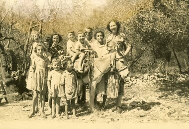 Ithacan Historical Society
Photograph - Rousso the Donkey, 1952
Donkeys were a standard form of transport and a beast of burden for Ithacans as the island is very mountainous. Stepped tracks designed for donkeys to ascend the mountains can be still be located. The donkey in the photo, 'Rousso' was owned by Achileas Benias and was used to transport the olives and produce form their farming plot. Photographed from L-R back are: Freda Lucas (nee Benia) holding Jenny Kyriakakis, Con and Demetri Vlass on the donkey, Georgos Sombola, Angeliki Lekatsa (Spiliatsos), and Annie Vlass. In the front are Georgia Benia, Michali Kavadeas, unknown.Annie Vlass together with her husband Stathi Vlass and children Demetri and Con spent 6-9 months in Greece in 1952 at the Vlassopoulos (Kopela) family home in Lahos whilst in Ithaca. Although not common prior to the 1960s, some Ithacans, who had settled in Australia prior to the post war era, did travel back to their homeland to visit family and to introduce spouses and children to their place of birth. Today many of Ithacan heritage travel to the island, particularly during the northern summer, to reconnect with their family roots.A sepia photograph of eleven people, eight children and three adults standing in a cleared wooded area around a donkey. Two of the children are on the back of the donkey.kopella -
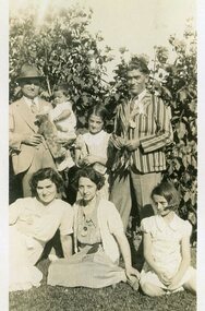 Ithacan Historical Society
Photograph, Kallinikos picnic group, c. 1930's
Photo taken at Ithacan picnic as denoted by shield shaped badges worn by some of the group. Photographed: L-R back: Spiros D. Kallinikos holding baby Jack Collins (Kallinikos), Cassie Kallinikos (later Connell) and Kosta (Con) Kallinikos; front Chrisoula Sikiotis (nee Kallinikos), Evriklia Kallinikos (nee Kolaitou married to Sprios D. Kallinikos) and Nina Kallinikos (later Black - married to Nick Black). Spiros, Chrisoula and Kosta are siblings as are their nieces and nephew Nina, Cassie and Jack (the children of Maria and Spiros Kallinikos). Ithacan picnics have always been extremely popular and well attended. They were and continue to be an important event in the yearly social calendar of the Ithacan Society. Today, with an increasingly dispersed and diverse membership, the annual picnic is the ideal opportunity for young and old to gather and reconnectBlack & white family photo of two ladies, two men and three children in a garden setting.