Showing 2349 items matching " mountains"
-
 Montmorency–Eltham RSL Sub Branch
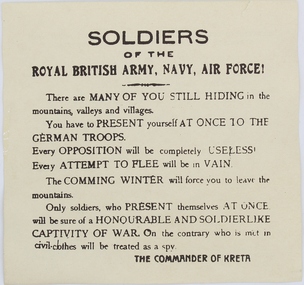
Pamphlet - German Propaganda Leaflet dropped on Crete, May 1941, World War 2. 1941
Leaflet dropped from German aircraft on to troops of the Royal army in Crete in May - June 1941 The propaganda leaflets were designed to lower moral of defending troops.Printed LeafletPrinted on leaflet “Soldiers of the ROYAL BRITISH ARMY, NAVY, AIR FORCE! There are MANY OF YOU STILL HIDING in the mountains, valleys and villages. You have to PRESENT yourself AT ONCE TO THE GERMAN TROOPS. Every opposition will be completely USELESS. Every ATTEMPT TO FLEE will be in vain. The COMING WINTER will force you to leave the mountains. Only soldiers, who present themselves AT ONCE will be sure of a HONOURABLE AND SOLDIERLIKE CAPTIVITY OF WAR. On the cntrary who is met in civil-clothes will be treated as a spy. THE COMMANDER OF CRETE On the reverse side of the leaflet is writing in the Greek language and also writing in English indicating that the leaflet was issued by the “GERMAN HIGH COMMAND OF CRETE”, MAY - JUNE 1941world war two, leaflet, propaganda, air drop -
 Marysville & District Historical Society
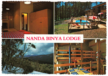
Postcard (item) - Colour postcard, NANDA BINYA LODGE, Unknown
A colour postcard from Nanda Binya Lodge in Marysville that was produced as a souvenir of Marysville.A colour postcard from Nanda Binya Lodge in Marysville that was produced as a souvenir of Marysville.NANDA BINYA LODGE,/ WOODS POINT RD.,/ MARYSVILLE, VIC. 3779./ 'Phone (059) 633433/ A lovely bush setting in the mountains only/ a 10 minute drive from Lake Mountain/ Alpine Reserve. New modern architect designed/ Scandinavian style Lodge./ -Sauna/ -Pool (HOT SPA TUB/ -B.Y.O. Restaurant/ -Nordic Ski, Toboggan, Bicycle and/ Fishing Gear hire./ -Large, well designed units, with private/ facilities for a top standard holiday/ -summer or winter at reasonable rates/ -relax Scandinavian at Nanda Binya. Single booking or groups of up to 30 *Special Activities include - ski/ movies, discos, nightime nordic skiing. W484M Stampmarysville, victoria, australia, nanda binya lodge, accommodation, postcard -
 Kiewa Valley Historical Society
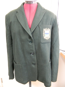
Mt Beauty High School Blazer
Mt Beauty High School commenced in 1953 as a Higher Elementary school as the need for a secondary college grew with the increase in population due to the Kiewa Hydro Electric Scheme. It became the Mt Beauty High School in 1964. The blazer was part of the winter uniform.Historical: Education in Mt Beauty commenced relatively late so there was less of a tradition The decision to adopt a uniform is of interest to compare with other schools and the times.Dark green blazer made from pure wool flannel. Size 38. with 3 green buttons down the front left side where the edge meets the right side (no overlap). ! pocket bottom right and bottom left sides. 1 on top left side. Top left pocket has coloured school emblem embossed on as part of the pocket. Long sleeves lined with white cotton. On inside of top pocket is make of blazer with 'J. Nelson' sewn on. inside middle back of collar a small label of maker.Outside left pocket: 'High School' above picture of mountains and river and below 'Mount Beauty.' Inside left pocket. Pinehurst / Blazer/ 'J. Nelson' sewn over (what might be Made by / Stamina / The "Doctor" pure Wool Flannel & tag 38. On middle inside at collar: Stamina / Productionuniform. school uniform. mt beauty. education. clothing. wool. mt beauty high school., blazer -
 Kew Historical Society Inc
Plan - Subdivision Plan, Camberwell Mountain View Estate, 1923
The Kew Historical Society collection includes almost 100 subdivision plans pertaining to suburbs of the City of Melbourne. Most of these are of Kew, Kew East or Studley Park, although a smaller number are plans of Camberwell, Deepdene, Balwyn and Hawthorn. It is believed that the majority of the plans were gifted to the Society by persons connected with the real estate firm - J. R. Mathers and McMillan, 136 Cotham Road, Kew. The Plans in the collection are rarely in pristine form, being working plans on which the agent would write notes and record lots sold and the prices of these. The subdivision plans are historically significant examples of the growth of urban Melbourne from the beginning of the 20th Century up until the 1980s. A number of the plans are double-sided and often include a photograph on the reverse. A number of the latter are by noted photographers such as J.E. Barnes.The so-called Camberwell Mountain View Estate was a subdivision on ‘the corner [of] Burke Road, Eyre and Wills Streets, Deepdene’. The Estate was not the first attempt to subdivide this land holding. In 1884, 1888 and 1894 the Belmore Park subdivision proposed 18 allotments for this parcel of land. The final stages of the Belmore Park subdivision occurred during the Depression of the 1890s. Apart from perhaps one block facing Burke Road, which is unnumbered in the Mountain View Estate subdivision, the rest must have remained unsold. The later subdivision would redraw the original 18 allotments, creating 22 new lots. In the Locality Plan on the left side of the subdivision plan, Deepdene Station, which formed part of the Outer Circle Railway is represented, as is the location of Deepdene Primary School. A selling point was the proposed extension of the Burke Road tram beyond its terminus at Cotham Road. The extension did not eventuate.subdivision plans - camberwell, mountain view estate -
 Orbost & District Historical Society
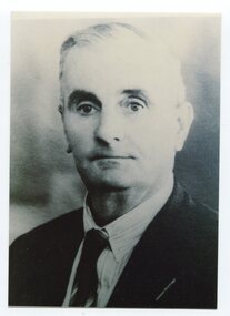
black and white photograph, C1947
This is a photograph of Councillor Henry Ingram who represented North Riding from 1927 - 1947 on the Orbost Shire Council. Harry Ingram delivered milk, bread, groceries and meat to towns between Delegate and Orbost with his eldest son. The pair generally drove a four wheeled wagon pulled by five horses along a hand carved winding track through the mountains.This item is associated with the Orbost Shire Council. The shire covered an area of 9,347 square kilometres and existed from 1892 until 1994 when it became part of the East Gippsland Shire Council.A black / white head and shoulders portrait photograph of a man in a suit.There is also a framed photograph.on back - " Cr H. Ingram J.P. , North Riding 1929-1947"ingram-henry orbost-shire-council -
 Ithacan Historical Society
Photograph, Honouring Loula Rodopoulos, 2015
IPS treasurer Eugenia Vlass-Tsalikis and president Anthony Drakopoulos together with Maria Johnson were guests at a function at MacRobertson Girls' High School, which was held in honour of Loula Rodopoulos (nee Raftopoulos). Loula was very active the community and was a board member of the Victorian Women's Trust. The mural behind the guests depicts some of the Greek myths of the sea, the woodlands, the mountains and the rivers. A coloured photograph of two ladies and a man standing in front of a large mural in a gallery. -
 Marysville & District Historical Society
Flyer (item) - Information Flyer, Forests Commission, Victoria, Cumberland Scenic Reserve, 1918-1983
An information flyer that was produced as a guide to the Cumberland Scenic Reserve by the Forests Commission of Victoria. The Forests Commission Victoria (FCV) was the main government authority responsible for management and protection of State forests in Victoria, Australia between 1918 and 1983. The Commission was responsible for ″forest policy, prevention and suppression of bushfires, issuing leases and licences, planting and thinning of forests, the development of plantations, reforestation, nurseries, forestry education, the development of commercial timber harvesting and marketing of produce, building and maintaining forest roads, provision of recreation facilities, protection of water, soils and wildlife, forest research and making recommendations on the acquisition or alienation of land for forest purposes″. The Cumberland Scenic Reserve is set in the heart of the mountain forests of Victoria and is 16km east of Marysville on the Cumberland Road. This reserve forms part of the catchment of Armstrong Creek, a tributary of the Yarra River which provides water for the Melbourne area. The reserve is a prime mountain ash area in which is set the old Cambarville sawmill and village site.An information flyer that was produced as a guide to the Cumberland Scenic Reserve by the Forests Commission of Victoria. 423Aforests commission victoria, cumberland scenic reserve, marysville, victoria, cambarville, the big tree, cora-lyn falls, barton's lookout, cumberland falls, sovereign view, armstrong creek, yarra river, mountain ash -
 Ringwood and District Historical Society
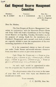
Pamphlet, East Ringwood Reserve Management Committee
An A5 flyer from the East Ringwood Reserve Management Committee in conjunction the Mountain District Horse and Pony Club announcing a Gymkhana at the East Ringwood Reserve on Cub Day, Tuesday November 1st for raising funds for the installation of a Children's Playground and second oval. Looking fo donations to cover or part cover the event. President: Mr. R. Guest. Treasurer: Mr F.S. Hardidge. Hon. Sec.: Mr C.C. Davis. -
 Bendigo Military Museum
Photograph - PHOTOGRAPHS, RABAUL
Series of photographs taken near Rabaul in 1941 during WW2, of the Volcano Matupi and other local scenes. Taken by Ern King who died on Rabaul. Collection of 9 photos of Rabaul 1941. All Black and white with white borders. 1. A blow hole at Matupi with smoke coming out. 2. Snow on side of mountain. 3. A stump on side of Matupi. 4. & 5.Photos of Albino camp with soldiers watching natives. 6. Photo of the Volcano at Matupi. 7. Photo on top of Volcano at Matupi. 8. Photo of natives climbing a coconut tree. 9. Photo of a crocodile.On the back of each is written the following; 1. A blow hole at Matupi. 2. Bed (?) of Matupi 1941. 3. A stump on side of Matupi. 4. & 5.Photos of Albino camp 1941. E.G. King 6. Matupi from the bottom 1941. 7.Near the top of Matupi. 8. Getting a few coconuts for use. 9. A snap of a crocodile.rabaul 1941, volcano, matupi, ww2, e. g. king -
 Marysville & District Historical Society
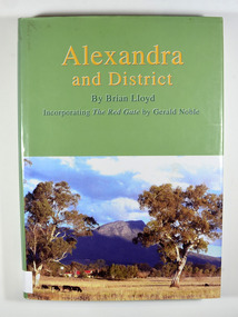
Book, Alexandra and District, 2006
A history of Alexandra and surroundsHardback. Front cover has a photograph of a farmhouse in a paddock with Cathedral Mountain in the background. Back cover has a circular emblem that has a miner digging, a pump house and poppet head and some bales of wool. The words 'Founded on gold wool and butter' surround the centre. There is also a photograph of the main street of old Alexandra with a stagecoach drawn by two horses that has three people seated in and on the stagecoach along with some luggage on the roof.Stamp of the Marysville & District Historical Society Inc / P.O. Box 22 / Marysville 3779alexandra region-victoria, history -
 Bendigo Military Museum
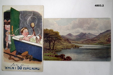
Postcard - A HUMOROUS CARD AND A SCENIC CARD, James Henderson & Sons Ltd London et al, c1910-1918
See Cat 4799 for data4803.1 - Humorous card - shows a soldier boy in a hot bath tub with a modest young girl passing some more soap on a plate. printed in colour. The title at the bottom is - "When I do come home!" "Sure thing" is hand written above the printed line. 4803.2 - Scenic Card - A coloured print showing a lane, cattle drinking and mountains in the background. Printed on the bottom is "Snowdon from Capel Curig."4803.1 - Rear has a message Mary Ling dated 25 Nov. He talks about Salisbury, Christmas leave. 4803.2 - Rear has a brief message to "Dear Susie.... (About Mail) Jo" Dated 21 Jan 1918ww!, sisters, wales, salisbury -
 Bendigo Military Museum
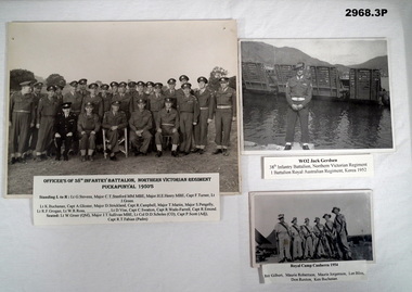
Photograph - PHOTOGRAPHS, 38TH POST WW2, 1) c.1950's; .2) 1952; .3) 1954
.1) Black & white group photo of the Officers of 38th Infantry Battalion in uniform. Officers are seated & standing with a number of trees in the background. Attached printed label includes the office's names. Dated 1950's. Photo mounted on cardboard. .2) Black & white photo of WO2 Jack Gerdsen in uniform, standing in front of a water landing craft & mountains. .3) Black & white photo of 6 soldiers in uniform, tents in background.On printed labels: .1) “ Officers of 38th Infantry Battalion, Northern Victorian Regiment Puckapunyal 1950's. Includes Officer's names” .2) “WO2 Jack Gerdsen 38th Infantry Battalion, Northern Victoria Regiment, 1 Battalion Royal Australian Regiment, Korea 1952” .3) “Royal Camp Canberra 1954, Ray Gilbert, Maurie Robertson, Maurie Jorgenson, Len Bliss Don Ruxton, Ken Buckanan”photograpy - photographs-mount accessories, military history - army, passchendaele barracks trust -
 Bendigo Historical Society Inc.
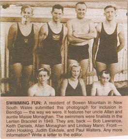
Newspaper - JENNY FOLEY COLLECTION: SWIMMING FUN
Bendigo Advertiser "The way we were" from Saturday, January 15, 2005. Swimming fun: a resident of Bowen Mountain in New South Wales submitted this photo. It features her uncle Allan and auntie Maisie Monaghan. The swimmers were finalists in the Lenten Bracelet in 1949. They are back: Bob Lawrence, Keith Daniels, Allan Monaghan and Lindsay Mann. Front: John Hosking, Judith Eskadale and Paul Walters. The clip is in a folder.newspaper, bendigo advertiser, the way we were -
 Bendigo Historical Society Inc.
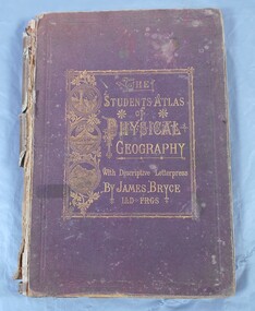
Book - Atlas of Physical Geography
The student's atlas of physical geography consisting of twenty maps, constructed and engraved by Edward Weller F.R.G.S. with descriptive letterpress by James Bryce L.L.D F.R.G.S. Published by William Collins, Sons & Company, London, Glasgow and Edinburgh 1871. Brown cover with the title of the book in gold letters. to the left of the title, also in gold, three circles with different pictures inside. the first of two boats on the sea, a volcanic eruption and a mountain peak.On first page in pencil the name Carrie Van Damme.geography, atlas, 1871 -
![Painting: Park Street [Adeney Avenue] Kew](/media/collectors/550653872162f11fb04854aa/items/5826877cd0cdd11284ad5413/item-media/614ac683a53a0756fd5e49da/item-fit-380x285.jpg) Kew Historical Society Inc
Kew Historical Society IncPainting, Park Street [Adeney Avenue] Kew, c. 1896
‘Adeney Avenue’ was the title given to this painting following its donation to the Kew Historical Society, yet the work’s origins predate the naming of Adeney Avenue in 1907 [originally gazetted as ‘Park Street’ (1865) and ‘Park Street South’ (1875).] Park Street ran between High Street and Parkhill Road beside what was later to become ‘Victoria Park’. This area was described in 1851 as “…a dense forest of gums and wattles which were to be largely cleared by 1888 after the naming of a recreation reserve”. The Reserve was still bisected by an unnamed creek in 1896, when the area was surveyed by the MMBW. The panoramic vista selected by the artist would appear to include ‘Eborensis’ (c.1895) on the corner of Parkhill Road and what was then Park Street, with views across cleared land towards the distant ranges. In the 19th century, north Kew was largely undeveloped farms stretching down to the Yarra. Oil on canvas by an unidentified artist of a panoramic view depicting what is now known as East Kew with mountains on the horizon. In the foreground is a two storey brick residence - Eborensis - located on the northeast corner of Parkhill Road and what is now Adeney Avenue. The view of the landscape and its rolling hills resulted from farming practices adopted following colonisation and settlement. Trees in the foreground and in the distance include remnant Eucalypts and introduced exotics.Label on rear of frame states "House on corner of Adeney Ave & Parkhill. [Regd. 254"]. Otherwise unsigned and undatedadeney avenue (kew), eborensis, park street (kew) -
 Kiewa Valley Historical Society
Photos: Bogong Hotel and Kiewa Valley
The Bogong Hotel was a central point for social gatherings in the Kiewa Valley. It was 125 years old when it was burnt down in December 2011. See KVHS 0965See KVHS 0965Black and white photos framed with thick brown cardboard that is framed by two rows of lines around the photo thus forming a frame. The cardboard is folded in half to form a 'card' enabling the photo to stand. 1. People standing outside the Bogong Pub. The pub is behind trees. Two old/vintage cars are partially in the photo. 2.The Kiewa Valley showing paddocks, trees lining the Kiewa River and mountains in the background.bogong pub, kiewa valley -
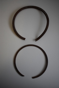 Moorabbin Air Museum
Equipment (item) - Parts Believed To Be Piston Rings From "Southern Cloud" VH-UMF Avro 618-10 ANA
-
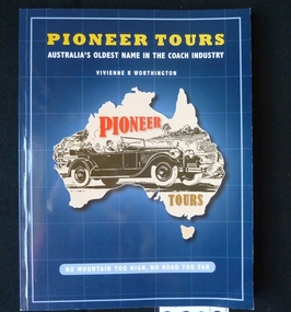 Stawell Historical Society Inc
Book, Vivienne Worthington, Pioneer Tours - Previously Cat No 3622, 2009
A History of the Pioneer ToursBlue card cover with outline of Australia with a car insideYellow Print: Pioneer Tours White Print: Australia's Oldest name in the Coach Industry Vivienne R Worthington No Mountain too high, No road to Far Inside: Presented with Thanks to Stawell Historical Society Inc, for their research which helped me write this book. Best Wishes Vivienne Worthington 2010stawell transport, tourism -
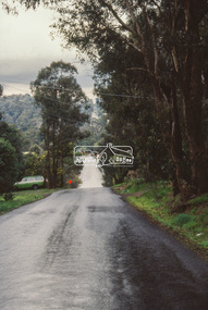 Eltham District Historical Society Inc
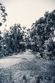
Slide - Photograph, Unidentified location, Eltham district, c.Aug. 1990
Part of a presentation, "Roads and Byways of the Shire of Eltham", by Russell Yeoman to the 12 September 1990 Society meeting. Slides shown included copies of old photos and recent images ranging from the suburban streets of Eltham and Montmorency to the mountain roads of Kinglake. In the byways category are views of some iof the Shire's bicycle paths including then recently completed sections of the Main Yarra Trail at Lower Plenty.35mm colour positive transparency (1 of 37) Mount - Agfachrome Agfa CS System black 8 dotseltham, infrastructure, roads, unidentified -
 Eltham District Historical Society Inc
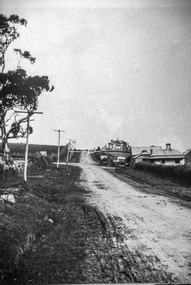
Slide - Photograph, Near the old Lower Plenty Bridge (present day Edward Willis Court), c.Aug. 1990
Part of a presentation, "Roads and Byways of the Shire of Eltham", by Russell Yeoman to the 12 September 1990 Society meeting. Slides shown included copies of old photos and recent images ranging from the suburban streets of Eltham and Montmorency to the mountain roads of Kinglake. In the byways category are views of some iof the Shire's bicycle paths including then recently completed sections of the Main Yarra Trail at Lower Plenty.35mm colour positive transparency (1 of 37) Mount - Agfachrome Agfa CS System black 8 dotsinfrastructure, roads, edward willis court, lower plenty, lower plenty bridge -
 Eltham District Historical Society Inc
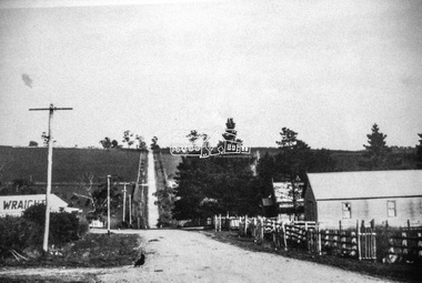
Slide - Photograph, Main Road, Eltham, c.1910, c.Aug. 1990
Part of a presentation, "Roads and Byways of the Shire of Eltham", by Russell Yeoman to the 12 September 1990 Society meeting. Slides shown included copies of old photos and recent images ranging from the suburban streets of Eltham and Montmorency to the mountain roads of Kinglake. In the byways category are views of some iof the Shire's bicycle paths including then recently completed sections of the Main Yarra Trail at Lower Plenty.35mm colour positive transparency (1 of 37) Mount - Agfachrome Agfa CS System black 8 dotsinfrastructure, roads, main road, eltham -
 Eltham District Historical Society Inc
Slide - Photograph, Eltham-Yarra Glen Road, Kangaroo Ground c.1910, c.Aug. 1990
Part of a presentation, "Roads and Byways of the Shire of Eltham", by Russell Yeoman to the 12 September 1990 Society meeting. Slides shown included copies of old photos and recent images ranging from the suburban streets of Eltham and Montmorency to the mountain roads of Kinglake. In the byways category are views of some iof the Shire's bicycle paths including then recently completed sections of the Main Yarra Trail at Lower Plenty.35mm colour positive transparency (1 of 37) Mount - Agfachrome Agfa CS System black 8 dotsinfrastructure, roads, eltham-yarra glen road, kangaroo ground -
 Eltham District Historical Society Inc
Slide - Photograph, Unidentified location, Eltham district, c.Aug. 1990
Part of a presentation, "Roads and Byways of the Shire of Eltham", by Russell Yeoman to the 12 September 1990 Society meeting. Slides shown included copies of old photos and recent images ranging from the suburban streets of Eltham and Montmorency to the mountain roads of Kinglake. In the byways category are views of some iof the Shire's bicycle paths including then recently completed sections of the Main Yarra Trail at Lower Plenty.35mm colour positive transparency (1 of 37) Mount - Agfachrome Agfa CS System black 8 dotsinfrastructure, roads, houses, private street scheme, residential, unidentified -
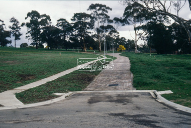
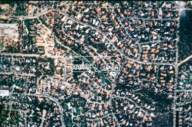
 Eltham District Historical Society Inc
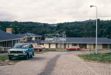
Slide - Photograph, Aerial Photo (c.1987): Main Road, Eltham from Pitt Street to Elsa Court, c.Aug. 1990
Part of a presentation, "Roads and Byways of the Shire of Eltham", by Russell Yeoman to the 12 September 1990 Society meeting. Slides shown included copies of old photos and recent images ranging from the suburban streets of Eltham and Montmorency to the mountain roads of Kinglake. In the byways category are views of some iof the Shire's bicycle paths including then recently completed sections of the Main Yarra Trail at Lower Plenty.35mm colour positive transparency (1 of 37) Mount - Agfachrome Agfa CS System black 8 dotsinfrastructure, roads, aerial photographs, alistair knox park, bridge street, central park, diamond street, elsa court, eltham, eltham common, eltham railway station, eltham town park, main road, pitt street -
 Eltham District Historical Society Inc
Slide - Photograph, Aerial Photo (c.1987): Woodridge Estate, Eltham, c.Aug. 1990
Part of a presentation, "Roads and Byways of the Shire of Eltham", by Russell Yeoman to the 12 September 1990 Society meeting. Slides shown included copies of old photos and recent images ranging from the suburban streets of Eltham and Montmorency to the mountain roads of Kinglake. In the byways category are views of some iof the Shire's bicycle paths including then recently completed sections of the Main Yarra Trail at Lower Plenty.35mm colour positive transparency (1 of 37) Mount - Agfachrome Agfa CS System black 8 dotsinfrastructure, roads, aerial photographs, eltham, housing estate, woodridge estate -
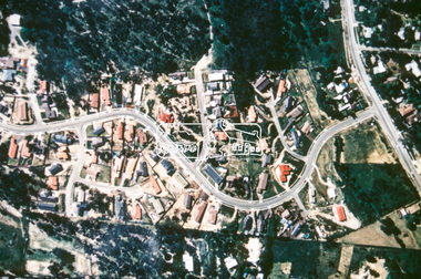 Eltham District Historical Society Inc
Slide - Photograph, Aerial Photo (c.1987): Main Road and Leanne Drive, Eltham, c.Aug. 1990
Part of a presentation, "Roads and Byways of the Shire of Eltham", by Russell Yeoman to the 12 September 1990 Society meeting. Slides shown included copies of old photos and recent images ranging from the suburban streets of Eltham and Montmorency to the mountain roads of Kinglake. In the byways category are views of some iof the Shire's bicycle paths including then recently completed sections of the Main Yarra Trail at Lower Plenty.35mm colour positive transparency (1 of 37) Mount - Agfachrome Agfa CS System black 8 dotsinfrastructure, roads, aerial photographs, eltham, leanne drive, main road -
 Eltham District Historical Society Inc
Slide - Photograph, Aerial Photo (c.1987): Main Road, Fitzsimons Lane, Lower Plenty, c.Aug. 1990
Part of a presentation, "Roads and Byways of the Shire of Eltham", by Russell Yeoman to the 12 September 1990 Society meeting. Slides shown included copies of old photos and recent images ranging from the suburban streets of Eltham and Montmorency to the mountain roads of Kinglake. In the byways category are views of some iof the Shire's bicycle paths including then recently completed sections of the Main Yarra Trail at Lower Plenty.35mm colour positive transparency (1 of 37) Mount - Agfachrome Agfa CS System black 8 dotsinfrastructure, roads, aerial photographs, roundabout, bolton steet, bolton steet shops, eltham, fitzsimons lane, lower plenty, main road -
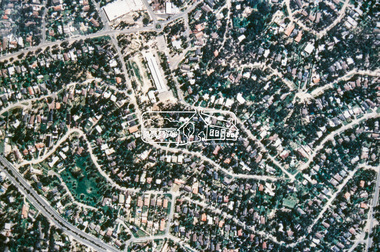 Eltham District Historical Society Inc
Slide - Photograph, Aerial Photo (c.1987): Montmorency South Primary School, Grand Boulevard and Main Road, c.Aug. 1990
Part of a presentation, "Roads and Byways of the Shire of Eltham", by Russell Yeoman to the 12 September 1990 Society meeting. Slides shown included copies of old photos and recent images ranging from the suburban streets of Eltham and Montmorency to the mountain roads of Kinglake. In the byways category are views of some iof the Shire's bicycle paths including then recently completed sections of the Main Yarra Trail at Lower Plenty.35mm colour positive transparency (1 of 37) Mount - Agfachrome Agfa CS System black 8 dotsinfrastructure, roads, aerial photographs, main road, montmorency, montmorency south primary school, grand boulevard