Showing 16744 items matching "1947-1950"
-
 Victorian Railway History Library
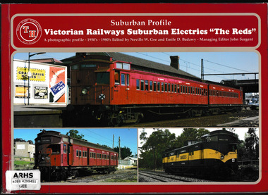
Book, Train Hobby Publications, Victorian railways suburban electrics "The reds" : a photographic profile - 1950's-1980's, 2000
A photographic profile of the period of Tait suburban trains in Melbourne.Ill, p.49non-fictionA photographic profile of the period of Tait suburban trains in Melbourne. suburban railways - melbourne, tait trains - melbourne -
 Ringwood and District Historical Society
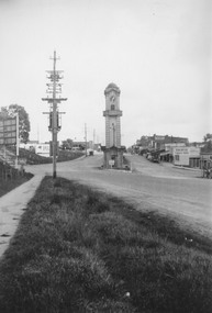
Photograph, Maroondah Highway Central, Ringwood. Clocktower at intersection of Warrandyte Road and Main Street, 1950
Black and white photograph (2 copies- 1 large, 1 small)Typed under large copy: "Maroondah Highway showing cnr Warrandyte Rd, clocktower at old position. Old Station Masters residence, and shops on right which are now demolished for Safeway store." -
 National Vietnam Veterans Museum (NVVM)
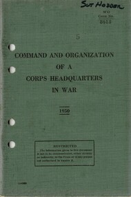
Booklet, Australian Army, Command And Organization Of A Corps Headquarters In War 1950 (Copy 1)
A greenish colour cover with black details. There are four punch holes down the left hand side. At the top of the page is the name Sgt Hodder written in black ink.australia - armed forces - service manuals, drill manual, command and organization, sgt hodder -
 Buninyong Visitor Information Centre
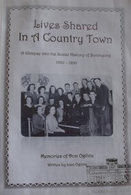
Document (Item) - Book, Joan Ogilvie, Lives Shared in a Country Town - Social History of Buninyong 1930 - 1950, 2010
Provides memories of Don Ogilvie of individual people who lived in Buninyong from the 1930s to the 1950s. Transcribed by Joan Ogilvie.Buninyong Library ID stamp on cover.buninyong residents, social history, life in 1930s to 1950s -
 Eltham District Historical Society Inc
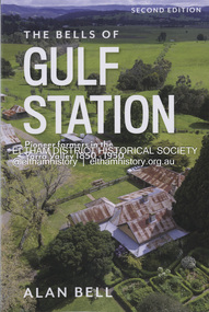
Book, Alan Bell, The Bells of Gulf Station: Pioneer farmers in the Yarra Valley 1850-1950; Second Edition, 2024
This book is the product of research into the author's branch of the Bell family who emigrated from Scotland to Australia in 1839, with a particular focus on the direct forebears who pioneered Gulf Station in the early 1850s and continued to reside at and manage the property for another 100 years. In this revised edition, newly acquired insights into the personalities and activities of those ancestors at Gulf Station are included.bell family, farms, gulf station, pioneer family, yarra valley, yarra glen -
 Eltham District Historical Society Inc
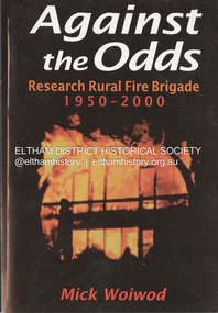
Book, Mick Woiwod, Against the Odds; Research Rural Fire Brigade 1950-2000, c.2001
A history of the brigade's first 50 yearsbushfire, eltham barrel, research fire brigade, victorian bushfires - 1969 -
 Victorian Railway History Library
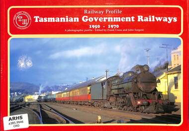
Book, Train Hobby Publications, Railway Profile Tasmanian Government Railways 1950-1970, 1998
A photographic profile of the Tasmanian Government Railways between 1950 & the 1970s.Ill, p.48.non-fictionA photographic profile of the Tasmanian Government Railways between 1950 & the 1970s.railroads - tasmania - history, railroads - tasmania - pictorial works -
 Merbein District Historical Society
Photograph, Cowanna Bend Early 1950's Start of washout, c.1953
cowanna washout, murray river -
 Merbein District Historical Society
Photograph, Cowanna Bend cutoff towards Coomealla 1950, unknown
murray river, cowanna bend cutoff, coomealla -
 Linton and District Historical Society Inc
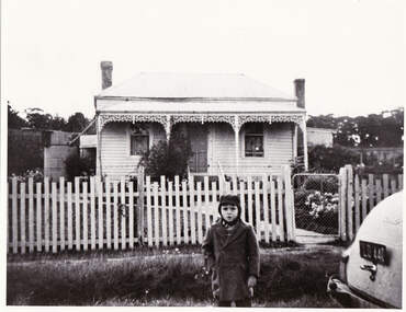
Photograph, Nelson Family House, Brooke Street, Linton, circa 1950
Black and white photograph of single-fronted house with verandah and iron lace. A young child, understood to be a Nelson descendant, is standing outside front picket fence, wearing winter coat and hat. Part of a car is visible on lower right side of photograph.houses, nelson family -
 Damascus College
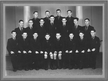
Photograph, St Paul's Technical College Ballarat first graduating class - Form III 1950
St Paul's Technical College Ballarat was established in 1948. The Junior Technical Certificate was awarded after three years.Digital imagejunior technical certificate, catholic education, st paul's college, christian brothers -
 Ringwood and District Historical Society
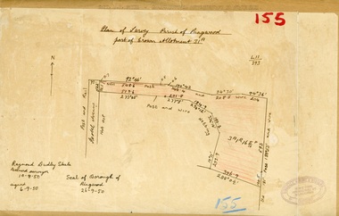
Map, Plan of Survey, Parish of Ringwood - Part of Crown Allotment 31A - 1950
Hand drawn and labelled copy of map with survey measurements of allotment on Isobel Avenue (Isabel Avenue?), Ringwood East. Raymond Dudley Steele Licensed Surveyor 10-8-50, signed 6-9-50, Seal of Borough of Ringwood 26-9-50. Rubber stamp - Dugdale, Simmons & Stevens, Solicitors, Peacock House, 486 Bourke Street Melbourne. Typewritten heading on backing paper - Capt. M.H. Moyes - Correspondence Supplementary to Statements. -
 Box Hill Historical Society
Book, Armin Richter et al, The Charge of the White Horse Brigade: a history of the Box Hill Football Club. Part One - 1888 to 1950, 2016
Story of the Box Hill Football Club. Includes match results and provides historical context of the development of football in the City of Box Hill.146 pages; b&w and colour photosStory of the Box Hill Football Club. Includes match results and provides historical context of the development of football in the City of Box Hill.sports and recreations, football, box hill football club -
Camberwell Historical Society
Booklet (Item), Jill Howie, Solway Primary School 1950-1982, 1982
camberwell, solway primary school, ashburton, school -
Moorabbin Air Museum
Book - AUSTRALIA IN THE KOREAN WAR 1950-53, Robert O'Neill, 1985
-
 Ringwood and District Historical Society
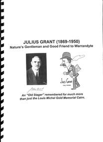
Book, Julius Grant (1869-1950) Nature's Gentleman and Good Friend to Warrandyte
Bound compilation of notes about Julius Grant, Park Orchards orchardist, and his involvement with the Warrandyte community, Shire of Doncaster and Templestowe as Councillor, and participant in a Cairn Committee for erection of memorial at Anderson's Creek in Warrandyte marking Louis J. Michel and party rewarded by Government as discoverers of first goldfield in Victoria. Also includes substantial coverage of Grant's theatrical involvement, Australian films, and Adam Lindsay Gordon Memorial Committee. "An Old Stager remembered for much more than just the Louis Michel Gold Memorial Cairn." -
 Ringwood and District Historical Society
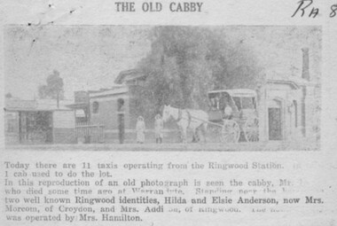
Newspaper, 1950 newspaper clipping featuring circa 1920 photograph of Mr William Hussey and his horse-drawn cab at Ringwood Railway Station, with Hilda and Elsie Anderson standing near the horses
Ringwood Mail newspaper clipping - 7/12/50. Heading of article, "The old cabby". Printed below picture, "Today there are 11 taxis operating from the Ringwood Station. 1 cab used to do the lot. In this reproduction of an old photograph is seen the cabby, Mr.Hussey who died some time ago at Warrandyte. Standing near the horses are two well known Ringwood identities, Hilda and Elsie Anderson, now Mrs. Morcom, of Croydon, and Mrs. Addison, of Ringwood. The newsagency was operated by Mrs. Hamilton". -
 Ringwood and District Historical Society
Document - Research Notes, Richard Carter, Land Subdivisions in Ringwood 1890-1950
Handwritten table listing main local pre-1950s subdivisions in the Ringwood area, with estate names, streets, number of allotments for sale, and where known, vendor agent, LP (Lodged Plan) title registration number, and auction/sale date, some with sale price.Pg1 RINGWOOD STATION ESTATE LP3070 (Year?) Station Street, William Street (now Kendall Street), Wantirna Road, Station Street Pg1 RINGWOOD TOWNSHIP ESTATE LP5577 (1913) Station Road (now Warrandyte Road), Pratt Street (part now Aird Street), Whitehorse Road Pg2 RINGWOOD ORCHARD ESTATE LP4315 (1914) Brysons Road, Hillcrest Road, Anzac Avenue, Sulva Road Pg3 RINGWOOD RAILWAY ESTATE LP7522 (1918) Whitehorse Road (now Mount Dandenong Road), Dublin Road, Freeman Street, Patterson Street, Bona Street Pg4 THE RINGWOOD ESTATE LP7578 (1919) Warrandyte Road, Hobart Street, Paxton Street, Arnold Street Pg5 GARDEN FARMS ESTATE (LP?) (1919) Canterbury Road, Armstrong Road, Bungalook Road, Orchard Road, Bayswater Road (now Mountain Highway) Pg6 THE RINGWOOD ESTATE (SECOND SUB-DIVISION) LP7604 (1919) Warrandyte Road, Tamar Street, Derwent Street, Mersey Street Pg7 RINGWOOD STATION ESTATE LP7703 (1919) Bedford Road, Williams Grove (now Lena Grove) Pg8 RINGWOOD TOWNSHIP ESTATE LP8198 (1919) Wantirna Road, Ellison Street, Haig Street, Greenwood Avenue Pg9 EASTFIELD ESTATE (LP?) (1920) Eastfield Road, Longview Road, Pleasant Rise, The Mount Pg10 ELECTRIC RAILWAY ESTATE RINGWOOD LP9473 (1922) Campbell Street, Myrtle Avenue, George Street (now Tudor Court), Henry Street (now Myrtle Avenue), Williams Grove (now Lena Grove) Pg11 RINGWOOD PARK ESTATE LP7884 (1922 - two stages) Wonga Road (now Loughnan Road), William Street, Andrew Street, Harrison Street Pg12 HEATHMONT STATION ESTATE LP11009 (Date? - after 1922) Lisgoold Street, Viviani Crescent, Balrour Avenue, Station Street (now part Heathmont Road and part Wainui Street) Pg13 RINGWOOD RAILWAY ESTATE LP10507 (1923) Whitehorse Road, Sherbrooke Avenue, Burwood Avenue, Bonview Avenue, Heatherbrae Avenue, Grant Crescent Pg14 GARDEN HOMES ESTATE (LP?) (1923) Mullum Road, The Centreway, Wattle Crescent (now Wattle Avenue) Reserve Crescent (now Reserve Road) Pg15 DUBLIN ROAD ESTATE LP11993 (1923) Alexandra Road, Vonadawn Avenue, Green Street, Wood Street, Howard Avenue, Bedford Road, Dublin Road Pg16 CARLINGA ESTATE RINGWOOD LP9620 (1923) Bourke Street, Bond Street, Ringwood Street Pg17 PRATT'S JUNCTION ESTATE (LP?) (1923) Junction Street, Georges Road, Oliver Street, Whitehorse Road Pg18 EAST RINGWOOD ESTATE LP10492 (1923) Bona Street, Patterson Street, Miller Grove, Fairview Avenue, Eastfield Road, Whitehorse Road (now Mount Dandenong Road) Pg19 COLEMAN'S HEATHMONT ESTATE LP9974 (1923) Canterbury Road, Bedford Road, Alvena Crescent, Coleman Street, Leonard Street (now Royal Avenue) Pg20 RINGWOOD HEIGHTS ESTATE LP10506 (1924) Whitehorse Road, Bonview Avenue, Grant Crescent, Hillcrest Avenue, Heatherbrae Avenue, Margaret Street, Mary Street Pg21 EAST RINGWOOD STATION ESTATE LP10551 (1924) Knaith Road, Wenwood Street, Lois Street, Victoria Street, Station Street (now Railway Avenue) Pg22 GRAND VIEW ESTATE LP11019 (1924) Whitehorse Road, Rupert Street, Herbert Street, Leonard Street Pg23 RINGWOOD RAILWAY ESTATE & RINGWOOD HEIGHTS ESTATE - FINAL SECTIONS LP10506 & LP10507 (1924) Whitehorse Road, Sherbrooke Avenue, Burwood Avenue, Bonview Avenue, Heatherbrae Avenue, Margaret Street, Mary Street, Grant Crescent Pg24 RINGWOOD EAST ELECTRIC STATION ESTATE (LP?) (1924) Railway Parade (now Patterrson Street), Federal Road, Howship Avenue (part now French Street), Dublin Road, Rosedale Crescent Pg25 BEDFORD PARK (now Ringwood Secondary College) (LP?) (1924) Bedford Road, Adams Street, Anderson Street, Joyce Street, Graham Road Pg26 CROWN JEWEL ESTATE LP11645 (Private sales after 1924) Mount Dandenong Road, Mirabel Avenue, Valda Avenue, Evon Avenue, Velma Grove Pg27 GRAND CENTRAL ESTATE LP10917 (1925) Heathmont Road, Great Ryrie Street, Douglas Street, Garden Street, Bellevue Avenue Pg28 RINGWOOD (unnamed estate - 1926) Nelson Street, Seymour Street, Whitehorse Road Pg29 EAST RINGWOOD RAILWAY STATION ESTATE (YEAR? - 25 shops 60 villas) Railway Avenue, Dublin Road, Lawrence Grove, Stanley Avenue, Knaith Road Pg30 CHARM VIEW ESTATE (LP?) (year? - after 1926) Canterbury Road, Heathmont Road, Dickasons Road, Bennjett Avenue, Orchid Street Pg31 SUNBEAM ESTATE LP12150 (Circa 1925) Govt Road (now Old Lilydale Road), Sunbeam Avenue, Holland Road, Everard Street (now Everard Road) Pg32 FAIRVIEW ESTATE EAST RINGWOOD LP10853 (Circa 1924) Eastfield Road, Patterson Street, Margaret Street (now Short Street) Pg33 EAST RINGWOOD TOWNSHIP ESTATE LP3025 (Circa 1924 - 35 allotments) Mount Dandenong Road, Grey Street, Eastfield Road Pg34 EAST RINGWOOD TOWNSHIP ESTATE LP3025 (Circa 1924 - 49 allotments) and STATE SCHOOL ESTATE (26 allotments) and EAST RINGWOOD STATION ESTATE (14 shop sites) Mount Dandenong Road, Grety Street, Dunn Street, Eastfield Road, King Street, Holland Road, Dublin Road, Patterson Street, Bona Street Pg35 EAST RINGWOOD CENTRAL ESTATE LP17004 (1948) Knaith Road, Shasta Avenue, Talofa Avenue, Russet Road, Dublin Road Pg36 WARE ESTATE LP43360 (1958) Ware Crescent, Davey Drive, Grey Road (now Grey Street), Mount Dandenong Road Pg37 Lot 57 Kendall Street LP3070 (1939) £75.0.0 Pg37 Lot 14 LP7346 (year?) £225 Pg37 Lot 8 WHITE HORSE ESTATE LP14010 (year?) Maroondah Hwy, Seymour Street £98.9.0 Pg37 Lots 4-14 incl. LP10902 (year?) £300 Pg37 Lots 69&70 LP2216 (1939) Bedford Road, Pitt Street £500 Pg37 Lots 60&70 LP2216 (year?) £460 Pg37 MOUNTAIN VIEW ESTATE LP10902 (1936) Lots 1&2, 19-22 Wantirna Road, Daisy Street £50 Pg38 RAILWAY STATION ESTATE RINGWOOD EAST LP7522 (1925) Lots 16 to 19 £250 Pg38 RINGWOOD PARK ESTATE (LP?) (1924) Lot 112 Munro Street £230 Pg38 RINGWOOD TOWNSHIP ESTATE (LP?) (1925) Lot 57 Wantirna Road £850 Pg38 ELECTRIC RAILWAY ESTATE LP9473 (1925) Lot 98 & 99 £180 (30/- foot) Pg38 ELECTRIC RAILWAY ESTATE LP9473 (year?) Lot 100 £233.12.6 incl improvements (£2.12.6 foot) Pg38 Lot 22&23 Bedford Road Heathmont (LP & year?) £675 incl improvements Pg39 Lot 9 Mullum Mullum Road LP8221 (1923) £150 Pg39 Lot 27 Haig Street LP8198 (1925) £825 Pg39 Lot 56 Haig Street cnr Wantirna Road LP8198 (1923) £171 Pg39 Lots 3 & 4 Loughnan Road LP9626 (192?) £147 Pg39 Lots 98 & 99 Myrtle Avenue LP9473 (1925) £180 Pg39 Lots 80 & 81 Myrtle Avenue LP9473 (1929) £150 Pg39 Lot 30 Sherbrooke Avenue LP10507 (1926) £700 incl improvements Pg40 Lot 10 (year?) LP7703 £750 Pg40 Lot 36 (year?) LP7522 £25 Pg40 Lot 38 Pitt Street LP2216 (year?) £350 Pg40 Lot 7 Dublin Road cnr Green Street LP11993 (year?) £300 -
 Ringwood and District Historical Society
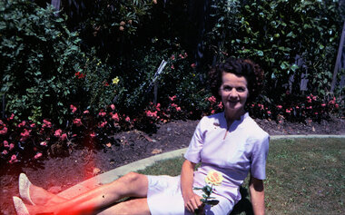
Negative, Photographic negatives from Archie and Ruby Harker Collection - Early 1950's to Mid 1960's, B&W and Colour
Archir Harker was married to Ruby Wilson and mentioned in the "Wielands of Heathmont "book. From Greg Coker: In August 2023, RDHS asked Greg Coker to scan a set of negatives. He was able to work out, through various notes, that the pictures were taken by J A Harker of 9 Grange St, Mont Albert in the mid 50s to the mid 60s. Most of the film was 9cm X 6cm B&W negatives. All pictures have been cropped and where appropriate, put through a light filter. They have been scanned at 1600ppi resulting in ~3meg B&W shots (~5meg for the half dozen colour shots). The Harkers certainly liked their hiking – they were ahead of their time. Images scanned from Kodakl packet of negatives, undated. After scanning in 2023 by Greg Coker, the negatives and packet were. Some photos may be duplicated in other VC Harker/Weiland family records if the original prints were donated. Greg's comments: Early 50s to Mid 60s – Original colour & B&W negatives Largest packet of negatives with multiple sets clearly combined in this one envelop These were made up of: - 8 colour 9X6cm negatives – late 60s - ~40 B&W 9X6cm negatives – Early - late 50s - 3 large B&W 12x9cm negatives – Mid 50s Most of the pictures in this set are portraits pictures of Mr or Mrs Harker. Many in the front and back yards of 9 Grange street, Mont Albert. A few negatives of Phillip Island here also (Identified the Nobbies). Kodacolor Prints. -
 Ringwood and District Historical Society
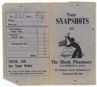
Negative, Photographic negatives from Archie and Ruby Harker Collection - Mid 1950's Mountains - possibly Grampians
Archir Harker was married to Ruby Wilson and mentioned in the "Wielands of Heathmont "book. From Greg Coker: In August 2023, RDHS asked Greg Coker to scan a set of negatives. He was able to work out, through various notes, that the pictures were taken by J A Harker of 9 Grange St, Mont Albert in the mid 50s to the mid 60s. Most of the film was 9cm X 6cm B&W negatives. All pictures have been cropped and where appropriate, put through a light filter. They have been scanned at 1600ppi resulting in ~3meg B&W shots (~5meg for the half dozen colour shots). The Harkers certainly liked their hiking – they were ahead of their time. Images scanned from The Block Pharmacy packet of negatives, undated. After scanning in 2023 by Greg Coker, the negatives were disposed and just the packet retained. Some photos may be duplicated in other VC Harker/Weiland family records if the original prints were donated. Greg's comments: Mid 50s – Original B&W negatives; Seems to be a set of holiday snaps in mountain country – the Grampians I think. Your Snapshots by The Block Pharmacy (J.H. Beyer Ph.C, M.P.S.), 102 Elizabeth Street, Melbourne C1. Telephone MF 1380 -
 Ringwood and District Historical Society
Photograph, Ringwood State School - Mr Dennis, Grade 3 teacher, 1950
Black and white photograph -
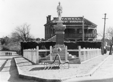 Stawell Historical Society Inc
Photograph, Coffee Palace and Soldiers memorial 1950's
Taken Cnr Main & Victoria StreetsPhotograph of Soldiers Memorial in front of Coffee Palace formerly Castlemaine Hotel, at Corner of Lower Main Street and Victoria Street.From Joan Britton (Taylor) Nee Ellisstreetscape, ww1, ww2 -
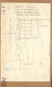 Ringwood and District Historical Society
Map - Plan of Subdivision, Part of Crown Portion 7, Parish of Ringwood, County of Mornington - circa 1950
Hand-drawn map attached to light cardboard backing showing 5 residential allotments on eastern side of Maidstone Street Ringwood, north of Canterbury Road.RFK 8/11/51 -
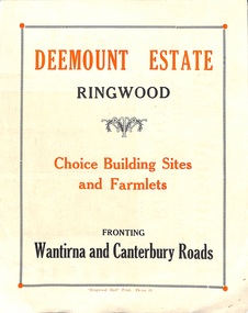 Ringwood and District Historical Society
Flyer, Subdivisional Land Sale advertisement - Deemount Estate, Ringwood, Vic. - c.1950
Double sided folded page with black and orange advertisement and blueprint for Deemount Estate fronting Canterbury and Wantirna Roads, Ringwood, with handwritten price list and terms of sale. Additional undated hand-drawn map on light cardboard - 4 allotments on western side of Maidstone Street .Subdivision includes Canterbury Road, Wantirna Road and Maidstone Street. -
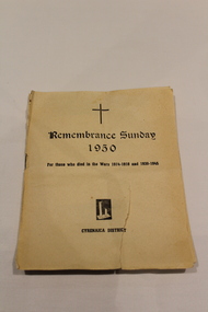 Dandenong/Cranbourne RSL Sub Branch
Booklet, Remembrance Sunday 1950
Cream Booklet with order of Service. Cover "For those who died in the Wars 1914-1918 and 1939-1945". Cyrenaica District of Libya and Tripoli. -
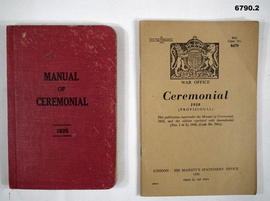 Bendigo Military Museum
Manual - CEREMONIAL, British War Office, 1. Manual of Ceremonial 1935. 2. Ceremonial 1950 Provisional, 1935
Items in the collection re Lt Col J. Swatton, refer Cat No 6719.2P for his service details.1. This is a pocket sized booklet. Cover is red buckram. printing in black ink. Inside are printed descriptions of drill movements for ceremonies. It also has B & W photos of a soldier demonstrating funeral (?) positions and paces. It has 171 pages plus end plates. There are some modification slips glued in there. 2. This is a khaki coloured, covered pocket book. It has the Crest of Great Britain top centre. In the centre is the title and above that is supersedes 1935 edition.1. Inside front cover, written in ink is "V59401 Col. J.W. Swatton, 4 Div". On first page it looks like the original owner's name has been cut out. 2. On rear cover is a sticky label "On loan from the Estate of Colonel J.W. Swatton".passchendaele barracks trust, booklets drills and ceremonial -
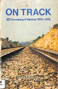 Victorian Railway History Library
Book, Affleck, Fred, On Track - The making of Westrail 1950-1976, 1978
An illustrated history of the making of Westrail, the re-branded Western Australian Government Railways, from 1950 to 1976.index, ill, maps, p.232.non-fictionAn illustrated history of the making of Westrail, the re-branded Western Australian Government Railways, from 1950 to 1976.railroad trains -- australia -- history., railway history - western australia -
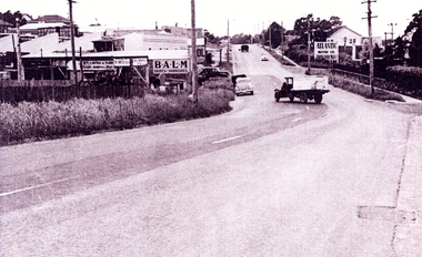 Whitehorse Historical Society Inc.
Photograph - Black and white photograph, Burwood Road, East Burwood 1950,s, c1950
Black and white photograph of an ice cart on Burwood Road, East Burwood and on the north side the business of W.Smith & Son.|The occupants of the properties from the corner of Middleborough and Burwood Roads - north side were in 1923 (Sands & McDougall) Woolard, Bennett,Christensen and Fullton. Royton Street W. Smith & sonburwood road, burwood east, woolard, bennett, christensen, fullton., royton street burwood east, w. smith & son -
Ringwood and District Historical Society
Administrative record - Minutes, Ringwood Cool Stores Co-operative Society Ltd - Minutes Book-Minutes 1950-1951
Scanned copy of Minutes of the Ringwood Cool Stores Co-operative Society Ltd for the years specified. The originals are in the large Kalamazoo Binder referred to in VC Record 11220. coolstores -
 Ringwood and District Historical Society
Map - Plan of Subdivision, Part of Crown Allotment 43, Parish of Ringwood, County of Mornington - (Circa 1950)
Copy of land title map in manilla folder showing layout and size of seven residential allotments (Lots 1 to 4 and 17 to 19) in Canterbury Road Heathmont, north-east of Bedford Road corner.Ronald G. Lee Licensed Surveyor, 195 Bridge Road, Richmond. Tel 42-6356.