Showing 177313 items matching "27-schutt-street"
-
 Bacchus Marsh & District Historical Society
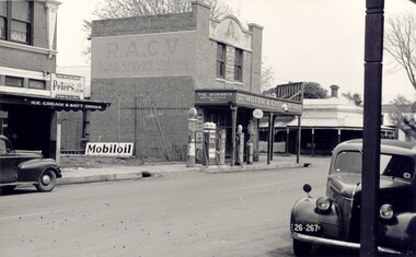
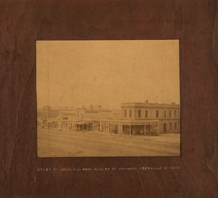
Photograph, Simon Brothers Motor Garage corner of Main Street and Grant Street c.1940s
This image shows one of the busiest intersections of Bacchus Marsh, the corner of Main and Grant Streets. The main building shown in the image is Simon Brothers Motor Service and Cycle Depot. In 1903 the Simon brothers, Herbert (Bert) and Walter began making Monarch bicycles and later Monarch motor cycles. In 1913 they moved into newly constructed premises shown in this image. The business operated as both a garage, service station and cycle depot. The business operated until 1948 when P. S. Carey brought the premises to expand his Grant Street car dealership business which was located next to the Simon Brothers garage. Black and white photograph showing Simon Brothers Motor garage Bacchus Marsh seen from the northern side of Main Street looking south west towards Grant Street. BMDHS Location: AR/R4/S2 Photo Album Jack Coe Collection, and digital image on BMDHS computer network.On reverse, "Jack Coe Collection"small businesses bacchus marsh, simon family bacchus marsh, simon brothers garage, petrol stations -
 Federation University Historical Collection
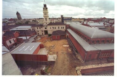
Photograph - Coloured photograph, Arts Academy at Camp Street under construction, 2003/2004
Coloured photographs showing the area to be built on. The Mining Exchange and Ballarat Post Office are shown. These buildings plus new ones will make up the Federation University Camp Street campus.arts academy, camp street, construction, former ballarat library -
 Whitehorse Historical Society Inc.
Photograph, 22 Pakenham Street, Blackburn, C.1950
Black and white photo of 22 Pakenham Street, Blackburn, looking West. Left hand corner is the dirt strip of Salisbury Avenue, Blackburn, heading up the hill to Middleborough Road. -
 Stawell Historical Society Inc
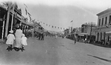
Photograph, Main Street Stawell at Easter looking West with the Post Office on the right
Easter celebrations in Main St. Stawell. The photo is taken looking west c 1930. Post Office building is on the right with bunting hanging over the building and down the main street. The street must have been closed to traffic as people are walking up and down the street. A woman with two children are on the left of the photo. One small black & white photo and a enlarged copy. The photograph was taken at Easter celebrations in Main street looking west. A woman with 2 children either side of her on the left of the photograph. Bunting is hanging along the Main street.Main St ? Datestawell business streetscape -
 Federation University Historical Collection
Photograph, Sturt Street, Ballarat from Albert Street, 1864
Framed photograph pf the Southside of Sturt Street Ballarat from Albert Street towards Grenville Street 1864.ballarat, street street -
 Stawell Historical Society Inc
Photograph, Hobbs Family House at 10 Seaby Street Stawell 1997
Built by Mary Ellen Hobbs of Seaby Street widow of William Hobbs.B/W photograph of substantial brick home at 10 Seaby Street. stawell -
 Rutherglen Historical Society
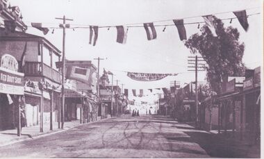
Image, c1920-1930
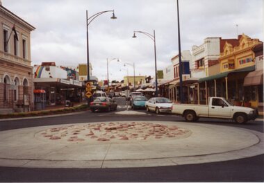
This view of Rutherglen shows, on the left: Red Boot Shop, Victoria Hotel, Quon Fruit Shop and Bank of Australasia. Banner across street reads in part "M.U.I.O.O.F. Welcomes Old Bros." MUIOOF is the Manchester Unity Independent Order of OddfellowsOne of three black and white photographs mounted on orange paper. This one is a view of Main Street looking west.Written on mount: "Main Street looking west from roundabout. Circa 1920-30"main street, red boot shop, victoria hotel, quon family, bank of australasia, muioof, manchester unity independent order of oddfellows, shops, hotels, banks -
 Hume City Civic Collection
Manual - Street Directory, Morgan's Official Street Directory of Melbourne and Suburbs, 1980's
This street directory of Melbourne and Suburbs was the 52nd edition published by Val Morgan. It is printed with a new map format.A Morgan's street directory of Melbourne and Suburbs without a front cover.morgan, val and co., melbourne, directories, street directories, george evans collection -
 Stawell Historical Society Inc
Photograph, Stawell Police Station in Patrick Street 1991-92
New Stawell Police Station Building commenced March 1991 Patrick StreetColour photograph of New Police Station in Patrick Street March 1991stawell -
 Stawell Historical Society Inc
Photograph, Railway Yards looking towards Napier Street
Railway Yards Stawell looking towards Napier Street from Wakeham Street. Water tank at right of photo.Looking towards Napier Street, across the railway yards, a water tank is on the right, this was used for steam engines.stawell railways transport -
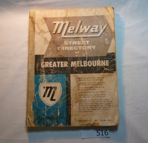 Greensborough Historical Society
Book, Melway Street Directory of Greater Melbourne. Edition 1, 1966_
The first edition of this iconic Melbourne street directory published in 1966. The directory is accompanied by an outline of the history of the concept and publication of Melway.A surviving first edition of the Melway is rare as these directories are designed to be updated each year. Of interest in this edition is maps of the Greensborough area before large scale subdivision of the land in the late 1960s and 1970s.Soft cover street directory. Coloured maps.189 pages.melway, street directories, melbourne. -
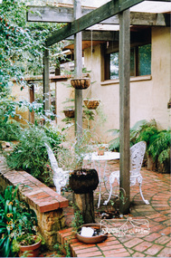 Eltham District Historical Society Inc
Photograph, 7 Peter Street, Eltham, June 1990
Brick paving and garden at the front of "St Erth" Peter Street, Eltham. This was an owner-built pise house constructed in 1951.Colour photograph of front view of 7 Peter Street, Elthamhouses, pise construction, st erth, peter street, eltham -
 Eltham District Historical Society Inc
Photograph, Brisbane Street, Eltham (unmade) from west end, 1969, 1969
Brisbane Street, Eltham (unmade) from west end, showing light industrial area 1969black and white photograph with white borderverso: Brisbane Street before road made 1967 looking east eltham, 1969, roads, streets, brisbane street, light industrial area -
Tatura Irrigation & Wartime Camps Museum
Photograph, W. Purcell, Park Street Railway Crossing
photograph of group of men at Park Street Railway Crossing Tatura.Black and white photograph of group of men at Park Street Railway Crossing Tatura. -
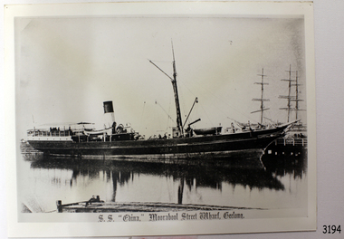 Flagstaff Hill Maritime Museum and Village
Photograph, S.S. "EDINA," Moorabool Street Wharf, Geelong, c. 1870's - 1930's
This black and white photograph was taken when the SS Edina was as port at the Gellong Wharf in Moorabool Street. The Port of Geelong had many wool sheds alongside the wharf - wool was a major export product. ABOUT THE S S EDINA The three masted iron screw steamer SS Edina was built in Glasgow, Scotland, in 1854 by Barclay and Curle. She was adorned with the figurehead of ‘fair maid of Judea’. The many years of service made SS Edina famous world-wide as the longest serving screw steamer. (The term screw steamer comes from being driven by a single propeller, sometimes called a screw, driven by a steam engine.) SS Edina’s interesting history includes English Chanel runs, serving in the Crimean Ware carrying ammunition, horses and stores to the Black Sea, and further service in the American Civil War and later, serving in the western district of Victoria as well as in Queensland and carried gold, currency and gold prospectors Australia to New Zealand. SS Edina had the privilege of being an escort vessel to H.R.H. the Duke of Edinburgh during his visit to Australia in 1867. In March 1863 SS Edina arrived in Port Phillip Bay, Melbourne and was bought by Stephen Henty, of Portland fame, to work the cargo and passenger run from Melbourne – Warrnambool – Port Fairy - Portland. After a short time of working the run from Australia to New Zealand, with passengers and cargo that included gold and currency, she returned to her Melbourne - Warrnambool – Port Fairy run, with cargo including bales of wool produced in the western district of Victoria. The Warrnambool Steam Packet Company purchased SS Edina in 1867; she was now commanded by Captain John Thompson and Chief Engineer John Davies. She survived several mishaps at sea, had a complete service and overhaul and several changes of commanders. In 1870 SS Edina was in Lady Bay, Warrnambool, when a gale sprung up and caused a collision with the iron screw steamer SS Dandenong. SS Edina’s figurehead was broken into pieces and it was not ever replaced. SS Edina was re-fitted in 1870 then was used as a coastal trader in Queensland for a period. She was then brought to Melbourne to carry cargo and passengers between Melbourne and Geelong and performed this service 1880-1938. During this time (1917) she was again refitted with a new mast, funnel, bridge and promenade deck, altering her appearance. In 1938, after more collisions, SS Edina was taken out of service. However she was later renamed Dinah and used as a ‘lighter’ (a vessel without engine or superstructure) to be towed and carry wool and general cargo between Melbourne and Geelong. In 1957, after 104 years, the SS Edina was broken up at Footscray, Melbourne. Remains of SS Edina’s hull can be found in the Maribyrnong River, Port Phillip Bay. [Reference: A Brief Review of Steam Navigation in Victoria; C Dickson Gregory; Centenary Maritime Exhibition catalogue, 1934; published by Shiplovers' Society of Victoria Dandenong, Passengers in History, http://passengersinhistory.sa.gov.au/node/924034 Edina, Victorian Heritage Database VHR S199 http://vhd.heritage.vic.gov.au/shipwrecks/heritage/199 SS Edina, Coastal Trader and Passenger Ship 1853-1938, Museum Victoria Collections, https://collections.museumvictoria.com.au/articles/6227 SS ‘Edina’ – the Longest Serving Screw Steamer in the World, POI Australia, https://poi-australia.com.au/ss-edina-the-longest-serving-steamer-in-the-world/ ]This postcard of the SS Edina is significant for its association with the screw steamer SS Edina and shows her at one of her trading ports on the Melbourne - Warrnambool - Port Fairy - Portland run. The SS Edina is heritage listed on the Victorian Heritage Database VHR S199. She had endeared herself to the people of Port Phillip Bay as a passenger ferry, part of their history and culture. She played a significant role in the Crimean War, the American Civil War and the gold rush in New Zealand. She also served western Victoria for many years in her cargo and passenger runs. The SS Edina is famous for being the longest serving screw steamer in the world. After spending her first nine years overseas she arrived in Melbourne and her work included running the essential service of transporting cargo and passengers between Melbourne and the western Victoria ports of Warrnambool, Port Fairy and Portland. The SS Edina was purchased in the late 1860’s by local Warrnambool business, the Warrnambool Steam Packet Co. and continued trading from there as part of the local business community. The SS Edina’s original ‘fair maid of Judea’ figurehead was broken to pieces in a collision with another vessel (the SS Dandenong) in a gale off Warrnambool, Victoria, in 1870.Black and White photograph of S.S Edina at the Moorabool Street Wharf, Geelong in calm water that shows the reflection of the steamer. Ship has no sails raised. The funnel has a light coloured base with a dark coloured top. There are people on board the steamer. Other ship masts and people are in the background. In the foreground is a jetty with a small boat beside it and a person inside the boat. There is a title printed along the base of the photograph. c. 1870's to 1930'sPrinted at base of photograph "S.S. "EDINA," Moorabool Street Wharf, Geelong"warrnambool, shipwrecked coast, flagstaff hill, flagstaff hill maritime museum, maritime museum, shipwreck coast, flagstaff hill maritime village, shipwrecked artefact, barclay & curle, figurehead 'fair maid of judea', centenary maritime exhibition 1934, a brief review of steam navigation in victoria, pleasure steamer edina, trade and travel late 19th and early 20th century, trade melbourne to geelong, screw steamer edina, coastal trader edina, lighter dinah, cargo carrying for cremean war, cargo carrying for american civil war, passenger and trade in western district of victoria, export gold and currency and gold diggers to new zealand, export vessel to h r h the duke of edinburgh, melbourne - warrnambool - port fairy - portland cargo run, warrnambool steam packet company, stephen henty, captain john thompson, chief engineer john davies, lady bay warrnambool, lighter edina, shipping victoria, port phillip bay steamers, steamship great britain, edina, vhr s199 victorian heritage database, postcard of ss edina 1870's - 1930's -
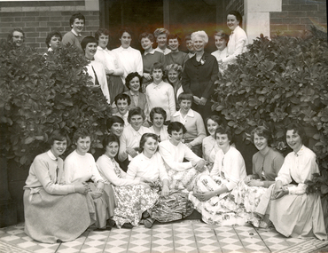 Federation University Historical Collection
Photograph - Photograph - Black and white, Ballarat Teachers' College Resident's at 130 Victoria Street, Ballarat East, 1960s, 1960s
A number of female student teachers of the Ballarat Teachers' College pose at the front of their hostel at 130 Victoria Street, Ballarat East. Mavis Canty stand centre right in dark dress with a rose on the collar.Written on back "Ballarat Teachers' College, Mavis Canty with girls of the Ballarat Teachers College Hostel, 196-"ballarat teachers' college, 130 victoria street, hostel -
Whitehorse Historical Society Inc.
Document, McDowall Street, Mitcham, 1/07/1999
Auction brochure for 4 bedroom brick veneer house, 24 McDowall Street, Mitcham, formerly Kennedy family home, 17 July 1999. Agent, Cody First National Real Estate.mcdowall street, mitcham, no. 24, kennedy, archibald francis -
 Linton and District Historical Society Inc
Photograph - Postcard, Post Office, Sussex Street, Linton
Black and white postcard photograph of the Linton Post Office in Sussex Street. Part of the Bank of New South Wales building can be seen on the left. The building is still standing but is now in private hands.post offices, buildings, linton -
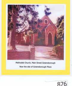 Greensborough Historical Society
Photograph, Unknown, Methodist Church Main Street Greensborough, 1940c
The Greensborough Methodist Church stood in Main Street Greensborough and was central to the social life of the suburb in the early 20th century. This original site is now part of the Greensborough Plaza shopping complex. The Church moved to the new building in Grimshaw Street circa 1970s. This photograph shows the red brick church, now demolished.Copy of colour photograph of red brick church, mounted on yellow card and laminated.Caption: 'Methodist Church, Main Street Greensborough. Now the site of Greensborough Plaza'methodist church greensborough -
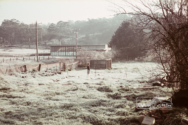 Eltham District Historical Society Inc
Photograph, Russell Yeoman, Frosty morning, 66 Susan Street, Eltham, c.1965, 1965c
Now the site of the Eltham Skate Park; Susan Street north of Bridge Street has since been renamed as an extension of Brisbane Street.Digital file only; created from original colour positive slide transparencyeltham, streets, susan street, eltham skate park, russell yeoman collection -
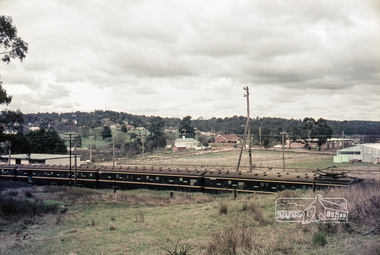 Eltham District Historical Society Inc
Photograph, Russell Yeoman, Looking south from Swan Street, Eltham, c,1965, 1965c
Train in foreground, Bridge street running parallel to train in background and Brisbane Street obscured by train. Susan Street north of Bridge Street (now Brisbane Street) on left. Vacant block of land is now the site of Bunnings. Presnt day SES building at corner of Susan and Bridge Street can be seen in centre background.The factory in lower left on Brisbane Street is the Sibbel Builders factory of Martin and Herman Sibbel who were ahead of their time with design and prefabricated frames and also built cabinetry in this factory.Digital file only; created from original colour positive slide transparencyeltham, streets, susan street, bridge street, brisbane street, train, bunnings, ses, state emergency service, sibbel builders, martin sibbel, herman sibbel -
 Marysville & District Historical Society
Postcard (Item) - Colour postcard, Neil Cutts, Marysville Victoria-Murchison Street, Unknown
A postcard in a series produced by the Rose Stereograph Company in Victoria, Australia as a souvenir of Marysville.A colour photograph of Murchison Street in Marysville, Victoria. Murchison Street is the main street of Marysville. The Rose Series postcard No. 3524.POST CARD The "Rose" Series/ De Luxe Proudly Printed in/ Australia Since 1880 AFFIX/ STAMP/ HERE/ Rose Series/ Post Card No./ 3524 ADDRESS/ POSTCODE Murchison Street/ MARYSVILLE, VICTORIA, AUSTRALIA/ Photo Neil Cutts Copyright Rose Stereograph Co., Glen Waverley, Victoria (03) 9560 7772marysville, victoria, murchison street, main street, postcard, souvenir, rose stereograph co, 3524 -
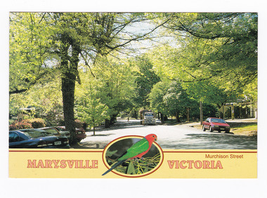 Marysville & District Historical Society
Postcard (item) - Colour postcard, Neil Cutts, Marysville Victoria-Murchison Street, Unknown
A postcard in a series produced by the Rose Stereograph Company in Victoria, Australia as a souvenir of Marysville.A colour photograph of Murchison Street in Marysville, Victoria. Murchison Street is the main street of Marysville. The Rose Series postcard No. 3524.POST CARD The "Rose" Series/ De Luxe Proudly Printed in/ Australia Since 1880 AFFIX/ STAMP/ HERE/ Rose Series/ Post Card No./ 3524 ADDRESS/ POSTCODE Murchison Street/ MARYSVILLE, VICTORIA, AUSTRALIA/ Photo Neil Cutts Copyright Rose Stereograph Co., Glen Waverley, Victoria (03) 9560 7772marysville, victoria, murchison street, main street, postcard, souvenir, rose stereograph co, 3524 -
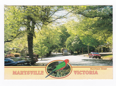 Marysville & District Historical Society
Postcard (item) - Colour postcard, Neil Cutts, Marysville Victoria-Murchison Street, Pre 2009
A postcard in a series produced by the Rose Stereograph Company in Victoria, Australia as a souvenir of Marysville.A colour photograph of Murchison Street in Marysville, Victoria. Murchison Street is the main street in Marysville. The Rose Series postcard No. 3524.POST CARD The "Rose" Series/ De Luxe Proudly Printed in/ Australia Since 1880 AFFIX/ STAMP/ HERE/ Rose Series/ Post Card No./ 3524 ADDRESS/ POSTCODE Murchison Street/ MARYSVILLE, VICTORIA, AUSTRALIA/ Photo Neil Cutts Copyright Rose Stereograph Co., Glen Waverley, Victoria (03) 9560 7772marysville, victoria, murchison street, main street, postcard, souvenir, rose stereograph co, 3524 -
 Stawell Historical Society Inc
Photograph, Gold Reef Mall -- Main Street Stawell 2003
Gold Reef Mall Main Street 2003Colour Photograph: Looking East after the removal of the mall, from the Wimmera Street Intersection.stawell business -
 Melbourne Tram Museum
Pamphlet, Yarra Trams, "Tram Improvement work - Power Street and Burwood Road Hawthorn", Jun. 2015
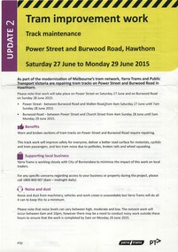
Pamphlet, A4, full colour printed on gloss paper titled "Tram Improvement work - Power Street and Burwood Road Hawthorn" - Saturday 27 June to Monday 29 June 2015/ Gives notes on works, impacts to services and a map along with contact details. 2nd update.trams, tramways, trackwork, power st, burwood rd -
 Melbourne Tram Museum
Artwork, other, Swanston Street Melbourne 1863
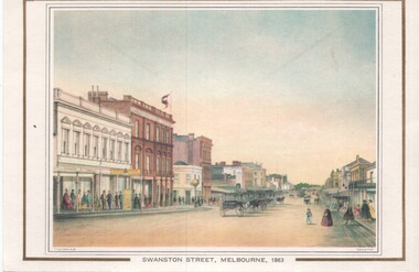
Colour print of a reproduction of an oil painting - Swanston Street from a point north of Little Bourke St looking south towards the Kings Domain. Reproduced by Kew Cottages and St Nicholas Parent's Association from a original print and lithographed by F Cogne, printed and published by Charles Troedel in his Melbourne Album 1863. Appears to have a number of horse drawn cabs parked in the centre of the street.Yields information about early Melbourne after the start of the gold rush.Reproduction of an oil painting - card - Swanston Street Melbourne 1863melbourne, horse drawn vehicles, swanston st -
 Ballarat Heritage Services
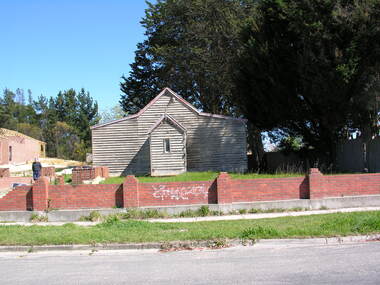
Photograph - church, Former Joseph Street Paton Memorial Presbyterian Church, Canadian, 2008, 26 /04/2008
The Jubilee of this church was held in 1933. "Paton Memorial Presbyterian Church. BALLARAT, Sunday Jubilee celebrations of the Paton Memorial Presbyterian Church were well attended in the week end. A basket picnic on Saturday at Eureka Stockade reserve was followed at night by a social gathering, at which a birthday cake was cut by Mrs. Amor, a foundation member. On Sunday special services were led by Rev. J. A. Moscript, assisted by the young men of St. John's Church. The church was originally founded, by the late Mrs. J. P. Murray to mission to the needs of the busy mining community which existed in Canadian in early years." (The Age, 06 November 1933.) PATON MEMORIAL CHURCH - An interesting tree-planting ceremony was performed in the grounds of the Paton Memorial Church on Saturday lost. Trees were put in by the scholars of the Sunday school to commemorate the enlistment of all the boys who had in any way been connected with the church. Sunday school, and Young Men's Club. The Mayor (Cr Levy) spoke in terms of praise of the lads who had enlisted to fight for right against might and the tyranny of Prussian militarism. The Hon. R. McGregor MLA., and the Revs. A. H. Moore and W. Rowlands were among those present. on also Mesdames J. P. Murray and McGowan, two of the founders of the church. During the afternoon Cr Levy planted a tree in honor of Mrs Murray. Afternoon tea was served by the ladies of the congregation. (The Age, 06 November 1933.) This church was in the middle of a Chinese neighbourhood, and the 1800s the leprosarium was in the vicinity. This bhurch was demolished not long after this photo was taken. Colour photograph of a weatherboard church in Joseph Street, Canadian. In 1937 this church was under the control of St. John's Peel-street, Ballarat. Members of the congregation: * Mrs. Amor - A foundation member. * Thomas Clarke and Isabella Clarke (formerly Ross) lived next door and according to family members "had a lot to do with the church". * Mrs McGowan - a founder of the church * Mrs. J. P. Murray founded the church to mission to the needs of the busy mining community which existed in Canadian in early years. joseph street ballarat, joseph street canadian, former joseph street paton memorial presbyterian church, ballarat, church, weatherboard church, presbyterian church, paton memorial church, clayton hill, claytons hill, leprosarium, chinese -
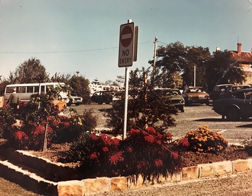 Stawell Historical Society Inc
Photograph, Car Park in Sloane Street looking towards Main Street Stawell c 1978 - Large coloured photograph
Colour photograph of Car Park Sloane Street looking towards Main Street Stawell. The car park was created when Main St. Stawell became a Pedestrian Mall c 1978Large coloured photograph taken from Sloane Street, looking towards Main St. The photo has a bus on the left hand side and cars in the car park. The photo is taken in front of a garden bed with a No Entry sign in the middle of the photograph.stawell -
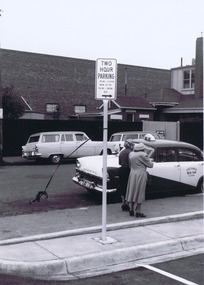 St Kilda Historical Society
Photograph, Camden Street carpark, Balaclava, 11/1962
Opening of carpark Camden Street Balaclava black and white photograph, unmounted, original, good conditionOn back: Car Park opening Camden Street Nov 1962 From Leete Chemist