Showing 8333 items matching "bridging"
-
 Monbulk Historical Society
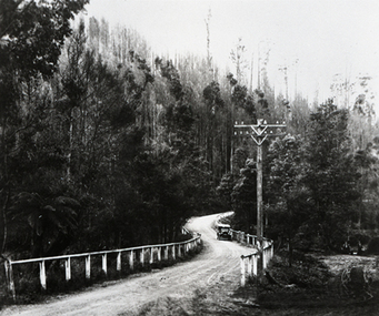
Concrete Bridge
Concrete Bridge at Monbulk C1920sconcrete bridge, 1920s, monbulk -
 Melton City Libraries
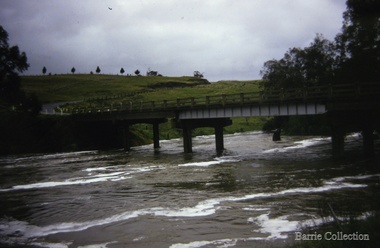
Photograph, Melton Weir, 1970
Spillway, bridge and river in flood.misc. -
 Bendigo Historical Society Inc.
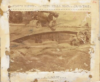
Photograph - KING'S BRIDGE STEAM ROLLER ACCIDENT, approx. 1901
Sepia print on cardboard. Printed across top : 'Kings Bridge, White Hills Road, 14.5.1901.' Image shows steam roller perched precariously on top of bridge, two wheels hanging over edge. Overturned steam roller in creek. 'Kings Bridge, White Hills Road, 14.5.1901. On bottom of photo surround: A.E. Boldt. This bridge was one of the Monier bridges built in Bendigo.bridge, construction, white hills -
 Orbost & District Historical Society
black and white photograph, C1890
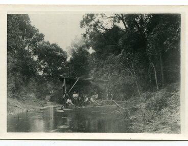
This snagging team is on the Brodribb River, east of Orbost. The Brodribb bridge can be seen in the background of the Photograph. The Snowy River was used for commercial navigation after 1880 and extensive de-snagging A shipping company was formed in 1880, poling barges upstream until the removal of large trees and branches that had fallen into the river was carried out to make the river upstream of Marlo easier to navigate. "The snaggers played an important part in making the river free for transport. By 1880 Captain Collins, R McNair engineer, J McNair and the two Winchesters were at work with a punt on the Snowy and Brodribb. Mr. Jim Winchester took charge soon after. Early snaggers were Johnston, J Renton, Nat Lynch, John Drew, Hatton, J Scott and Harry Wilkinson. The system used was to use a tree on the river bank as a lever and with heavy manila ropes, slowly to haul the snags out. They were piled up around a tree and burned when dry. The snaggers lived in a row of cottages in Snaggers’ Lane." (info. John Phillips Newsletter March 2004)The snaggers played an important role in the early settlement of the Orbost / Marlo district helping bto open it up to commercial shipping.Two copies of a black / white photograph of nine men on a snagging boat, a flat-bottom barge. In the background is a bridge.on back - "Snagging boat on Brodribb with R.McNair"snaggers-brodribb-river snagging-east-gippsland transportation -
 Glenelg Shire Council Cultural Collection
Photograph - Photograph - Bridge, n.d
Sourced from Casterton Town Hall (former Shire of Glenelg)Coloured photograph. Same as 7302 7302 - Coloured photograph. Unmade road between paddocks. Photo taken close to bridge with wooden railings. Erosion of creek sides can be seen. Sign at bridge ' Bridge Load Limit 5 t gross'? Same bridge as 7301, taken at different time. -
 Lara RSL Sub Branch
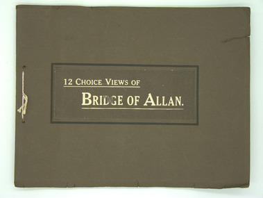
Booklet, Bridge of Allan, Circa 1960
Returned by J.W.McIntyre after WW1. Rectangular shaped Booklet. Coffee Brown in colour with two holes punched in it along the spine with a white cord tied through the holes.12 Choice Views of Bridge of Allan. -
 Bendigo Historical Society Inc.
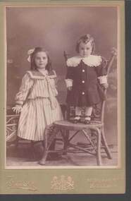
Photograph - PORTRAIT OF TWO CHILDREN
Sepia photograph of two children. Photo on green mount board. The older girl is standing and the smaller child is standing on a chair. Both have wide collars on their dresses.Fraser, 30 Bridge St. Ballaratphotograph, portrait, female group, portrait of two children, fraser ballarat -
 Kew Historical Society Inc
Photograph, Willsmere Bridge, 1934
Several boathouses were built in Kew and Fairfield in the late 19th and early 20th centuries. They included Chipperfield’s ‘Moorings’ and floating pontoon. The substantial two-storey house was named the Moorings, and incorporated an upper storey residence. The Moorings was almost washed away in the 1916 floods, and in 1934 almost totally submerged when the Yarra River rose 26 feet in 14 hours. Following the 1934 flood, the house was restored. The floating pontoon, sometimes referred to as a ‘kiosk’ or ‘canteen’, was used to store canoes. Both were removed in 1972 for the construction of the Eastern Freeway.This work forms part of the collection assembled by the historian Dorothy Rogers, that was donated to the Kew Historical Society by her son John Rogers in 2015. The manuscripts, photographs, maps, and documents were sourced by her from both family and local collections or produced as references for her print publications. Many were directly used by Rogers in writing ‘Lovely Old Homes of Kew’ (1961) and 'A History of Kew' (1973), or the numerous articles on local history that she produced for suburban newspapers. Most of the photographs in the collection include detailed annotations in her hand. The Rogers Collection provides a comprehensive insight into the working habits of a historian in the 1960s and 1970s. Together it forms the largest privately-donated collection within the archives of the Kew Historical Society.A view of flooded areas in North Kew in the flood of 1934.Willsmere Bridge. Chipperfields. 1934 floodwillsmere, flood, yarra flood, chipperfields, chipperfields boathouse, north kew -
![Photograph - Construction of the F19 [Eastern Freeway], Ron Setford, May 1976](/media/collectors/550653872162f11fb04854aa/items/6815adc98b33318343788a83/item-media/6815adff8b33318343788c4d/item-fit-380x285.jpg) Kew Historical Society Inc
Kew Historical Society IncPhotograph - Construction of the F19 [Eastern Freeway], Ron Setford, May 1976
Ron Setford and his wife Grace Setford lived in Tanner Avenue, East Kew, from c.1946 to c.1995. A keen photographer, he recorded the changing face of Kew over a 20 year period. Apart from 30 photographs of built structures and places in Kew dating from 1960 and 1961, 145 of his 35mm colour slides chronicle the development of the F19 (later renamed Eastern) Freeway through the Yarra Valley in Kew over a five year period from c.1972 to c.1977. This important collection was donated to the Society by his granddaughter in 2025.This collection of 175 35mm slides is of local and statewide significance, owing to its subject matter, particularly the major development of road transport infrastructure during the 1970s with the construction of the Eastern Freeway. The photographer also took care to annotate and date most of his slides which enable the researcher to pinpoint temporal and spatial locations."Pile driving Kew - Fairfield bridges"ron setford, eastern freeway, f19 freeway -
![Photograph - Construction of the F19 [Eastern Freeway], Ron Setford, May 1976](/media/collectors/550653872162f11fb04854aa/items/682878fc64071e7c58e658f2/item-media/6828791e64071e7c58e65aa1/item-fit-380x285.jpg) Kew Historical Society Inc
Kew Historical Society IncPhotograph - Construction of the F19 [Eastern Freeway], Ron Setford, May 1976
Ron Setford and his wife Grace Setford lived in Tanner Avenue, East Kew, from c.1946 to c.1995. A keen photographer, he recorded the changing face of Kew over a 20 year period. Apart from 30 photographs of built structures and places in Kew dating from 1960 and 1961, 145 of his 35mm colour slides chronicle the development of the F19 (later renamed Eastern) Freeway through the Yarra Valley in Kew over a five year period from c.1972 to c.1977. This important collection was donated to the Society by his granddaughter in 2025.This collection of 175 35mm slides is of local and statewide significance, owing to its subject matter, particularly the major development of road transport infrastructure during the 1970s with the construction of the Eastern Freeway. The photographer also took care to annotate and date most of his slides which enable the researcher to pinpoint temporal and spatial locations."Construction main Chandler Hwy Bridge"ron setford, eastern freeway, f19 freeway -
![Photograph - Construction of the F19 [Eastern Freeway], Ron Setford, December 1977](/media/collectors/550653872162f11fb04854aa/items/683bd7b769688f11138e7f2c/item-media/683bd7da69688f11138e80fc/item-fit-380x285.jpg) Kew Historical Society Inc
Kew Historical Society IncPhotograph - Construction of the F19 [Eastern Freeway], Ron Setford, December 1977
Ron Setford and his wife Grace Setford lived in Tanner Avenue, East Kew, from c.1946 to c.1995. A keen photographer, he recorded the changing face of Kew over a 20 year period. Apart from 30 photographs of built structures and places in Kew dating from 1960 and 1961, 145 of his 35mm colour slides chronicle the development of the F19 (later renamed Eastern) Freeway through the Yarra Valley in Kew over a five year period from c.1972 to c.1977. This important collection was donated to the Society by his granddaughter in 2025.This collection of 175 35mm slides is of local and statewide significance, owing to its subject matter, particularly the major development of road transport infrastructure during the 1970s with the construction of the Eastern Freeway. The photographer also took care to annotate and date most of his slides which enable the researcher to pinpoint temporal and spatial locations."Fairfield River Bridges towards city"ron setford, eastern freeway, f19 freeway -
![Photograph - Construction of the F19 [Eastern Freeway], Ron Setford, October 1976](/media/collectors/550653872162f11fb04854aa/items/682b0049b92b884efed27059/item-media/682b01a4b92b884efed277b0/item-fit-380x285.jpg) Kew Historical Society Inc
Kew Historical Society IncPhotograph - Construction of the F19 [Eastern Freeway], Ron Setford, October 1976
Ron Setford and his wife Grace Setford lived in Tanner Avenue, East Kew, from c.1946 to c.1995. A keen photographer, he recorded the changing face of Kew over a 20 year period. Apart from 30 photographs of built structures and places in Kew dating from 1960 and 1961, 145 of his 35mm colour slides chronicle the development of the F19 (later renamed Eastern) Freeway through the Yarra Valley in Kew over a five year period from c.1972 to c.1977. This important collection was donated to the Society by his granddaughter in 2025.This collection of 175 35mm slides is of local and statewide significance, owing to its subject matter, particularly the major development of road transport infrastructure during the 1970s with the construction of the Eastern Freeway. The photographer also took care to annotate and date most of his slides which enable the researcher to pinpoint temporal and spatial locations."New Chandler H/way bridge"ron setford, eastern freeway, f19 freeway -
 Phillip Island and District Historical Society Inc.
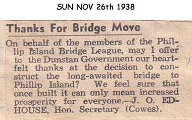
Newspaper clippings, 1938
Letter to newspaperLetter to The Sun newspaper expressing the thanks of the Phillip Island Bridge League to the Government at the decision to build a bridge to Phillip Island.local history, documents, newspapers, bridges, phillip island, black & white newspaper clipping, j edhouse -
Glenelg Shire Council Cultural Collection
Photograph - Photograph - Bridge Construction, n.d
Port of Portland Authority ArchivesFront: Back- Purple CSIRO Stampport of portland archives -
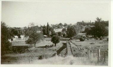
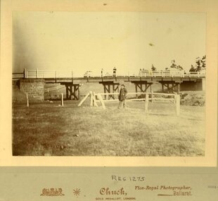 Clunes Museum
Photograph, CHUCK - GOLD MEDALLIST, LONDON. VICE REGAL PHOTOGRAPHER BALLARAT
ORIGINAL PHOTOGRAPH OF WOODEN BRIDGE WITH BLUESTONE BUTTRESS. MAN STANDING ON BRIDGE - ALSO MAN STANDING ON GRASS VERGE BY CREEK.local history, photography, photographs, bridges -
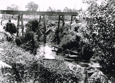 Otway Districts Historical Society
Photograph, Knox Collection, Railway Bridge over Gellibrand River, 1902
Railway bridge over the Gellibrand River, 1902. Note the people on the roadway bridge in the top left corner. B/W.colac; beech forest; gellibrand; railway; -
Stawell Historical Society Inc
Painting, Will Rees, Fyans Creek Halls Gap Vic, 1931
Framed Water Colour painting of creek with walking bridge over it and woman standing on bridge. Gum tree to left of painting.Fyans Creek Halls Gap Vic Will Rees "31 (Bruce Morcom 12-9-1987) -
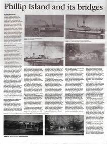 Phillip Island and District Historical Society Inc.
Newspaper Articles, Western Port News, Phillip Island and its Bridges, 23/12/2014
As per Physical Description aboveNewspaper article about Phillip Island and its bridges. Photos of 3 ferries, driving of the 1st pile for the bridge. Article about the two bridges. Photos of the Isle of Wight Hotel, The Continental Guesthouse and Erehwon Guesthouse, the first bridge - Suspension Bridge opened in 1940, Richard Grayden and Councilor Rupert Harris, Charles and Margaret Grayden with Archbishop Clarke in 1904 and a photo of 5 people at Easter in Cowes in 1911. phillip island suspension bridge, phillip island second bridge, ss genista, ss killara, ss alvina, the isle of wight hotel cowes phillip island, the continental guesthouse, erehwon guest house cowes, richard grayden, rupert harris, charles & margaret grayden, archbishop clarke, i. j. o'donnell, t. h. russell, peter mccullough -
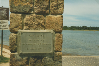 Lakes Entrance Historical Society
Photograph - Plaque on footbridge Lakes Entrance Victoria, Bessie Larkins, 1985
plaque at Northern end of the footbridge noting the date of opening by Hon. AE Lind MLA. View across Cunninghame Arm to timbered area at hummocks Lakes Entrance Victoria. Plus a second photo from the foot bridge looking east toward the rotundaColour photograph of plaque at Northern end of the footbridge noting the date of opening by Hon. AE Lind MLA. View across Cunninghame Arm to timbered area at hummocks Lakes Entrance Victoria. Plus a second photo from the foot bridge looking east toward the rotundabridges, waterways, gippsland lakes -
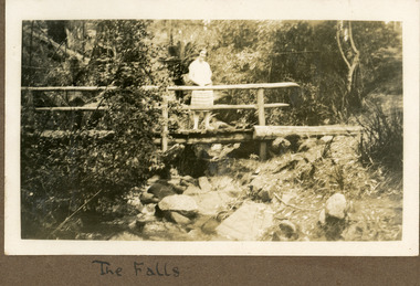 Mt Dandenong & District Historical Society Inc.
Photograph
The photograph is from the album of Ivy Child. The young woman standing on the bridge is Ivy Child probably aged 17 years. The location is the Olinda Falls. Ivy May Child (1910 – 1989) was the daughter of Arthur Edward (Ted) Child (1878 – 1964) and Ethel May Madden (1888 – 1970). Ted Child was the son of Matthew Francis Child (1839 – 1933) and Martha Jeeves (1857 – 1926). He was the grandson of one of the early pioneers Francis Child. Ivy grew up on the family property on Childs Road and took many photographs. Most of these are glued into her photo album. The album covered the years from c1927 – 1932. Ivy married Henry William Burgess (1906 – 1968) in 1944. The photographs remain in their original state in the album with individual copies made. Black and white photograph showing a young woman standing on a wooden bridge with a handrail above a creek. Rocks are in the foreground in the creek and bush surrounds the scene.Handwritten below the photograph in the album: The Fallsivy child, olinda falls, bridge -
Glenelg Shire Council Cultural Collection
Photograph - Reproduction Photograph - Bridgewater Lakes, 1920s
Black and white photograph (reproduction). Groups of men and ladies at Bridgewater Lakes, one group walking over a bridge made of sticks, one group either side of bridge, two ladies sitting on hillside above the bridgeFront: 'BRIDGEWATER LAKES' - bottom right Back: '848' in pencil -
Glenelg Shire Council Cultural Collection
Negative - Negative - Bush tracks Wooden Bridge Nelson, Victoria, c. 1936
Transparency for black and white photo. Bush tracks at Nelson, Vic, wooden bridge, scrub either side, small boy on bridge. -
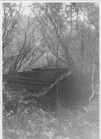 Halls Gap & Grampians Historical Society
Photograph - B/W
Photo shows old rail bridge, surrounded by bush & passing over what appears to be a creek. Bridge is supported by wooden trestles. structures, bridges -
 Whitehorse Historical Society Inc.
Photograph, Deep Creek Road Bridge, 18/04/2001 12:00:00 AM
Coloured photograph looking East from Deep Creek Road Bridge at start of construction of new Deep Creek Road Bridge.deep creek road, mitcham, vicroads -
 Phillip Island and District Historical Society Inc.
Photographs, c 1940
Six coloured photographs from a collection donated by Julie Barnett. Photos taken and purchased on her In-law's honeymoon during November 1946.Six coloured photographs as follows: 01. The Nobbies, Phillip Island 02. Cowes foreshore with Pier and Ferry. 03. Suspension Bridge 04. Cowes Pier looking towards Jetty Shed and Isle of Wight Hotel 05. Cowes Cenotaph with pier, Jetty shed and ferry in background. 06. Cowes Pier at sunset.On back: 01. The Nobbies, Phillip Island 02. Pier and Ferry Boat, at Cowes 03. San Remo Bridge, Phillip Island 04. The Pier at Cowes 05. Memorial and Pier at Cowes 06. Sunset over the Pier, Cowesthe nobbies phillip island, cowes pier phillip island, suspension bridge phillip island, cenotaph cowes phillip island, julie barnett -
Phillip Island and District Historical Society Inc.
Photograph, 1900's
This postcard is contained in an album presented to the then Governor of Victoria, The Earl of Stradbroke, by the fathers of soldiers & returned soldiers of Phillip Island, on 16/02/1923. The history of the album is noted on Reg. No 85-00Postcard of woman on bridge, Lovers' WalkThe Rose Series P653. The Lovers' Walk, Phillip Island, Victorialocal history, photography, photographs, slides, film, lovers' walk, cowes, phillip island, sepia photograph -
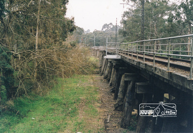 Eltham District Historical Society Inc
Photograph, Trestle Bridge, Eltham
Colour photograph of the Eltham trestle bridgeeltham, trestle bridge, bridges -
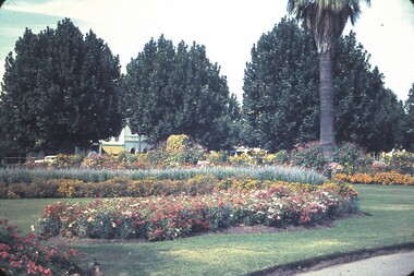 Bendigo Historical Society Inc.
Slide - BENDIGO & EASTER FAIR, 1963
Bendigo Conservatory Gardens, Bridge Street.slide, bendigo, conservatory gardens -
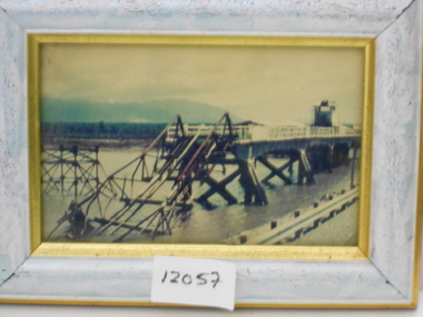 National Vietnam Veterans Museum (NVVM)
Photograph, Damaged Bridge
Framed coloured photo of a damaged bridgephotograph, bridge -
 Clunes Museum
Photograph
VIEW OF SUSPENSION BRIDGE WITH TOWNSHIP IN THE DISTANCEsuspension bridge, local history