Showing 33220 items matching "buildings/streetscapes"
-
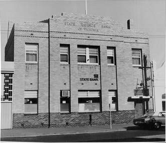 Port Melbourne Historical & Preservation Society
Photograph - SSB building 1980 with car outside, Public Records Office Victoria (PROV), 1886 - 1982
The State Savings Bank building was constructed c1891. Remodeled in 1940sCOPYRIGHT Public records Office Victoria .10 - 1980 building with car built environment - commercial, business and traders, transport - motor vehicles, state savings bank of victoria -
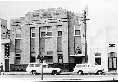 Port Melbourne Historical & Preservation Society
Photograph - SSB building 1978, Public Records Office Victoria (PROV), 1886 - 1982
The State Savings Bank building was constructed c1891. Remodeled in the 1940sCOPYRIGHT Public records Office Victoria .09 - 1978 building with cars built environment - commercial, business and traders, transport - motor vehicles, state savings bank of victoria -
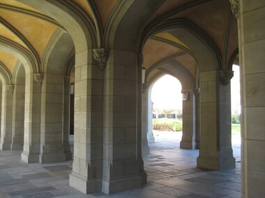 Victorian Interpretive Projects Inc.
Photograph - Colour, Clare Gervasoni, Old Quadrangle, Melbourne University, 02/10/2010
It was during the construction of this building that stonemasons put down their tools in April 1856 and marched to the City of Melbourne and inaugurated a movement which won the Eight Hours Day for building workers in Victoria. The victory became an international benchmark in the history of the labour movement. This is the oldest building on campus and was constructed of Tasmanian freestone between 1854 and 1857 to the design of architect Francis M. White. For many years the building was used as the University's Administrative centre, library, lecture rooms and professional residences. The east and west wings were extended in 1930 to the design of J.S. Gawler. The quadrangle was completed in 1969 with the addition of the southern wing which contains the University Council Chamber designed by R.E. Featherstone.Colour photograph in digital format of the arches of a sandstone building at Melbourne University.university of melbourne, eight hours day, eight hour day, 8 hour day, gawler, featherstone, fm white, tasmanian sandstone, sandstone, francis white -
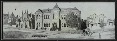 Federation University Historical Collection
Photograph - Photograph - black and white, Ballarat School of Mines, Lydiard Street, Ballarat, c1909, c1909
Ballarat School of Mines was established in 1870 making it Australia's first School of Mines. It is now Federation University Australia SMB Campus.Ballarat School of Mines from Lydiard Street. The former Wesley Church is on the left of the photo. Beside it is the New Classrooms (now Administration Building), and the former Ballarat Circuit Court which was demolished in 1912 and replaced the the Ballarat Technical Art School building. .1) Sepia print .2) Black and white print showing all the Lydiard Street streetscape with people in the doorway and a horse and buggy in the street. .3) Black and white copy .4) Line drawing taken from the photo.ballarat school of mines, lydiard street, ballarat, administration buildings, former circuit court, former wesley church, administration building, a building, former methodist church -
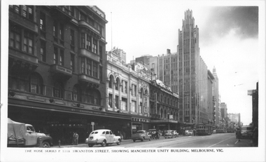 Melbourne Tram Museum
Postcard, Rose Stereograph Co, "Swanston Street, showing Manchester Unity Building, Melbourne", late 1940s
Rose Series postcard No. P 1718, titled "Swanston Street, showing Manchester Unity Building, Melbourne", Photo looking north along Swanston Street from Flinders Lane. Has a one W2 class, one W5 class and one W4 class tramcar in view. The Manchester Unity Building, Capital Theater and the Century Building all dominate the streetscape between Collins and Little Collins Streets. The Champion Building on left of the photo was built around 1923 and demolished around 1972. Yields information about an aerial view of Melbourne late 1930sPostcard - printed real photograph with Rose Stereograph Co. name on the rear.tramways, trams, swanston st, manchester unity building, w2 class, w5 class, w4 class -
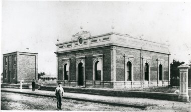
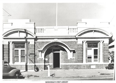 Wodonga & District Historical Society Inc
Photograph - Original Wodonga Library
W. Thorne architect of Albury designed the library building and the plan was approved in June 1915 The building contractor was J. W. Cochrane of Albury. The land was purchased from Mr. Walter Huon. On the 28th July 1915 the Shire President, Councillor Beardmore, laid the foundation stone for the building that would become the Wodonga Public Library. Almost 12 months later, on the 8th March 1916, the library was officially opened. It was the pride of Wodonga. The Shire Council closed their doors for a brief period so that all staff could attend the opening and the teachers and children of the local schools also attended. Councillor Beardmore declared that “it was an asset that would return a profit- not in pounds and shillings and pence but in the development and furnishing of the minds and lives of our young people”. It was known as the Beardmore Library. The Wodonga Athenaeum, in an out of the way location, had closed in 1914 after continuing reports of a lack of funds and the proceeds of the sale of the building went towards the building of the new library. In 1915 the library building committee started to put together a building fund for a new library. The library, situated at 78 High Street, was funded almost exclusively by the public. The books from the Athenaeum were presented to the library committee at the opening in 1916. The new library was both a place for education and recreation, a communal space to socialise, which also boasted a billiards room downstairs. In March 1970 construction of a new Civic Centre which included a library began in Wodonga. With its completion the following year, the original library was closed down. The building was vacant for some time and deteriorated badly. It was later purchased by Peter Middleton, who extensively restored the building. These images have local significance as they document an important building in Wodonga.2 photos - one black and white and one in colour of the same brick building. The first photo is of the building when it served as the Wodonga Public Library. The colour photo was taken approximately 60 years later.Photo 1 - In Brickwork above the door: PUBLIC LIBRARY Photo 2 - Above door: MIDDLETONS CARPETSwodonga public library, wodonga buildings -
 Stawell Historical Society Inc
Photograph, Stawell Shire Hall 1866
This photograph is a copy obtained from State Library of Victoria. The photograph is of Stawell Shire Hall. Two persons can be seen in the foreground. The two story brick building beside the Stawell Shire Hall was once the Literary Institute. The Stawell Shire Hall building has been added to over the years. Ronald Campbell, the Shires second president laid the foundation stone on 28th April. 1866. The contractors were Hutchings and Delbridge. The photograph shows the first hall and office. The building contained simple 18 feet square rooms, with an entrance hall separating them, the facade was almost as it is now. The initial cost of the Shire Hall was $502.Black and white photograph of Stawell Shire Hall as one single storey brick building with parapet on top. Beside the Shire Hall is a two storey brick building. Also, a dwelling between the two building in the background in Cooper St. Two persons in the foreground, one on the road the other on the pathway. stawell -
 Kew Historical Society Inc
Plan, Melbourne and Metropolitan Board of Works, Borough of Kew : Detail Plan No.1580, 1904
The Melbourne and Metropolitan Board of Works (MMBW) plans were produced from the 1890s to the 1950s. They were crucial to the design and development of Melbourne's sewerage and drainage system. The plans, at a scale of 40 feet to 1 inch (1:480), provide a detailed historical record of Melbourne streetscapes and environmental features. Each plan covers one or two street blocks (roughly six streets), showing details of buildings, including garden layouts and ownership boundaries, and features such as laneways, drains, bridges, parks, municipal boundaries and other prominent landmarks as they existed at the time each plan was produced. (Source: State Library of Victoria)This plan forms part of a large group of MMBW plans and maps that was donated to the Society by the Mr Poulter, City Engineer of the City of Kew in 1989. Within this collection, thirty-five hand-coloured plans, backed with linen, are of statewide significance as they include annotations that provide details of construction materials used in buildings in the first decade of the 20th century as well as additional information about land ownership and usage. The copies in the Public Record Office Victoria and the State Library of Victoria are monochrome versions which do not denote building materials so that the maps in this collection are invaluable and unique tools for researchers and heritage consultants. A number of the plans are not held in the collection of the State Library of Victoria so they have the additional attribute of rarity.Original survey plan, issued by the MMBW to a contractor with responsibility for constructing sewers in the area identified on the plan within the Borough of Kew. The plan was at some stage hand-coloured, possibly by the contractor, but more likely by officers working in the Engineering Department of the Borough and later Town, then City of Kew. The hand-coloured sections of buildings on the plan were used to denote masonry or brick constructions (pink), weatherboard constructions (yellow), and public buildings (grey). The area represented in this detail plan has undergone significant change during the 20th century. The widening of High Street in the 1930s and 1950s involved the shops on the south side of High Street being demolished and later rebuilt to fit the widened street. Another significant loss was the mansion ‘Drayton’ fronting Wellington Street, owned at this stage by Susannah Fenton. Her family name would later to be given to Fenton Way, which was to be built over the grounds of the house following its demolition. The plan of the garden is particularly interesting, containing a batten dome fronting Wellington Street, an ornamental pond, a fountain and a brick and glass conservatory. The notes by the plumbing contractor on this plan are particularly detailed. Pink borders delineate the ownership of the varying parcels of land. Some of the better known owners listed include the real estate agent Cr. Henry de Castres Kellett (bt) and John Padbury, the funeral director. This particular plan provides a clear view of the configuration of the Kew Junction in 1903 and the commercial buildings that surrounded it.melbourne and metropolitan board of works, detail plans, maps - borough of kew, mmbw 1580, cartography -
 Kew Historical Society Inc
Plan, Melbourne & Metropolitan Board of Works : Borough of Kew : Detail Plan No.1585, 1904
The Melbourne and Metropolitan Board of Works (MMBW) plans were produced from the 1890s to the 1950s. They were crucial to the design and development of Melbourne's sewerage and drainage system. The plans, at a scale of 40 feet to 1 inch (1:480), provide a detailed historical record of Melbourne streetscapes and environmental features. Each plan covers one or two street blocks (roughly six streets), showing details of buildings, including garden layouts and ownership boundaries, and features such as laneways, drains, bridges, parks, municipal boundaries and other prominent landmarks as they existed at the time each plan was produced. (Source: State Library of Victoria)This plan forms part of a large group of MMBW plans and maps that was donated to the Society by the Mr Poulter, City Engineer of the City of Kew in 1989. Within this collection, thirty-five hand-coloured plans, backed with linen, are of statewide significance as they include annotations that provide details of construction materials used in buildings in the first decade of the 20th century as well as additional information about land ownership and usage. The copies in the Public Record Office Victoria and the State Library of Victoria are monochrome versions which do not denote building materials so that the maps in this collection are invaluable and unique tools for researchers and heritage consultants. A number of the plans are not held in the collection of the State Library of Victoria so they have the additional attribute of rarity.Original survey plan, issued by the MMBW to a contractor with responsibility for constructing sewers in the area identified on the plan within the Borough of Kew. The plan was at some stage hand-coloured, possibly by the contractor, but more likely by officers working in the Engineering Department of the Borough and later Town, then City of Kew. The hand-coloured sections of buildings on the plan were used to denote masonry or brick constructions (pink), weatherboard constructions (yellow), and public buildings (grey). This plan, which covers parts of High Street, Pakington Street and Derby Street is dominated by two historic Kew mansions: ‘Konetta’ and ‘Ramornie’. Ramornie was constructed in 1890 for James Maitland Campbell, three times Mayor of Kew. Sold in 1940, it became a boarding house known as ‘The Towers’. Now a private residence again, it has only one of its three balconies remaining. The location of the missing two balconies can be seen on the plan. In 1903, the grounds of Ramornie included a large tennis court fronting Pakington Street. The rear of the property is shown as extending to Cobden Street. One of Kew’s oldest hotels, the Prospect Hill Hotel on the corner of High and Cobden Street was established in 1858. The outline of the hotel shown on the plan represents the second building on the site. During the 19th century it was often used for electoral meetings. The Prospect Hill Hotel was to be redeveloped again in 1928, by the local architect Robert McIntyre. Since the 1980s, the hotel has been a live music venue, the home of the Melbourne Jazz Club, a restaurant and a liquor outlet.melbourne and metropolitan board of works, detail plans, maps - borough of kew, mmbw 1585, cartography -
 Kew Historical Society Inc
Plan, Melbourne & Metropolitan Board of Works : Borough of Kew : Detail Plan No.1563, 1905
The Melbourne and Metropolitan Board of Works (MMBW) plans were produced from the 1890s to the 1950s. They were crucial to the design and development of Melbourne's sewerage and drainage system. The plans, at a scale of 40 feet to 1 inch (1:480), provide a detailed historical record of Melbourne streetscapes and environmental features. Each plan covers one or two street blocks (roughly six streets), showing details of buildings, including garden layouts and ownership boundaries, and features such as laneways, drains, bridges, parks, municipal boundaries and other prominent landmarks as they existed at the time each plan was produced. (Source: State Library of Victoria)This plan forms part of a large group of MMBW plans and maps that was donated to the Society by the Mr Poulter, City Engineer of the City of Kew in 1989. Within this collection, thirty-five hand-coloured plans, backed with linen, are of statewide significance as they include annotations that provide details of construction materials used in buildings in the first decade of the 20th century as well as additional information about land ownership and usage. The copies in the Public Record Office Victoria and the State Library of Victoria are monochrome versions which do not denote building materials so that the maps in this collection are invaluable and unique tools for researchers and heritage consultants. A number of the plans are not held in the collection of the State Library of Victoria so they have the additional attribute of rarity.Original survey plan, issued by the MMBW to a contractor with responsibility for constructing sewers in the area identified on the plan within the Borough of Kew. The plan was at some stage hand-coloured, possibly by the contractor, but more likely by officers working in the Engineering Department of the Borough and later Town, then City of Kew. The hand-coloured sections of buildings on the plan were used to denote masonry or brick constructions (pink), weatherboard constructions (yellow), and public buildings (grey). This plan covers the area between Barkers Road, Wrixon Street, Sackville Street and Brougham Place, much of it now occupied by Carey Baptist Grammar and Preshil schools. This was an area of large and prestigious homes in 1903, some with formally laid-out gardens, such as ‘Tower Hill’ and ‘Opawa’. ‘Kalimna’ was built in 1890-91 for William H. Jarman, an accountant, and ‘Blackhall’ at the same time for W.H. Roberts. Blackhall was to be acquired by the Salvation Army in 1915 and renamed ‘Catherine Booth Girls’ Home’. The Home accommodated girls, aged between 4 and 16. Kalimna and Blackhall are of significance as typical and intact late Victorian mansions and as such are two key Victorian buildings to have been built in Kew. Both Blackhall and Kalimna are now part of Preshil. ‘Fairview’ was for a long time occupied by the Sisters of St. Joseph of Cluny as a care home for the elderly, but it is now part of Carey Grammar School, as are the grounds of ‘Wagga Merne’, ‘Weemutta’, ‘Blakely’, ‘Daheim’ and ‘Mildura’ (later ‘Urangeline’), the last being particularly impressive in 1903, with a tennis court, conservatory, outhouses, and two bathrooms!melbourne and metropolitan board of works, detail plans, mmbw 1563, cartography -
 Kew Historical Society Inc
Plan, Melbourne & Metropolitan Board of Works : Borough of Kew : Detail Plan No.1574, 1905
The Melbourne and Metropolitan Board of Works (MMBW) plans were produced from the 1890s to the 1950s. They were crucial to the design and development of Melbourne's sewerage and drainage system. The plans, at a scale of 40 feet to 1 inch (1:480), provide a detailed historical record of Melbourne streetscapes and environmental features. Each plan covers one or two street blocks (roughly six streets), showing details of buildings, including garden layouts and ownership boundaries, and features such as laneways, drains, bridges, parks, municipal boundaries and other prominent landmarks as they existed at the time each plan was produced. (Source: State Library of Victoria)This plan forms part of a large group of MMBW plans and maps that was donated to the Society by the Mr Poulter, City Engineer of the City of Kew in 1989. Within this collection, thirty-five hand-coloured plans, backed with linen, are of statewide significance as they include annotations that provide details of construction materials used in buildings in the first decade of the 20th century as well as additional information about land ownership and usage. The copies in the Public Record Office Victoria and the State Library of Victoria are monochrome versions which do not denote building materials so that the maps in this collection are invaluable and unique tools for researchers and heritage consultants. A number of the plans are not held in the collection of the State Library of Victoria so they have the additional attribute of rarity.Original survey plan, issued by the MMBW to a contractor with responsibility for constructing sewers in the area identified on the plan within the Borough of Kew. The plan was at some stage hand-coloured, possibly by the contractor, but more likely by officers working in the Engineering Department of the Borough and later Town, then City of Kew. The hand-coloured sections of buildings on the plan were used to denote masonry or brick constructions (pink), weatherboard constructions (yellow), and public buildings (grey). This plan shows several very large houses, particularly along Glenferrie Road, and the area now occupied by Ruyton Girls’ School. ‘Tarring’ (incorrectly spelled here as ‘Karring’) was built for Henry Henty in 1872, on part of his original allotment of 20 acres, and ‘Mount View’, which retains its original building and the fountain in the front garden, is part of Ruyton’s Junior School. The most significant change to Tarring and its grounds since 1903, involve the removal of a number of the outbuildings, including a Burmese temple, bought by Henty from the Burmese Exhibit at the Great Exhibition of 1880. It is shown on the plan as a summerhouse. The two-storey mansion, on the corner of Glenferrie Road and Wellington Street, was built in 1891 by leading architect Alfred White as his own home. Having an initial N.A.V. of £160, the house was purchased by a warehouseman Henry Lister, by 1900, when the N.A.V. was recorded at £111. By the turn of the century the house was known as ‘Comaques’. By contrast, much smaller houses are shown in Scott and Byron Streets, including a tiny Mission Hall in Byron Street, which belonged to the Anglican Church from at least 1903 to 1917.melbourne and metropolitan board of works, detail plans, maps - borough of kew, mmbw 1574, cartography -
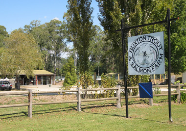 Marysville & District Historical Society
Photograph (Item) - Colour photograph, Unknown
A colour photograph of the entry and buildings at Buxton Trout & Salmon Farm in Victoria.A colour photograph of the entry and buildings at Buxton Trout & Salmon Farm in Victoria. Buxton Trout and Salmon Farm was established in 1958 and is Australia's first commercial trout farm where trout have been reared for over 50 years.buxton, victoria, buxton trout and salmon farm, advertising brochure, brochure, trout, salmon -
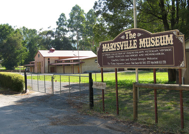 Marysville & District Historical Society
Photograph (Item) - Colour photograph, Unknown
A colour photograph of the sign and the building housing the Marysville Museum in Marysville in Victoria.A colour photograph of the sign and the building housing the Marysville Museum in Marysville in Victoria. Fred Sawyer was originally from London, but then later relocated to Sydney, Australia, and then to Marysville in Victoria where he established The Marysville Museum. The Marysville Museum held a collection of horse-drawn vehicles, veteran, vintage, and classic vehicles, various machinery, and memorabilia. the marysville museum, marysville, victoria, fred sawyer -
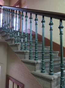 Federation University Historical Collection
Photograph - Photograph - colour, Stairway in the Ballarat School of Mines Administration Building, 2014, 08/07/2014
The Ballarat School of Mines Administration Building was formerly known as the 'New Classrooms"Two photographs of a stone staircase in the Ballarat School of Mines Administration Building.ballarat school of mines, stairs, stairwell, stairway, administration building, new classrooms, architectural features, a building -
 Clunes Museum
Photograph
... buildings ...R.S.L. BUILDING WAS ORIGINALLY BUILT AS THE LONDON CHARTERED BANK AND THEN THE E.S.& A. BANK, WHICH WAS THEN SOLD TO MR. HARRY PICKFORD, WHO THEN SOLD THE BUILDING TO THE R.S.L..1 .2 BLACK AND WHITE PHOTOGRAPH OF RETURNED SOLDIERS LEAGUE BUILDING IN FRASER STREET, CLUNES.local history, photography, photographs, buildings -
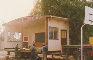 Port Melbourne Historical & Preservation Society
Photograph - Moving the Migrant Portable Building at Nott Street Primary School 1989, 1989
Building to be used for migrant education.Colour photograph of portable building in position at Nott Street Primary School, Port Melbourne1989education - primary schools, nott street primary school, migrant education -
 Ballarat Heritage Services
Photograph - Colour, Clare Gervasoni, Building Under Construction on the Australian Catholic University (Ballarat Campus), 2018, 17/11/2018
The building houses studies in Paramedicine. Two colour photographs of a building under construction on the Australian Catholic University Ballarat Campus.australian catholic university, ballarat campus, acu, building construction, physiotherapy building -
 Kew Historical Society Inc
Plan, Melbourne & Metropolitan Board of Works : Borough of Kew : Detail Plan No.1590, 1905
The Melbourne and Metropolitan Board of Works (MMBW) plans were produced from the 1890s to the 1950s. They were crucial to the design and development of Melbourne's sewerage and drainage system. The plans, at a scale of 40 feet to 1 inch (1:480), provide a detailed historical record of Melbourne streetscapes and environmental features. Each plan covers one or two street blocks (roughly six streets), showing details of buildings, including garden layouts and ownership boundaries, and features such as laneways, drains, bridges, parks, municipal boundaries and other prominent landmarks as they existed at the time each plan was produced. (Source: State Library of Victoria)This plan forms part of a large group of MMBW plans and maps that was donated to the Society by the Mr Poulter, City Engineer of the City of Kew in 1989. Within this collection, thirty-five hand-coloured plans, backed with linen, are of statewide significance as they include annotations that provide details of construction materials used in buildings in the first decade of the 20th century as well as additional information about land ownership and usage. The copies in the Public Record Office Victoria and the State Library of Victoria are monochrome versions which do not denote building materials so that the maps in this collection are invaluable and unique tools for researchers and heritage consultants. A number of the plans are not held in the collection of the State Library of Victoria so they have the additional attribute of rarity.Original survey plan, issued by the MMBW to a contractor with responsibility for constructing sewers in the area identified on the plan within the Borough of Kew. The plan was at some stage hand-coloured, possibly by the contractor, but more likely by officers working in the Engineering Department of the Borough and later Town, then City of Kew. The hand-coloured sections of buildings on the plan were used to denote masonry or brick constructions (pink), weatherboard constructions (yellow), and public buildings (grey). Surveyed by the Board of Works in 1903 and published in 1904, Plan No.1590 shows development north of Cotham Road. While this plan includes built structures in Mary Street, Cotham Road, High Street, Park Hill Road, Kent Street, Ridgeway Avenue, and Ermington Lane (now Ermington Place), only part of this section was notated and coloured in this contractor’s copy. Numerous houses, large and small are named on the plan: ‘Cholula’, ‘Belper’, ‘The Uplands’, ‘Spring Grove’ facing Cotham Road; ‘Marion’ facing Kent Street; and ‘Kia Ora’ facing Ridgeway Avenue.melbourne and metropolitan board of works, detail plans, mmbw 1590, survey plans - borough of kew, cartography -
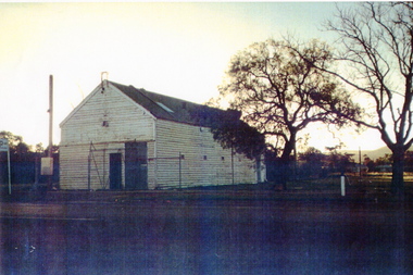 Sunbury Family History and Heritage Society Inc.
Photograph, c 1940s
The building was the former Sunbury Fire Station. It was in Evans Street on the site where the shopping square has been built. Mount Holden can be seen in the background. A newer building was built for the CFA on the opposite side of Evans Street and closer to Macedon Street. As the shopping centre expanded and Sunbury grew, the CFA moved from the town centre to a site in Jackson Street and another one in Elizabeth Drive.Over the years the CFA has played an important role in numerous fire fighting activities over summer months.A scanned coloured photograph with a fine white border of an old weatherboard building with a metal roof by an unmade roadway. A hill is in the background and two bare trees are growing near the building.sunbury cfa. -
 Federation University Historical Collection
Photograph - Black and White Photograph, Ballarat School of Mines Bricklaying, 11/1989
A Ballarat School of Mines Bricklaying student constructs a inle brick wall as would be required for a veneer building. Photograph of Ballarat School of Mines Bricklaying, part of Building Studiesbuilding studies, ballarat school of mines, bricklaying, apprentice, alumni -
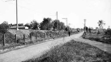 Greensborough Historical Society
Photograph - Digital Image, Somers Avenue Macleod, 1950s
Digital of streetscape, possibly Somers Avenue Macleod.Digital image of black and white photograph.somers avenue macleod -
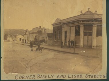 Ararat & District Historical Society (operating the Langi Morgala Museum)
Photograph
An early streetscape of Ararat's central business district.Sepia photograph of a shop on a corner. Written on the shop front is View Point Dispensary Medical Dispensary. Five young boys and a dog are standing in front of the shop while a man is seated on a horse beside a dog.Written on front" Corner of Barkly and Ligar Streets -
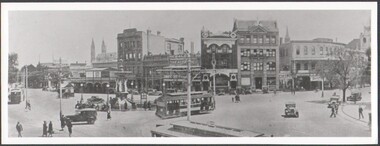 Bendigo Historical Society Inc.
Photograph - B&W photograph of the intersection of Pall Mall, View & Mitchell Streets, Bendigo, early 1900s
Early 1900s streetscape of major intersection in Bendigo Landscape format. B&W photograph of the intersection of Pall Mall, View & Mitchell Streets, Bendigo, early 1900s. Three electric trams, cars and pedestrians social history -
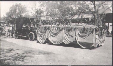 Bendigo Historical Society Inc.
Photograph - B&W photograph of a "float" for the Myer Store for the Bendigo Easter Fair
Early 1900s streetscape of major intersection in BendigoLandscape format. B&W photograph of a "float" for the Myer Store entered in the Bendigo Easter Fair, undated early 1900s photograph. Four people representing Myer on the floatsocial history -
Port Melbourne Historical & Preservation Society
Flyer - Promotional material from Mission Arts Centre, 1988
The Missions to Seamen building, designed by architect Harry Norris and built in 1937, was located on the site proposed 50 years later for development by the Sandridge Development Company. The building fell into disrepair after it was closed by the church in 1972, but enjoyed a brief and energetic period in 1987-90 when it was used as a community arts centre. These documents record the campaign waged to save the building from demolition. It was demolished in October 1995.Material relating to a campaign to save the Missions to Seamen building, 1987-88: items relating to an open day at the Missions to Seamen building for Heritage Week, 22 to 25 April 1988, including notes for accompanying guided tourmission to seamen, arts and entertainment, mission arts centre, national trust of victoria, harry a norris, pat grainger, barry merat, brian couldrey, town planning, heritage -
 Broadmeadows Historical Society & Museum
Painting - Building Painting, Jean Jackson, "Woodlands" A Renovated Building, 1985
Painting of a renovated building on the Woodlands Park.Painted by Jean JacksonOil on board painting (unframed)Label 1 on back: 'Woodlands"/A Renovated/Building/By/Jean Jackson 1985 Label 2 on back: ME-0599 In red ink: Jean 1404GGbroadmeadows, "woodlands", renovated building, painting, jean jackson -
 Rutherglen Historical Society
Image, Olive Codling
Some of the buildings of the Mount Ophir winery. Photo was taken by Miss Olive Codling, who was a life member of the Wodonga Historical Society. Photograph is believed to have been taken on the occasion of a Tour by the North East Branch, 1st combined meeting.Black and white photograph of brick buildings, one of them with a tower. To the right in the foreground is a building with a domed roof, the roof in poor repair.mt ophir, mount ophir, wine industry -
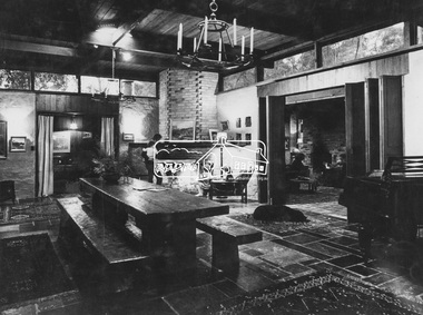
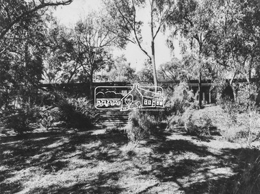 Eltham District Historical Society Inc
Photograph, Alistair and Margot Knox House
Image 18 Alistair and Margot Knox House Designed and built by the owners The Alistair Knox Collection The Alistair Knox Collection is a series of mounted enlarged photos of mud brick houses and related subjects. The collection is understood to have been put together by Alistair Knox although it is the work of several unacknowledged photographers. For some years it was held by the Building Department of the former Eltham Shire Council and was then passed to our Society for safekeeping. Some of the photos have been used in Knox's books and from time to time some of them have been part of various historical displays. As far as we know there has not been a public display of the whole collection which numbers about forty photographs. The collection has been copied on to slides for the purpose of this meeting and to be retained as part of the Society's pictorial collection. Alistair Knox 1912 - 1986 is acknowledged as the founder of Eltham's mud brick building movement. Many of the buildings shown in the collection are of his design and he was also involved with the construction of several of them. Others are the work of his contemporaries and associates such as Peter Glass, Gordon Ford, and John Harcourt. (EDHS Newsletter No. 145 July 2002)Handwritten notes in pencil re details of building, year of construction, owner, designer, builder, etcalistair and margot knox house, alistair knox, alistair knox design, houses, margot knox, mud brick construction, alistair knox collection -
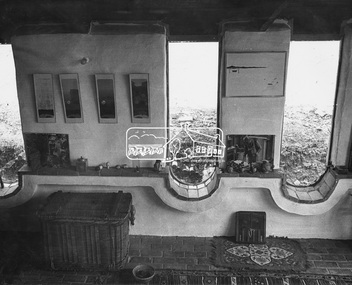 Eltham District Historical Society Inc
Photograph, Possibly Deborah Halpen / Macgregor Knox House
No image number Possibly Deborah Halpen / Macgregor Knox House The Alistair Knox Collection The Alistair Knox Collection is a series of mounted enlarged photos of mud brick houses and related subjects. The collection is understood to have been put together by Alistair Knox although it is the work of several unacknowledged photographers. For some years it was held by the Building Department of the former Eltham Shire Council and was then passed to our Society for safekeeping. Some of the photos have been used in Knox's books and from time to time some of them have been part of various historical displays. As far as we know there has not been a public display of the whole collection which numbers about forty photographs. The collection has been copied on to slides for the purpose of this meeting and to be retained as part of the Society's pictorial collection. Alistair Knox 1912 - 1986 is acknowledged as the founder of Eltham's mud brick building movement. Many of the buildings shown in the collection are of his design and he was also involved with the construction of several of them. Others are the work of his contemporaries and associates such as Peter Glass, Gordon Ford, and John Harcourt. (EDHS Newsletter No. 145 July 2002)Handwritten notes in pencil re details of building, year of construction, owner, designer, builder, etcdeborah halpen, houses, macgregor knox house, mud brick construction, alistair knox collection