Showing 1743 items matching "concrete"
-
 Ballarat Heritage Services
Photograph - digital photographs, Lisa Gervasoni, Kooweerup Pre Olympic Swimming Pool, 2010, c2010
Colour photograph of a pre Olympic Swimming Pool in Kooweerup, Victoria. swimming pool, sport, swimming, pre olympic, concrete, kooweerup, kooweerup swimming pool -
 Ballarat Heritage Services
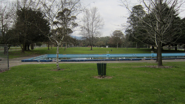
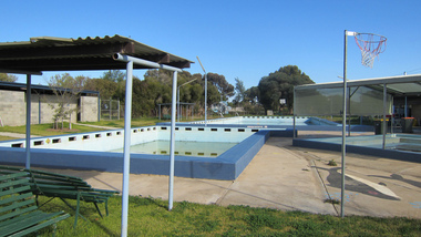
Photograph - digital photographs, Lisa Gervasoni, Healesville Pre Olympic Swimming Pool, c2015, c2010-2017
Colour photograph of the Swimming pool at Healesville, Victoria.swimming pool, sport, swimming, pre olympic, concrete, healesville, healesville swimming pool -
 Ballarat Heritage Services
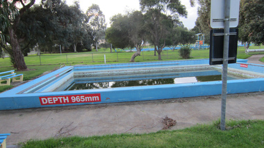
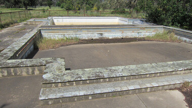
Photograph - digital photographs, Lisa Gervasoni, Buninyong Pre Olympic Swimming Pool, c2010-2017
Colour photographed of a decommissioned swimming pool at Buninyong, Victoria. swimming pool, sport, swimming, pre olympic, concrete, buninyong, buninyong swimming pool -
 Ballarat Heritage Services
digital photographs, Lisa Gervasoni, Broadford Pre Plympic Swimming Pool, c2010, c2010-2017
Colour photograph of the Swimming Pool at Broadford, Victoria. swimming pool, sport, swimming, pre olympic, concrete, broadford, broadford swimming pool -
 Ballarat Heritage Services
digital photographs, Lisa Gervasoni, Cocoroc pre olympic pool, c2010-2017
In 1892 the Melbourne and Metropolitan Board of Works established the Metropolitan Sewage Farm on the western bank of the Werribee River, to treat the effluent from Melbourne's new sewerage system.This area was isolated and too far from Melbourne, so the Cocoroc village was built to house the workers.Colour photograph of the Cocoroc Swimming Pool. This pool was built by the town's residents.swimming pool, sport, swimming, pre olympic, concrete, cocoroc, cocoroc swimming pool -
 Ballarat Heritage Services
Photograph - Swimming Pool, Lisa Gervasoni, Pyramid Hill Pre Olympic Swimming Pool, c2010-2017
Colour photograph of the Pyramid Hill Swimming Pool.swimming pool, sport, swimming, pre olympic, concrete, pyramid hill, pyrimid hill swimming pool -
 Halls Gap & Grampians Historical Society
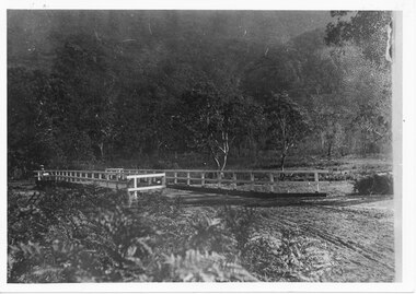
Photograph, C 1911
This is the second Delley''s Bridge. A new and more substantial bridge was built in 1911, only to be badly damaged in a 1917 flood. The collapsed western end was rebuilt, this time supported by concrete pillars.The photo shows a dirt road crossing a creek via a wooden bridge. A woman is driving a horse and buggy onto the far end of the bridge. There are ferns in the foreground and trees in the background.access routes, roads, structures, bridges -
 Melbourne Tram Museum
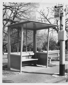
Photograph - Short modular passenger shelter on Toorak Rd
This photograph shows empty shorter version of modular passenger shelter with tram stop sign 24 route 8 in foreground, older style wooden and concrete seat adjacent, and parkland in background.Yields information about roadside facilities for travellersBlack and white photograph with texta note on rearModulartram, passenger shelter, modular, toorak rd, route 8 -
 Robin Boyd Foundation
Book, Martha Boice, The Fine Arts Cookbook II, 1981
Softcover, Spiral BoundInscription inside front cover to Patricia from Mary, dated October 1981. "A Letter from Sages Cottage" inserted inside. Newspaper cutout of a TV review "At Last - A concrete-hating architect" by Sylvia Clayton about Norman Foster Inserted insidecookery, cooking, walsh st library -
 Rutherglen Historical Society
Photograph - Image, Thalma, July 1911
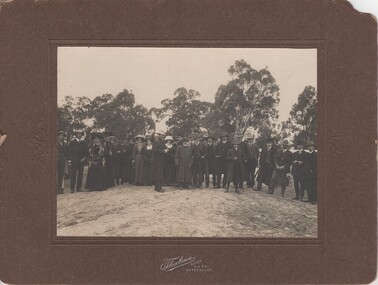
Group photograph taken on the occasion of the opening of Lilliput Bridge in July 1911. Two individuals in the photograph have been identified as Olive Hiskins and her father John Hiskins.Group photograph, mounted on brown cardboard, Photographic studio identified at bottom of cardboard frame on front. Details of event written on back.On back "Opening Lilliput Bridge in 1911". "This photo given to W.H. Pleming on 7th July '75 by Mrs Tom Franki - nee Violet Withers (Ulina)" "The Bridge was replaced by a concrete Bridge in May 1940" On front "Thalma. Ilsley Opp. P.O. Rutherglen"olive hiskins, john hiskins, lillput bridge -
 Lorne Historical Society
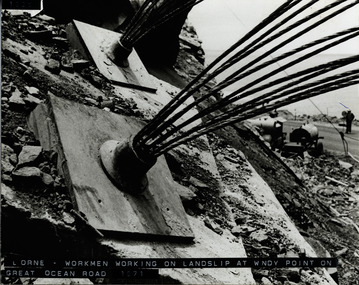
Photograph, Landslip Great Ocean Road 1971
Repairing land-slip at Windy-Point, showing cables that secured the face of the cliff. These cables ends are cut off and a concrete slab placed over the plate. Working machine below on the G.O.R. and workman holding stop/go sign.land-slip 1971: windy-point; cable-locks. concrete securing blocks. maintenance equipment -
 Glenelg Shire Council Cultural Collection
Slide - Slide - Construction Portland/Cashmore Airport, c. 1980
Coloured slide. Deep squirish hole, muddy water in bottom. Rough wooden steps down to water, left hand side of hole. Large concrete pipe on right attached to metal structure which is embedded in bottom of hole. -
Glenelg Shire Council Cultural Collection
Photograph - Photograph - Main Breakwater construction, Portland, 05/06/1959
Port of Portland Authority ArchivesFront: 5/6/59- pencil Back: 5/6/59 - Pencilport of portland archives, harbour construction, main breakwater, wharf, crane -
Glenelg Shire Council Cultural Collection
Photograph - Photograph - Portland Harbour construction, n.d
Port of Portland Authority ArchivesFront: B41 1/5/59- Pencil Back: B14 1/5/59 - Pencilport of portland archives, main breakwater, harbour construction, harbour development -
Glenelg Shire Council Cultural Collection
Photograph - Photograph - Portland Harbour, n.d
Port of Portland Authority ArchivesBack: Border ruled 4 sides 'Reduce to 28 ems wide' - top border 50%- green pencil 14 bottom border - all in pencilport of portland archives, construction, harbour, portland -
Glenelg Shire Council Cultural Collection
Photograph - Photograph - Portland Harbour, n.d
Port of Portland Authority Archivesport of portland archives, reclamation harbour, barge, maritime, portland -
Glenelg Shire Council Cultural Collection
Photograph - Photograph - Silo Construction, c. 1964
Port of Portland Authority ArchivesBack: Blue PHT stamp 19 B 18-12-64 in black inkport of portland archives, silo construction -
Glenelg Shire Council Cultural Collection
Photograph - Photograph - Portland Harbour, n.d
Port of Portland Authority Archivesport of portland archives, portland harbour, construction -
Glenelg Shire Council Cultural Collection
Photograph - Photograph - Main Breakwater Construction, n.d
Port of Portland Authority Archivesport of portland archives, portland harbour -
 National Vietnam Veterans Museum (NVVM)
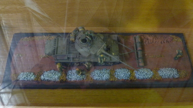
Model - Diorama
A diorama of a Centurion MBT mine clearance tank with roller drum configuration. Four x forty-four gallon drums filled with concrete and set on frame of water pipes. These were rolled along in front of the tank to bulldoze soil.mine clearing, centurion tank, roller drum, diorama -
 Bendigo Historical Society Inc.
Slide - ALLAN BUDGE COLLECTION: SLIDE HOUSE, QUEEN STREET, 1988
Slide, Allan Budge Collection: house, Queen Street.Verandah friezes in timber. One of a pair. Timber frieze.The gable treatment gives relief to another dull appearance.(Note: Fluted concrete verandah columns are almost certainly not original.)house, public, allan budge collection:, allan budge collection: -
Tatura Irrigation & Wartime Camps Museum
Photograph, Goulburn Weir, 1890
Taken by photographer for State Rivers and Water Supply Commission.Medium sized black and white photograph. Earthworks foreground, horse and dray lower right, men working on concrete weir structures, middle distance, - river with tree'd banks beyond, workmen's huts and house left of middle distancevictoria state rivers and water supply commission, goulburn weir -
Tatura Irrigation & Wartime Camps Museum
Photograph, Goulburn Weir, 1890
Taken by photographer for State Rivers and Water Supply Commission.Medium sized black and white photograph. View across weir - channel outlet left - earth and rubble wall separates two concrete and iron structures of weir. Trees on bank beyond beyond, buildings scattered amongst trees.victoria state rivers and water supply commission, goulburn weir -
 Lakes Entrance Historical Society
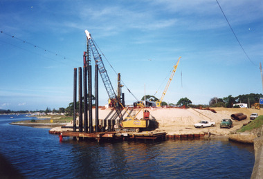
Photograph - North Arm Bridge, Davies Judy, 1999
Date made 10 April 1999Colour photograph of the southern abutment of the now North Arm Bridge during construction. Three cranes in attendance distant view of North Arm waterway, taken from walkway on old concrete road bridge. Lakes Entrance Victoriabridges, construction -
 Lakes Entrance Historical Society
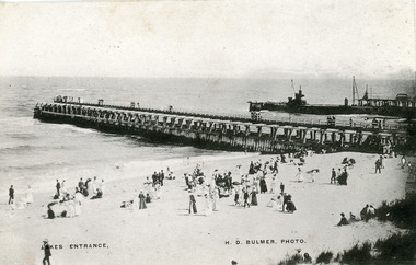
Photograph - Entrance Beach, Bulmer H D, 1910c
One other copy slightly sepia tinted 12 x 19cmBlack and white photograph showing piers and entrance to Gippsland Lakes from ocean Bass Strait. Work in progress on concrete extension to western pier showing cranes and machinery in use. People on beach and piers. Lakes Entrance VictoriaLakes Entrancewaterways, beaches, piers, machinery -
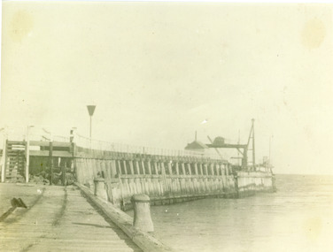
 Lakes Entrance Historical Society
Photograph - Western Pier, 1918c
Black and white photograph showing piers and entrance to lakes from ocean Bass Strait. Western pier in back ground shows concrete extension to original wooden pier. Wooden eastern pier in foreground. Lakes Entrance Victoriapiers, waterways -
 Bendigo Historical Society Inc.
Photograph - Kangaroo Flat Gold Mine Collection: Catherine Reef South shaft
Black and white photocopy of original photo. Image shows black square checker board steel capping on concrete base. Cap is situated on top of Catherine Reef South shaft, Eaglehawk. Shaft capped by Western Mining Corporation.On back in pencil: Catherine Reef South Shaft, WMC cap.western mining corporation, goldmining, capping, shaft, catherine reef south shaft, mining regulations -
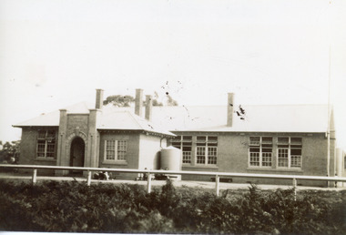 Lakes Entrance Historical Society
Photograph - Lakes Entrance State School, 1930 c
Black and white photograph of Lakes Entrance State School, Myer St., showing a concrete building, four chimneys through the roof, arched entry flanked by pillars with school name and number above arch. Lakes Entrance Victoriaschools, room display, buildings -
 Lakes Entrance Historical Society
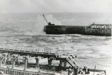
Photograph, Phillips Miss L, Entrance to Gippsland Lakes: Lakes Entrance, 1910c
Black and white photograph showing Eastern Pier and entrance to Gippsland Lakes from ocean - Bass Strait, photo shows work shed and crane on end of pier ready to build concrete extension on pier. Lakes Entrance Victoriapiers, ships and shipping, gippsland lakes -
 Ithacan Historical Society
Photograph, Frikes, Ithaca, c1970s
As the closest port to the mainland and neighbouring island Lefkada, Frikes was historically a trading port, supplying produce and merchandise to northern Ithaca. Today it is more a quiet fishing village which comes alive during the summer months with cafes and taverns. In summer tourist yachts moor at Frikes and a ferry service operates to Lefkada. A coloured photograph of he harbour at Frikes. Thee is a stone and concrete breakwater in the foreground where three fishing boats and a yacht are moored. A sedan is parked on the breakwater. Buildings are around the water's edge in the middle distance against a backdrop of mountains. ports, frikes