Showing 23072 items matching "creek"
-
 Eltham District Historical Society Inc
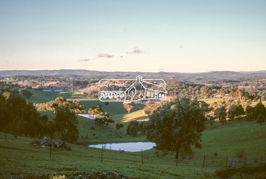
Slide - Photograph, Wet Gully, Diamond Creek, c.May 1988
Wet Gully (local name) between Eltham and Diamond Creek, bound by Reynolds and Lorimer roads, Diamond Creek, May 198835mm colour positive transparency (2 of 36) Mount - Kodak KodachromeProcess Date MAY 88Mdiamond creek, lorimer road, reynolds road, wet gully -
 Stawell Historical Society Inc
Archive, Pleasant Creek Special School (Stock List Books), 1937 - 1955
Former Pleasant Creek Hospital site. Sometimes referred to as Pleasant Creek Special School and sometimes Pleasant Creet Training Centre.Pale Grey Pater, some are red Boundstawell, education -
 Kiewa Valley Historical Society
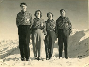
Photographs – Skippy St Elmo and other skiers – Set of 8 black and white photographs
Skippy and Toni St Elmo were responsible for early developments at the Falls Creek resort and for promoting a love of skiing. They left Melbourne in 1945 and settled at Falls Creek and moved into the first building constructed of corrugated iron and timber at Falls Creek in 1946. They were Falls Creek’s first workers with Toni employed by the State Electricity Commission to record weather-related data up to the construction of the Kiewa Hydro-Electric Scheme. In 1957, Toni was involved in building the first rope tow called Nissen on the same route as the Summit Quad. He also established the Nissen Ski School with ski instructor Milan Kovacic and was involved in the building of the resort’s first ski club Bogong in 1949. Toni taught Skippy to ski and she practised on the High Plains where she and her husband lived. Skippy St Elmo won many ski races during the 1950’s and represented Australia in New Zealand.Skippy and Toni St Elmo were pioneers of the Falls Creek area, promoting local ski sports and tourism. The played an important role in opening up the Falls Creek area and developing its sporting potential by establishing the first ski school, ski lifts and early lodge facilities. Skippy and Toni St Elmo were honoured at the Alpine Village at Falls Creek on November 17 2006, with the spreading of their ashes at the place which played such an important part in both their lives.Set of 8 black and white photographs of Skippy St Elmo and other skiers 1. Skippy and 3 others in New Zealand 1951 2. Skippy and 5 others Falls Creek 1955 3. Cake celebrating 20 years of sport at Nissen Lodge 4. Skippy and friend outside Nissen Lodge 5. Skippy on the ski slopes 6. Skippy on the ski slopes 7. Albury Ski Club team New Zwealand 1957 8. The Bogong Ski Club 1950 Written on back of photos 1. Bob Howe Albury, Skippy New Zealand 1951 – 942H 2. Falls Creek 1955. Skippy St Elmo: H Devonassore; Margaret ?; ?; Tony St Elmo; Olive? 3. Written on cake Nissen Alpine Club. 20 years of sport. FRED 4. Skippy St Elmo 5. Skippy 6. Skippy 7. Bob Howe (Albury) Skippy New Zealand 1957. Albury Ski Club Team raced in NZ 8. The Bogong Ski club, Coronet Park, 1950. M Denham (Capt); B Wiltshire; R Roberts; Skippy St Elmo; Gwen Morris; J Frazer; J Smith; L Piera; Manager & Coach Toni St Elmo. J D Knowles Photographer Box 188, Queenstown. 744B falls creek, skiing, bogong high plains -
 Eltham District Historical Society Inc
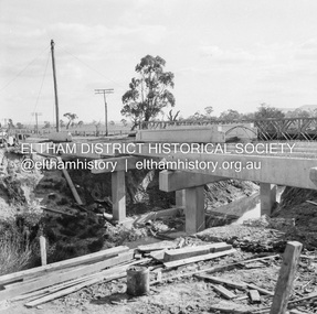
Negative - Photograph, J.A. McDonald, Eltham-Diamond Creek Road, May 1958
Wing pier Eltham abutment Bridge construction Eltham-Diamond Creek road over the Diamond Creek (Wattletree Road), Eltham, May 1958Record of various Shire of Eltham infrastructure works undertaken during the period of 1952-1962 involving bridge and road reconstruction projects, sometimes with Eltham Shire Council Project Reference numbers quoted. It was during this period that a number of significant improvements were made to roads and new bridges constructed within the shire that remain in place as of present day (2022). In many situations, the photos provide a tangible visible record of infrastructure that existed throughout the early days of the Shire. The album was put together by or under the direction of the Shire Engineer, J.A. McDonald.infrastructure, shire of eltham, 1958-05, bridge construction, wattletree road bridge -
 Lorne Historical Society
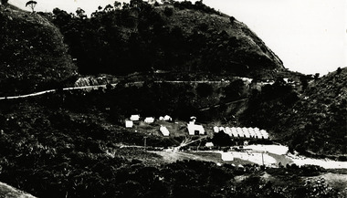
Photograph, Grassy Creek C.R.B. Camp
Photo of the Grassy Creek C.R.B site looking towards Aireys Inlet. Top left hand corner - the first tents were the gangers next were the mine and the third the timekeepers. The camp site is in the valleyg.o.r.; c.r.b. construction camp sites; gangers; mine; timekeeper; grassy creek; -
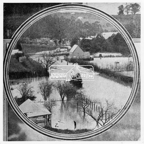
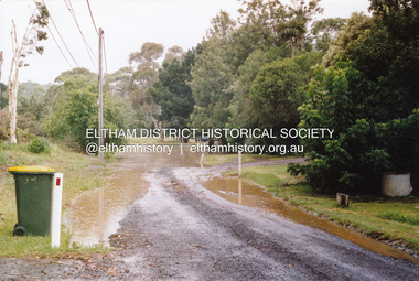 Eltham District Historical Society Inc
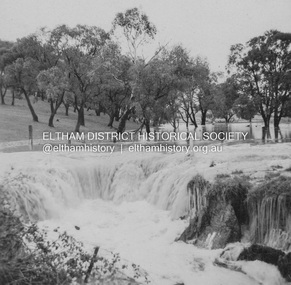
Photograph, Flooding of Diamond Creek, Eltham, Feb 2005, 2005
Two colour photographs of the Diamond Creek floodwater; two at Souter Street and one looking north across the Eltham Rugby Union Football Club oval towards the Bridge Street bridge, Feb 2005eltham, diamond creek, floods, souter street, bridge street -
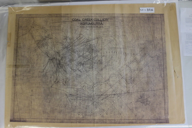 Coal Creek Community Park & Museum
Map of Mine and Details, Coal Creek Colliery Korumburra
8516.1 - Schematic/map of coal creek mine workings, also detailing number surface features such as topographic heights, roads, railways, boreholes, etc. No Legend. Most information seems to be printed, with topography drawn on. -
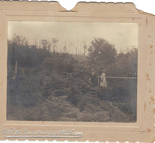 Emerald Museum & Nobelius Heritage Park
B/W Photograph, December 1904
The card was probably sent as a Christmas gift to an unknown recipient by "H & GB", presumably a married couple. The two women in the photo might be known to sender and receiver, or might even be the receivers. The scene is suspected to be in the grounds of the Country Club at Emerald, Victoria.As the card is clearly dated, and the figures clearly named, it is a record of people resident in Emerald. From it we can make out some details of their dress and the physical surroundings of the time.B/W photograph mounted on embossed cardboard with crimped edges. It depicts two women standing on a small bridge over a creek in dense vegetation. There are trees in the background and ferns in the foreground. Front bottom left: silver embossed "With the Compliments of the Season" Rear: Handwritten "Mrs Airey & Miss Doolan on Bridge over Creek From ?H & ?GB 18?/12/1904" At bottom: "May be Country Club"airey, doolan, creek, country club, 1904 -
 Department of Health and Human Services
Photograph, Front of building and roundabout of Pleasant Creek Special School - Stawell - Circa 1940 to 1950
Pleasant Creek Colony history in brief Warning about distressing information Patient information Disclaimer Source On this page: Pleasant Creek Colony history in brief Warning about distressing information Patient information Disclaimer Source Pleasant Creek Colony history in brief In 1861, the Pleasant Creek Hospital opened as a medical facility for the population of Stawell and district. Another building was added in 1904, Syme Ward for convalescent patients. In 1933, the facility was replaced by a newly-built hospital in the town of Stawell. In 1934, the Mental Hygiene Department acquired the old Pleasant Creek Hospital site and converted it to accommodate children with disabilities, which became Pleasant Creek Special School. The first residents (18 boys) were admitted in 1937 from Royal Park Depot. At the end of 1937, there were 98 children living at Pleasant Creek. In 1968 the Pleasant Creek Special School was renamed Pleasant Creek Training Centre, caring for people with intellectual disabilities. From the 1950s to the 1980s, there were several building developments: •1957, Lonsdale Unit expanded capacity to 113 •1969, Bellfield and Fyans Units increased numbers to 196 •1977, Alexandra Unit converted to recreational and lecture room facility. •1977, Day Centre, Nurses' Home and Clinical Services Administration buildings •1985, Nara Unit closed for renovations and residents moved to the previous staff living quarters. https://www.findingrecords.dhhs.vic.gov.au/CollectionResultsPage/Pleasant-Creek-Colony -
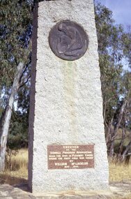 Stawell Historical Society Inc
Slide, Ian McCann, Gold Memorial Pleasant Creek 1971
Monument to commemorate where gold was first found in StawellOn Insert near base of Monument. Erected by the Stawell Progress Association Near the spot in Pleasant Creek where the first Gold was found By William McLachlan May 1853monuments, gold -
 Lake Bolac & District Historical Society
Black and white photograph, Fiery Creek Entrance
Fiery Creek inlet to Lake Bolac during the 1997-2010 drought. Photograph taken from the dry lake-bed looking up the creek, towards the south.lake bolac, fiery creek, 1997-2010 drought -
 Eltham District Historical Society Inc
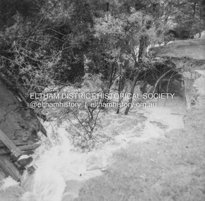
Album - Photograph, J.A. McDonald, Dixons Creek Road, 23 Sep. 1955
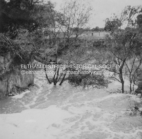
Dixons Creek in floodRecord of various Shire of Eltham infrastructure works undertaken during the period of 1952-1962 involving bridge and road reconstruction projects, sometimes with Eltham Shire Council Project Reference numbers quoted. It was during this period that a number of significant improvements were made to roads and new bridges constructed within the shire that remain in place as of present day (2022). In many situations, the photos provide a tangible visible record of infrastructure that existed throughout the early days of the Shire. The album was put together by or under the direction of the Shire Engineer, J.A. McDonald.1955-09-23, bridge construction, dixons creek bridge, dixon's creek road, flood damage, floods, infrastructure, road construction, shire of eltham -
 Eltham District Historical Society Inc
Album - Photograph, J.A. McDonald, Dixons Creek Road, 23 Sep. 1955
Dixons Creek in floodRecord of various Shire of Eltham infrastructure works undertaken during the period of 1952-1962 involving bridge and road reconstruction projects, sometimes with Eltham Shire Council Project Reference numbers quoted. It was during this period that a number of significant improvements were made to roads and new bridges constructed within the shire that remain in place as of present day (2022). In many situations, the photos provide a tangible visible record of infrastructure that existed throughout the early days of the Shire. The album was put together by or under the direction of the Shire Engineer, J.A. McDonald.1955-09-23, bridge construction, dixons creek bridge, dixon's creek road, flood damage, floods, infrastructure, road construction, shire of eltham -
 Federation University Historical Collection
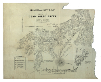
Map, Dead Horse Creek, 1887, 29/05/1887
Geological sketch map of a portion of Dead Horse Creek. WGS 84 Centroid Lat: 36 degrees 50 inches S Long: 148 degrees 00 inches S NS: 4.3km EW 4.8kmdead horse creek, james stirling, gold, geology, mount cobberas -
 Whitehorse Historical Society Inc.
Photograph, Deep Creek Road, Mitcham, 1/01/2001 12:00:00 AM
Black and white photograph of Deep Creek Road, Mitcham taken from lower entrance of Schwerkolt Cottage Reserve showing Glenvale Road on left. Photo taken before work started on new road and bridge.deep creek road, mitcham, glenvale road, ringwood -
Clunes Museum
Photograph
TWO PHOTOGRAPHS OF BUILDING A BANK BETWEEN THE CREEK AND THE FOOTBALL GROUND IN 2012football ground, creek -
 Eltham District Historical Society Inc
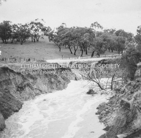
Photograph, Leader Publishing Co, Floods at Diamond Creek, Sep. 1924
The Diamond Creek in flood in Diamond Creek township. View north along Diamond Street. The building in the middle distance is the Methodist Church. From "The Leader", 6 September 1924.This photo forms part of a collection of photographs gathered by the Shire of Eltham for their centenary project book, "Pioneers and Painters: 100 years of the Shire of Eltham" by Alan Marshall (1971). The collection of over 500 images is held in partnership between Eltham District Historical Society and Yarra Plenty Regional Library (Eltham Library) and is now formally known as 'The Shire of Eltham Pioneers Photograph Collection.' It is significant in being the first community sourced collection representing the places and people of the Shire's first one hundred years.Digital imageshire of eltham pioneers photograph collection, diamond creek, floods, methodist church, diamond creek (creek), diamond street, 1924 -
 Falls Creek Historical Society
Booklet - Falls Creek Cross Country Trail Guide 1999
This publication was developed by the Falls Creek Resort Management Committee to promote activities and facilities at Falls Creek for the Winter Season 1999. It was a publication specifically focused on cross country skiers. This item is significant because it illustrates how Falls Creek has been marketed and promoted over time.A coloured fold out trail guide including a map of all trailsfalls creek trails, falls creek marketing, falls creek promotion, cross country skiing -
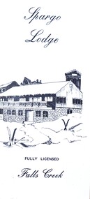 Falls Creek Historical Society
Flyer - Spargo Lodge
Ivan Spargo was a builder in Melbourne. In 1965 he and his wife Joy leased piece of land in Falls Creek and built Spargo Lodge. It was a dormitory style chalet designed to accommodate large groups and families. Their son, Rob and his wife Blanche purchased the site where the Falls Creek Hotel is today. In 1970 Rob’s sister Leonie and her husband Glenn joined the business, and they started operating in 1972. The family has been actively involved in the Falls Creek Community including the establishment of the Falls Creek Primary School and Falls Creek Search & Rescue. Rob also served as a member the Chamber and Resort Management Board. As the next generation stepped into the family business, Rob and Blanche retired to their home in Tawonga South in 2014 and Leonie and Glenn retired to Melbourne in 2017.This brochure is significant because it is linked to a prominent business and family in Falls Creek, Victoria. A small brochure publicising Spargo Lodge, Falls Creek. It is printed in brown text on buff coloured light card. When unfolded, one side shows a sketch of Spargo Lodge. The reverse side gives information about facilities and services, the tariff for regular and peak season, booking details and transport information.On front: Spargo Lodge FULLY LICENSED Falls Creekspargo lodge, falls creek accommodation, falls creek hotel -
 Greensborough Historical Society
Map, Melbourne and Metropolitan Board of Works. Survey Division, MMBW, Yarra 2500 / 15.24. Diamond Creek, Grassy Flat Road, 1978_02
Melbourne and Metropolitan Board of Works. Yarra 2500 [base map] 15.24. Diamond Creek, Grassy Flat Road. Parish of Nillumbik 3310. Municipality of Diamond Valley 257. Prominent streets include: Everleigh Drive, Broad Gully Road and Clyde Street. Features include the Diamond Creek, Nillumbik Park and Diamond Creek Reservoir.MMBW Map in 1:2500 [scale] series. Cream parchment with green tape reinforcing on edges and punched holes on left edge.mmbw, melbourne and metropolitan board of works, diamond creek - maps, shire of diamond valley -
 Ringwood and District Historical Society
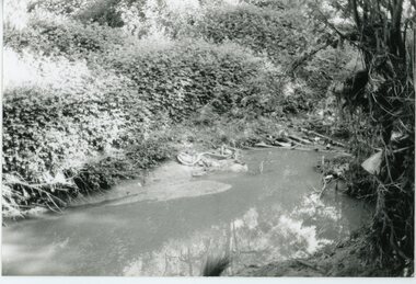
Photograph, Mullum Mullum Creek- 29-10-89
Black and white photograph"Written on back of photograph" Mullum Mullum Creek From North bank (Munro St side)View generally downstream West of Harrison St Note rubbish and weeds. -
 Eltham District Historical Society Inc
Negative - Photograph, J.A. McDonald, Dixons Creek Road, c.May 1958
Dixons Creek Contractor MorrisRecord of various Shire of Eltham infrastructure works undertaken during the period of 1952-1962 involving bridge and road reconstruction projects, sometimes with Eltham Shire Council Project Reference numbers quoted. It was during this period that a number of significant improvements were made to roads and new bridges constructed within the shire that remain in place as of present day (2022). In many situations, the photos provide a tangible visible record of infrastructure that existed throughout the early days of the Shire. The album was put together by or under the direction of the Shire Engineer, J.A. McDonald.infrastructure, shire of eltham, 1958-05, bridge construction, dixons creek bridge, dixon's creek road -
 Stawell Historical Society Inc
Photograph, Salt Creek Bridge 1993 -- Coloured
Salt Creek Bridge 1993stawell -
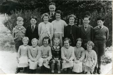 Stawell Historical Society Inc
Photograph, Greens Creek School Students 1954
Greens Creek Students 1954stawell -
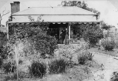 Stawell Historical Society Inc
Photograph, Pearce Family Home in Doctors Creek
Pearce Home. Doctors Creekstawell -
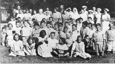 Stawell Historical Society Inc
Photograph, Pleasant Creek Special School Staff and Children
Pleasant Creek Staff and Childrenstawell -
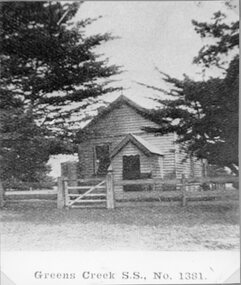 Stawell Historical Society Inc
Photograph, Greens Creek School Number 1381
School - Greens Creek No. 1381 stawell education -
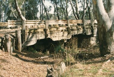
 Wonga Park Community Cottage History Group
Photograph (Item) - Black and White, Wonga Park: Old Jumping Creek Bridge, c. 1931
Old Jumping Creek BridgePhoto is named 14880026.jpg on CD