Showing 28438 items matching "dc-3"
-
 National Vietnam Veterans Museum (NVVM)
Audio - Audio, CD, Men at war and peace: the good old nuddie buddies (3 copies)
Song, the good old nuddie buddies sung by Peter Perez. There is also 3 copies of the Memorabilia & 1 of the Naked Truthvietnam veterans -
 National Vietnam Veterans Museum (NVVM)
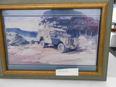
Painting, Framed Painting, Series 3 Landrover
Framed painting of Series 3 landrover purchased to tow Vietnam veterans Mobile Museum. Painting is signed by D. LevershaRego NRP 110framed painting, painting, landrover, vietnam veterans mobile museum -
Tatura Irrigation & Wartime Camps Museum
Photograph, Camp 3
Photographs taken in camp 3, 1943-1947. Alfreda Kaltenbach born in Mooroopna Hospital while her parents interned..kaltenbach collection, camp 3, alfrieda faig, elfriede kaltenbach -
 Ballarat Tramway Museum
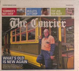
Newspaper, What's old is new again - 3-2-2022
Article by Ellie Mitchell, photo by Adam Trafford with photos of Neville Britton and Geelong tram No. 2, providing details of the tram, its reconstruction and the launch. Quotes Rod Atkins, Vice President of the COTMA, and details of visiting the museum.Yields information about the formal launch of Geelong tram No. 2Newspaper - The Courier, front page and page 2 - What's old is new again - 3-2-2022 - Geelong 2btm, tramways, tram 2, geelong, tramcars -
 Stawell Historical Society Inc
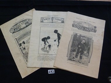
Book, Education Department of Victoria, School Paper 1931 & 1933 & 3 Supplements, 1930's
The School Paper published monthly. Cost 1 Penny (2 Cents) Used in State Schools2 Paper booklets & 3, 4 page, supplements. 0682 has a photo of a boy holding a stick wearing unlaced boots, (after the painting by Bastien Lepage) 0682-1 is a supplement with a Picture of girls in a large room sitting in front of electric sewing machines. 0682-2 supplement: Contains photo of a certificate from the Victorian State Schools League of Kindness. 0682-3 Black and white drawing of two children in silhouette. on the beach with bucket and spade.0682-4 Supplement a picture of a variety of toys. 0682-5. drawing of children of different nationalities.0682: Midwinter. Days grow Longer. - Signs of Spring. Education Department. Victoria Australia The School Paper Grades VII and VIII. No 369. Melbourne Price 1d [July 1 1931. 0682-1: Supplement to the School Paper - Grades VII and VIII July 1931. 1. Made in Australia. 80. Girls and Womans Wear. 0682-2: Supplement to the School Paper - All Grades July 1931.1 The Protection of Animals. 0682-3: Hurrah for the Holidays Education Department. Victoria Australia The School Paper Grades III and IV. No 403. Melbourne Price 1d [Dec 1 1931. 0682-4: Supplement For the School Paper - Grades III and IV December 1931. 1.Made In Australia 85. Toys. 0682-5: No Cold, No Care, November Education Department. Victoria Australia The School Paper Grades V and VI. No 409. Melbourne Price 1d [Nov. 1 1931.stawell education -
Tatura Irrigation & Wartime Camps Museum
Book, Disturbance Camp 3
This book contains copies of the official Reports of the Disturbance camp 3.Black cover A 4 booklet containing photocopied pages. -
 Tatura Irrigation & Wartime Camps Museum
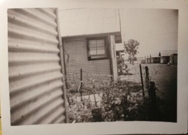
Photograph, Camp 3 compound
Shows what some of the huts looked like in Camp 3.Black and white photograph depicting, on the left, the corrugated side of a hut with part of another hut behind it with bits of other huts behind that. On the right hand side more huts can be seen. Part of a garden can be seen next to the corrugated side.camp 3, camp huts, internee living accommodation -
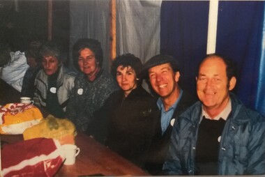 Tatura Irrigation & Wartime Camps Museum
Photograph, Camp 3 Classmates Reunion
Camp 3 class mates from 1938 at a reunion in 1988. Colour photograph of 5 people seated at a table, on the right hand side a royal blue cloth with a white line. Behind head of man on right with adjacent back drop grey with yellow stripe. Informal get together. Photograph is on coreflue class mates reunion, peter drescher, camp 3 reunion -
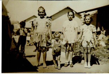 Tatura Irrigation & Wartime Camps Museum
Photograph, Patrizia Grille and friends Camp 3
The Grille family were internees in Camp 3 during WW2.Sepia photograph of Francesco, Fransecea and Patrizia Grille outside one of the barrack huts. internment camp 3, grille family, patrizia grille -
 Tatura Irrigation & Wartime Camps Museum
Photograph, Camp 3 internees
Group of internees from Camp 3 Rushworth during WW2.Black and white photograph of a group of men and women in front of a hut with open doors.camp 3 internees -
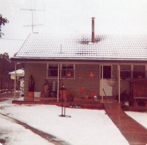 Stawell Historical Society Inc
Photograph, Snow Scene at 3 Mahnke Street Stawell 1981 -- 2 Photos -- Coloured
Snow Scene 3 Mahnke Street Stawell June 1981stawell -
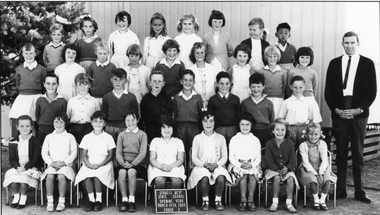 Stawell Historical Society Inc
Photograph, Stawell West Primary School Number 4934 -- Grade 3 1965
Class photo Grade 3 Stawell West Students 1965stawell education -
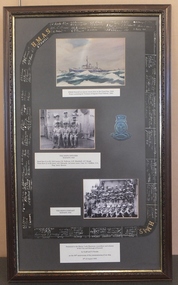 Stawell Historical Society Inc
Photograph, H.M.A.S. Stawell -- Framed -- 3 Photos
H.M.A.S. Stawell (3 Photos) Two of Crew as in Cat No 1402stawell -
Stawell Historical Society Inc
Photograph, Lady Brooks Kindergarten 3 Year old Students 1979 -- Coloured
Lady Brooks Kindergarten 1979 3 Year Old Groupstawell -
Stawell Historical Society Inc
Photograph, Lady Brooks Kindergarten 3 Year old Students 1979 -- Coloured
Lady Brooks Kindergarten 1979 3 Year Old Groupstawell -
Stawell Historical Society Inc
Photograph, Lady Brooks Kindergarten 3 Year old Students 1981 -- Coloured
Lady Brooks Kindergarten 1981 3 Year Old Groupstawell -
Stawell Historical Society Inc
Photograph, Lady Brooks Kindergarten 3 Year old Students 1981 -- Coloured
Lady Brooks Kindergarten 1981 3 Year Old Groupstawell -
Stawell Historical Society Inc
Photograph, Lady Brooks Kindergarten 3 Year old Students 1983 -- Coloured
Lady Brooks Kindergarten 1983 3 Year Old Groupstawell -
Stawell Historical Society Inc
Photograph, Lady Brooks Kindergarten 3 Year old Students 1983 -- Coloured
Lady Brooks Kindergarten 1983 3 Year Old Groupstawell -
Stawell Historical Society Inc
Photograph, Lady Brooks Kindergarten 3 Year old Students 1985 -- Coloured
Lady Brooks Kindergarten 1985 3 Year Old Groupstawell -
Stawell Historical Society Inc
Photograph, Lady Brooks Kindergarten 3 Year old Students 1985 -- Coloured
Lady Brooks Kindergarten 1985 3 Year Old Groupstawell -
 Wonga Park Community Cottage History Group
Photograph (Item) - Black and White, Wonga Park: The Oaks 3 in garden
Wonga Park: The Oaks 3 in garden and lady in front of housePhoto is named 14880029.jpg on CD -
Alfred Hospital Nurses League - Nursing Archive
Document - Fictional Alfred Hospital Medical Record (copy), Medical Record of Klaus (AKA Claus) Santa UR 999995 Folder No.3 (1994-), December 1999
Fictional Medical Record of Santa ClausBuff coloured folder with green spine and multicoloured horizontal stripes containing papers fixed by split pinsfictionFictional Medical Record of Santa Claushospital humour, alfred hospital, ahnl, christmas, santa claus -
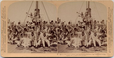 Australian Army Museum of Western Australia
Stereographic Image, 1900
Marines of HMS "Niobe" cheering news from the front, Capetown, South Africa Stereoscope #3 from a boxed set "For Queen and Flag: South Africa 1900" by Underwood and Underwood, Publishers Works and Studios: Arlington NJ; Littleton NH; Washington DCstereoscope, boer war, south africa, capetown -
 Flagstaff Hill Maritime Museum and Village
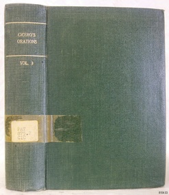
Book, The Orations of Marcus Tullius Cicero Vol 3
WARRNAMBOOL PUBLIC LIBRARY The Warrnambool Mechanics’ Institute (WMI) was formed by a voluntary community group in 1863, within six years of Warrnambool’s beginnings, and its Reading Room opened in 1854. The WMI operated until 1963, at which time it was one of the oldest Mechanics’ Institutes in Victoria. Mechanics’ Institutes offered important services to the public including libraries, reading rooms and places to display and store collections of all sorts such as curiosities and local historical relics. In 1886 a Museum and Fine Arts Gallery were added to the WMI and by the beginning of the 20th century there was also a billiards room and a School of Art. By this time all Mechanics’ Institutes in country Victoria had museums attached. Over the years the Warrnambool Mechanics’ Institute Library was also known as the Warrnambool Public Library the Warrnambool Library and the Free Library. Early funding from the government was for the “Free Library”. The inscription in a book “Science of Man” was for the “Warrnambool Public Library”, donated by Joseph Archibald in 1899. Another inscription in the book “Catalogue of Plants Under Cultivation in the Melbourne Botanic Gardens 1 & 2, 1883” was presented to the “Warrnambool Library” and signed by the author W.R. Guilfoyle. In 1903 the Warrnambool Public Library decided to add a Juvenile Department to library and stock it with hundreds of books suitable for youth. In 1905 the Public Library committee decided to update the collection of books and added 100 new novels plus arrangements for the latest novels to be included as soon as they were available in Victoria. In July 1911 the Warrnambool Council took over the management of the Public Library, Art Gallery, Museum and Mechanics’ Institute and planned to double the size of the then-current building. In 1953, when Mr. R. Pattison was Public Librarian, the Warrnambool Public Library’s senior section 10,000 of the 13,000 books were fiction. The children’s section offered an additional 3,400 books. The library had the equivalent of one book per head of population and served around 33 percent of the reading population. The collection of books was made up of around 60 percent reference and 40 percent fiction. The library was lending 400 books per day. In 1963 the Warrnambool City Council allocated the site of the Mechanics’ Institute building, which included the Public Library, Museum and Art Gallery, for the new Municipal Offices and the Collections were dispersed until 1971. The Warrnambool Library took over the Mechanics’ Institute Library’s holdings on behalf of the Warrnambool City Council. Since the closure of the Warrnambool Mechanics’ Institute the exact location and composition of the original WMI books and items has become unclear. Other materials have been added to the collection, including items from Terang MI, Warrnambool Court House and Customs House. Many of the books have been identified as the Pattison Collection, named after the Librarian who catalogued and numbered the books during his time as Warrnambool Public Librarian in the time before the Mechanics’ Institute closed. It seems that when Warrnambool became part of the Corangamite Regional Library some of the books and materials went to its head office in Colac and then back to Warrnambool where they were stored at the Art Gallery for quite some time. Some then went to the Warrnambool Historical Society, some stayed at the Art Gallery and some were moved to Flagstaff Hill Maritime Village. The various stamps and labels on the books held at Flagstaff Hill show the variety of the collection’s distribution and origin. The books in the collection at Flagstaff Hill Maritime Village date from the 1850’s to the late 1950’s and include rare and valuable volumes. Many of the books are part of the “Pattison Collection” after the Warrnambool’s Public Librarian, Mr. R. Pattison. This item is from the ‘Pattison Collection’, a collection of books and records that was originally owned by the Warrnambool Mechanics’ Institute, which was founded in Warrnambool in 1853. By 1886 the Warrnambool Mechanics’ Institute (WMI) had grown to have a Library, Museum and Fine Arts Gallery, with a collection of “… choice productions of art, and valuable specimens in almost every branch and many wonderful national curiosities are now to be seen there, including historic relics of the town and district.” It later included a School of Design. Although it was very well patronised, the lack of financial support led the WMI in 1911 to ask the City Council to take it over. In 1935 Ralph Pattison was appointed as City Librarian to establish and organise the Warrnambool Library as it was then called. When the WMI building was pulled down in 1963 a new civic building was erected on the site and the new Warrnambool Library, on behalf of the City Council, took over all the holdings of the WMI. At this time some of the items were separated and identified as the ‘Pattison Collection’, named after Ralph Pattison. Eventually the components of the WMI were distributed from the Warrnambool Library to various places, including the Art Gallery, Historical Society and Flagstaff Hill. Later some were even distributed to other regional branches of Corangamite Regional Library and passed to and fro. It is difficult now to trace just where all of the items have ended up. The books at Flagstaff Hill Maritime Village generally display stamps and markings from Pattison as well as a variety of other institutions including the Mechanics’ Institute itself. RALPH ERIC PATTISON Ralph Eric Pattison was born in Rockhampton, Queensland, in 1891. He married Maude Swan from Warrnambool in 1920 and they set up home in Warrnambool. In 1935 Pattison accepted a position as City Librarian for the Warrnambool City Council. His huge challenge was to make a functional library within two rooms of the Mechanics’ Institute. He tirelessly cleaned, cleared and sorted a disarrayed collection of old books, jars of preserved specimens and other items reserved for exhibition in the city’s museum. He developed and updated the library with a wide variety of books for all tastes, including reference books for students; a difficult task to fulfil during the years following the Depression. He converted all of the lower area of the building into a library, reference room and reading room for members and the public. The books were sorted and stored using a cataloguing and card index system that he had developed himself. He also prepared the upper floor of the building and established the Art Gallery and later the Museum, a place to exhibit the many old relics that had been stored for years for this purpose. One of the treasures he found was a beautiful ancient clock, which he repaired, restored and enjoyed using in his office during the years of his service there. Ralph Pattison was described as “a meticulous gentleman whose punctuality, floorless courtesy and distinctive neat dress were hallmarks of his character, and ‘his’ clock controlled his daily routine, and his opening and closing of the library’s large heavy doors to the minute.” Pattison took leave during 1942 to 1945 to serve in the Royal Australian Navy, Volunteer Reserve as Lieutenant. A few years later he converted one of the Museum’s rooms into a Children’s Library, stocking it with suitable books for the younger generation. This was an instant success. In the 1950’s he had the honour of being appointed to the Victorian Library Board and received more inspiration from the monthly conferences in Melbourne. He was sadly retired in 1959 after over 23 years of service, due to the fact that he had gone over the working age of council officers. However he continued to take a very keen interest in the continual development of the Library until his death in 1969. The Pattison Collection, along with other items at Flagstaff Hill Maritime Village, was originally part of the Warrnambool Mechanics' Institute’s collection. The Warrnambool Mechanics’ Institute Collection is primarily significant in its totality, rather than for the individual objects it contains. Its contents are highly representative of the development of Mechanics' Institute libraries across Australia, particularly Victoria. A diversity of publications and themes has been amassed, and these provide clues to our understanding of the nature of and changes in the reading habits of Victorians from the 1850s to the middle of the 20th century. The collection also highlights the Warrnambool community’s commitment to the Mechanics’ Institute, reading, literacy and learning in the regions, and proves that access to knowledge was not impeded by distance. These items help to provide a more complete picture of our community’s ideals and aspirations. The Warrnambool Mechanics Institute book collection has historical and social significance for its strong association with the Mechanics Institute movement and the important role it played in the intellectual, cultural and social development of people throughout the latter part of the nineteenth century and the early twentieth century. The collection of books is a rare example of an early lending library and its significance is enhanced by the survival of an original collection of many volumes. The Warrnambool Mechanics' Institute’s publication collection is of both local and state significance. The Orations of Marcus Tullius Cicero Vol 3 Translated by C D Yonge Publisher: Henry G Bohn Date: 1852Label on spine cover with typed text PAT 875.2 CIC Pastedown front endpaper has sticker from Warrnambool Public Library Front loose endpaper has a sticker from Corangamite Regional Library Service Front loose endpaper has a stamp from Corangamite Regional Library Service warrnambool, shipwrecked-coast, flagstaff-hill, flagstaff-hill-maritime-museum, maritime-museum, shipwreck-coast, flagstaff-hill-maritime-village, shipwrecked-artefact, book, pattison collection, warrnambool library, warrnambool mechanics’ institute, ralph eric pattison, corangamite regional library service, warrnambool city librarian, mechanics’ institute library, victorian library board, warrnambool books and records, warrnambool children’s library, great ocean road, the orations of marcus tullius cicero vol 3, the orations of marcus tullius cicero, c d yonge -
 Flagstaff Hill Maritime Museum and Village
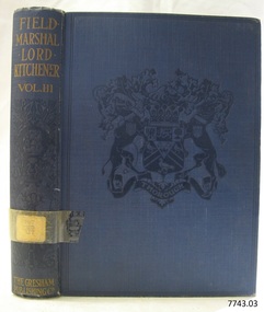
Book, Field-Marshal Lord Kitchener Vol 3
This item is from the ‘Pattison Collection’, a collection of books and records that was originally owned by the Warrnambool Mechanics’ Institute, which was founded in Warrnambool in 1853. By 1886 the Warrnambool Mechanics’ Institute (WMI) had grown to have a Library, Museum and Fine Arts Gallery, with a collection of “… choice productions of art, and valuable specimens in almost every branch and many wonderful national curiosities are now to be seen there, including historic relics of the town and district.” It later included a School of Design. Although it was very well patronised, the lack of financial support led the WMI in 1911 to ask the City Council to take it over. In 1935 Ralph Pattison was appointed as City Librarian to establish and organise the Warrnambool Library as it was then called. When the WMI building was pulled down in 1963 a new civic building was erected on the site and the new Warrnambool Library, on behalf of the City Council, took over all the holdings of the WMI. At this time some of the items were separated and identified as the ‘Pattison Collection’, named after Ralph Pattison. Eventually the components of the WMI were distributed from the Warrnambool Library to various places, including the Art Gallery, Historical Society and Flagstaff Hill. Later some were even distributed to other regional branches of Corangamite Regional Library and passed to and fro. It is difficult now to trace just where all of the items have ended up. The books at Flagstaff Hill Maritime Village generally display stamps and markings from Pattison as well as a variety of other institutions including the Mechanics’ Institute itself. RALPH ERIC PATTISON Ralph Eric Pattison was born in Rockhampton, Queensland, in 1891. He married Maude Swan from Warrnambool in 1920 and they set up home in Warrnambool. In 1935 Pattison accepted a position as City Librarian for the Warrnambool City Council. His huge challenge was to make a functional library within two rooms of the Mechanics’ Institute. He tirelessly cleaned, cleared and sorted a disarrayed collection of old books, jars of preserved specimens and other items reserved for exhibition in the city’s museum. He developed and updated the library with a wide variety of books for all tastes, including reference books for students; a difficult task to fulfil during the years following the Depression. He converted all of the lower area of the building into a library, reference room and reading room for members and the public. The books were sorted and stored using a cataloguing and card index system that he had developed himself. He also prepared the upper floor of the building and established the Art Gallery and later the Museum, a place to exhibit the many old relics that had been stored for years for this purpose. One of the treasures he found was a beautiful ancient clock, which he repaired, restored and enjoyed using in his office during the years of his service there. Ralph Pattison was described as “a meticulous gentleman whose punctuality, floorless courtesy and distinctive neat dress were hallmarks of his character, and ‘his’ clock controlled his daily routine, and his opening and closing of the library’s large heavy doors to the minute.” Pattison took leave during 1942 to 1945 to serve in the Royal Australian Navy, Volunteer Reserve as Lieutenant. A few years later he converted one of the Museum’s rooms into a Children’s Library, stocking it with suitable books for the younger generation. This was an instant success. In the 1950’s he had the honour of being appointed to the Victorian Library Board and received more inspiration from the monthly conferences in Melbourne. He was sadly retired in 1959 after over 23 years of service, due to the fact that he had gone over the working age of council officers. However he continued to take a very keen interest in the continual development of the Library until his death in 1969. The Pattison Collection, along with other items at Flagstaff Hill Maritime Village, was originally part of the Warrnambool Mechanics' Institute’s collection. The Warrnambool Mechanics’ Institute Collection is primarily significant in its totality, rather than for the individual objects it contains. Its contents are highly representative of the development of Mechanics' Institute libraries across Australia, particularly Victoria. A diversity of publications and themes has been amassed, and these provide clues to our understanding of the nature of and changes in the reading habits of Victorians from the 1850s to the middle of the 20th century. The collection also highlights the Warrnambool community’s commitment to the Mechanics’ Institute, reading, literacy and learning in the regions, and proves that access to knowledge was not impeded by distance. These items help to provide a more complete picture of our community’s ideals and aspirations. The Warrnambool Mechanics Institute book collection has historical and social significance for its strong association with the Mechanics Institute movement and the important role it played in the intellectual, cultural and social development of people throughout the latter part of the nineteenth century and the early twentieth century. The collection of books is a rare example of an early lending library and its significance is enhanced by the survival of an original collection of many volumes. The Warrnambool Mechanics' Institute’s publication collection is of both local and state significance. Field-Marshal Lord Kitchener Vol 3 Author: E S Grew Publisher: The Gresham Publishing Co Date: 1917Label on spine cover with typed text PAT 920 KIT Pastedown front endpaper has sticker from Warrnambool Mechanics Institute and Free Library Front loose endpaper has a sticker from Corangamite Regional Library Service Front loose endpaper has a stamp from Corangamite Regional Library Service warrnambool, shipwrecked-coast, flagstaff-hill, flagstaff-hill-maritime-museum, maritime-museum, shipwreck-coast, flagstaff-hill-maritime-village, shipwrecked-artefact, book, pattison collection, warrnambool library, warrnambool mechanics’ institute, ralph eric pattison, corangamite regional library service, warrnambool city librarian, mechanics’ institute library, victorian library board, warrnambool books and records, warrnambool children’s library, great ocean road, field-marshal lord kitchener vol 3, e s grew -
 Flagstaff Hill Maritime Museum and Village
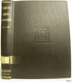
Book, Progressive Farming Vol 3
This item is from the ‘Pattison Collection’, a collection of books and records that was originally owned by the Warrnambool Mechanics’ Institute, which was founded in Warrnambool in 1853. By 1886 the Warrnambool Mechanics’ Institute (WMI) had grown to have a Library, Museum and Fine Arts Gallery, with a collection of “… choice productions of art, and valuable specimens in almost every branch and many wonderful national curiosities are now to be seen there, including historic relics of the town and district.” It later included a School of Design. Although it was very well patronised, the lack of financial support led the WMI in 1911 to ask the City Council to take it over. In 1935 Ralph Pattison was appointed as City Librarian to establish and organise the Warrnambool Library as it was then called. When the WMI building was pulled down in 1963 a new civic building was erected on the site and the new Warrnambool Library, on behalf of the City Council, took over all the holdings of the WMI. At this time some of the items were separated and identified as the ‘Pattison Collection’, named after Ralph Pattison. Eventually the components of the WMI were distributed from the Warrnambool Library to various places, including the Art Gallery, Historical Society and Flagstaff Hill. Later some were even distributed to other regional branches of Corangamite Regional Library and passed to and fro. It is difficult now to trace just where all of the items have ended up. The books at Flagstaff Hill Maritime Village generally display stamps and markings from Pattison as well as a variety of other institutions including the Mechanics’ Institute itself. RALPH ERIC PATTISON Ralph Eric Pattison was born in Rockhampton, Queensland, in 1891. He married Maude Swan from Warrnambool in 1920 and they set up home in Warrnambool. In 1935 Pattison accepted a position as City Librarian for the Warrnambool City Council. His huge challenge was to make a functional library within two rooms of the Mechanics’ Institute. He tirelessly cleaned, cleared and sorted a disarrayed collection of old books, jars of preserved specimens and other items reserved for exhibition in the city’s museum. He developed and updated the library with a wide variety of books for all tastes, including reference books for students; a difficult task to fulfil during the years following the Depression. He converted all of the lower area of the building into a library, reference room and reading room for members and the public. The books were sorted and stored using a cataloguing and card index system that he had developed himself. He also prepared the upper floor of the building and established the Art Gallery and later the Museum, a place to exhibit the many old relics that had been stored for years for this purpose. One of the treasures he found was a beautiful ancient clock, which he repaired, restored and enjoyed using in his office during the years of his service there. Ralph Pattison was described as “a meticulous gentleman whose punctuality, floorless courtesy and distinctive neat dress were hallmarks of his character, and ‘his’ clock controlled his daily routine, and his opening and closing of the library’s large heavy doors to the minute.” Pattison took leave during 1942 to 1945 to serve in the Royal Australian Navy, Volunteer Reserve as Lieutenant. A few years later he converted one of the Museum’s rooms into a Children’s Library, stocking it with suitable books for the younger generation. This was an instant success. In the 1950’s he had the honour of being appointed to the Victorian Library Board and received more inspiration from the monthly conferences in Melbourne. He was sadly retired in 1959 after over 23 years of service, due to the fact that he had gone over the working age of council officers. However he continued to take a very keen interest in the continual development of the Library until his death in 1969. The Pattison Collection, along with other items at Flagstaff Hill Maritime Village, was originally part of the Warrnambool Mechanics' Institute’s collection. The Warrnambool Mechanics’ Institute Collection is primarily significant in its totality, rather than for the individual objects it contains. Its contents are highly representative of the development of Mechanics' Institute libraries across Australia, particularly Victoria. A diversity of publications and themes has been amassed, and these provide clues to our understanding of the nature of and changes in the reading habits of Victorians from the 1850s to the middle of the 20th century. The collection also highlights the Warrnambool community’s commitment to the Mechanics’ Institute, reading, literacy and learning in the regions, and proves that access to knowledge was not impeded by distance. These items help to provide a more complete picture of our community’s ideals and aspirations. The Warrnambool Mechanics Institute book collection has historical and social significance for its strong association with the Mechanics Institute movement and the important role it played in the intellectual, cultural and social development of people throughout the latter part of the nineteenth century and the early twentieth century. The collection of books is a rare example of an early lending library and its significance is enhanced by the survival of an original collection of many volumes. The Warrnambool Mechanics' Institute’s publication collection is of both local and state significance. Progressive Farming Vol 3 The Maintenance of High Production Editor: J A Hanley Publisher: The Caxton Publishing Co Date: 1951Label on spine cover with typed text PAT F 630 PRO Pastedown front endpaper has sticker from Warrnambool Public Library Front loose endpaper has a sticker from Corangamite Regional Library Service Front loose endpaper has a stamp from Corangamite Regional Library Service warrnambool, shipwrecked-coast, flagstaff-hill, flagstaff-hill-maritime-museum, maritime-museum, shipwreck-coast, flagstaff-hill-maritime-village, shipwrecked-artefact, book, pattison collection, warrnambool library, warrnambool mechanics’ institute, ralph eric pattison, corangamite regional library service, warrnambool city librarian, mechanics’ institute library, victorian library board, warrnambool books and records, warrnambool children’s library, great ocean road, progressive farming vol 3, j a hanley -
 Federation University Art Collection
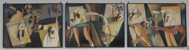
Artwork - Triptych, ‘Bits and Speechless Pieces’, ‘A Grimace on Obscurity 3’ and ‘Keeping the Interval’ by Tarli Glover, 1984
Tarli GLOVER Tarli Glover undertook a Bachelor of Arts at Ballarat College of Advanced Education [now Federation University] between 1980 and 1983, majoring in Fine Art Painting. Based in Central Victoria, she has been practicing professionally for over three decades and has exhibited widely throughout Australia. While Tarli's work covers a wide range of creative disciplines’ she concentrate’s primarily on painting, drawing and multi-media works with a focus on both landscape and figurative genres. Her work leans toward semi abstract symbolism and representation. This triptych was part of Tarli Glover's final year folio in 1983. This item is part of the Federation University Art Collection. The Art Collection features over 1000 works and was listed as a 'Ballarat Treasure' in 2007.A painted triptych by Tarli Glover with the following titles: .1) 'Bits and Speechless Pieces' .2) 'A Grimace on Obscurity' .3) 'Keeping the Interval'art, artwork, tarli glover, theatre, triptyc, oil on board, ballarat college of advanced education, alumni -
University of Melbourne, Burnley Campus Archives
Plan, Mark Burns, 3 Stage Therapy Garden Merve Irvine Nursing Home, 1996
Laminated and coloured Planting Plan by Mark Burns dated 07.10.1996, File No B33 Sheet No 3 of 4. Scale 1:100.mark burns, merve irving nursing home, landscape design, therapy garden, water features -
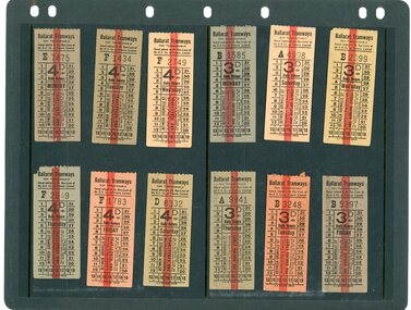 Ballarat Tramway Museum
Ephemera - Ticket, Electric Supply Co. of Vic (ESCo), Ballarat Tramways tickets - daily 3 pence - 4 pence, c19??
Daily return ticket issue for each day of the week to either Darling St (3d) or Sebastopol (4d). Was to be punched for the date of use, so as to prevent reuse on another day.Demonstrates a daily return ticket used in Ballarat.Assorted Ballarat Tramway tickets. The daily tickets, printed on colored paper, have a value between 3 pence and 4 pence. tickets, tramways, esco, ballarat tramways