Showing 5371 items
matching developing
-
 Ballarat Heritage Services
digital photographs, Manchester cathedral pamphlet, 2016
In the early middle ages the 'new town' of Manchester developed about a mile from the former Roman settlement of Castlefield. The Domesday Book (1086) records that within the Salford Hundred , Manchester had a church dedicated to St Mary. By the 13th centruy there was a stone church on the site by the de Gresle family whose crest is still used by the Manchester cathedral today. ... More information is contained within the pamphlet.4 Digital photographs, part of a pamphletmanchester, manchester cathedral, de gresle, england, domesday book -
 RMIT Design Archives
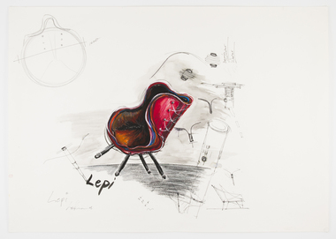
Work on paper - Design drawings, Sketch of Lepidoptera Chair or 'Lepi' winner of the 2009 Cecily and Colin Rigg Contemporary Design Award
The name of this chair, Lepidoptera, refers to the insect species of moths and butterflies as LeAmon drew upon the anatomy of a butterfly to develop the concept of the chair?s structure, colour and pattern. Another key feature of the design was the use of textile remnants from automotive textile manufacturer Autofab,recalling LeAmon's redeployment of leather offcuts from the manufacture of cricket balls to make her 'Bowling Arm' series of bangles.industrial design, furniture -
 Robin Boyd Foundation
Certificate, Honorary Fellowship to American Institute of Architects, 1960
By the late 1950s, Robin Boyd had developed a network of connections in the United States, and a reputation there as an important architectural critic. In 1960 he was awarded an Honorary Fellowship by the American Institute of Architects. This certificate is dated April 18, 1960, the day earlier than another certificate at Walsh Street (item D492). It is also signed by the President Philip Will Jr. 1960–1962 and the Secretary, Jeremy Leanne (?).Certificate from The American Institute of Architects, with crest, awarding Robin Boyd an Honorary Fellowship. Dated April 18, 1960 and signed by the President, Philip Will Jr, and Secretary Jeremy Leanne. It is inside an envelope.The American Institute of Architects certificate of Honorary Fellowship Robin Boyd eminent architect, citizen of Australia having been admitted to Honorary Fellowship by the Board of Directors in recognition of his distinguished achievements is declared to be an Honorary Fellow The American Institute of Architects entitled to use that title and to enjoy all the privileges of that membership.the american institute of architects, aia fellow, fellowship, robin boyd -
 Kew Historical Society Inc
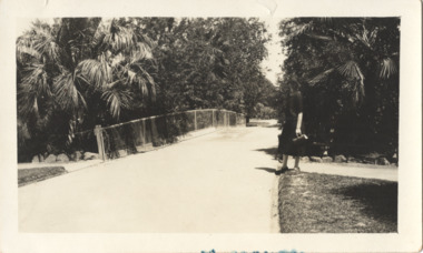
Photograph - In the 'Alexandra Gardens', Kew, 1927
The Alexandra Gardens in Cotham Road, Kew were opened by the Governor of Victoria in 1910. The first curator of the gardens was George Pockett, who with his brother is credited with the layout of the gardens. The gardens were constructed on land originally owned by the King family of 'Madford' in Wellington Street. The land on which the gardens were developed was originally the back paddock of 'Madford' which was purchased by the Borough of Kew in 1906.A rare and early photograph of the gardens showing clearly the changes to the layout and planting during the 1920s. Small, sepia coloured photographic positive of a woman standing beside a path and bridge in the Alexandra Gardens in Cotham Road, Kew.Annotation verso: "Alexandra Gardens Kew 1927"parks and gardens -- kew (vic.), alexandra gardens -- kew (vic.), george pockett -
 Kew Historical Society Inc
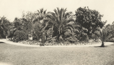
Photograph - In the 'Alexandra Gardens', Kew, 1927
The Alexandra Gardens in Cotham Road, Kew were opened by the Governor of Victoria in 1910. The first curator of the gardens was George Pockett, who with his brother is credited with the layout of the gardens. The gardens were constructed on land originally owned by the King family of 'Madford' in Wellington Street. The land on which the gardens were developed was originally the back paddock of 'Madford' which was purchased by the Borough of Kew in 1906.A rare and early photograph of the gardens showing clearly the changes to the layout and planting during the 1920s. Small, sepia coloured photographic positive of a woman with a suitcase standing on a gravel path in front of a semi-circular garden bed in the Alexandra Gardens in Cotham Road, Kew. The main plantings in the rock-bordered bed are varieties of palms. A wooden bridge can be seen to the woman's leftAnnotation verso: "Alexandra Gardens Kew 1927"parks and gardens -- kew (vic.), alexandra gardens -- kew (vic.), george pockett -
 Kew Historical Society Inc
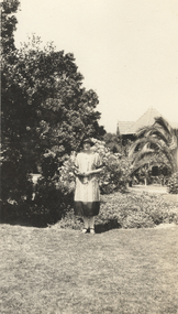
Photograph - In the 'Alexandra Gardens', Kew, 1927
The Alexandra Gardens in Cotham Road, Kew were opened by the Governor of Victoria in 1910. The first curator of the gardens was George Pockett, who with his brother is credited with the layout of the gardens. The gardens were constructed on land originally owned by the King family of 'Madford' in Wellington Street. The land on which the gardens were developed was originally the back paddock of 'Madford' which was purchased by the Borough of Kew in 1906.A rare and early photograph of the gardens showing clearly the changes to the layout and planting during the 1920s. Small, sepia coloured photographic positive of a woman standing on the grass in front of a garden bed in the Alexandra Gardens in Cotham Road, Kew. The Centennial Rotunda, built in 1910, can be seen in the background. Annotation verso: "Alexandra Gardens Kew 1927"parks and gardens -- kew (vic.), alexandra gardens -- kew (vic.), george pockett -
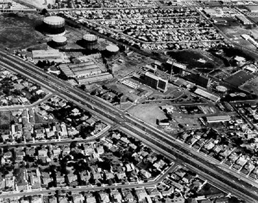 City of Kingston
Photograph - Black and white, c. 1970
The Highett Gas Works were a landmark along the Nepean Highway for many years. With the cessation of the gasification of coal and the introduction of natural gas to Victoria, the gas holders were demolished and the Sir William Fry Reserve was developed on the southern end of the site. The Gas and Fuel redeveloped the northern end of the site with modern offices and laboratories for the organisation's scientific services. At this time, the chimney and retort house were retained.The Highett Gasworks had its beginning in 1939 operated by the Central Brighton and Moorabbin Gas Co Ltd. The company had expanded its gas production facilities to Highett where it had purchased 45 acres of land adjacent to the Melbourne-Frankston railway line. The first gasholder was erected on the Highett site in 1927 and connected with high pressure mains to the Brighton Gas Works. In 1939 the building program including gasometers, the vertical retort house and coal store was completed and gas making commenced. Its area of supply covered approximately 70 square miles and included the municipalities of Brighton, Sandringham, Moorabbin, Mordialloc, Chelsea and part of Dandenong. The Gas and Fuel Corporation eventually took over operations and with the disaggregation and privatisation of the organisation, the site was eventually closed c. 2002.Black and white aerial photograph featuring the Highett Gas Works with gasholders and retort house. In the top right-hand corner, a former Highett Primary School on Graham Road can be viewed. Photograph includes Bay Road, Royal Avenue, Princess Avenue and Jackson Road (Highett) and Alfred, Turner and Sandford Streets (Moorabbin).Handwritten in black ink: [indecipherable] in a circle Handwritten in red ink: 70% Four velcro display adhesivesgasification of coal, gas and fuel corporation of victoria, gasholders, highett, moorabbin, utilities -
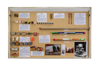 Department of Energy, Environment and Climate Action
Incendiaries (various)
Incendiaries used for planned burning operations All kind of pyrotechnics have been developed over the years from “strike anywhere” wax vestas, safety fusees, large DAIDs, burning tyres dragged behind vehicles, humble drip torches, incendiary shotguns and mortars, flame throwers of various designs, blow torches, jellied petrol blivets wired up to electrical circuits Display table that includes various type of incendiaries including windproof matches, Fusse matches, self propelled incendiary flares, incendiary capsules, vials and balls, Delayed Action Incendiary Devices (DAIDS), Gun Operated Flares (GOF)forests commission victoria (fcv), bushfire, planned burning -
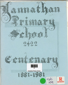 Narre Warren and District Family History Group
Book, Debra A Crowley, Yannathan Primary School 2422- Centenary 1881 - 1981, 1981
An account of the early history of Yannathan and the development of Yannathan School No. 2422. Lists original selectors, teachers, first committee members of the Yannathan Recreation Reserve and the Yannathan Hall. Also lists Yannathan's fallen war heroes.36 p.; 21 cmnon-fictionAn account of the early history of Yannathan and the development of Yannathan School No. 2422. Lists original selectors, teachers, first committee members of the Yannathan Recreation Reserve and the Yannathan Hall. Also lists Yannathan's fallen war heroes.yannathan (vic.), yannathan primary school no. 2422, yannathan (vic.) -- history -
 Bendigo Historical Society Inc.
Document - DOCUMENTS RELATING TO: THE BENDIGO AND DISTRICT TOURIST ASSOCIATION, July 7th, 1970
Various documents relating to the Bendigo and District Tourist Association. Includes Minutes of five meetings of the Board (1970/1971); Notice of AGM 1969; Annual Report 1971; Articles of Association (as amended 14/9/1971); single page headed ''Development of Nell Gwynne and Victoria Hill Sites'' - extensive plans for a 'tourist site with museum, cemetery, chapple (sic), rotunda. Theatre, façade of Charing Cross, a flying-fox from Nell Gwynne to Victoria Hill (no date); Mining Sub-Committee Report and Recommendation (Tourist Development Committee) 1967 re Resolution that ''Quartz Hill'' be developed as a mining tourist attraction (details provided ($75.000 est.); Draft Proposals for Brochure (authored by Miles Lewis, Carlton) - brochure to promote the idea of a museum and tourist development at the Nell Gwynne site; letter to Bendigo businesses re seeking funds for tourist development - Daryl McClure, Hon Sec June 1970.;bendigo, tourism, bendigo and district tourist association -
 NMIT (Northern Melbourne Institute of TAFE)
Book: Melbourne’s North – the new knowledge economy Melbourne’s North – the new knowledge economy 2009
Melbourne’s North – the new knowledge economy is a study commissioned by NORTH Link and the Northern Metropolitan Melbourne Area Consultative Sub-Committee with seed funding from the Victorian Government Department of Innovation, Industry and Regional Development and matching funding from industry, education and local government in Melbourne’s North. It was prepared by National Institute of Economic and Industry Research. The report provides a detailed analysis of the Melbourne’s North regional economy and builds on the previous report, Growing Melbourne’s North – developing an integrated economy. It concludes that the region can achieve significant economic and social benefits if stakeholders share resources and cooperate across local government boundaries to form a discrete economic zone. The report includes recommendations and benchmarks that will support growth and quality employment outcomes for the region into the future as it undergoes the transition into a knowledge economy. Consultants National Institute of Economic and Industry Research (NIEIR), Carmine Consulting ISBN 978-0-9803994-4-3 northern melbourne region, nmit -
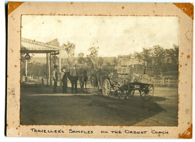 Orbost & District Historical Society
black and white photograph, C 1890s
The photograph shows the Royal Mail wagon outside Herbert's General Store in the main street of Orbost. Lancelot Herbert came to Orbost in 1886, taking up a partnership with local store-owner George Temple. After Mr Temple’s death in 1891, Lancelot took over the store and progressively developed Herberts Snowy River Stores which grew into a department store of several shops along Nicholson StThis is a pictorial record of transport in 19th century Orbost. It is associated with the Herbert family.A black / white photograph of a travelling salesman and his samples on the Orbost Coach outside Herbert's grocery store. Two other men are standing nearby. The photograph is on a cream buff card.on front - "Traveller's Samples on Orbost Coach"herbert's-store transport -
 Bendigo Military Museum
Letter - Army Survey Regiment - Letter of request for additional computer disk space for Automap 2, Army Survey Regiment, 19 Feb 1987
Automap 2 was the Army Survey Regiment's computerized Mapping system. This letter is a request for an additional 700 Mb of computer disk space for the Automap 2 System because of newly developed applications. Those applications were: Analytical Hill shading, Digital Terrain Modelling, Mask and stipple Production, RAAF Chart symbol Placement, ASTIS - Army Survey - Topographic Information System, and, Map Catalog Production.Two page letter, foolscap size, Stapled top left corner"A Spurling, Computer Operations Manager for CO"royal australian survey corps, rasvy, fortuna, army survey regiment, army svy regt, asr -
 Warrnambool and District Historical Society Inc.
Polaroid Camera, 1980s
The polaroid camera was first produced in Massachusetts, U.S.A. in 1937 by Edwin Land. He developed the concept of instant photography following his production of polarized sunglasses. This Sun 660 model was first produced in 1981. Polaroid cameras were very popular in the 1970s and 80s. The Polaroid Company was re-formed several times and sold to The Impossible Project Company in 2017. Instant cameras can still be purchased today. This camera has no known local provenance but is retained for display purposes.This is a Polaroid brand instant camera enclosed in a black case. It has a cloth strap with plastic attachments. It features sonar autofocus technology.Polaroid Sun 660 Autofocus -
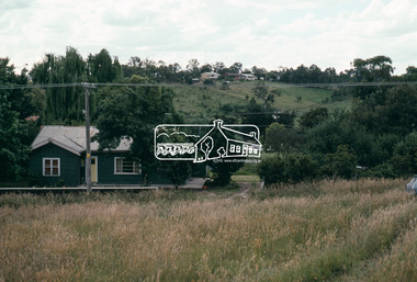
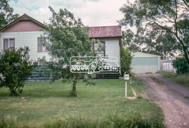
 Eltham District Historical Society Inc
Photograph, Vacant Lot, 57 Park Road, Eltham, Dec. 1980
Roll of film taken by Eltham Shire Council officers of roads and houses in the Eltham East area in December 1980. They provide perspective of the changes in housing styles and road development that began sweeping in from the mid 1970s with increasing urbanisation of what was once more outlying suburbs and regions. Typically part of the Beard street group, a private street scheme that developed the road infrastructure commencing in February 1982.35mm colour positive transparency Mount - Kodak Kodachrome Cardeltham, housing estate, infrastructure, park road, roads -
 Eltham District Historical Society Inc
Photograph, 53 Park Road, Eltham, Dec. 1980
Roll of film taken by Eltham Shire Council officers of roads and houses in the Eltham East area in December 1980. They provide perspective of the changes in housing styles and road development that began sweeping in from the mid 1970s with increasing urbanisation of what was once more outlying suburbs and regions. Typically part of the Beard street group, a private street scheme that developed the road infrastructure commencing in February 1982.35mm colour positive transparency Mount - Kodak Kodachrome Cardeltham, housing estate, infrastructure, park road, roads -
 Eltham District Historical Society Inc
Photograph, 85 Park Road, Eltham, Dec. 1980
Roll of film taken by Eltham Shire Council officers of roads and houses in the Eltham East area in December 1980. They provide perspective of the changes in housing styles and road development that began sweeping in from the mid 1970s with increasing urbanisation of what was once more outlying suburbs and regions. Typically part of the Beard street group, a private street scheme that developed the road infrastructure commencing in February 1982.35mm colour positive transparency Mount - Kodak Kodachrome Cardeltham, housing estate, infrastructure, park road, roads -
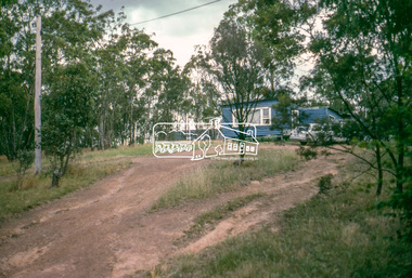
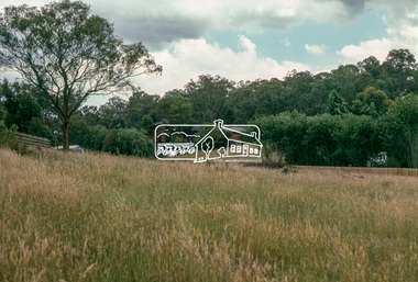 Eltham District Historical Society Inc
Photograph, Undeveloped land, Beard Street, Eltham, Dec. 1980
Roll of film taken by Eltham Shire Council officers of roads and houses in the Eltham East area in December 1980. They provide perspective of the changes in housing styles and road development that began sweeping in from the mid 1970s with increasing urbanisation of what was once more outlying suburbs and regions. Typically part of the Beard street group, a private street scheme that developed the road infrastructure commencing in February 1982.35mm colour positive transparency Mount - Kodak Kodachrome Cardeltham, housing estate, infrastructure, roads, andrews street, beard street -
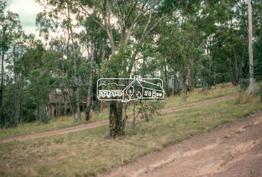
 Eltham District Historical Society Inc
Photograph, Andrews Street, Eltham, Dec. 1980
Roll of film taken by Eltham Shire Council officers of roads and houses in the Eltham East area in December 1980. They provide perspective of the changes in housing styles and road development that began sweeping in from the mid 1970s with increasing urbanisation of what was once more outlying suburbs and regions. Typically part of the Beard street group, a private street scheme that developed the road infrastructure commencing in February 1982.35mm colour positive transparency Mount - Kodak Kodachrome Cardeltham, housing estate, infrastructure, roads, andrews street -
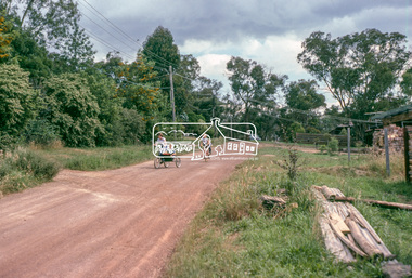
 Eltham District Historical Society Inc
Photograph, Frank Street, Eltham, Dec. 1980
Roll of film taken by Eltham Shire Council officers of roads and houses in the Eltham East area in December 1980. They provide perspective of the changes in housing styles and road development that began sweeping in from the mid 1970s with increasing urbanisation of what was once more outlying suburbs and regions. Typically part of the Beard street group, a private street scheme that developed the road infrastructure commencing in February 1982.35mm colour positive transparency Mount - Kodak Kodachrome Cardeltham, housing estate, infrastructure, roads, frank street -
 Eltham District Historical Society Inc
Photograph, Frank Street, Eltham, Dec. 1980
Roll of film taken by Eltham Shire Council officers of roads and houses in the Eltham East area in December 1980. They provide perspective of the changes in housing styles and road development that began sweeping in from the mid 1970s with increasing urbanisation of what was once more outlying suburbs and regions. Typically part of the Beard street group, a private street scheme that developed the road infrastructure commencing in February 1982.35mm colour positive transparency Mount - Kodak Kodachrome Cardeltham, housing estate, infrastructure, roads, frank street, beard street -
 Eltham District Historical Society Inc
Photograph, Frank Street, Eltham, Dec. 1980
Roll of film taken by Eltham Shire Council officers of roads and houses in the Eltham East area in December 1980. They provide perspective of the changes in housing styles and road development that began sweeping in from the mid 1970s with increasing urbanisation of what was once more outlying suburbs and regions. Typically part of the Beard street group, a private street scheme that developed the road infrastructure commencing in February 1982.35mm colour positive transparency Mount - Kodak Kodachrome Cardeltham, housing estate, infrastructure, roads, frank street -
 Eltham District Historical Society Inc
Photograph, Shalbury Avenue, Eltham, Dec. 1980
Roll of film taken by Eltham Shire Council officers of roads and houses in the Eltham East area in December 1980. They provide perspective of the changes in housing styles and road development that began sweeping in from the mid 1970s with increasing urbanisation of what was once more outlying suburbs and regions. Typically part of the Beard street group, a private street scheme that developed the road infrastructure commencing in February 1982.35mm colour positive transparency Mount - Kodak Kodachrome Cardeltham, housing estate, infrastructure, roads, shalbury avenue -
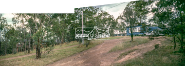 Eltham District Historical Society Inc
Photograph, Shalbury Avenue, Eltham, Dec. 1980
Roll of film taken by Eltham Shire Council officers of roads and houses in the Eltham East area in December 1980. They provide perspective of the changes in housing styles and road development that began sweeping in from the mid 1970s with increasing urbanisation of what was once more outlying suburbs and regions. Typically part of the Beard street group, a private street scheme that developed the road infrastructure commencing in February 1982.Born digital based on two 35mm colour positive transparencies converged into a panormaeltham, housing estate, infrastructure, roads, shalbury avenue -
 Eltham District Historical Society Inc
Photograph, Shalbury Avenue, Eltham, Dec. 1980
Roll of film taken by Eltham Shire Council officers of roads and houses in the Eltham East area in December 1980. They provide perspective of the changes in housing styles and road development that began sweeping in from the mid 1970s with increasing urbanisation of what was once more outlying suburbs and regions. Typically part of the Beard street group, a private street scheme that developed the road infrastructure commencing in February 1982.35mm colour positive transparency Mount - Kodak Kodachrome Cardeltham, housing estate, infrastructure, roads, shalbury avenue