Showing 3783 items
matching historical society report
-
 Eltham District Historical Society Inc
Photograph, Murchison Gap, Autumn Excursion, Hume and Hovell's 1824 expedition, 26 May 1996, 26/05/1996
[article by Bettina Woodburn in EDHS Newsletter No. 109, July 1996:] ON THE TRAIL OF HUME AND HOVELL - REPORT ON THE AUTUMN EXCURSION - On a green and fresh morning (Sunday 26th May 1996) the Cobb and Co coach (driven by the most obliging Peter Tampion) set off in a north easterly direction from Eltham to connect with Hume and Hovell's route on their 1824 explorations of central Victoria. The Society would follow a series of monuments erected for the 1924 centenary of the expedition from King Parrot Creek (Tuesday 7th December 1824), through Strath Creek, over Sunday Creek (Sunday 12th December 1824) at Broadford, Tullamarine, St Albans, Deer Park, through Werribee, skirting east of the You Yangs to Lara and Avalon Beach. Because their distance-measuring wheel had broken and a one degree mistake was made in calculations, the two leaders of the original group of six convict-companions arrived at Corio Bay, instead of the expected Western Port, discovered earlier by Flinders. From below Mt. Disappointment (Hume and Hovell's difficulties in "scrambling over brush and rock", "leeches in forest, as well as no water", "cutting grass 4-5 ft. high", dreadful scrub", "devil flies") we took an easier route, saw the Strath Creek memorial in ground fog and a wonderful "field of dreams", the Hume-Hovell privately owned cricket ground with its white picket boundary fence. Now, after a steep climb, in sunshine under gums we stretched and viewed magnificent rolling hills and fog-filled valleys - not "smoke from Aborigines' bush fires". After morning tea at Broadford we followed the Sunday Creek valley beside the Hume Freeway, passed the Wallan Wallan Rest Area (more appropriately Hume and Hovell Rest Area) to tum right at Beveridge. In Gellibrand Hill Park, near the headwaters of the Moonee Ponds Creek, we experienced the landscape the first European settlers saw - huge river red gums and rolling pastures. The gardens and sheltered courtyard of the 1840s, timber, brought from .....[?] prefabricated Woodlands Homestead, provided a pleasant lunch stop. We enjoyed a private tour, panoramic views over Melbourne and surroundings and the excitement of arriving and departing aircraft. Our next river crossing was at Werribee, "in a vast treeless plain", then we drove on by-ways no coach had previously travelled, to find "an immense sheet of water" salty Corio Bay, off-course to the west. In late afternoon of a super, calm, late autumn day we headed homewards. Back at Eltham we were rather surprised to find that we had travelled a total of 347 km. Thanks again to Russell Yeoman for his research and organization. What a wonderful day! Three colour photographsactivities, murchison gap, murchison valley -
 Eltham District Historical Society Inc
Photograph, Hume and Hovell Monument, Broadford, Autumn Excursion, Hume and Hovell's 1824 expedition, 26 May 1996, 26/05/1996
[article by Bettina Woodburn in EDHS Newsletter No. 109, July 1996:] ON THE TRAIL OF HUME AND HOVELL - REPORT ON THE AUTUMN EXCURSION - On a green and fresh morning (Sunday 26th May 1996) the Cobb and Co coach (driven by the most obliging Peter Tampion) set off in a north easterly direction from Eltham to connect with Hume and Hovell's route on their 1824 explorations of central Victoria. The Society would follow a series of monuments erected for the 1924 centenary of the expedition from King Parrot Creek (Tuesday 7th December 1824), through Strath Creek, over Sunday Creek (Sunday 12th December 1824) at Broadford, Tullamarine, St Albans, Deer Park, through Werribee, skirting east of the You Yangs to Lara and Avalon Beach. Because their distance-measuring wheel had broken and a one degree mistake was made in calculations, the two leaders of the original group of six convict-companions arrived at Corio Bay, instead of the expected Western Port, discovered earlier by Flinders. From below Mt. Disappointment (Hume and Hovell's difficulties in "scrambling over brush and rock", "leeches in forest, as well as no water", "cutting grass 4-5 ft. high", dreadful scrub", "devil flies") we took an easier route, saw the Strath Creek memorial in ground fog and a wonderful "field of dreams", the Hume-Hovell privately owned cricket ground with its white picket boundary fence. Now, after a steep climb, in sunshine under gums we stretched and viewed magnificent rolling hills and fog-filled valleys - not "smoke from Aborigines' bush fires". After morning tea at Broadford we followed the Sunday Creek valley beside the Hume Freeway, passed the Wallan Wallan Rest Area (more appropriately Hume and Hovell Rest Area) to tum right at Beveridge. In Gellibrand Hill Park, near the headwaters of the Moonee Ponds Creek, we experienced the landscape the first European settlers saw - huge river red gums and rolling pastures. The gardens and sheltered courtyard of the 1840s, timber, brought from .....[?] prefabricated Woodlands Homestead, provided a pleasant lunch stop. We enjoyed a private tour, panoramic views over Melbourne and surroundings and the excitement of arriving and departing aircraft. Our next river crossing was at Werribee, "in a vast treeless plain", then we drove on by-ways no coach had previously travelled, to find "an immense sheet of water" salty Corio Bay, off-course to the west. In late afternoon of a super, calm, late autumn day we headed homewards. Back at Eltham we were rather surprised to find that we had travelled a total of 347 km. Thanks again to Russell Yeoman for his research and organization. What a wonderful day! Colour photographactivities, broadford, hume and hovell, monument -
 Eltham District Historical Society Inc
Photograph, Hume and Hovell Monument, Autumn Excursion, Hume and Hovell's 1824 expedition, 26 May 1996, 26/05/1996
[article by Bettina Woodburn in EDHS Newsletter No. 109, July 1996:] ON THE TRAIL OF HUME AND HOVELL - REPORT ON THE AUTUMN EXCURSION - On a green and fresh morning (Sunday 26th May 1996) the Cobb and Co coach (driven by the most obliging Peter Tampion) set off in a north easterly direction from Eltham to connect with Hume and Hovell's route on their 1824 explorations of central Victoria. The Society would follow a series of monuments erected for the 1924 centenary of the expedition from King Parrot Creek (Tuesday 7th December 1824), through Strath Creek, over Sunday Creek (Sunday 12th December 1824) at Broadford, Tullamarine, St Albans, Deer Park, through Werribee, skirting east of the You Yangs to Lara and Avalon Beach. Because their distance-measuring wheel had broken and a one degree mistake was made in calculations, the two leaders of the original group of six convict-companions arrived at Corio Bay, instead of the expected Western Port, discovered earlier by Flinders. From below Mt. Disappointment (Hume and Hovell's difficulties in "scrambling over brush and rock", "leeches in forest, as well as no water", "cutting grass 4-5 ft. high", dreadful scrub", "devil flies") we took an easier route, saw the Strath Creek memorial in ground fog and a wonderful "field of dreams", the Hume-Hovell privately owned cricket ground with its white picket boundary fence. Now, after a steep climb, in sunshine under gums we stretched and viewed magnificent rolling hills and fog-filled valleys - not "smoke from Aborigines' bush fires". After morning tea at Broadford we followed the Sunday Creek valley beside the Hume Freeway, passed the Wallan Wallan Rest Area (more appropriately Hume and Hovell Rest Area) to tum right at Beveridge. In Gellibrand Hill Park, near the headwaters of the Moonee Ponds Creek, we experienced the landscape the first European settlers saw - huge river red gums and rolling pastures. The gardens and sheltered courtyard of the 1840s, timber, brought from .....[?] prefabricated Woodlands Homestead, provided a pleasant lunch stop. We enjoyed a private tour, panoramic views over Melbourne and surroundings and the excitement of arriving and departing aircraft. Our next river crossing was at Werribee, "in a vast treeless plain", then we drove on by-ways no coach had previously travelled, to find "an immense sheet of water" salty Corio Bay, off-course to the west. In late afternoon of a super, calm, late autumn day we headed homewards. Back at Eltham we were rather surprised to find that we had travelled a total of 347 km. Thanks again to Russell Yeoman for his research and organization. What a wonderful day! Two colour photographsactivities, hume and hovell, monument -
 Eltham District Historical Society Inc
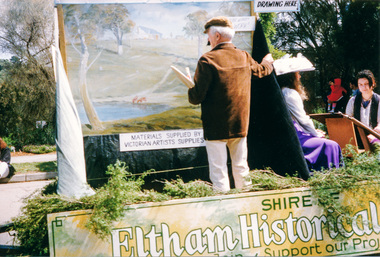
Photograph, Getting ready for the parade, Diamond Street, Eltham Festival, 10 November 1990, 10/11/1990
[from a contemporary report:] The festival parade was held at 11.00 am on Saturday, 10 November 1990, commencing in Youth Road (behind Eltham Railway Station) and Diamond Street. As per tradition, the Shire of Eltham Historical Society entered a float in the parade but for the first time combined with the Diamond Valley Arts Society to produce the float. The theme of the parade was ''Spring into Summer". In accordance with this theme the Society's float depicted artists on a spring painting excursion. Part of the group was "Walter Withers" painting a landscape. There was also another artist painting a portrait of a girl in a spring costume. Joh Ebeli was responsible for preparation of the float. The float won the prize for the best display. Originally contained in a 'magnetic' photo album believed to have been donated by Mr Eric Stephenson, Jingalong, 110 Ryans Road, Eltham, Vic. 3095; relocated to archival safe storage.Colour photograph1990, eltham festival, diamond street, diamond valley arts society, joh ebeli, parade, parade floats, walter withers, youth road -
 Eltham District Historical Society Inc
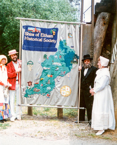
Photograph, Russell Yeoman (left) and Joh Ebeli hold the Society Banner at the end of the Parade in Panther Place near the Railway Trestle Bridge, Eltham Community Festival Parade, 8 November 1986, 08/11/1986
[from a contemporary report:] The Shire of Eltham Historical Society's entry in the 1986 Eltham Community Festival Parade included Ben Hall's Cobb & Co. coach along with several vintage motor vehicles and the Society's new Community Banner. Members dressed in in an appropriate costume to ride in one of the vehicles or walk along with them. The assembly point was in Cecil St. at 11.45 a.m. The Society's entry was awarded the major prize for the parade.Colour photographeltham festival, shire of eltham historical society, 1986, russell yeoman, trestle bridge, joh ebeli -
 Orbost & District Historical Society
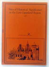
Booklet - book, Booklet, softcover, Sites of Historical Significance in the East Gippsland Region, October 1980
This is the second report by the East Gippsland Regional Planning Committees part of the Regional Studied Program in East Gippsland requested by Mrs Marion Le Cheminant.This is a useful reference tool. It documents sites of significance, including the Orbost area of East Gippsland.A stapled book with a brown/orange cover. On the front cover is a black print hand-drawn illustration of some buildings (possibly Bairnsdale Courthouse. The title, "Sites of Historical Significance in the East Gippsland Region", is in black print at the top. This is inside a black border.Sites of Historical Significance / in the East Gippsland Region / EAST GISPPSLAND REGIONAL PLANNING COMMITTEEhistoric sites, history, east gippsland, heritage -
 Orbost & District Historical Society
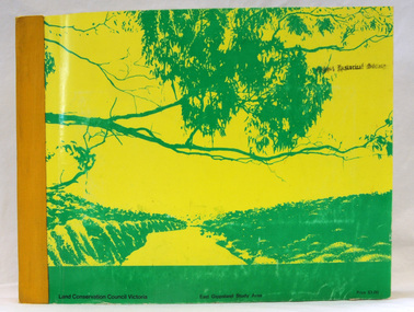
book, Report on the East Gippsland Study Area, June 1974
In 1961 Bruce Evans was elected to the Victorian Legislative Assembly as the member for Gippsland East. He was the party's deputy leader from 1964 to 1970 and its whip from 1970 until his retirement in 1992. "The Land Conservation Council was established by the Land Conservation Act 1970. As one of its three functions, it makes recommendations to the Minister for Planning and Environment with respect to the use of public land, in order to provide for the balanced use of land in Victoria. This report contains the Council’s final recommendations concerning the use of public land in the East Gippsland study area, the boundaries of which correspond to those of the Shire of Orbost. The recommendations in the text are grouped under major headings, such as Parks, State Forest, and so on. " The Council met on seven occasions during the year, and also made visits of inspection to each study area. The Chairman visited Shire Councils in study areas to explain the role and the functions of the Land Conservation Council and to invite submissions on the use of public land in these areas. This is the fourth annual report by the council. This is a useful research tool.A large book 236 pp book with a yellow / gold cover with a green bush scene . The binding is orange. It contains folded maps and information on public land use in East Gippsland.inside - "With Compliments - Bruce Evans, M.P."east-gippsland-study-area conservation public-land-use -
 Orbost & District Historical Society
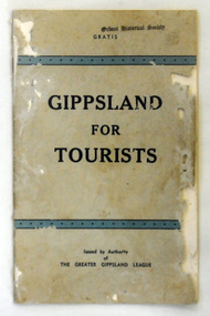
book, Gippsland For Tourists, 1938
This is the 2nd edition. In the Gippsland Times newspaper on June 1 1936 there is a report of a meeting of the Greater Gippsland League at which the production of this book was mentioned as"a method of marking the Gippsland Centenary. TOURIST BOOK-LET. The work of -Messrs A. Gilchrist and A. B. Cooper in connection with the preparation of a tourist booklet was warmly commended and a minute of appreciation placed on record." This group seems to have been a group of Gippsland citizens interested in the progress of Gippsland and any government action in the area. This meeting was held at Maffra. This tourist guide is a contemporary record of tourism promotion in Gippsland.A thin 48 pp booklet with a grey cover. The title, "GIPPSLAND FOR TOURISTS" is inside two blue, black bordered, bands. The print is navy. ath efoot of the page is "Issued by Authority of the Greater Gippsland League". At the top is "Gratis". at top of front cover - "Orbost Historical Society" stampedgippsland-tourism greater-gippsland-league -
 Orbost & District Historical Society
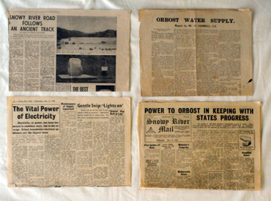
newspaper clippings, 1962
Collected by Mary Gilbert. This folder belonged to Mary Gilbert and was probably used by her whilst teaching at Orbost High School and as a member of the Orbost Historical Society. Mary Isabelle Gilbert was born in 1905 in Orbost, Australia. She was born to John Gilbert and Annie Cameron Gilbert, and had seven sisters and one brother. Four siblings died at a young age. .She was a teacher historian loved and respected by her family and the wider community. This item is a useful research tool.A manila folder containing b/w newspaper cuttings relating to the progress of Orbost power, mail and water supply. The articles are from various newspapers.. 732.2 is a report by Mr A. Sambell. C.E. on the Orbost Water Supply. 732.3 is from the Weekly Times, July 17 1968 and is titled "Snowy River Mail Follows Our Ancient Track". 732.4 is from the Snowy River Mail, May 16 1962 and is titled " Power To Orbost in Keeping with State's Progress. 732.5 is from the Snowy River Mail, May 16 1962 and is titled " The Vital Power of Electricity".orbost-power-water-supply -
 Orbost & District Historical Society
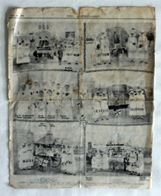
newspaper cutting, June 22 1918
This article reports on a "gymkhana held at Orbost in aid of the Red Cross and kindred institutions by which £2000 was realised from a population of 22000 adults and children. The expenses were practically nil." The Australasian was published every Saturday in a tabloid newspaper format. It contained extensive pictorial coverage of the week's events. The Australasian gave an insight into the life and times of Australians from week to week. News from Australia, New Zealand and abroad was presented. The Australian Red Cross Society (ARCS) was formed just after the outbreak of the First World War in August 1914, originally as a branch of the the British Red Cross. This is a contemporary record of a significant event in Orbost. It reflects the involvement of Orbost, a small town, in the efforts of the Australian Red Cross Society to provide comforts to soldiers during World war 1.A single page cutting from the Australasian. It has black / white photographs of local red cross workers at an Orbost Gymkhana. There are photos of a jumble stall, flower sellers. a fruit cart and a display of soldiers' comforts. 738.2 is a photocopy of the original.In black - names - Evelyn Blacklock, Leila Perry, Grace & Nell Cameron, Jane Cameron, Florrie Cameron, Annie Stirling, Jean Stirling, Lily Perry, Marion Gilbert, Grace Cameronww1 australasian-newspaper red-cross-orbost -
 Orbost & District Historical Society
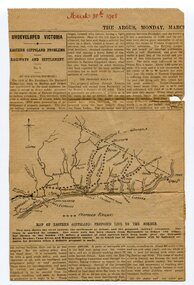
newspaper clippings, 1908; 1958; 1970
These articles were compiled by Mary Gilbert.They have been cut from The Argus, The Age and the Snowy River Mail.These articles are contemporary reports on the transport system in Orbost and as such are useful research tools.A manila folder containing black / white newspaper clippings from various newspapers. The articles are related to transport in Orbost - rail and shipping. (details in Catalogue 735 - 900) -
 Orbost & District Historical Society
newspaper clippings, mid 20th century
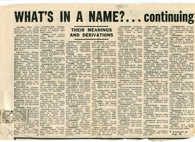
These articles were collated by Mary Gilbert. Mary Isabelle Gilbert was born in 1905 in Orbost, Australia. She was born to John Gilbert and Annie Cameron Gilbert, and had seven sisters and one brother. Four siblings died at a young age. .She was a teacher historian loved and respected by her family and the wider community.These articles are contemporary reports of prominent Orbost identities and are a useful reference tool.A manila folder containing newspaper articles of local identities. 745.1 is titled,"What's In a Name? Their Meanings and Derivations". 745.2 is from the Weekly Times, February 23, 1955, page 25 and is titled, "Orbost Women Who Are Well-Known". 745.3 is from the Weekly Times, May2, 1951, Page 5 and is titled, " People of Orbost (Vic)". 745.4 is from the Snowy River Mail and is titled, "Vale: Richard Forsythe Beattie: Came to Orbost Over 80 Yrs Ago". On the back is an article titled, " Report of Death of Mr George Seymour Luckins". 745.5 is titled, " Happy Family Life is Answer - Harold (79) and Olive (78) Sheffield. It is a black and white photograph. 745.6 is titled, "Tubbut and the Whittakers".beattie-richard-forsythe luckins-george-seymour sheffield-harold whittakers-tubbut -
 Ringwood and District Historical Society
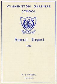
Document - Packet, Winnington Grammar School - letters, reports, handwritten history, newspaper clippings 1924 - 1961, 1916-1961
Packet / pdf file : Winnington Grammar School letters, printed matter, articles, Newspaper articles, annual report 1949. Dqates range from 1924 to 1947 and include brief history of the school. +Additional Keywords: Pearson, Cr. H.F., Mayor of Ringwood 1949 Annual Report hardcopy is filed separately as VC 11107 but is still included in this pdf. (Microfiched then converted to pdf #4043) -
 Ringwood and District Historical Society
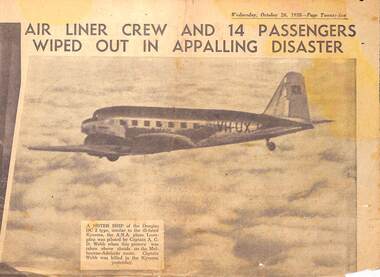
Newspaper - clipping, The Sun News Pictorial, DC2 Kyeema crashed into Mt Dandenong. Crew and 14 passengers killed, 25-Oct-38
The Sun News Pictorial newspaper reports of aircraft disaster. -
 Ringwood and District Historical Society
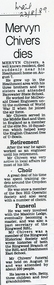
Newspaper cutting, The Mail, Article from the Mail reporting the death of well known resident Mervyn Chivers 7 August 1989, Aug-89
Mervyn Chivers dies. Article in 'The Mail' 23-Aug-1989 .Mervyn joined the air force in WW2 and served in the Middle East and England. He was a well known resident with interests in the Box Hill Operatic Society and sang in many choirs. He was also involved with the Masonic Lodge and was Secretary of the Ringwood RSL. As a member of the Historical Society wrote histories of both the Ringwood RSL and HeathmontPhotocopy of article from the Mail 23-Aug-1989 noting Mervyn Chivers death and his community involvement. +Additional Keywords: Chivers, Mervyn -
 Ringwood and District Historical Society
Letter, Police Report - Boys swimming in Ringwood Lake 1938, 21-Nov-38
Letter detailing the incident of four boys caught swimming in the lake which was not permitted. The boys were aged between 10 and 14 and it was a hot day.Police report concerning boys swimming in the Ringwood Lake +Additional Keywords: Dawson, Henry / Loone, Ralph / Loone, Alfred / Carvill, David -
 Ringwood and District Historical Society
Document, Short history of Nunawading, c 1950
This report covers some of the eastern suburbs of Melbourne from 1834 to 1890 (approx). The early settlement of Nunawading, agricultural development, industries, residential development, institutions and hotels. Place names , churches and schools are also included4 pages of typed notes of the short history of Nunawading between 1834 and 1890 (approx) +Additional Keywords: Holland, Clisby, Williams, Riles, Polak,Schwerkolt, Smith, Rooks, Boyle, Sergeant, Matters, Ainger, Slater -
 Ringwood and District Historical Society
Reports of Scout meetings, Scout Association of Australia, Scout Association of Australia. Ringwood District Meetings 1964-1979, 1976 - 1978
Scout Association of Australia. Ringwood District Meetings.; 1. Ringwood D.A. Meetings Mar-1964 - May 1977; 2. Ditto Jan-1974 - Jul-1976; 3. Ditto Aug-1976 - Apr-1978; 4. Ditto May-1978 - May-1979; 5. Ditto Jun-1979-...Ringwood D.A. Meetings -
Ringwood and District Historical Society
Ephemera, Ringwood Mail, Ringwood Elderly Citizens' Clubrooms opening 1964 - Printer's Block, 2-May-64
Printers Block of two people standing by a plaque under a picture. Text on rear of block is as follows: For report see 9th May[19] '64. Official opening Elderly Citizens clubrooms 2nd May 1964. Mayoress Mrs P. Vergers unveils plaque. Town Clerk Mrs F.P. Dwerryhouse looks on. Ringwood Mail 14.5.[19]64. +Additional Keywords: Vergers, Mrs P / Dwerryhouse -
Ringwood and District Historical Society
Reports to Ratepayers, Whitehorse Press, Ringwood Council's Annual Reports to the ratepayers 1956, 1959, 1960, c. 1956-1960
Ringwood Council's Annual Report to the ratepayers. Three copies dated Jan 1956, Dec-1959 and Dec-1960. Each 8pp. -
Ringwood and District Historical Society
Report, Ringwood East Primary School, Ringwood East Primary School Parents Club: Documents re Toilet Facilities 1970's, 1970s
2 typed pages for Ringwood East Primary School No.4180 about toilet facilities; See also Box 01-03-02 Box 1 working committee papers. -
Ringwood and District Historical Society
Report, Ringwood East Primary School: Booklet recording school work and reports, Grade 4. undated but pre-1993, pre 1993
Blue covered booklet with 8 yellow pages inside with printing and sketches to record school work and report Grade 4 Ringwood East Primary School 4180 proforma -
Ringwood and District Historical Society
Report, Ringwood Primary School - Review Panel Report June 1987, Jun-87
The report contains school review seen as a channel for gaining independent opinion on the school's performance. Also included is a parent participation review, parent survey and responses, and a functioning & climate survey.Blue covered document with black spinex binding containing typed report of the Review Panel of Ringwood Primary School - June 1987 -
 Ringwood and District Historical Society
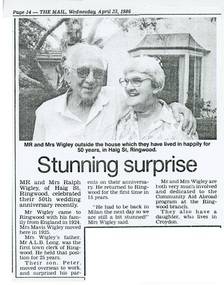
Newspaper - Clipping, 50th wedding anniversary of Ralph and Mavis Wigley, Haig Street Ringwood (Victoria) - 1986
Photograph and report from The Mail (Ringwood) Newspaper, April 23, 1986. Mrs Wigley was the daughter of Mr A.F.G. Long, first Town Clerk of Ringwood, 1925-1950. -
Ringwood and District Historical Society
Envelope, Packet: Ringwood Thrip Investigation League Report 1932, c.1932
Thrip - Letter and report from the Victorian Fruit Marketing Assoc. +Additional Keywords: Miles / Aird -
Ringwood and District Historical Society
Report, The Early History of Warrandyte, by W.W.L. Radden 11-Nov-1965, Nov-65
11 foolscap pages - The Early History of Warrandyte, prepared by W.W.L. Radden 11-Nov-1965, includes extensive references. +Additional Keywords: Radden, W.W.L. -
 Ringwood and District Historical Society
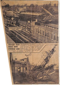
Newspaper - Clippings, Derailment at Ringwood Railway Station, Victoria - 1945
Newspaper reports with view of derailment at Ringwood Railway Station, dog box carriage in foreground, two carriages also derailed appear to be later models. Incident date Friday 22 June, 1945. -
Ringwood and District Historical Society
Annual Report, Ringwood RSL Annual Report and Financial Statement 1978, 27-Feb-79
Copy provided by Derek F. Snowball, Secretary.Ringwood Sub-branch, Returned Services League Annual Report and Financial Statement for 1978. 40 pages. +Additional Keywords: Snowball, Derek F. -
Ringwood and District Historical Society
Report Book, Education Department Victoria - Inspectors Report Book State School No 2997 Ringwood, May 1948 to April 1955, May 1948 - April 1955
Contains Inspector's Records and various maps and photographs relating to Ringwood School.Education Department Victoria - Inspectors Report Book State School No 2997 Ringwood, May 1948 to April 1955. -
Ringwood and District Historical Society
Newspaper reports, Steve Tanner, Newspaper Articles - Maroondah Residents (including Russ Haines) fighting to save period-style homes from demolition. 2016, June-July 2016
Two Maroondah Leader newspaper pages 7 June 2016 and 12 July 2016 with reports and photographs showing Maroondah residents fighting to save period-style homes from demolition. Photographs include Historical Society President Russ Haines - 7 June, front left hand side and 12 July, 3rd from left hand side.