Showing 1104 items matching "information map"
-
 Melbourne Tram Museum
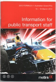
Book, Metlink, "Information for public transport staff - 2012 Formula 1 Australian Grand Prix", Feb. 2012
Book - 36 pages page full colour publication plus covers with fold out map on the rear cover titled "Information for public transport staff - 2012 Formula 1 Australian Grand Prix". Gives details of event for train, tram and bus crews, event program and transport map, including shunting details, announcements, bus replacement services, electric or automatic points, route alterations. On the back cover has contact telephone numbers and web addresses.trams, tramways, grand prix, metlink, formula 1, albert park -
 Melbourne Tram Museum
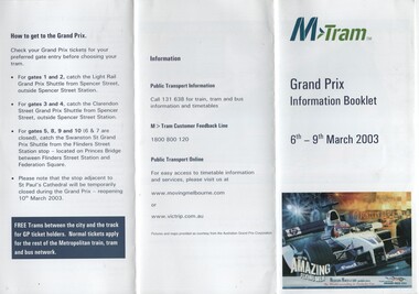
Pamphlet, M>Tram, "M>Tram - Grand Prix Information Booklet", Feb. 2003
Pamphlet - 3 fold DL from an A4 full colour sheet titled "M>Tram - Grand Prix Information Booklet" - 6-9/3/2003 printed for public distribution. Gives information on tram route changes, contact details, how to get to Albert Park, circuit map and what to take with you.trams, tramways, m>tram, grand prix, map, public transport -
 Falls Creek Historical Society
Document - Information Bulletin April 1961
Bob Hymans Collection Bob (Herman) Hymans (a former member of the Royal Netherlands Navy) was born in Bloemendaal, Holland on 30th September 1922. During World War II he fought against the Japanese in the Dutch East Indies (now Indonesia) and was imprisoned in Changi and on the Burma Railway. After gaining qualifications as a Ski Instructor, Bob arrived in Falls Creek in July 1950. Working as an Instructor and Supervisor at Bogong Lodge, Bob decided his future was in accommodation. He was successful in negotiating an indenture for land from the State Electricity Commission (SEC). It took Bob two years to build his Grand Coeur Chalet but, tragically, it was burned down in August 1961. Bob also built the first Chairlift in Australia. This was a single chairlift and the structure was built from wooden electricity poles. He was constantly full of new ideas and proposals for the village. Bob Hymans died on 7th July 2007. This Collection of documents and letters tells the story of Bob's endeavours to develop Falls Creek into the ski village it is today.This letter is significant because it documents developments made or endorsed by the Falls Creek Tourist Area Management Committee.An information bulletin published by the Management Committee. Information included is the release of a new subdivision map, establishment of a Ski Rescue Service and notification that Bob Hymans' would not be in operation for the coming season,falls creek tourist area management committee, preparations for winter season 1961 -
 Melbourne Tram Museum
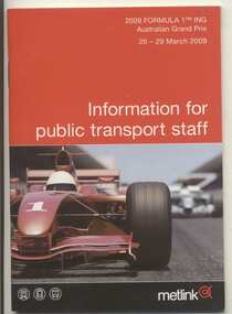
Book, Metlink, "Information for public transport staff - 2009 Formula 1 Australian Grand Prix", Feb. 2009
Forty page full colour publication plus covers with fold out map on the rear cover titled "Information for public transport staff - 2009 Formula 1 Australian Grand Prix". Gives details of event for train, tram and bus crews, event program and transport map, including shunting details, announcements, bus replacement services, electric or automatic points, route alterations. On the back cover has contact telephone numbers and web addresses. 2 copies held.trams, tramways, grand prix, metlink, formula 1, albert park -
 Melbourne Tram Museum
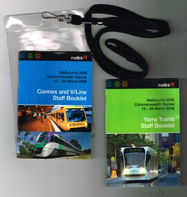
Ephemera - Timetable, Metlink, "Melbourne 2006 Commonwealth Games - 16-26 March 2006" - Yarra Trams Staff Booklet", Mar. 2006
Set of two books printed in full colour on gloss white paper, centre stapled providing information for transport staff involved in the Commonwealth Games held in Melbourne 16-26 March 2006. Both have details of event for train, tram and bus crews, event program and transport map, including shunting details, announcements, bus replacement services, electric or automatic points, route alterations and security information. On the back cover has contact telephone numbers and web addresses. Both have the Met Link logos on the front covers. Items contained with in a plastic envelope with a black neck band. .1 - "Melbourne 2006 Commonwealth Games - 16-26 March 2006" - Yarra Trams Staff Booklet" - 80 pages with a photo of 5014 on front cover. 2nd copy added 11-12-17 from Donation of Ron Scholten. .2 - "Melbourne 2006 Commonwealth Games - 16-26 March 2006" - Connex and V/Line Staff Booklet" - 96 pages with a Alstom suburban train and Bombardier Velocity set on the front covers. 2 copies held.trams, tramways, commonwealth games, connex, v/line, yarra trams, metlink -
 Melbourne Tram Museum
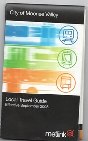
Map, Metlink, "City of Moonee Valley - Local Travel Guide - July 2008", Sep. 2008
Map, Guide book, Pamphlet, 21 fold, pocket size, titled "City of Moonee Valley - Local Travel Guide - July 2008" detailing public transport services in the City. Includes map of the tram, train networks, tickets information, tram traction , Connex SMS updates and info on Metlink including contact details. Has a detail map showing services in the city and adjacent overlap area of buses, trams and trains including route numbers. See Reg Item 2250 for City of Boroondara version.trams, tramways, city of moonee valley, map, guides, bus services, metlink, connex -
 Melbourne Tram Museum
Map - Metlink folder - Travel Smart Maps, Travelsmart - Department of Infrastructure, "Melbourne's Public transport Map", 2005 to 2006
Set of four maps issued by Metlink - 2005 to 2006 contained within a Metlank badge plastic folder. Maps published in association with Melway 1 - 5 x 8 fold map with card cover dated Jan 2005 with a price of $2. Detailed map showing rail, tram and bus routes. 2 - 6 x 4 fold map for Moonee Valley - Travelsmart - for public transport, walking and cycling - dated 2005 3 - 7 x 4 fold map for Moreland - Travelsmart - for public transport, walking and cycling - dated October 2006 - includes notes on taxis. 4 - 7 x 4 fold map for Ride to Work day - 5 Oct. 2005Yields information about Melbourne Public Transport network.Metlink plastic folder containing maps.maps, metlink, public transport, moreland, moonee valley, travelsmart -
 Melbourne Tram Museum
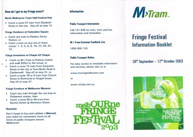
Pamphlet, M>Tram, "Fringe Festival Information Booklet", Sep. 2003
Pamphlet - DL size, three fold full colour printed on gloss paper titled "Fringe Festival Information Booklet", giving details of the festival, what's on, how do I get there, a map of the Melbourne tram network, use of Metcards. Published by M>Tram for the festival - 26/9 to 12/10/2003.trams, tramways, festival, m>tram, tickets -
 Melbourne Tram Museum
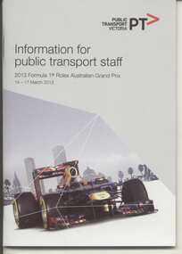
Book, Public Transport Victoria (PTV), "Information for public transport staff - 2013 Formula 1 Rolex Australian Grand Prix", Feb. 2013
Gives details of event for train, tram and bus crews, event program and transport map, including shunting details, announcements, bus replacement services, electric or automatic points, route alterations. On the back cover has contact telephone numbers and web addresses for Public Transport Victoria (PTV). Held 14 to 17 March 2013Demonstrates a staff information booklet used a Grand Prix event.Twenty Four page transport staff - 2013 Formula 1 Rolex Australian Grand Prix". 2nd copy added 13-1-2015trams, tramways, grand prix, ptv, formula 1, albert park -
 Warrnambool and District Historical Society Inc.
Map - Tourist Map Collection: Warrnambool & District Tourist Maps, Philprint, Warrnambool
This is a diverse collection of Tourist Maps for the Warrnambool & District area. [.1] From information on this guide it dates from the mid 1970's. It appears to not have been commercially printed and includes details of attractions no longer operating in Warrnambool such as Warrnambool Aquarium and the Oasis Reptile Park and Zoo. [.2] Commercially printed Warrnambool tourist map (c mid 1980's) surrounded by advertisements for local businesses. [.3] Commercial printed December 1991 tourist map of Warrnambool and District includes a competition entry form [.4] Commercially printed tourist map aimed at children [.5] Walking map of Warrnambool and District [.6] Commercially printed Warrnambool tourist map (c mid 1980's) surrounded by advertisements for local businesses. This collection of maps from the mid 1970's to early 1990's gives an insight into what was available to assist tourists find their way around Warrnambool and District. They include advertisements for business operating during this period and include lists of available accommodation, eateries, and tourist attractions.[.1] Tourist Attractions In and Around Warrnambool two foolscap pages with two sides of type written information of local and district attractions. There is a Warrnambool City map with points of interest marked and a hand drawn district map; [.2]Commercially printed grid map of Warrnambool City surrounded by advertisements from local businesses. Reverse side has a district map and a map of the Warrnambool CBD surrounded by advertising. [.3] Brochure including small grid maps of Warrnambool and district listing accommodation providers and places of interest. Stylised blue & bright green design of Norfolk pines and sea. [.4] Children's treasure hunt map to Warrnambool There are two examples, one with blue edging (Jan 1986) and one with red edging (Aug 1993) Both have a circular logo with a stylised whale and lighthouse [.5] Walking maps of Warrnambool blue printed photo of four tourists walking coastline on the front cover. [.6] Commercially printed grid map of Warrnambool with a bright yellow inset of Warrnambool CBD main shopping centre. The map is surrounded by advertising for local businesses.warrnambool, tourist maps, warrnambool businesses, warrnambool accommodation -
 Falls Creek Historical Society
Booklet - Falls Creek Information Winter 2010
Falls Creek featured several new programs and activities in 2010. Australia's ultimate skiing tour was launched with Back Country Tours guided by Steve Lee, Falls Creek's most famous local and Australian Olympian. The full length of Wombats Ramble was also lined with lights to provide night skiing and boarding on Wednesday and Saturday nights throughout the season. Pete the Big Blue Dragon was also a Falls Creek celebrity and had his own weekly stage show at the Village Bowl and often frequented the Fox Trail Terrain Park. He also had his own website full of games, stories, merchandise and a snow safety video. 2010 also saw the introduction of the Snow Rewards Loyalty Program. Members had access to cheaper Lift Passes and a range of exclusive discounts at both Falls Creek and Hotham. Corporate sponsors in 2010 included ANZ Bank, Milo, Ten TV, Snow Australia and Where IS maps.This booklet is significant because it documents seasonal activities at Falls Creek in 2010.A booklet of 56 pages promoting Falls Creek for the Winter season 2010. It includes text, images and advertising printed on glossy paper with a heavier card cover.falls creek marketing, back country tours, wombats ramble -
 Warrnambool and District Historical Society Inc.
Book - Family Bible, John Murphy Company, The Holy Bible Douay Version, 1899
This Bible and cover belonged to Ethel Ardlie, nee Ryan (1880-1967). In 1903 she married Arthur Stanley Ardlie of Warrnambool. Arthur Ardlie was the son of the prominent Warrnambool lawyer, William Ardlie and his wife Mary and the grandson of John and Mary Ardlie, pioneer settlers in Warrnambool. Ethel and Arthur Ardlie had three daughters, Olive (1905- 1912), Dorothy (1910-1993) and Agnes (1915-1993). They lived at Aroona, Princess Street, Warrnambool.These items are of great interest firstly because they are examples of the type of Bible and cover that families owned in the mid 20th century. Also they are mementoes of a prominent family in Warrnambool in the 20th century, with the Bible containing important information on this family. .1 This is a Bible with a black cover with gold lettering on the spine. The cover is stained. The pages contain the Old Testament (1086 pages), a Family Register section, the New Testament (306 pages) and some coloured maps. Amongst the pages are two pressed pansies and two loose sheets. .2 This is a brown tooled leather cover for the Bible with a brown silk lining and a brown cord attached to the top of the spine for use as a bookmark. The front cover has an embossed image of seven figures. The edges of the spine of the cover are torn. Ethel M. Ardlie (x2) Aroona, Warrnambool ardlie family, history of warrnambool -
 Bendigo Military Museum
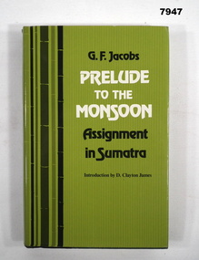
Book - AUTOBIOGRAPHY, G. F. Jacobs, "PRELUDE TO THE MONSOON ASSIGNMENT IN SUMATRA", 1982
Refer Cat No. 7944. Item in the collection of "Arthur E. Tranter" V50166 - VX52843, 2/29th Bn P.O.W.Hard cover with dust cover. Hard cover - cardboard, with black colour buckram on spine, green colour paper adhered cover. Gold colour print on spine. Dust cover - paper, with glass finish. Black and white colour print on front, spine and back. Front and back flap information. 249 pages, cut, plain, off white colour paper. Illustrated - black and white photographs and map.books, miliitary history, ww2, sumatra, autobiography -
 Warrnambool and District Historical Society Inc.
Booklet - Booklet Collection: City of Warrnambool Tourist Guides, Collett, Bain and Gaspar, Warrnambool
This is a collection of sixteen tourist guides dating from the mid 1970's to 2013. These contain listings of businesses, accommodation, eateries and events in Warrnambool and district. They also include maps of Warrnambool and surrounds, advertising and photographs of various attractions. While mainly covering Warrnambool a small number of the guides cover the South West Region. These directories have mainly been published by the Warrnambool City Council and are a selection of the types of information provided to visitors at the Tourist information centre during this time period.These tourist guides give snapshots of the City of Warrnambool for the years covered and will be useful for research.[.1] An 8 page paper booklet with black printing and a black & white photo of the pond at the Botanical Gardens on the front cover. [.2] two photocopied A4 black and white pages from the book "On the Trail" K Winser 1956 (Main Roads of Australia) [.3] A trifold colour brochure with a stylised map of the coast on the yellow and blue front cover. The inside has stylised colour drawings on Warrnambool attractions. The rear cover has coloured photographs of bush, Liebig Street and Fletcher Jones gardens [.4] A trifold black and white brochure with a black line drawing of a whale on the front cover. [.5] A trifold white card with mauve printing. The front cover has a line drawing of the former Timor Street post office and a map of businesses and landmarks in Timor Street. The reverse side contains a brief history of Warrnambool. [.6] A 98 page stapled booklet with a foreword by Vanda Savill. There are 4 pages of coloured photographs. The remainder are black and white photographs. The front cover is purple with white writing in the lower third. There is an outline of the coast and five colour photographs of district attractions. The inside middle page has a map of the Western wonderland region. The content covers towns in this area. Content relating to Warrnambool is in the last six pages. [.7] Twelve loose photocopied black and white pages. The front cover has the Warrnambool Premier Town 1988-1991 logo and a photo of a Southern Right Whale and calf. The bottom right hand corner has a Standard Warrnambool logo. [.8] 44 page booklet printed with blue ink. The staples have been removed. The glossy front cover has blue printing with a coloured photo of Flagstaff Hill Maritime Village pond. The centre pages has a fold out map of the City of Warrnambool. The rear cover has photos of The Twelve Apostles and Hopkins Falls. [.9] 4 loose photocopied pages with Warrnambool Library and Corangamite Regional Library Service Warrnambool City Library black ink stamps. The front page line drawing illustrations of Warrnambool attractions [.10] A single sheet of glossy white paper folded in half to make four pages. The front page has a Warrnambool premier town logo 1979-1982 and blue printing and a visitor survey. [.11] A conference pack of light card folded to make a pocket containing three brochures, a shipwreck coast tourist directory and a Australian Heritage Parks Association conference program dated 24 to 27 May 1992. The front cover of the pack has green writing over a stylised upward arrow. There is a City of Warrnambool logo in the top right hand corner and two film strips diagonally across the cover containing photographs of Warrnambool. The rear cover has a coloured Warrnambool Premier Town logo. [.12] A 63 page stapled booklet with coloured photographs of Warrnambool. The front cover has black writing on white background. There is a coloured photograph of Flagstaff Hill in the middle of the cover and a Warrnambool City and Visit Victoria logos on the lower edge. The middle pages has a coloured of the city of Warrnambool with an inset map of Allansford. [.13] A single large sheet of white paper folded in ten to make a brochure. The front cover has black printing. The rear cover has a purple ink stamp for the City of Warrnambool Tourist Information Centre. When folded out the reverse side has a green, grey and white map of the South West Region of Victoria. [.14] A 48 page colour booklet on glossy paper. The front cover has white writing on a blue background and includes photographs of the Twelve Apostles, the Promenade walk, Flagstaff Hill and a southern right whale's tail. The rear cover has photographs of The Twelve apostles, a passenger train from Melbourne passing the Lake Pertobe playground, and a rural scene. There is white writing and a white Warrnambool City logo on a blue background. The centre pages have a stylised green and blue map of the city of Warrnambool. [.15] A 48 page colour booklet on glossy paper. The front cover has white writing over colour photographs of two people at a lookout, Flagstaff Hill, three southern right whales and a child at the Lake Pertobe playground. The lower edge has blue upper case writing on a white background. The rear cover has a colour photograph of the Twelve Apostles. The lower white border on the rear covers has a a blue and green City of Warrnambool logo and blue writing. The centre pages have a stylised green and blue map of the city of Warrnambool. [.16] A 64 page colour booklet on glossy paper. The front cover has black writing on a black background and there is a photograph of a southern right whale's tail. The lower edge has the Warrnambool City and Visit Victoria Logos. The centre pages have maps of Warrnambool and surrounds. [.1] This week in Warrnambool Vol 2 No. 5 Thurs 1st Feb. For the time of your life [.2] Warrnambool Way [.3] Warrnambool The Holiday Host on the South West Coast with compliments City of Warrnambool and Warrnambool Chamber of Commerce [.4] MMI Insurance presents Whales Giants of the Deep Whale Watcher's Logbook Warrnambool [.5] Warrnambool History began in Timor Street [.6] Western Wonderland Tourist Association [.7] A Premier Arrow Tour of Warrnambool Victoria's Premier Town Australia's Southern Right Whale Nursery [.8] Warrnambool The Heart of Victoria's Great Southwest Visitor's Handbook [.9] What to see in Warrnambool Victoria's Premier City 1979-1982 [.10] Win a Free Holiday & $200 Cash in Victoria's Premier Town [.11] Advancing Warrnambool together! [.12] Great Ocean Road Warrnambool Official Visitor Guide [.13] Tourist guide to the South West Region Victoria All it needs is you [.14] Warrnambool visitor guide 2005 the great ocean road experience attractions accommodation entertainment dining [.15] Warrnambool Visitor Guide 2006 the great ocean road experience Attractions Accommodation Entertainment Dining [.16] Official Visitors' Guide Warrnambool Victoria Australia Discover the Great Ocean Road warrnambool, warrnambool tourist guides -
 Mission to Seafarers Victoria
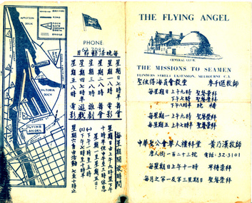
Flyer, Victorian Seamen's Mission, The Flying Angel, 1963-1966
The Mission accommodated seamen from all nationalities from the earliest days of operation. Asian seafarers are recorded visiting the Mission from the late 19th C. onwards. The first Chinese chaplain to be appointed was Rev Steven Wong who moved to Melbourne in the 1960s. Rev Wong served from 1963-1966 and according to his sons helped design these information brochures. Images of Rev'd Wong are included in the VC Database. The pamphlet gives days and times of activities such as dances and films and chapel services. The Chinese writing was made by Reverend Stephen WongA rare surviving period example of a non-english speaking flyer on information about the Mission to Seafarers Victoria Commercially printed paper single fold flyer providing directions and information to the Central Club, Missions to Seamen at Flinders St extension, in Mandarin. Contains a drawing of the central mission and a map of Docklands.In English: CENTRAL CLUB/THE MISSIONS TO SEAMEN, FLINDERS STREET EXTENSION, MELBOURNE C.3 In Mandarin: Translation (from Google translate): date and time of services / date and time for dances, movie sessions, teareverend stephen wong, mandarin, chinese, asian, reverend perry mitchinson -
 Ringwood and District Historical Society
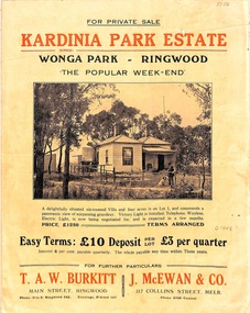
Flyer, Land Sale Brochure, Kardinia Park Estate, North Ringwood, Vic. - circa 1948
Folded buff-coloured land sale advertisement for Kardinia Park Estate in Warranwood area of North Ringwood, including terms of sale, area map, layout plan of the estate, and summary of local facilities and services. Front page features photograph of a man and dog in front of a house captioned as Lot 1 on four acres shown on the estate layout as cnr of Brysons Road and Range View Parade (later Omeo Parade). Second page includes bushland swimming pool photograph and promotional information for prospective buyers.Subdivision includes Kardinia Crescent, Wonga Road, Brysons Road, Range View Parade (later Omeo Parade), Motor Coach Road (later Wonga Park Road, then Warranwood Road). (Agent/s) T.A.W. Burkitt, Main Street, Ringwood, Phone (9 to 6) Ringwood 242, Evenings, Ringwood 157, and J. McEwan & Co, 317 Collins Street, Melbourne, Phone 6750 Central. -
 Bendigo Military Museum
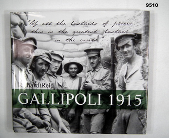
Book - WW1 PICTORIAL, Richard Reid, "GALLIPOLI 1915", 2002
Item in the Cooper Collection.Hard Cover Book with Dust Cover. Hard cover - cardboard with adhered paper cover, white and black print on front, spine and back. Illustrated with black and white photographs. Front - group of six soldiers standing, with sandbags in the background. Back - soldier in silhouette pouring a cup of tea against background of sea and a ship. Dust cover - paper, print and photographs as above. front and back flaps - white colour print on green background. End papers - grey and black photographs of battle scenes. 154 pages - cut, plain, white colour semi gloss paper. Pictorial book with colour and black and white photographs, maps, posters, postcards and handwritten information.publications, books, ww1, gallipoli, cooper collection -
 Warrnambool and District Historical Society Inc.
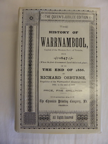
Book, The History of Warrnambool by Richard Osburne, 1980
Richard Osburne (1825-1895) came to Warrnambool in 1847, a pioneer resident in the new settlement. In 1851, with John Wilkinson, he founded Warrnambool’s first newspaper, the Warrnambool Examiner, and issued it weekly for some months until he left the town for the goldfields. Returning in 1853 he resumed publication of the Examiner and continued it, intermittently in its last few years, until 1880. He was acknowledged in his day as the Father of the Warrnambool Press and was a dominant figure in Warrnambool’s early history. He was associated with the establishment of the Aboriginal Reserves, Fire Brigade, Mechanics’ Institute, Warrnambool Council, National School, Presbyterian Church, Public Wants Committee, Villiers Building Society, Fish Protection Society, Dramatic Club, Cricket Club, Otway Gold Exploration Syndicate and other institutions. In 1882 he went to live in Melbourne, returning to publish his ‘History of Warrnambool’ in 1887, a Queen’s Jubilee publication. Richard Osburne’s book is a seminal work of the 19th century history of Warrnambool and its importance cannot be over-emphasized. The original copies of this book are now hard to get and are very valuable. This facsimile is kept because the facsimiles are also now becoming rare and they are good examples of the way a facsimile is reproduced and the reason for the existence of this particular reprint– the importance and usefulness of Osburne’s history and the need to make it accessible to researchers today.This is a facsimile edition (1980) of Richard Osburne's book on the history of Warrnambool from 1847 to 1886. It is a hard cover buff-coloured book with gold lettering on the spine. The dust cover is cream-coloured paper with black writing. Inside the cover is a map of southwest Victoria (1880). There are five fold-up inserts (sketches, diagrams etc), a number of business advertisements, sepia photographs and sketches and an index. The dust cover includes information on the author. There are 25 chapters, a foreword by the Prime Minister of Australia, Malcolm Fraser and a Preface The proceeds of the book reprint went to Flagstaff Hill Maritime Village.This is a facsimile edition (1980) of Richard Osburne’s book on the history of Warrnambool from 1847 to 1886. It is a hard cover buff-coloured book with gold lettering on the spine. The dust cover is cream–coloured paper with black writing. Inside the cover is a map of southwest Victoria (1880). There are five fold-up inserts (sketches, diagrams etc), a number of business advertisements, sepia photographs and sketches and an index. The dust cover includes information on the author. There are 25 chapters, a foreword by the Prime Minister of Australia, Malcolm Fraser and a Preface The proceeds of the book reprint went to Flagstaff Hill Maritime Village.richard osburne, the history of warrnambool, warrnambool examiner -
 Warrnambool and District Historical Society Inc.
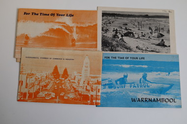
Booklet - Warrnambool Tourist Guides (5), Warrnambool Chamber of Commerce and Industry, Warrnambool - For the Time of Your Life, 1970-1975
Warrnambool Tourist Guides 1970-1975.1,.2,.3 - These are booklets of 36 pages with an orange cover with an illustration of two people on surf boards on the front cover and an image of a main street on the back cover. The cover has blue printing. The pages contain a map, advertisements, black and white photographs and printed text. One booklet is stapled and two have the staples removed. .4,.5 -These are booklets of 40 pages with a front cover with a photograph in blue tones of a surf patrol boat and two lifesavers and a back cover with a black and white photograph (beach scene). The pages contain a map, advertisements, black and white photographs and printed text. One booklet is stapled and one has the staples removed. non-fictionWarrnambool Tourist Guides 1970-1975warrnambool tourism, tourism in warrnambool in the 1970s -
 Warrnambool and District Historical Society Inc.
Pamphlet (Collection) - Warrnambool Tourist Maps, Warrnambool City Council, 1975 to 2002
Warrnambool Tourist Maps collected over the years by Warrnambool Historical Society membersPreservation of local maps for historical purposesEnclosed in A4 size plastic envelopes in an A4 size archival box and numbered and catalogued according to the date of acquisition.This collection has 16 pamphlets containing maps of Warrnambool and district and some accompanying printed materialwarrnambool tourism, city of warrnambool, shipwreck coast tourismwarrnambool tourism, city of warrnambool, shipwreck coast tourism -
 Wodonga & District Historical Society Inc
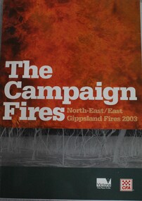
Book - The Campaign Fires - North-East/East Gippsland Fires 2003, Lyndel Hunter, 2003
... , maps and detailed information related to the 2003 bushfires... This publication of 119 pages features text, colour images, maps ...A description of efforts to fight the bushfires in Gippsland in 2003, including maps and illustrations This volume was published as a tribute to the work of staff and volunteers who put themselves at risk to protect local communities. It shows the impact on those communities in Victoria and the support they gave to those involved in fighting largest bushfires in Victoria for 60 years. The Alpine bushfires started on 8 January 2003, a day of Total Fire Ban. Lightning ignited 87 fires in the North-East and East Gippsland regions. Eight of these fires were unable to be contained; they joined together to form the largest fire in Victoria since the Black Friday fires in 1939. The majority of the area burnt in Victoria was public land, 1.19 million hectares of parks and forests, including 60 per cent of the Alpine National Park and 81 per cent of the Mt Buffalo National Park. Firefighting efforts were made difficult in hard to access, remote forest terrain. Approximately 90,000 hectares of private land was burnt.This publication of 119 pages features text, colour images, maps and detailed information related to the 2003 bushfires in Victoria.non-fictionA description of efforts to fight the bushfires in Gippsland in 2003, including maps and illustrations This volume was published as a tribute to the work of staff and volunteers who put themselves at risk to protect local communities. It shows the impact on those communities in Victoria and the support they gave to those involved in fighting largest bushfires in Victoria for 60 years. The Alpine bushfires started on 8 January 2003, a day of Total Fire Ban. Lightning ignited 87 fires in the North-East and East Gippsland regions. Eight of these fires were unable to be contained; they joined together to form the largest fire in Victoria since the Black Friday fires in 1939. The majority of the area burnt in Victoria was public land, 1.19 million hectares of parks and forests, including 60 per cent of the Alpine National Park and 81 per cent of the Mt Buffalo National Park. Firefighting efforts were made difficult in hard to access, remote forest terrain. Approximately 90,000 hectares of private land was burnt.forest fires -- victoria, bushfires, fires prevention and control -
 Bendigo Historical Society Inc.
Book - STRAUCH COLLECTION: RESEARCHING YOUR GERMAN ANCESTORS
BHS CollectionManilla folder containing information on researching your German ancestors with illustrations and a map.genealogy, family, german, genealogy-german -
 Ballarat Tramway Museum
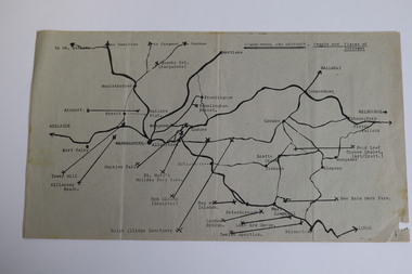
Document - Letter/s, Dave Macartney, Nov. 1970
Yields information in the form of a letter from an active tram enthusiast at the time recommending that part of the Ballarat system be retained for heritage tramway operation by the TMSV.Two typed A4 size sheets, photocopied, undated, early 1971 written by Dave Macartney of Albert Park to a number of people recommending that the TMSV establish a tramway museum in Ballarat around the shores of Lake Wendouree. Includes a map showing a possible track layout. Gives supporting cases, issues, problems, notes tourism potential, street running and other matters. Has been hand address to "Graeme". Dave Macartney advised 6/10/2007 that written November 1970, 50 copies made."Graeme" in blue ink.trams, tramways, ballarat, preservation, tmsv -
 Bendigo Historical Society Inc.
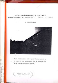
Book - STRAUCH COLLECTION: GREIFFENHAGENS CELLAR (HERCYNIA VINEYARD)
"Hercynia" was the largest vineyyard in the Bendigo District. It was started by Carl Wilhelm Greiffenhagen (William) and his cousins, twins, Carl and August Heine. The first vine cuttings were planted in 1860. The partners owned 300 acres at Axe Creek and in 1862 had 24 acres under vines and an orchard of 4 acres. By 1884 they had expanded to 30 acres of vines. They produced many award winning wines. August Heine ( 1832 - 1898) was born in Germany and came to Australia in 1854 with his twin brother Carl and their cousin William Greiffenhagen. Initially the three took up mining successfully but then the partnership bought 300 acres at Axe Creek and planted a vineyard. They also grew fruit and crops to feed the working horses. In 1870 August sold his interest in the vineyard and set up his own smaller vineyard at Sheepwash Gully. He had several business interests before he took up the caretaker position at the newly dug Weeroona lake, a position he held until his death. Carl Heine sold his interest in the vineyard in 1873 and returned to Germany. WIlliam Grieffenhagen (1834-1916) continued his very successful vineyard until the region was hit with a highly infectious vine disease in 1893. Although his own vines escaped infection, he was within the 2 mile quarantine area and was forced to dig out all his vines. He never replanted but depended on his orchard instead. He was a founding member of the Bendigo Agricultural Society and a local Shire councillor for several years. In 1870 he married Margaret Boyd.Binder containing information relating to Greiffenhagen's cellar (Hercynia Vineyard) 1860 - 1991 including black and white photographs & maps, compiled by John Houlahan as a third year thesis whichnis pat of the assessment for a Bachelor of Arts (Social Science) degree. Donated to the German Society 15/2/96 by the Grandfather of author Jack Houlahan.John Houlahanbook, bendigo, wineries, bendigo-history-axe creek- wineries- german -
 Melbourne Tram Museum
Pamphlet, Trammies at South Melbourne Depot, "Conductor to Public Bulletin Number One", early 1990's
Pamphlet - three fold A5 size, printed on green paper, titled "Conductor to Public Bulletin Number One" with a sub-title "produced to aid Commuters hungry for information, by Trammies from the South Melbourne Depot" Gives a part history of the W class Melbourne and why they fit Melbourne, notes on Melbourne's, gives a map of other Australian tramway systems, comparison with the San Francisco and Los Angeles. Has a note on the side of the rear page "Printed on Recycled scratch tickets". Printed early 1990's?trams, tramways, south melbourne depot, conductors, melbourne, public transport, w class -
 Melbourne Tram Museum
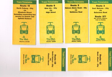
Ephemera - Timetable, The Met, Set of 12 Tram Timetables, produced by The Met, 1987 - 1989
Set of 12 Tram Timetables, produced by The Met for various routes, yellow cover with a green top band, multi fold horizontal sheet, giving a route map, description, notes, time points, information contact details and types of tickets (Neighbourhood and Travelcards) and where they could be purchased. .1 - Route 3 - East Malvern - City via Balaclava Road - replaced by bus 377 on Sundays - dated 14/9/1987 .2 - Route 5 - Malvern Burke Road - City via Wattletree Road - 19/6/1988 .3 - Route 6 - Glen Iris - City via High St - 19/6/1988 .4 - Route 19 - North Coburg - City via Elizabeth St including connecting bus service to Gowrie and Upfield stations - 14/11/1988 .5 - Route 42 - Mont Albert - City - 15/8/1988 .6 - Route 48 - North Balwyn - City via Flinders St - 31/10/1988 .7 - Route 55 - West Coburg - Domain Interchange via William St - 11/2/1987 .8 - Route 57 - West Maribyrnong - City via North Melbourne - Route 357 bus replaces tram on Sunday - 27/8/1989 .9 - Route 59 - Airport West - City via Essendon - 27/8/1989 .10 - Route 64 - East Brighton - City via Hawthorn Road - 14/9/1987 .11- Route 70 - Wattle Park (Elgar Road) Princes Bridge via Swan St - 31/10/1988 .12 - Route 86 - Bundoora - City via West Preston - 15/8/1988 Full Image of .4 added 9/4/17 following a query about route 19 timetables - see image i5.trams, tramways, timetables, tickets, tram services, route 3, route 5, route 6, route 19, route 42, route 48, route 55, route 57, route 59, route 64, route 70, route 86 -
 Melbourne Tram Museum
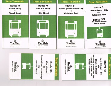
Ephemera - Timetable, The Met, Set of 18 Tram Timetables, produced by The Met, 1986 - 1988
Set of 18 Tram Timetables, produced by The Met for various routes, white cover with two green, multi fold horizontal sheet, giving a route map, description, notes, time points, information contact details and types of tickets (Neighbourhood and Travelcards) and where they could be purchased. .1 - Route 3 - East Malvern - City via Balaclava Road - replaced by bus 377 on Sundays - dated 14/9/1987 .2 - Route 5 - Malvern Burke Road - City via Wattletree Road - 19/6/1988 .3 - Route 6 - Glen Iris - City via High St - 19/6/1988 .4 - Route 8 - Toorak - City via Toorak Road - 19/6/1988 .5 - Route 19 - North Coburg - City via Elizabeth St including connecting bus service to Gowrie and Upfield stations - 11/3/1987 .6 - Route 55 - West Coburg - Domain Interchange via William St - 11/2/1987 .7 - Route 57 - West Maribyrnong - City via North Melbourne - Route 357 bus replaces tram on Sunday - 1/12/1986 .8 - Route 59 - Airport West - City via Essendon -1/12/1986 .9 - Route 64 - East Brighton - City via Hawthorn Road - 14/9/1987 .10 - Route 67 - Carnegie - City via Glenhuntly Road - 14/9/1987 .11 - Route 69 - Kew (Cotham Road) - St Kilda Beach via Glenferrie Road - 19/6/1988 .12- Route 72 - Camberwell - City via Malvern Road - 19/6/1988 .13 - Route 75 - East Burwood - City via Flinders St - 15/2/1988 .14 - Route 78, Route 79, North Richmond - Prahran via Chapel St and North Richmond - St Kilda Beach via Chapel St - 13/7/1987 .15 - Route 82 - Footscray Moonee Ponds via Highpoint City and Route 223 bus replacement for Saturday afternoon and all day Sunday. 3/8/1987 .16 - Route 88 - Bundoora - City via Preston .17 - Route 96 - East Brunswick - St Kilda Beach via Bourke St City - 22/11/1987 .18 - Route 111 - Royal Exhibition Buildings - Port Melbourne via Bourke St City - 20/12/1987. (2nd copy added 1/4/20201( .19 - Route 600 - St Kilda - Middle Brighton via Elwood - 1/12/1986 Full Image of .5 added 9/4/17 following a query about route 19 timetables - see image i6.trams, tramways, timetables, tickets, tram services, route 3, route 5, route 6, route 19, route 55, route 57, route 59, route 64, route 8, route 67, route 69, route 72, route 75, route 78, route 78, route 79, route 82, route 88, route 86, route 111, route 600 -
 Melbourne Tram Museum
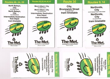
Ephemera - Timetable, The Met, Set of 7 Tram Timetables - The Met, 1986
Set of 7 Tram Timetables, Printed fold out timetable for various tram routes, published by The Met. Provides a map, description of route, time points, timetable, ticketing information (Travel cards and Neighbourhood tickets). .1 - Routes 9 and 14 - Northcote City both via Collins St and Latrobe St. - 13/4/1986 .2 - Route 30 - City - Brunswick St via Latrobe St - 24/3/1986. .3 - Routes 42, 23, 33, 45 and 47 - Mont Albert both via Collins St and Latrobe St. and Kew Depot - 12/2/1986 .4 - Routes 48, 24 and 29 North Balwyn both via Collins St and Latrobe St. and Kew Depot - 24/3/1986 .5 - Routes 70 and 76 - Wattle Park and Camberwell Depot - 24/3/1986. .6 - Route 76, 76 and 28 - East Burwood - City, Camberwell Depot and Richmond - 24/3/1986 .7 - Route 96, 97 and 95 - East Brunswick - 24/3/1986trams, tramways, timetables, tickets, tram services, route 9, route 14, latrobe st, la trobe st, kew depot, route 30, route 42, route 23, route 44, route 45, route 47, route 48, route 24, route 29, route 70, route 76, route 75, route 28, route 96, route 97, route 95, camberwell depot -
 Melbourne Tram Museum
Ephemera - Timetable, Melbourne & Metropolitan Tramways Board (MMTB), Set of 14 MMTB Bus timetables, Jul. 1969
All July 1969 - no route numbers shown. .1 - Box Hill - Heidelberg - Templestowe .2 - East Kew - Box Hill - Doncaster .3 - Deer Park - Sunshine Park - Sunshine - Footscray - City .4 - Fishermen's Bend - City .5 - Williamstown Rd - Footscray Railway Stn - Ballarat Rd .6 - Garden City - City .7 - La Trobe University - Northland - West Heidelberg - City .8 - Box Hill - North Blackburn .9 - Bulleen - North Kew - City .10 - Clifton Hill - Elsternwick .11 - Box Hill - East Doncaster - Mitcham - Ringwood .12 - Deer Park - Sunshine Park - Sunshine - Footscray - City - Saturdays and Sundays - printed on pink paper. 13 - Warrandyte - Donvale Post Office - City 14 - Warrandyte - Park Orchards, Ringwood.Yields information about MMTB Bus services July 1969Set of 14 MMTB Bus timetables, folded sheets, providing timetables for specific routes, day of week giving information on tram times at specific time points, route map, sections and fares and organisation address - 616 Little Collins St. Melbourne.trams, tramways, timetables, tickets, bus services, fares, mmtb -
 Melbourne Tram Museum
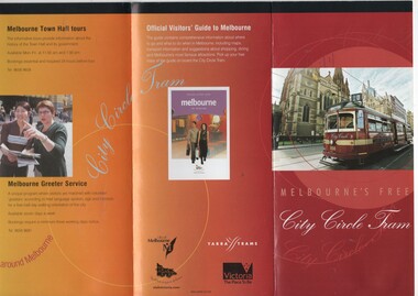
Pamphlet, Department of Infrastructure (DOI), "Melbourne's Free City Circle Tram", 2005
Pamphlet - folded to DL size, 8 fold, titled "Melbourne's Free City Circle Tram" and on rear "Official Visitors Guide to Melbourne". Details the City Circle tram, c2005 - has route via Harbour Esplanade - map shows various points, the Golden Mile heritage walk. Has the Victoria government, City of Melbourne and Yarra Trams logos. Provides information on the points of interest and the Visitor Centre. Gives a short history of Melbourne's tram and has a photo of V214 See Reg Items 1199, 866 and 2993 for other versions.trams, tramways, city circle, yarra trams, docklands, tram 856, tram 888, tram 214, tram 3004