Showing 1315 items matching "looking west"
-
 City of Kingston
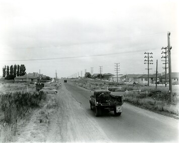
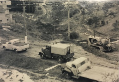
Photograph - Black and white, c. 1957
... Black and white photograph looking west along South Road... photograph looking west along South Road. There is a truck ...This image shows the urbanisation of a formerly rural area of Moorabbin.Black and white photograph looking west along South Road. There is a truck in the foreground, travelling along the sealed South Road. A car is waiting to exit from Rowan Road. People are walking along the left hand side of the road, and a young person a bike is riding along the right side. They are all going in the same direction as the traffic. The left hand side of the image shows paddocks in the foreground, which houses further back. The right hand side of the image shows suburban houses with electricity poles running the length of the road. Handwritten in blue ink on reverse: 57-523A Handwritten in red ink on reverse: 85% Handwritten in black ink or grey lead: Ch. 6moorabbin, cars, roads, housing -
 Ballarat Tramway Museum
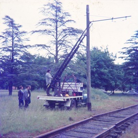
Photograph - Digital image Set of 6, John Theodore, c1973
... - access track looking west with the poles installed and a rather... looking west with the poles installed and a rather muddy area ...Yields information about the BTPS placing poles for the overhead along the access track and working on them.Set of 6 digital images scanned from 35mm slides of the installation of poles and bracket arms on the access track mid 1973. .1 - Warren Doubleday about to climb the ladder to work on a pole on the access track - note the access track which had yet to be jointed. .2 - positioning the truck etc. .3 - ditto with Geoff Cargeeg .4 - drilling holes for the poles on the access track .5 - access track looking west with the poles installed and a rather muddy area - winter 1973? .6 - drilling holes for the polestrams, tramways, btps, trackwork, depot, tramcars, overhead -
 Melbourne Tram Museum
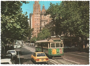
Postcard, Biscay Greetings, Collins St east of Russell St, mid 1970's
... , of an photo looking west along Collins St east of Russell St with SW5... postcard divided back - Biscay Greetings, of an photo looking west ...Colour postcard divided back - Biscay Greetings, of an photo looking west along Collins St east of Russell St with SW5 730 on a route 42 westbound. Has the Town Hall and National Mutual building in the background. Back has space for name and address, stamp and a message and details of the postcard. Produced by Biscay Greetings, possibly mid 1970's. Card No. BG119 has serrated edges. 2637.1 - same photograph, different publisher - "scanscene international" photo by R Bell. - From the Keith Kings Collection.trams, tramways, postcards, collins st, w5 class, tram 730 -
 Melbourne Tram Museum
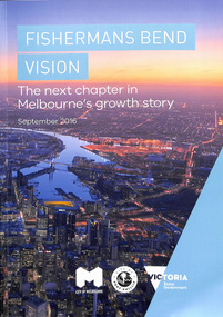
Document - Report, City of Melbourne, "Fisherman's Bend Vision - the next chapter in Melbourne's growth story September 2016", Sep. 2016
... September 2016", with a photo of Docklands, looking west. Published... September 2016", with a photo of Docklands, looking west. Published ...Report - 44 pages, A4 card cover perfect bound titled "Fisherman's Bend Vision - the next chapter in Melbourne's growth story September 2016", with a photo of Docklands, looking west. Published jointly by the City of Melbourne, City of Port Phillip and the State Government following on from Draft document of 2013. Has a table of contents. Looks at the Strategic Directions for the development of the area, Has a sketch of a tram in Plummer St, Wirraway. Refers to a website www.fishermansbend.vic.gov.au on the rear cover - active as at 18/5/2020.trams, tramways, city of melbourne, city of port phillip, fishermen's bend, new tramway, public transport, development, planning -
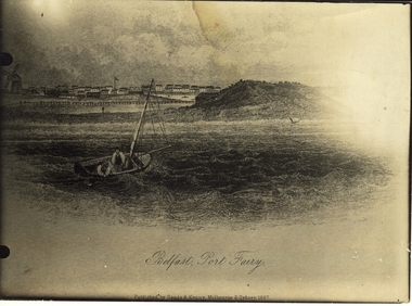 Port Fairy Historical Society Museum and Archives
Work on paper - Lithograph, S.T.Gill, Belfast, Port Fairy, 1857
... (artistic view) town looking north west from the sea showing town... looking north west from the sea showing town and windmill ...Seascape from original drawing ascribed to S.T. Gill - "Belfast, Port Fairy" published 1857Photograph of etching of seascape drawing of Port Fairy (artistic view) town looking north west from the sea showing town and windmill on the left, a man in a dingy, island in the middle and a sailing ship and Battery Hill on the rightBelfast, Port Fairy - Published by Sands and Kenny Melbourne and Sydney 1857beach, ocean, dingy, windmill, town, sea, ship -
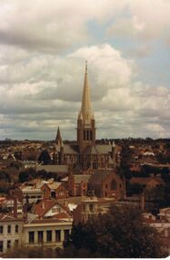 Bendigo Historical Society Inc.
Photograph - PHOTO SHOWING VIEW WEST TOWARD SACRED HEART CATHEDRAL, WESLEY UNITING CHURCH IN FOREGROUND
... Colour photo looking to the west showing the Sacred Heart... Colour photo looking to the west showing the Sacred Heart ...Colour photo looking to the west showing the Sacred Heart Cathedral, Wesley Uniting Church, and the T&G tower in the near foreground.bendigo, buildings, heritage buildings, sacred heart cathedral, wesley uniting church, and t&g insurance building tower in foreground -
 Kilmore Historical Society
Photograph, Looking South on Sydney Street from Union Street, 1860
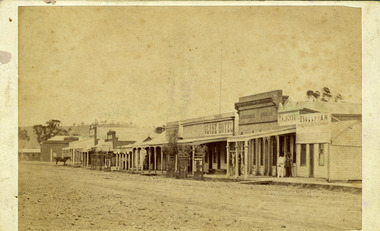
... -33 Copy LaTr. 1860 Trainor's Store etc. looking south.... looking south-west from Union St. 25cm x 20cm black and white ...25cm x 20cm black and white photograph of South-West Sydney Street. The buildings that can be seen include Kilmore Timber Yard, Riche Fitzgerald & Co Builders Ironmoncery, Red Lion Hotel. Pictured are people standing under the awning of the Ironmongers. Picture was taken in 1860. This picture is a copy from LaTrobe.Written on the back: Kilmore Historical Society #4.#5.10/86-33 Copy LaTr. 1860 Trainor's Store etc. looking south-west from Union St.shopfronts, storefronts, retail stores, 19th century -
 Ballarat Tramway Museum
Photograph - Black & White Photograph/s, Dave Macartney, c1984 or earlier
... . Taken from the Botanic Gardens looking north west. Tram has... clock. Taken from the Botanic Gardens looking north west. Tram ...Black and white photograph of Ballarat No. 27, pre 1985, running in Wendouree Parade, about opposite the Floral clock. Taken from the Botanic Gardens looking north west. Tram has blinds drawn, Twin Lakes sign.On rear has a biro and felt colour sketch of a wooden box.trams, tramways, ballarat, btps, wendouree parade , tram 27 -
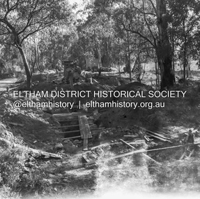
 Eltham District Historical Society Inc
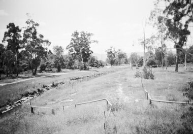
Negative - Photograph, J.A. McDonald, Eltham-Yarra Glen Road, Lower Plenty, c. July 1962
... View looking west across the Eltham-Yarra Glen Road... melbourne View looking west across the Eltham-Yarra Glen Road ...View looking west across the Eltham-Yarra Glen Road approaching the Lower Plenty Bridge near turn-off for the Golf Club Hotel. Present-day Lower Plenty Road follows a revised alignment across a new bridge. The former bridge is now part of the Plenty River Trail and Edward Willis Court now follows this section of the original Eltham-Yarra Glen Road.. The Golf Club Hotel is gone and a new Lower Plenty Hotel was built slightly further up the hill.Record of various Shire of Eltham infrastructure works undertaken during the period of 1952-1962 involving bridge and road reconstruction projects, sometimes with Eltham Shire Council Project Reference numbers quoted. It was during this period that a number of significant improvements were made to roads and new bridges constructed within the shire that remain in place as of present day (2022). In many situations, the photos provide a tangible visible record of infrastructure that existed throughout the early days of the Shire. The album was put together by or under the direction of the Shire Engineer, J.A. McDonald.1962-07, shire of eltham, old eltham road, edward willis court, eltham-yarra glen road, golf club hotel, infrastructure, lower plenty, road construction -
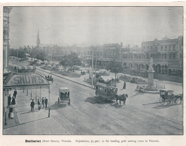 Ballarat Tramway Museum
Photograph - Illustration, "Ballarat (Sturt Street) Victoria, c1900
... St Ballarat" looking west from Grenville St with a horse tram... - illustration - Sturt St Ballarat" looking west from Grenville St ...Set of two views from an illustrated publication on Ballarat. 1 - Illustration - "Ballarat (Sturt Street) Victoria " of a horse tram eastbound on the south side of Sturt St. Has several horse-drawn vehicles in the image, the gardens in the central median strip, and Snow's store verandah. 2 - illustration - Sturt St Ballarat" looking west from Grenville St with a horse tram traveling westbound on the north side of Sturt St. Has the buildings on both sides of the street in the view along with Suttons Music store.Yields information about Sturt St from the Town Hall or Grenville St.Illustration cut from a magazine or publication - set of two - back to backballarat, illustrations, sturt st, horse trams, snows -
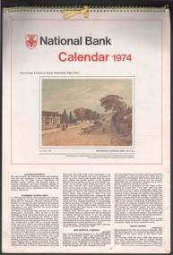 Bendigo Historical Society Inc.
Document - NATIONAL BANK CALENDAR 1974
... in series. 1. Richmond looking West. 2. New Norfolk [Tasmania] 3... Australia. Part two in series. 1. Richmond looking West. 2. New ...National Bank calendar 1974 featuring thirteen coloured views of provincial towns in early Australia. Part two in series. 1. Richmond looking West. 2. New Norfolk [Tasmania] 3. Mount Barker [SA] 4. West Maitland [NSW] 5. Gympie in 1887 [Qld] 6. Sandhurst [Vic] 7. Kiama [NSW] 8. View of Fremantle [WA], 1832. 9. Goulburn [NSW] 10. Yorkton, Port Dalrymple, Van Diemen's Land 1808. 11. Daylesford [Victoria] 12. Stanthorpe, 1888 [QLD]australia, history, colonies, establishing -
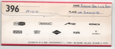 Melbourne Tram Museum
Negative, Bruce Herbert, "Burwood Tram Line Extns - near Blackburn Road", 29/12/1977 12:00:00 AM
... - showing end of slab. .2 - ditto - looking west? - shows cross... - showing end of slab. .2 - ditto - looking west? - shows cross ...Negative folder - made by SAGA Japan, containing 6 no. 120 film negatives 60mm x 90mm of the works on the extension to East Burwood, Burwood Highway, near Blackburn Road, 29-12-1977. Folder stamped 396 .1 - Burwood highway - out of focus - showing end of slab. .2 - ditto - looking west? - shows cross section of slab. .3 - Blackburn road with poles positioned - with BP service station in background. .4 - ditto .5 - sign showing tramway works in progress .6 - from the kerbside showing the track.trams, tramways, burwood highway, tramway construction, construction, east burwood -
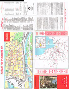 Melbourne Tram Museum
Map, Victour, "Melbourne Holiday City", c1975
... , Spencer St) in Collins St looking west with the Westgate bridge...) in Collins St looking west with the Westgate bridge in the far ...Map - 12 fold special size - full colour titled "Melbourne Holiday City", published by Melbourne Tourism, c1975 prior to the construction of East Burwood tram line, providing a list of amusements, tourist locations, places of interest, map provided by Victour, The Victorian Government Tourist Bureau, a panoramic view of Melbourne and a large map of Melbourne and suburbs showing rail, bus and tram lines and key to suburbs. Cover photo with 882 (Route 11, Spencer St) in Collins St looking west with the Westgate bridge in the far background.trams, tramways, map, public transport, city of melbourne, buses, railways, tramways, victour, tram 882 -
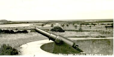 Port Fairy Historical Society Museum and Archives
Photograph, A.C. Aberline
... Battery Hill- Looking toward South West Passage. Photograph... Street Port Fairy great-ocean-road Battery Hill- Looking toward ...Battery Hill- Looking toward South West Passage. Photograph used as a post cardBlack and white Photograph of cannon on Battery Hill in the fort overlooking the South West passageSouth West Passage Port Fairy A.C.A.defence, battery hill, port fairy, cannon, fort, flagstaff hill, south west passage -
 Kew Historical Society Inc
Photograph, C Stuart Tompkins ARPS, Construction of Stawell and Yarra Streets, 1956
... Small black and white photograph looking north-west down... photograph looking north-west down Yarra Street, Kew from upper ...Yarra Street in the Studley Park section of Kew was subdivided in the 1940s and 1950sSmall black and white photograph looking north-west down Yarra Street, Kew from upper Stawell Street during street construction in 1956. Homes at 32 Stawell Street and 5 Yarra Street are partially visible on left.yarra street (kew) -
 Ringwood and District Historical Society
Photograph, Series of 4 photos from Wantirna Rd Bridge over Dandenong Creek and Gold Course. Ringwood January 1979
... : "looking west over gold club."...: "looking west over gold club." 4 Black and White photographs ...4 Black and White photographs. Written on back of photographs - all prefixed "Jan '79. :Standing on top of concrete pole at end of handrail - Wantirna Rd. bridge over Dandenong Creek -" 2674-1 / SS0357a: "looking east along creek." 2674-2 / SS0357b: "looking north-east." 2674-3 / SS0357c: "looking north." (along Wantirna Road) 2674-4 / SS0357d: "looking west over gold club." -
 City of Ballarat Libraries
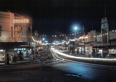
35mm Slide, Bridge Street Ballarat circa late 1950s
... A night exposure of Bridge Street looking west. The tram... Ballarat East goldfields A night exposure of Bridge Street looking ...A night exposure of Bridge Street looking west. The tram tracks are clear, one set going straight ahead up Victoria St hill, the other set turning along Main Road. Stone's at Stones Corner was a select ladies dress shop for many years. Mrs Bon Strange and her husband Bert were well known Ballarat residents. When Mrs Strange died some years ago, her extensive slide collection was sorted through and those relevant to Ballarat were gifted to the Ballarat Library. bridge street -
 Melbourne Tram Museum
Postcard - Collins Street - Biscay A1 239, Biscay Greetings, late 1980's
... Postcard looking west along Collins Street. just... Postcard looking west along Collins Street. just to the east ...Postcard looking west along Collins Street. just to the east of Swanston Street. At the time of the photograph all trams have been converted to The Met colour scheme. Swanston Street was converted into Swanston walk during 1992, so photo is late 1980's or early 1990's. There are seven trams in the view: A1 239 (City Route 42), SW5 749 in Swanston Street, A1 232 (Mont Albert Route 42), two advertising cars. Collins Street is busy. Note the Hook Turn signs supported off the overhead wires.Yields information about Collins Street late 1980's or early 1990s prior to the construction of Swanston WalkPostcard - red boarders, Collins Street - Biscay Greetings, BG 275collins street, swanston street, a1 class tram, sw5 class trams, tram 239, tram 232, tram 749, trams, tramways -
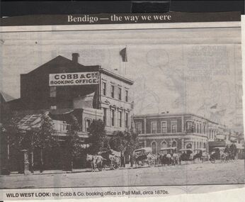 Bendigo Historical Society Inc.
Newspaper - JENNY FOLEY COLLECTION: WILD WEST LOOK
... JENNY FOLEY COLLECTION: WILD WEST LOOK...Bendigo Advertiser "The way we were" from 1999. Wild west... "The way we were" from 1999. Wild west look: the Cobb &co. booking ...Bendigo Advertiser "The way we were" from 1999. Wild west look: the Cobb &co. booking office in Pall Mall, circa 1870.newspaper, bendigo advertiser, the way we were -
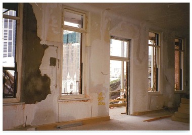 Queen Victoria Women's Centre
Photograph, c.1995/1996
... north west looking towards the veranda, no glass in windows.... Level four in the Victoria room facing north west looking ...Colour photograph. Level four in the Victoria room facing north west looking towards the veranda, no glass in windows. Taken during the restoration inspection.building construction, historic buildings -
 Melbourne Tram Museum
Photograph - Set of 2 Block Mounted Photographs, Surrey Hill Neighbourhood Centre, c1920
... in the top right hand corner of Whitehorse Road looking west near... of Whitehorse Road looking west near Yerrin St, c1920. Shows the single ...Photograph - mounted onto a heavy card, numbered 65-576 in the top right hand corner of Whitehorse Road looking west near Yerrin St, c1920. Shows the single line that was duplicated in 1923. Notes that the image is courtesy of the TMSV. See image i2 for the actual photograph. 4673.1 - loose print of the photograph with the words on the rear: "Melbourne / Whitehorse Road, Balwyn / Single Truck tram on original single track line. Probably about 1920 or so (Opened 30/9/16 and duplicated 14/2/23 from Burke Rd to Talbot Ave)On rear in ink "Reproduced C No. 1450, ?? Original photo now have Negative" and the "Surrey Hill Neighbourhood Centre" stamp. On the front under the number "Original Neg No. 2106"trams, tramways, whitehorse road, balwyn -
 Melbourne Tram Museum
Photograph - set of 3 Black and White photographs, Tramway Museum Society of Victoria (TMSV), c1975
... made by the TMSV Sales of: .1 - Bourke St, looking east... the Myer building. c1920? .2 - Bourke St looking west from ...Series of three Black & White Photographs of a postcards made by the TMSV Sales of: .1 - Bourke St, looking east with the GPO in Elizabeth St in the view, along with many vehicular traffic - has the Myer building. c1920? .2 - Bourke St looking west from Swanston St prior to the construction of the Myer building. c1910. Has a number of horse drawn vehicles in the view and one motor car. Coles Book arcade on the south side. .3 - Similar to .1, but c1910 - has L Cohen & Co, Tailors and Outfitters. in the view. All views have cable trams in the view.trams, tramways, bourke st, elizabeth st, gpo, cable trams -
 Ballarat Tramway Museum
Postcard - Folder Set, Nu-color-vue or Nucolorvue Productions, "Ballarat the Begonia City", early 1960s
... Post Office, looking west up Sturt St with a number of trams... at the Shell House, Ballarat Post Office, looking west up Sturt St ...Published by Nucolorvue Productions of Moorabbin Vic. Features photos the Imperial Crown at the Shell House, Ballarat Post Office, looking west up Sturt St with a number of trams in the City Loop. It would appear that the trams have been fitted with dash canopy lightings which dates the photo to early 1960s to mid 1960s. As well Eureka Stockade, Civic Hall, Lake Wendouree, Bridge St from Stones Corner that shows the tramway overhead and signals, Arch of Victory, Sturt St Statuary and Gardens, Begonia House, The Gardens and the Floral Clock with the Town or City Hall. Demonstrates a postcard folder produced by Nucolorvue.Printed colour postcard folder titled "Ballarat The Begonia City", featuring a photo of begonias on the cover and an address box on the rear of the folder.sturt st, city loop, postcards, gardens, lake wendouree, begonias, eureka stockade, shell house -
 Melbourne Tram Museum
Postcard - Flinders St Rail Yard and city, Biscay Greetings, mid 1970s
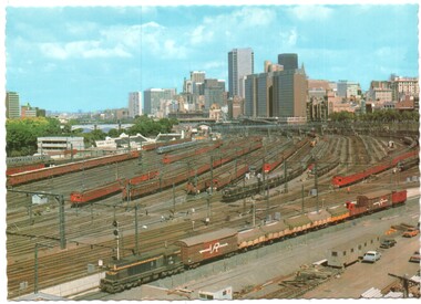
... Shows an aerial view looking west over the Flinders St... Shows an aerial view looking west over the Flinders St railway ...Shows an aerial view looking west over the Flinders St railway yards and the city skyline. Photo shows the Swimming centre in Batman Ave, the Victorian Railways Metrol signal control building and the large yard with Tait, Harris and a silver train. On the left is the overhead wiring train A goods train lead by a flat top T class is passing in the lower part of the photo. In the 1980s the yards were redeveloped to provide the Tennis Centre, partly roofed at the western end and a new bridge over the yard at Exhibition St that replaced the tram track in Batman Ave and the Princes Bridge terminus.Yields information about the Flinders Railway Yard prior to redevelopment.Postcard - Flinders St Rail Yard and city - Serrated edges - Divided back BG83railways, victorian railways, railway yard, flinders st, suburban trains, melbourne -
 Melbourne Tram Museum
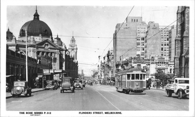
Postcard, Rose Stereograph Co, "Flinders Street Melbourne", late 1930s
... Melbourne", looking west along Flinders St from about the Ball...", looking west along Flinders St from about the Ball and Welch ...Rose Series postcard No. P 312, titled ""Flinders Street Melbourne", looking west along Flinders St from about the Ball and Welch building. Has W2 class tram No. 239 (Hawthorn Route 27) east bound. On the left Is the Princess Bridge Railway Station and Flinders Street Railway station. In the background is the Fish Market and the railway viaduct. On the right is St. Paul Cathedral, Princess Bridge Hotel, Sargood Gardiner Limited Wherehouse plus the recently opened (1936) Snows Department Store. Note the tramway overhead of the curve outside Flinders Street Railway station. Yields information about Flinders St late 1930s.Postcard - printed real photograph with Rose Stereograph Co. name on the rear. Two copies held.tramways, trams, flinders st, tram 239, w2 class, flinders st station, princes bridge station, route 27 -
 Charlton Golden Grains Museum Inc
Photograph
... Mounted, sepia toned photograph of High St Charlton looking... looking north west. Buildings left to right: residence, Mechanics ...Early photograph of the west end, northern side of High St Charlton 1880's. Globe Hotel built 1874, Mounted, sepia toned photograph of High St Charlton looking north west. Buildings left to right: residence, Mechanics Institute, general store, shop, Stowe's fruit & veg shop, Globe Hotel, bank (?), T.H. Jackson butcher, O'Sullivan Paintermechanics institure, stowes, globe hotel, t.h.jackson butchers, o'sullivan painter, high street, charlton -
 Eltham District Historical Society Inc
Negative - Photograph, J.A. McDonald, Henley Road at Watsons Creek, Apr. 1961
... Henley Road at Watsons Creek looking westerly showing west... melbourne Henley Road at Watsons Creek looking westerly showing west ...Henley Road at Watsons Creek looking westerly showing west abutment excavation Mid April 1961Record of various Shire of Eltham infrastructure works undertaken during the period of 1952-1962 involving bridge and road reconstruction projects, sometimes with Eltham Shire Council Project Reference numbers quoted. It was during this period that a number of significant improvements were made to roads and new bridges constructed within the shire that remain in place as of present day (2022). In many situations, the photos provide a tangible visible record of infrastructure that existed throughout the early days of the Shire. The album was put together by or under the direction of the Shire Engineer, J.A. McDonald.infrastructure, shire of eltham, bend of islands, cr. charis pelling, henley road, henley road bridge, kangaroo ground, oxley bridge, watsons creek, w.e. wolf, bridge construction, road construction, 1961-04 -
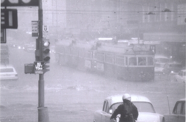 Melbourne Tram Museum
Photograph - Set of 9 Black & White Photograph/s, Ray Marsh, CBD Melbourne in 17 Feb. 1972 - floods, 1970's
... , Little Collins and Swanston St looking west. Has a sign... of the downpour. .2 - ditto, after the rain - looking east, with Dunklings ...Set of seven black and white photographs of Ray Marsh, of the flooding that occurred in the centre of the CBD Melbourne in 17 Feb. 1972. See Timeline History of Melbourne Trams - Barry George et al. .1 - 876 and two other trams, inbound, Bourke - Elizabeth at the height of the downpour. .2 - ditto, after the rain - looking east, with Dunklings in the view. .3 - W2, route 49, Little Collins and Swanston St looking west. Has a sign advertising Bush walking and sporting equipment above. .4 - W2 591 - north bound in Elizabeth St Essendon, route 49 looking south at corner of Collins St. Digital image of The Age article for the event supplied by Mal Rowe 4/12/12 by e-mail. 2nd copies of .2, .3 and .4 added ex donation of Keith Kings. .7 - Looking south from Bourke St / Elizabeth St. .8 - Bourke St at Elizabeth St with W6 976 and 992 in Bourke St on their way to Spencer St. .9 - Line up of trams in Bourke St (looking west) tailed by W6 999,. route 88. - two copies held. See Reg Item 5995 for photos of Flinders St at Market St. and 6099 for other photos.Details of the event written on the back of photos collected by Keith Kings and the Ray Marsh stamp in green ink with his address details.trams, tramways, melbourne, flooding, elizabeth st, bourke st, tram 876, tram 591, tram 976, tram 992, tram 999 -
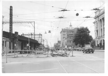 Melbourne Tram Museum
Photograph - Set of 12 - construction of King St overpass in Flinders St, 1959
... . It was demolished in 2005. 1 - looking west at Market St. 2 - looking east.... It was demolished in 2005. 1 - looking west at Market St. 2 - looking east ...Photos show the construction of King St overpass in Flinders St which was part of the project to construct a bridge over the Yarra River and provide a new southern outlet road between the city and eventually St Kilda Junction. The overpass construction was commenced in 1959 with tramway works first commencing. It was demolished in 2005. 1 - looking west at Market St. 2 - looking east from Spencer and Flinders St with the railway viaduct behind. 3 - Tram lines diverted onto the new overpass. Note the hand-powered overhead tower on the left behind the compressor. 4 - Tracks partially diverted. 5 - Looking east at Spencer and Flinders St with a Dunlop tyre truck in the view. 6 - prior to the diversion onto the new bridge. 7 - Looking east near William St. with W2 451 (Route 48, North Balwyn) in the view. 8 - Bridge works near King St. Original tracks still in use. 9 - Looking east prior to the introduction of the temporary tracks on the south side of the new overpass. 10 - SW6 852 and a W2 on new overpass trackwork - old trackwork being demolished. 11 - Cross over at Spencer St in Flinders St, prior to change over. 12 - Looking west at Flinders and Spencer St with SW6 853 turning into Spencer St.Yields information about the construction of the King St overpass in Flinders St during 1959.Set of 12 black and white prints of the construction of the King St overpass in Flinders St.trams, tramways, flinders st, king st overpass, construction, bridges, w2 class, sw6 class, tram 451, tram 853, tram 852 -
 Port Melbourne Historical & Preservation Society
Photograph - Port Melbourne foreshore, Lyn Allison, Nov 1992
... , looking east and west from and toward Lagoon Pier. Taken by Cr Lyn... Melbourne foreshore, looking east and west from and toward Lagoon ...From a series of photos taken by Lyn Allison, then a counmcillor of the city of Port Melbourne, to record the condition of Port Melbourne's beachesLasercopy of two photos of Port Melbourne foreshore, looking east and west from and toward Lagoon Pier. Taken by Cr Lyn Allison, Nov 1992.built environment - civic, natural environment - beaches and foreshore, lyn allison