Showing 1973 items
matching marshall
-
 Ringwood and District Historical Society
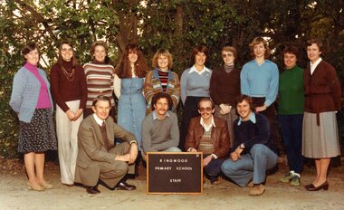
Photograph, Ringwood State School - Staff, 1979
Colour photograph - Staff, 1979"Attached to photograph" Back Row-L to R: Jeanette Cole, Judith Featherby, Doreen Turner, Rosemary Hill, Elizabeth Hrovda, Dianne Jones, Maureen Gray, Joanne Lawrence, Dawn Colville, Isabel Marshall. Front Row-L to R: Baden Chadwick (Principal), Stephen Gough, Tom Esala, Bruce Bower. -
 Eltham District Historical Society Inc
Photograph - Digital Photograph, Alan King, Nillumbik Shire Offices, Greensborough, 30 March 2008
Nillumbik Shire Council transferred to the former Diamond Valley Shire Offices in Greensborough after municipal restructuing. The offices became the official Nillumbik Shire Council Offices on 16 October 1995. The former Shire of Diamond Valley Civic Centre or Shire Office building was officially opened on 26th February 1972. Archtiects were A.K. Lines, McFarlane & Marshall and it was built by L.U. Simon Pty Ltd, The Diamond Valley Shire had been created in 1964 from part of the City of Heidelberg. On December 15, 1994 the Shire of Nillumbik was established. Under the Council amalgamations imposed by the Kennett government, the Shire of Eltham, Shire of Diamond Valley and City of Heidelberg ceased to exist with the establishment of Nillumbik Shire Council and the City of Banyule.The new Nillumbik shire surrended the west riding from Eltham to Banyule but in place gained parts of the former Diamond Valley Shire which itself had been created in 1964 from parts of the City of Heidelberg. Three unelected and non-local Commissioners were put in place by the government bringing democracy into question by many members of the local community. The Commissioners determined to abandon the former Shire of Eltham offices located in Main Road, Eltham and in turn occupy the former Shire of Diamond Valley offices located at the boundary of the new shire with Banyule, in Civic Drive, Greensborough. In July 1996 the Commissioners sold the former Eltham Shire Offices and had them bulldozed leading to many years of communiity protest over the process and future development applications. The site has remained vacant ever since. Published: Nillumbik Now and Then / Marguerite Marshall 2008; photographs Alan King with Marguerite Marshall.; p43 It was the need for roads that led to this district’s first council. In 1853 a committee was formed to improve the rough roads, some in Kangaroo Ground being almost impassable in winter.1 The committee fundraised by voluntary levies and grants to improve in particular, the main road between Kangaroo Ground and the Plenty River. From this committee arose the Eltham District Road Board, in 1856, which was the precursor to the Eltham Shire Council. The Board’s first chairman was Kangaroo Ground farmer, John Barr. Secretary was the former committee’s secretary, Andrew Ross, Kangaroo Ground’s first school teacher, and founder of the district newspaper, The Evelyn Observer.2 Most of the board’s income came from a toll-house north of the Lower Plenty Bridge, which funded such projects as a road from Kangaroo Ground to the Caledonia Diggings. In 1871 the Shire of Eltham was proclaimed, with its boundaries the same as those of the Road Board, and Councillor A Donaldson of Kangaroo Ground was the first president. Eltham was at the southern tip of the shire, which extended north to Kinglake and east beyond Yarra Glen. In 1878, part of Kinglake was added to the shire, while the area east of Watts River, near Healesville was removed. In 1912, then again in 1958, the shire was further reduced. Yarra Glen, Steels Creek, Tarrawarra, parts of Healesville and Christmas Hills, were transferred to the Shire of Healesville. In 1972 a smaller area, at Kinglake, was transferred to the Shire of Yea, leaving 277 square kilometres in the Eltham Shire. Perhaps no other Victorian municipality has had so many meeting places. Although from 1858 to 1904, the council convened at the office in the home of Secretary Charles Wingrove, the board, and later the council, also met at other more central locations.3 The board moved from the Fountain of Friendship Hotel to the Eltham Courthouse, to the Kangaroo Ground schoolhouse. It then met at the Kangaroo Ground Hotel, which some considered put it in danger of interruptions by people ‘the worse for liquor’.4 In 1885 the council met at the hall on Mr J Donaldson’s land at Kangaroo Ground. After Wingrove’s retirement, the council rented space at the Kangaroo Ground General Store and Post Office. Then, in 1917, the council bought the former office of The Evelyn Observer, after its printing works transferred to Hurstbridge. In 1934, fire destroyed the shire office, which was temporarily relocated to the Kangaroo Ground home of Shire Secretary, Mr P J McMahon. In 1941, the shire office moved to a new building (which included a public hall) in Eltham, at the corner of Arthur Street and Main Road, where the Eltham Village Shopping Centre was eventually built. Growth required new offices, which opened in 1965, on the former Shillinglaw property in Main Road.5 In 1994, as part of municipal restructuring under the Jeff Kennett Liberal Government, most of the Eltham Shire formed part of the new Shire of Nillumbik. It joined with the north section of the Diamond Valley Shire and parts of the Healesville and Whittlesea municipalities. The Diamond Valley Shire had been created in 1964, from part of the City of Heidelberg. Turbulence followed Nillumbik Shire’s formation. Under the Commissioners the council transferred to the former Diamond Valley Shire offices in Greensborough, and the Eltham council offices were demolished. In March 1997 the first five-member Nillumbik Council was elected. But, in October 1998, the government suspended the council and appointed an administrator . Early in 1999, shire residents voted to increase councillors to nine: comprising five ward councillors and four shire-wide councillors. Elections were held in March 1999. Then, before the March 2002 elections, nine new wards were created.6 In 2008 these were reduced to seven. Today [2008] the council governs a varied population of more than 60,000 people living in townships and on bush properties in the green wedge.This collection of almost 130 photos about places and people within the Shire of Nillumbik, an urban and rural municipality in Melbourne's north, contributes to an understanding of the history of the Shire. Published in 2008 immediately prior to the Black Saturday bushfires of February 7, 2009, it documents sites that were impacted, and in some cases destroyed by the fires. It includes photographs taken especially for the publication, creating a unique time capsule representing the Shire in the early 21st century. It remains the most recent comprehenesive publication devoted to the Shire's history connecting local residents to the past. nillumbik now and then (marshall-king) collection, greensborough, nillumbik shire council offices, civic drive -
 Ringwood and District Historical Society
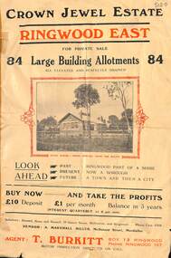
Flyer, Subdivisional Land Sale Brochure, Crown Jewel Estate, Ringwood East, Vic. - c.1925
In May 1884, George Smart of Bulleen Road Kew, brickmaker, bought the 23 acres one rood and twenty nine and three tenths perches, or 9.4834 hctares from Arthur Bailey Clements of Ringwood for the sum of 600 pound sterling. (Extract from The Story of the Crown Jewel Estate in Ringwood East pdf)Double sided folded page with black and red print on both sides advertising auction sale of residential and business sites and highlighting local facilities, services and layout of the estate.Subdivision includes Mount Dandenong Road, Valda Avenue, Evon Avenue, Mirabel Avenue, and Velma Grove. (Agent) T. Burkitt, Box 12 Ringwood, Phone Ringwood 157. Vendor: A. Marshall Miller, McDonald Street, Mordialloc. Solicitors: Russell, Bona and Russell, 19 Queen Street Melbourne, and Ringwood - Phone Cent. 4308. -
 Ringwood and District Historical Society
Photograph, Ringwood State School - Teachers, 1977
Black and white photograph - Teachers, 1977."Attached to photograph" L to R: Doreen, Joan Schofield (Special Migrant Teacher), Isobel Marshall, Baden Chadwick, Diane Barthing, Noelle Hill, Susan Morris, Mary Wedlar, Len Hadfield, Diane Chitty, Monica Harman, Mandy Thatcher, Anneli Symons, Sherry (?), Liz McCallum, Ailsa Dennis, Rosemary (?), Anne (?), Pam Greenwood. -
 Ringwood and District Historical Society
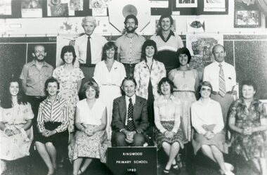
Photograph, Ringwood State School - Staff, 1980
Black and white photograph - Staff, 1980"Attached to photograph" Back Row- L to R: John Duffy, Stephen Gough, Bruce Bower. 2nd Row- L to R: Tom Esah, ?, ?, Joanne Lawrence, Diane Barthing, Ken Foreman. Front Row- L to R: Rosemary Mandemacher, Isabel Marshall, ?, Baden Chadwick, Marj Smith, Maureen Gray, Margaret Beuthin. Teacher: -
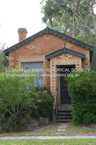
 Eltham District Historical Society Inc
Photograph - Digital Photograph, Alan King, Former Police Residence, 728 Main Road, Eltham, 28 December 2007
The institutions of law and order in Colonial Victoria included the police, courts and prisons. The 1852 report of the Snodgrass Select Committee appointed to "identify the policing needs of the colony” noted there existed seven independent police forces that did not co-operate or regularly communicate. Following the committee's report all these police entities were merged into the Victoria Police, founded on 8 January 1853, to implement law and order responsibilities throughout the Colony of Victoria. The Eltham Courthouse (1860) and adjacent Police Residence (1859) formed a justice precinct established in the immediate aftermath of the 1852 police inquiry and the effects of the gold rush. The physical presence of these buildings, in the centre of the early Eltham township, defined centralised control over law and order. In the early days the Police Constable in charge would conduct his duties travelling around the district by horse; a stable was located at the rear of the residence. At times the horse would be grazed on the paddocks across the road. Horseshoes were forged by the blacksmith beside the Courthouse on the high side of “Policeman’s Hill”. Along with the stable, there was a two-cell bluestone lockup where prisoners were held awaiting trial in the adjacent Courthouse. Their meals were usually provided by the policeman’s wife or from the hotel just up the road. With the arrival of the railway in 1902 the town centre gradually shifted towards the railway station. The Police Station and operations were moved into the town centre in 1961 to a renovated house in Pryor Street, which was later replaced by the current Police Station. From 1961-1981 the residence was occupied by the Vermin and Noxious Weeds Destruction Section of the Department of Crown Lands and Survey. Prior to August 1967 the former Police Station was dragged to the rear of Police Residence to make way for the construction of a driveway and access from Main Road. The building was placed on the site of a former Scullery and modified for Lands Department use. In 1981 the Shire of Eltham took over management of the former Police Residence in Eltham. It remained unoccupied for a period whilst its future was discussed in Council. It was then used for a community job creation scheme until 1985. In 1985 the Shire of Eltham Parks and Environment occupied the residence. Council improved the driveway but later added a second rear access from Brougham Street due to the dangerous nature of the Main Road entrance. Additionally, a rear toilet facility between the Police Residence and the relocated former Police Station, which was doubling up as a lunchroom. Council also commenced discussions to re-establish a replica Police Station. Around November 1986 the former Police Station was demolished; believed to have been suffering termite damage. About 1989, after some years of discussion, a replica Police Station was built, based on photographs, to act as a lunchroom and meeting room for the Parks and Environment staff and volunteers doing community service. In 1996 Eltham District Historical Society held discussions with Nillumbik Shire Council commissioners throughout the year regarding a home for the Society. A proposal was put forward by the Society in October to occupy the former Police Residence. In March 1997 Eltham District Historical Society gained access to former Police Residence and on July 12, 1998, moved into its Local History Centre. In July 2018, Eltham District Historical Society gained access to the replica Police Station (which had been used as a music library and storage for the Eltham Concert Band) for use as part of regular heritage tours for schools and community-based groups. Covered under Heritage Overlay, Nillumbik Planning Scheme. Published: Nillumbik Now and Then / Marguerite Marshall 2008; photographs Alan King with Marguerite Marshall.; p65This collection of almost 130 photos about places and people within the Shire of Nillumbik, an urban and rural municipality in Melbourne's north, contributes to an understanding of the history of the Shire. Published in 2008 immediately prior to the Black Saturday bushfires of February 7, 2009, it documents sites that were impacted, and in some cases destroyed by the fires. It includes photographs taken especially for the publication, creating a unique time capsule representing the Shire in the early 21st century. It remains the most recent comprehenesive publication devoted to the Shire's history connecting local residents to the past. nillumbik now and then (marshall-king) collection, eltham, main road, eltham district historical society, eltham justice precinct, little eltham, local history centre, police residence, police station -
 Eltham District Historical Society Inc
Photograph - Digital Photograph, Alan King, Allwood House, Hurstbridge, 16 April 2008
Allwood - built in 1894 by Henry Hurst’s relatives, stands near the site of his house, which was demolisherd in the 1940s. Until 1924 Hurstbridge was known as Allwood. The building, one of the district's oldest is situated back from the corner of Arthurs Creek Road and Main Road. Covered under Heritage Overlay, Nillumbik Planning Scheme Published: Nillumbik Now and Then / Marguerite Marshall 2008; photographs Alan King with Marguerite Marshall.; p17 Hurst, who was a surveyor, came to Melbourne in 1852 by default, as on the way to Sydney he contracted typhoid and was off-loaded in Melbourne. Deciding to settle near Melbourne, he selected some land near the present Eltham railway station and was one of the first to grow crops there.2 But disaster struck again, when his shack was looted and burned, while he was carting goods for sale to nearby goldfields. It was then that Hurstbridge’s first settler, Cornelius Haley, asked Hurst to manage his 160 acres (65ha) grazing property and 9000 acres (3443ha) of leased land where the present Hurstbridge stands. Hurst proved equal to the tough conditions and he and his brother, Fred, cut a track with a bullock team from the property to Romsey, where Haley had selected some land. Hurst also put up a bridge across the creek near his house, after which Hurstbridge was named. He ran the property helped by two ticket-of-leave men and others, several of whom were sailors who had abandoned ship in search of gold, and were working there temporarily. In 1866, only 14 years after coming to Australia, Hurst met an early tragic death. One day a bushranger named Burke came to the house and demanded a horse. Hurst thought the bushranger might be an officer in search of runaway sailors3 and anyway, did not like the look of him, so he refused. A tussle followed and apparently Hurst shot first.4 He was shot and died five hours later from loss of blood. Later, troopers found Burke, who was subsequently hanged. The event is recorded in the Old Melbourne Gaol. The government offered the family £500 but the family refused it as ‘blood money’. Hurst’s father, Robert, even signed a petition against the bushranger’s death, claiming one life did not replace another. Hurst’s family continued to live in the district and saw a rise in their fortunes. They bought Haley’s cattle station and built the present Allwood House, using the original home as an orchard packing shed. The present Victorian style timber house had several outbuildings including a blacksmith’s shop. The property passed on to William Gray, an orchardist and nurseryman, who married Hurst’s grandniece, Frances. The business boomed from the early 1900s when it supplied most of the orchards in the area. Gray was Eltham Shire’s President for two terms and was asked to stand for parliament, but his wife’s illness and other family commitments prevented him from doing so. Then several calamities drove the family to bankruptcy. During World War One, Gray lost more than one million pounds on trees shipped overseas, which the Lloyd’s company had refused to insure. Other factors, including the Great Depression, ruined the family’s fortunes. The land was reduced from more than 640 acres (256ha) to 50 acres (20ha) and the older members married and left. After Mr Gray died, the house was leased, until his daughter Sheila Ferguson and her husband Gordon settled there in 1951, after buying it from other family members. However in 1975 the Shire designated the property as a passive recreation reserve. The Ferguson family sold most of the land, leaving the house on 0.6 hectares.This collection of almost 130 photos about places and people within the Shire of Nillumbik, an urban and rural municipality in Melbourne's north, contributes to an understanding of the history of the Shire. Published in 2008 immediately prior to the Black Saturday bushfires of February 7, 2009, it documents sites that were impacted, and in some cases destroyed by the fires. It includes photographs taken especially for the publication, creating a unique time capsule representing the Shire in the early 21st century. It remains the most recent comprehenesive publication devoted to the Shire's history connecting local residents to the past. nillumbik now and then (marshall-king) collection, hurstbridge, henry hurst, allwood house -
 Eltham District Historical Society Inc
Photograph - Digital Photograph, Alan King, Shillinglaw Cottage, 6 January 2008
Covered under National Estate, National Trust of Australia (Victoria) Local Significance and Heritage Overlay, Nillumbik Planning Scheme. Published: Nillumbik Now and Then / Marguerite Marshall 2008; photographs Alan King with Marguerite Marshall.; p95 Thanks to an Australia first effort by local residents, the historic Shillinglaw Cottage still survives. The cottage at Panther Place, Eltham, once stood about 100 metres away on Main Road. But in 1963 it faced demolition to make room for the Eltham Shire Offices (since demolished). However residents rallied to save Shillinglaw Cottage and became the first in Australia to remove and reconstruct an early settler’s brick building. A fundraiser was the residents’ compilation of loved recipes into the cookery book, Flavour of Eltham. The cottage, built in the late 1870s by noted pioneer builder George Stebbing, is one of Eltham’s earliest buildings and associated with significant early settlers. It is on the National Estate and National Trust Registers. The cottage was constructed with handmade bricks in the Flemish Bond style, typical of cottages and farmhouses in Flanders, Europe. It features burnt ‘header’ bricks over the façade, which gives a chequered effect. The roof is made of slate, while the windows are 12-paned sash with relieving arches. It is not clear who were the first owners of the cottage. The National Trust claims that Stebbing built it for farmer Thomas Cochrane.1 Others say Cochrane first owned the land but Stebbing was Shillinglaw’s first owner and remained so until 1887. The Shillinglaw family then bought it and lived there for around 80 years until 1963 when they sold it to the Eltham Council.2 Farmer Thomas Cochrane bought the Shillinglaw Cottage site from land developer Josiah Holloway. The site was the largest in what Holloway called Little Eltham, of some 30 acres (12 ha), extending along the creek from Henry Street to Luck Street. In 1874 Cochrane sold the land to George Stebbing. Meanwhile in 1861, Stebbing was the owner and occupier of a house at Pitt Street, Eltham, which he had built. Evelyn Observer journalist James Rossiter rented the Pitt Street house, then in 1881 Phillip Shillinglaw occupied it. Stebbing constructed several buildings of note in the area, including the Uniting Church at John Street, the building beside it – a former bank – and St Margaret’s Church of England in Pitt Street. Stebbing was also an Eltham Shire Councillor from 1871 to 1873 and a trustee and treasurer of the Eltham Wesleyan Church.3 In the 1870s he is recorded as the owner of up to five houses. Earlier he had been described as a bricklayer and later became a farmer. In 1882 Stebbing returned to the Pitt Street house and Shillinglaw occupied the new house in Main Road, which he owned from 1887. Shillinglaw was a prolific poet and preached at the Eltham Primitive Methodist Church, where he also served as Sunday School superintendent and led the Young People’s Society Christian Endeavour. The Shillinglaws saw many changes in their property’s boundaries – the major one occurring at the turn of the century when land for the railway and Eltham station was acquired from their holding. The northern part of the remaining land was then used for some of the first commercial developments in what was to become the Eltham Shopping Centre. Later still, the land immediately north of the cottage was bought by the Eltham War Memorial Trust for the War Memorial Buildings and the fire station. The Trust’s land eventually passed to the council. The council bought the remaining two acres (0.8 ha) with the house, and with the exception of the commercial development between the fire station and the post office, all of the former Shillinglaw land is owned by the council or government instrumentalities.4 Since the late 20th century, the cottage has had varied uses, such as a handcrafts store and as a restaurant.This collection of almost 130 photos about places and people within the Shire of Nillumbik, an urban and rural municipality in Melbourne's north, contributes to an understanding of the history of the Shire. Published in 2008 immediately prior to the Black Saturday bushfires of February 7, 2009, it documents sites that were impacted, and in some cases destroyed by the fires. It includes photographs taken especially for the publication, creating a unique time capsule representing the Shire in the early 21st century. It remains the most recent comprehenesive publication devoted to the Shire's history connecting local residents to the past. nillumbik now and then (marshall-king) collection, shillinglaw cottage -
 Eltham District Historical Society Inc
Photograph - Digital Photograph, Alan King, Former CBA bank, Main Road, Eltham, 26 January 2008
This tiny picturesque building near the corner of John Street has served the community since 1878. At that time it served as an agency of the Heidelberg branch of the Commonwelath Bank of Australia. It has a small space inside measuring about 3.6 metres by 4.5 metres. It was built by George Stebbing who was also responsible for other heritage buildings nearby in Eltham. Covered under Heritage Overlay, Nillumbik Planning Scheme. Published: Nillumbik Now and Then / Marguerite Marshall 2008; photographs Alan King with Marguerite Marshall.; p93 The tiny picturesque building on Main Road, Eltham, near the corner of John Street, has served the community since 1878. At that time the building, which inside measures only about 3.6m by 4.5m served as an agency of the Heidelberg branch of the Commercial Bank of Australia. The yellow and orange Victorian brick structure was built by Mr George Stebbing.1 Mr Stebbing, who also built the Anglican and former Methodist churches and the Shillinglaw Cottage, had come from England and lived in Pitt Street. The bank is a fine example of a once common but now rare building style – the single room bank. It compares with another in the municipality, also a former Commercial Bank of Australia branch, the timber Little Bank Building in Hurstbridge, built around the early 1900s.2 The Eltham bank, which was said to store gold from the Eltham - Research mining areas, has had exciting moments. A bullet hole still visible in a cedar bench testifies to the drama in 1949 when a youth held up the bank. After the 19-year-old opened an account as John Henderson, he walked to the door and then turned pointing a pistol. But it was shots fired by the clerk, Lindsay Spear, that saved the day, frightening the youth, who drove off empty-handed in a grey sports car. He was later apprehended and given a two-year sentence. Soon afterwards the agency was upgraded to a branch. However by 1954 the bank no longer needed the branch and the adjoining Methodist Church bought the building. It proved useful for the Church’s young people who furnished it and used it for their meetings. A youth club developed, led by young adult member, Ross Gangell. The building was also used as a Sunday School, which with junior membership numbered 27.3 Around 1960, Mrs Alma Bell, of the Methodist Church Women’s Guild, suggested using the building as an opportunity shop to raise funds for a chaplain at the Eltham High School. The women later asked the nearby St Margaret’s Anglican Church to help them in the shop. In 1960 the Eltham Combined Churches Opportunity Shop was established and staffed by Methodist and Anglican parishioners, notably Methodist Mrs Gwen Miller. The shop originally opened on Child Endowment Days to help the needy, but later for years, it opened twice a week. In 1962 it donated clothing and shoes to the Eltham Bushfire Appeal. By 1963 the chaplaincy scheme ceased. So the £450 raised was then donated to the Council for Christian Education and to the participating churches. Funds were also donated to local charities including the Eltham and Research Fire Brigades, the Austin Hospital Auxiliary, the Benevolent Society, the Red Cross and the Diamond Valley Hospital.4 In 2008 the Opportunity Shop volunteers continue to work together to help the local community. Although crammed with second-hand goods, the simple, almost stark interior, is still evident and is relieved only by a front rectangular window and an unused fireplace. Outside, the chimney, the corrugated iron peaked roof, and the surrounding varied plants, add to the charm of this sound building which continues to serve the community well.This collection of almost 130 photos about places and people within the Shire of Nillumbik, an urban and rural municipality in Melbourne's north, contributes to an understanding of the history of the Shire. Published in 2008 immediately prior to the Black Saturday bushfires of February 7, 2009, it documents sites that were impacted, and in some cases destroyed by the fires. It includes photographs taken especially for the publication, creating a unique time capsule representing the Shire in the early 21st century. It remains the most recent comprehenesive publication devoted to the Shire's history connecting local residents to the past. nillumbik now and then (marshall-king) collection, cba bank -
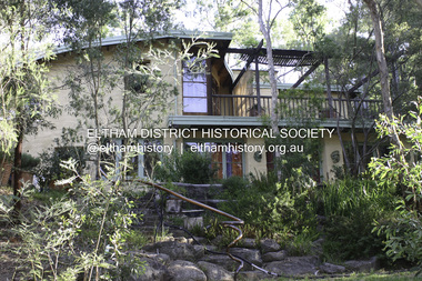 Eltham District Historical Society Inc
Photograph - Digital Photograph, Alan King, Busst House, cnr Silver Street and Kerrie Crescent, Eltham, 2 February 2008
Considered the best of the early mud-brick houses built by Alistair Knox. Covered under Heritage Overlay, Nillumbik Planning Scheme. Published: Nillumbik Now and Then / Marguerite Marshall 2008; photographs Alan King with Marguerite Marshall.; p143 The Busst house hidden by trees at the corner of Silver Street and Kerrie Crescent is considered the best of the early mud-brick houses built by Eltham architect, Alistair Knox. Knox himself said, that the Busst house was the most mature mud-brick house designed at that period. ‘It related with true understanding to its steep site and expressed the flexibility of earth building ………to develop a new sense of flowing form and shape’. Built in 1948 for artist Phyl Busst, a former art student at Montsalvat, the house helped usher in Eltham Shire’s distinctive mud-brick residential character. Knox was the pivotal figure of the style developed from the 1950s to the 1970s. Scarcity of building materials after World War Two encouraged mud-brick building because earth was a cheap and plentiful building medium. But when Knox began building in mud-brick in 1947, no council in Victoria knew anything of this ancient art and he needed a permit. Fortunately the Commonwealth Experimental Building Station at Ryde in NSW, had been experimenting with earth construction to help overcome the shortages of that time. They published a pamphlet that became available in Melbourne on the same day the Eltham Council was to consider whether the earth building should be allowed. Knox caught one of the three morning trains to the city in those days and bought several copies of the pamphlet to give to each councillor. On his return he found the councillors standing on the steps of the shire offices after lunch at the local hotel. He heard that earth building had been discussed before lunch and that they were not in favor of it. Knox gave each councillor a pamphlet. They passed that plan and by doing so, opened the door for all future earth building in Victoria and by default, in Australia. Mud-brick houses attracted artists to Eltham, for their aesthetic appeal and because they were cheap. Those who built their own houses, included film maker Tim Burstall, artists Peter Glass, Clifton Pugh, Matcham Skipper, Sonia Skipper and husband Jo Hannan. For Knox, mud-brick building was more than just a cheap building medium. He saw it as harmonising with the surrounding bush and as a way of counteracting the growing materialism of the age. He wrote of its impact on ‘ 20th century man. It should counteract the confusion that the perpetual flow of high technology products have upon him ..’ Building the Busst house on a steep site was difficult because most earth-moving equipment was then in its infancy. For instance drilling for explosives was done by hand, which was a slow and painful process. Knox, assisted by his foreman Horrie Judd and Gordon Ford (who was to become a famous landscape designer), built two large main rooms - a living room/ kitchen downstairs - and upstairs, a studio/bedroom. The studio/bedroom opens onto the balcony, which covers the living area. The bath made of solid concrete by stonemason Jack Fabro, is particularly deep. Sunshine pours through the three French windows of the north-east facing kitchen/living area, which is lined with timber. The large hearth can fit a family around the fire while the timber floors and solomite (compressed straw) ceilings add to the cosy atmosphere. The garden is thick with trees, and in the late 1990s, Ford put in a pool near the original dry wall he had built as a young man.This collection of almost 130 photos about places and people within the Shire of Nillumbik, an urban and rural municipality in Melbourne's north, contributes to an understanding of the history of the Shire. Published in 2008 immediately prior to the Black Saturday bushfires of February 7, 2009, it documents sites that were impacted, and in some cases destroyed by the fires. It includes photographs taken especially for the publication, creating a unique time capsule representing the Shire in the early 21st century. It remains the most recent comprehenesive publication devoted to the Shire's history connecting local residents to the past. nillumbik now and then (marshall-king) collection, alistair knox, alistair knox design, busst house, kerrie crescent, mudbrick construction, mudbrick houses, silver street -
 Eltham District Historical Society Inc
Photograph - Digital Photograph, Alan King, Alistair Knox Park, Eltham, 2008
Alistair Knox Park, an oasis of peace and beauty. Covered under National Trust of Australia (Victoria) Landscape Significance and Heritage Overlay, Nillumbik Planning Scheme. Published: Nillumbik Now and Then / Marguerite Marshall 2008; photographs Alan King with Marguerite Marshall.; p173 It is hard to imagine that the Alistair Knox Park, an oasis of peace and beauty beside busy Main Road, Eltham, was once the township’s rubbish dump. It was only in the 1970s that the tip was transformed into this beautiful six hectare space, which later earned it a National Trust Landscape classification. Before its life as a dump, the area was used for small farms. Thanks largely to the foresight and efforts of local environmental builder Alistair Knox, the park was designed sympathetically with the character of the wider Eltham landscape. Then, appropriately, the park was named after Knox, who was an Eltham Shire Councillor from 1971 to 1975 and Shire President in 1975. The park designers were four major forces in the urban bush landscape garden –Knox, landscape designer Gordon Ford, artist Peter Glass and landscaper Ivan Stranger. The National Trust citation for the park, originally called Eltham Town Park, includes the Eltham railway trestle bridge and the Shillinglaw Cottage. The citation states ‘the semi-natural setting of the parkland provides a landscape which is evocative of the history of the area’. Manna Gums (Eucalyptus viminalis) and Candlebarks (Eucalyptus rubida) are significant features. Most of the park’s construction was directed by Bob Grant, Superintendent of the Parks and Gardens Department for the Eltham Shire Council. First plantings occurred in Arbour Week in 1973, then the lake and botanic area were completed in 1975, with Federal Government funding, and the toilet block in 1978. Bounded by the Eltham railway line, Panther Place, Main Road, Bridge and Susan Streets, the park is in a valley about a kilometre wide overlooked by steep hills at the east and west. The Diamond Creek flows through it and the picturesque historic timber trestle railway bridge edges the north. Informal plantings of Australian indigenous and native species in open and undulating grassed settings blend with the natural landscape of the Diamond Creek to the west. The bush-style plants, particularly around the creek, balance with open lawns, paths and a cascade flowing from a small lake to another below. A footbridge over the creek leads to the park’s west. The park includes an adventure playground and barbecue areas. The park stands on part of the land bought from the Crown in 1851 by Josiah Holloway, who subdivided it into allotments and which he called Little Eltham. Most of the land was subdivided into residential lots, but the creek valley, on which the park stands, was subdivided into farm-size lots, used mainly for orchards and grazing. One of the earliest owners was John Hicks Petty, who in 1874 bought a plot from Holloway. Other families who owned properties in that area, included Rees, Clark, Waterfall, Graham, Hill and Morant. In 1901 the railway was built through the area. Jock Read, an Eltham resident since around 1920, remembers several farms in the 1920s and ’30s that occupied the site of today’s park. A poultry farm, which extended from present day Panther Place, was owned by the Gahan family. Next to that farm was another for grazing cattle owned by Jack Carrucan. Beside this was land owned by John Lyon. A doctor lived beside this, and at the north-west corner of Bridge Street and Main Road stood a memorial to the soldiers who died in World War One, which was later moved to the RSL site. Mr Read also remembers other farms and orchards west of the creek In the early 1960s the Eltham Council began buying these farms and in the late 1960s turned the areas east of the Diamond Creek into a garbage tip. When this was filled above the creek’s flood plain, the tip was moved to the west of the creek.This collection of almost 130 photos about places and people within the Shire of Nillumbik, an urban and rural municipality in Melbourne's north, contributes to an understanding of the history of the Shire. Published in 2008 immediately prior to the Black Saturday bushfires of February 7, 2009, it documents sites that were impacted, and in some cases destroyed by the fires. It includes photographs taken especially for the publication, creating a unique time capsule representing the Shire in the early 21st century. It remains the most recent comprehenesive publication devoted to the Shire's history connecting local residents to the past. nillumbik now and then (marshall-king) collection, alistair knox park, eltham -
 Eltham District Historical Society Inc
Photograph - Digital Photograph, Alan King, Sweet Bursaria, 2008
Published: Nillumbik Now and Then / Marguerite Marshall 2008; photographs Alan King with Marguerite Marshall.; p181 The rare Eltham Copper Butterfly, Paralucia pyro-discus, was saved from near extinction by a community campaign in the late 1980s. Thanks to that effort, the butterfly, a form of the Fiery Copper Butterfly, with a wing span of only 2.5cm, can be seen in parts of Eltham and Greensborough from late November to April. As late as 1987 the butterfly was thought to be near extinction. But that year, entomologist, Michael Braby, found several colonies, including two major ones in natural bushland on Diosma Road, Eltham. However these were threatened with destruction, as their habitat was to be destroyed by a development of 71 houses. The colonies were on a 14 hectare subdivision owned by Esanda Finance, an ANZ Bank subsidiary. It would cost around $5 million, to reimburse the bank for the land. The butterfly, which depends on woodland, a stunted form of the Sweet Bursaria bush, and the Notoncus ant, was considered too fragile to relocate. Braby’s discovery led to a sometimes fiery two-year campaign, which even became an election issue. It involved the local community, local and state governments and the developer, before a compromise was reached. The larvae have an intricate relationship with the small black ant, Notoncus. During the day, the larvae shelter in nests made by the ants around the base of the trunk and roots of the Sweet Bursaria (Bursaria spinosa). The ants are thought to protect the larvae from predators and parasites, as they attend them from the nests to feed on the Bursaria leaves at night. In return, the larvae excrete a sugar solution, which the ants love to eat. The butterfly was first recorded in Victoria in 1893, and first collected scientifically from Eltham in 1931. But it was only officially named in 1951, by Victoria’s then top butterfly expert, David Crosby.2 However, from 1970, rapid housing development in Eltham destroyed much of the butterfly’s habitat. The discovery of several major colonies in 1987 met with great excitement, and 250 people attended the first local public meeting. The State Government commissioned Crosby to investigate how to protect the butterfly, and the council froze development for three weeks. Then Esanda agreed to suspend development for several months, until a compromise was reached. Crosby recommended that 62 of the 71 lots be kept to ensure the butterflys’ survival. However this would cost $1 million to $1.5million in compensation to Esanda. Greensborough MP Pauline Toner, launched a $1million fundraising campaign and many artists donated their works to the appeal. Toner offered Clifton Pugh’s painting Eltham Copper Country to millionaire Alan Bond for $1 million, after having heard that he had offered $6 million for the Van Gough painting Sunflowers. However Bond did not accept. The butterfly was considered a ‘hot’ election issue during the by-election, following Pauline Toner’s resignation. Liberal party candidate, Margaret Brown, was accused of falsely saying she had been involved in the butterfly campaign so as to win votes. Sadly, the $1million appeal fell short at $426,000, so a compromise was reached. The State Government donated the Education Department site on Eucalyptus Road, but only nine lots of the Diosma site were bought, and the rest of the development went ahead. On March 3, 1989, Ms Toner died, and the Eucalyptus Road site was named in her honour. Around 2000 the butterfly was further threatened by proposed developments on Pitt Street, facing the Pauline Toner Reserve and between Diosma and Nyora Roads. Fortunately the Friends of the ECB, with the Shire of Nillumbik, ensured that more habitat was made available. The butterfly now survives in seven sites in Eltham and Greensborough, including the main sites at the Pauline Toner Reserve on Eucalyptus Road, the Western and Eastern colonies on Diosma Road, and the Yandell Reserve in Greensborough.The butterfly survives also in Castlemaine and in the Kiata and Salisbury areas. However, it remains endangered.This collection of almost 130 photos about places and people within the Shire of Nillumbik, an urban and rural municipality in Melbourne's north, contributes to an understanding of the history of the Shire. Published in 2008 immediately prior to the Black Saturday bushfires of February 7, 2009, it documents sites that were impacted, and in some cases destroyed by the fires. It includes photographs taken especially for the publication, creating a unique time capsule representing the Shire in the early 21st century. It remains the most recent comprehenesive publication devoted to the Shire's history connecting local residents to the past. nillumbik now and then (marshall-king) collection, eltham copper butterfly, sweet bursaria -
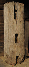 Orbost & District Historical Society
fence post, 1840's
This fence post is from the original Snowy River Station stock yards which were where "Merindah" stands today. It was probably owned by the Marshall family at the time of transfer to "Merindah" in 1985. It was lifted out by Geoff Stevenson with a bucket on a tractor in 1986. The post was originally twice the length. The Snowy River Station was established in 1842 by Peter Imlay. In 1845 the land was sold to Norman MCLeod who named the area Orbost. After financial difficulties in the 1870's the run was taken over by W.J.Clarke and known as Orbost Station.Peter Imlay established the first white settlement in 1842 settling on the eastern side of the Snowy River where the township of Orbost now stands. This settlement was the Snowy River Station. A corner post from a post and rail fence. It is possibly made of red box.. On one side are three rectangular sections cut out with a similar one on the other sides. The post is hollow and has metal staples in the sides for attaching wires.orbost-station mcleod fence-post -
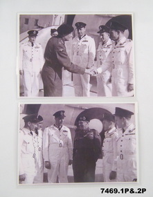 Bendigo Military Museum
Photograph - PHOTOGRAPHS, RAAF 1947, Original 1947
Items in the collection re Jack Mitchell, refer Cat No 7467 for full service details. Field Marshall Montgomery visited Australia in 1947. Jack Mitchell was flying VIP flights. The Berlin Airlift was called "Operation Pelican". The crew. Flt Sgt J.H. Moor No 418451 RAAF, discharged 25.3.1948. Flt Lt O.W, Friend No 406291 RAAF, discharged 5.2.1948 W Com H. C. Plenty No 03103 RAAF, DFC & Bar, discharged 2.2.1976. Flt Lt M Palmer (unknown at this point).1) Photo B & W laminated, shows "Montgomery" shaking hands with Jack Mitchell with 4 other Aircrew around. .2) Photo B & W laminated showing "Montgomery" standing with the same crew. .3) Photo B & W laminated showing the 5 Aircrew with "Montgomery", text at the bottom and on rear.At bottom, "Montgomery of Alamein" On rear, "Monty's crew - L - R - Flt Sgt J.H. Moor - Flt Lt O.W. Friend - W. Com H Plenty - Flt Lt M Palmer - Flt Lt G.J. Mitchell"photographs, montgomery -
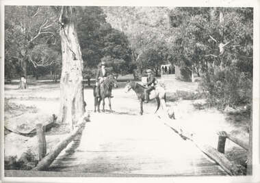 Halls Gap & Grampians Historical Society
Photograph - B/W, C 1920s
The Stoney Creek dray bridge. Stoney Creek has been bridged a number of times on school road since the creek was re-routed in the early 1900s. A dray bridge was built C 1910 by local residents, which stood them in good stead for more than a decade. This bridge was replaced by a higher timber structure. Image two is a story from 1906 relating to Marshall White and his family trying to recross Delley's bridge after finding the Stoney Creek dray bridge washed away.Photo of two men on horseback on a wooden bridge with low log railing. A shelter can be seen in the background and there are thick trees surrounding the road.structures, bridges -
 Melbourne Legacy
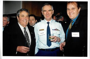
Photograph - Photo, Media Launch 2000, 2000
With other photos that had a Yellow Post-it note says: "Media Launch 2000". See also 00545, 00546 and 00547. But they were a different film number. The other photos were a legatee function in Legacy House with General Sir Peter Cosgrove, AK, MC as a guest speaker. It is assumed to be 2000 as it was with a bunch of other photos with the label, "Media Launch 2000". Legible name tags are: Air Vice Marshall Neil Smith AM. MBE. and Gary Rowe MLA. Other name is Peter Lawrence.A record of function for Legatees. Colour photo x 1 of a gathering at Legacy House to publicise Legacy Week.Printing on the back "legatee event, legacy promotion -
 Federation University Historical Collection
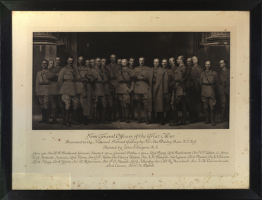
Image, Some General Officers of the Great War by John S. Sargent
Framed reproduction from a painting by John S. Sargent. Left to right: Sir W.R. Birdwood, General Smuts (South Africa), General Botha (South Africa), Lord Byng, Lord Rawlinson, Sir H.T. Lukin (South Africa), Sir John Monash (Australia), Lord Horne, Sir G.F. Milne, Sir Heny Wilson, Sir A.H. Russell (New Zealand, Lord Plumer, Sir J.S. Cowans, Lord Haig, Lord Ypres, Sir W. Robertson, Sir F.S. Maude, Lord Allenby. Sir W.R. Marshall, Sir A.W. Currie (Canada), Lord Cavan, Sir C.M. Dobell.world war one, sir w.r. birdwood, general smuts, general botha, lord byng, lord rawlinson, sir h.t. lukin, sir john monash, lord horne, sir g.f. milne, sir heny wilson, sir a.h. russell, lord plumer, j.s. cowans, lord haig, lord ypres, sir w. robertson, sir f.s. maude, lord allenby, sir w.r. marshall, sir a.w. currie, lord cavan, sir c.m. dobell. -
 Bendigo Historical Society Inc.
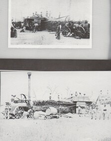
Photograph - HARRY BIGGS COLLECTION: CHAFF CUTTER
Two photographs (proofs 64 and 65) No. 64, A traction Engine driving a chaff cutter?, threshing machine? Via a very long flat belt. Behind the machine is a large pile of hay with several men standing on the heap. To the right of the machine there is another group of men and bags of grain and several bag trucks are visible. Under this photo in very faded writing is: Threshing, Chaff Cutter, Chaff Factory Collingwood, Mrs. J. Collins. 65. A working Traction Engine, cutting or threshing, there are groups of men standing on a pile of hay and also near the machine. A sign on the roof of the machine reads 'Marshalls Gainsborough'topic, farming, threshing, chaff cutter, thresher, chaff factory collingwood, mrs. j collins, marshalls, gainsborough -
 Bendigo Historical Society Inc.
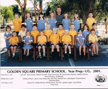
Photograph - GOLDEN SQUARE LAUREL STREET P.S. COLLECTION: PHOTOGRAPH - GSPS YEAR PREP.-1/G 2001
Coloured photograph of the Golden Square Primary School Year Prep.-1/G 2001 class and their teacher. Their names are: Back Row, L to R: Liam Giri, Tayla Leverett, Allanah Croucher Tayla Carmichael, Mr Tong Gundry (Teacher), Helena Lehmann, Emma Hocking, Jai Marshall. Middle Row, L to R: Tanikka Johnson, Jesse Long, Harley Luke, Alex Hunt, Brendan Hurn, Jake Nugent, Rhianna Evans, Shermeka Wood. Front Row, L to R: Jessica Pin, Ashlee Harrison, Brodie Enever, Tom Kirk, Jackson Logan, Laura Winzar, Shaun King.education, primary, golden square laurel st p.s., golden square laurel street p.s. collection - photograph - golden square primary school year prep.-1/g 2001, liam giri, tayla leverett, allanah croucher tayla carmichael, mr tong gundry (teacher), helena lehmann, emma hocking, jai marshall, tanikka johnson, jesse long, harley luke, alex hunt, brendan hurn, jake nugent, rhianna evans, shermeka wood, jessica pin, ashlee harrison, brodie enever, tom kirk, jackson logan, laura winzar, shaun king -
 Kew Historical Society Inc
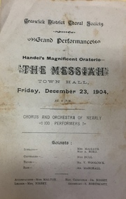
Programme, Creswick District Choral Society, The Messiah, 1904
The Marion Tilley scrapbook is a significant record of performing arts in Melbourne during the 1950s and 1960s. The scrapbook includes programmes, photographs, newspaper reports and personal annotations which are a rich source of detail about repertoire, performers, and artistic sensibility in the period.Souvenir programme issued by the Creswick District Choral Society for a 'Grand Performance of Handel's Magnificent Oratorio The Messiah', in the Town Hall, Friday, December 23, 1904. With a chorus and orchestra of nearly 100 performers, the singers were Sopranos - Mrs. McGrath and Miss A. Horn, Contralto - Miss Bull, Tenor - Mr. V. Woolcock, and Bass - Mr. Marshall. The conductor was Dr. Nisbet. The reverse of the programme includes an advertisement for a Grand Sacred Concert on New Year's Night, Sunday January 1st, 1905 in the Town Hall. The programme was in a scrapbook that includes programmes, photographs and theatre reviews for the Kew Light Opera Company and later "Q" Theatre Guild.creswick district choral society, creswick town hall, the messiah (oratorio) -
 Eltham District Historical Society Inc
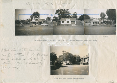
Document - Photograph, Ian McDonald (Shire of Eltham), Main Road, between Arthur Street and Dudley Street, Eltham, 1968-1970
Original document produced by Ian McDonald (Eltham Shire Council) 1970. During the period 1969-1971 photos were being collected for a proposed publication on the history of the Shire of Eltham as part of its centenary celebrations in 1971 (managed by the Shire of Eltham Historical Society and Alan Marshall). The publication was Pioneers & Painters (1971), edited by Alan Marshall. The document titled "Shows area sold to Woolworths" consisted of a panorama of three B&W photo prints creating a panorama of the frontage along Main Road (SEPP_0744) and a single B&W photo print of the Shire of Eltham offices and Hall on the corner of Arthur Street and Main Road (SEPP_0737) along with typed and hand written notes by Ian McDonald. The panorama (SEPP_0744) was captioned in typewritten text "Old Shire Office and Hall, etc - Frontage of 285 feet along Main Road" and in pencil the date "4-1-68" The single image of the shire offices (SEPP_0737) was captioned in typewritten text "Main Road and Arthur Street Corner" In addition, the following handwritten notes in pencil: " I took these photos from the new fire station - the building in the middle is the old fire station - Moved to Research for the Scouts 1970" and signed "IMcD"This photo forms part of a collection of photographs gathered by the Shire of Eltham for their centenary project book,"Pioneers and Painters: 100 years of the Shire of Eltham" by Alan Marshall (1971). The collection of over 500 images is held in partnership between Eltham District Historical Society and Yarra Plenty Regional Library (Eltham Library) and is now formally known as the 'The Shire of Eltham Pioneers Photograph Collection.' It is significant in being the first community sourced collection representing the places and people of the Shire's first one hundred years.Paper with four photos adhered in two groups with notes in typewritten text and handwritten in pencilsepp, shire of eltham pioneers photograph collection, eltham, main road, arthur street, dudley street, barber shop, cinema, commercial bank of australia, eltham fire brigade, eltham hall, eltham shire hall, eltham shire office, fire station, hardware shop, municipal offices, photographer shop, pph, produce paint and hardware centre, shire hall, shire offices, woolworths -
 Eltham District Historical Society Inc
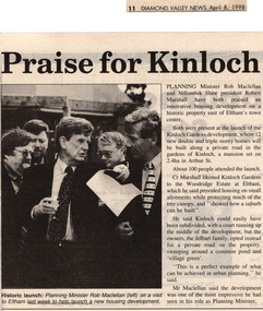
Drawing - Newspaper clipping, Praise for Kinloch, Diamond Valley News, April 8, 1998, p11, April 1998
PLANNING Minister Rob Maclellan and Nillumbik Shire president Robert Marshall have both praised an innovative housing development on a historic property east of Eltham's town centre. Both were present at the launch of the Kinloch Gardens development, where 12 new double and triple storey homes will be built along a private road in the gardens of Kinloch, a mansion set on 2.4ha in Arthur St. About 100 people attended the launch. Cr Marshall likened Kinloch Gardens to the Woodridge Estate at Eltham, which he said provided housing on small allotments while protecting much of the tree canopy, and "showed how a suburb can be built". He said Kinloch could easily have been subdivided, with a court running up the middle of the development, but the owners, the Jelbart family, opted instead for a private road on the property, sweeping around a common pond and 'village green'. ''This is a perfect example of what can be achieved in urban planning,'' he said. Mr Maclellan said the development was one of the most impressive he had seen in his role as Planning Minister Picture - Historic launch: Planning Minister Rob Maclellan (left) on a visit to Eltham last week to help launch a new housing development.Digital file only; created from scan undertaken by EDHS of item on loanarthur street, eltham, graeme gunn, houses, ian jelbart, jelbart property, kinloch gardens, rob maclellan, robert marshall, woodridge estate -
 Whitehorse Historical Society Inc.
Article, Recorded history, 1995
Forest Hill Cricket Club celebrated its 40th anniversary, also the club's history was unveiled in a book 'A History of the Forest Hill Cricket Club'.Forest Hill Cricket Club celebrated its 40th anniversary, also the club's history was unveiled in a book 'A History of the Forest Hill Cricket Club'. Murray Howell with help from others has researched and collated the history.Forest Hill Cricket Club celebrated its 40th anniversary, also the club's history was unveiled in a book 'A History of the Forest Hill Cricket Club'. cricket, forest hill cricket club, howell, murray, mercuri, michael, mccormack, mark, gemma, marshall, bruce, dearing, peter, watson, della -
 Ringwood and District Historical Society
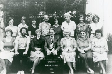
Photograph, Ringwood State School - Staff, 1981
Black and white photograph - Staff, 1981"Attached to photograph" Back Row- L to R: Anne Orchard, Marj Smith, Dawn Colville, Tom Exon, Dianne Jones, John Duffy, Isobel Marshall, Mandy Irvine. Front Row- L to R: Jan Burne (T.C), Stephen Gough, Maureen Gray, Baden Chadwick (Pr), Lindsay Bolden, Pam Wilson, Margaret Beuthan. -
 Queenscliffe Maritime Museum
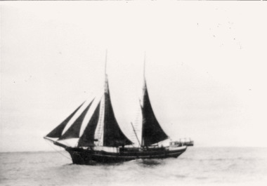
Photograph - B&W Photo of the MILLEETA, Photo of the 2 masted schooner MILLEETA under sail, unknown
the schooner MILLEETA under sailMarconi rigged schooner MILLEETA under sailBlack & white photo of the MILLEETA under sail.Reverse " MILLEETA / schooner, auxiliary, 141 tons gross, 74 tons nett, built Lurang Hammel Warden 1909, Owners MarshallImport & Export Co. Marshall Islands signal letters KNGF 93 ft length BP x 22.1 ft x 9 ft 9 in depth wide Engines GM 6-287A, 500 hp "historical references -
 Eltham District Historical Society Inc
Photograph - Digital Photograph, Alan King, Golden King Mine poppet-head, Yarrambat Primary School, 1 February 2008
The Golden King Mine poppet-head stands at the school’s Yan Yean Road exit gate. Published: Nillumbik Now and Then / Marguerite Marshall 2008; photographs Alan King with Marguerite Marshall.; p23 Early Yarambat - Tanck's Corner Its early settlers, who in the 1840s were amongst the first non-Aboriginal people in the area, found life tough as they grazed their sheep and cattle. Yarrambat was then known as Tanck’s Corner or Reynolds Corner, after wood carter, Frederick Tanck, who owned land north of Ironbark Road, at the corner of Yan Yean Road, and Thomas Reynolds, owner of the opposite property. After Reynolds sold his land, the corner became known as Tanck’s Corner. In 1929 the district’s name was changed to Yarrambat, believed to mean ‘high hill’ in the Wurundjeri language. Tanck’s Corner was in the centre of gold-bearing country and the district is honeycombed with old tunnels and shafts. However although gold played a dominant role for decades, there was insufficient to develop a substantial township. Meat and agricultural produce made a greater impact. Until the mid-20th century the only substantial building was the primary school. The first gold rush occurred around 1860, the second after 1900; then during the Depression, the Government paid men to pan for gold. The first rush attracted hundreds of Chinese people to Smugglers Gully, who constructed round diggings to keep away spirits. Alluvial miners lived along the Plenty River in tents or humpies - some fenced with gardens - and some miners distilled their own ‘plonk’. It was a wild time and bushrangers - and later gangster Squizzy Taylor - were said to hide4 in the old Pioneer Tunnel in Dunne’s Gully between Heard Avenue and Pioneer Road. Mines opposite Tanck’s Corner included Beer’s Line, Golden Crown and Golden Stairs. Some of the big mines had batteries and stampers to process quartz. At first there was plenty of alluvial gold, as much as two ounces to the ton. At times gold was exposed after heavy rains so fossickers panned for gold around orchard irrigation trenches. Gold was mined until 1984 when Yarrambat’s last operating goldmine, the Golden King Mine, in North Oatlands Road, closed. The Clayton family operated it full-time, making a comfortable living and in the 1960s it was the only private family gold mine in Victoria.5 Gold was such an important part of Yarrambat’s history that a gold poppet-head is the Yarrambat Primary School’s logo. The Golden King Mine poppet-head stands at the school’s Yan Yean Road exit gate. However this school was built in 1988. The original school No 2054, at the corner of Ironbark and Yan Yean Roads, was opened in 1878 and modified to its present form in the 1920s. In 2000 it was relocated to the Heritage Museum at Yarrambat Park.7 The school, whose first head teacher was Charles Planner, consisted of one room with a three-roomed residence. The school was also the community centre. On Saturday nights it was crammed for dances or euchre parties, community singing or other social events. On Sundays, services for different denominations took turns each week. However the school had its teething problems. Parents accused Charles Planner of neglecting his duties and the school closed several times. When it closed in 1892, only church services continued. Social activities moved elsewhere, such as the tennis club to the Stuchbery tennis court opposite. A sports day and woodchop on Boxing Day around 1900 was held at the Evelyn Hill Hotel, also called Evelyn Arms and Tunnel Hill Hotel, on the Greensborough–Diamond Creek Road. An annual agricultural show in Diamond Creek paraded through the town, and New Year’s Day picnics at the Yan Yean Reservoir included highland dancing and competitions. Also popular were the Indian hawkers who visited every three months, selling trinkets, clothing and other items. One called Jimmy ‘Allem dem Bedi’, gave presents and told stories, played draughts and sold delicious curries he cooked over his camp fire at night.This collection of almost 130 photos about places and people within the Shire of Nillumbik, an urban and rural municipality in Melbourne's north, contributes to an understanding of the history of the Shire. Published in 2008 immediately prior to the Black Saturday bushfires of February 7, 2009, it documents sites that were impacted, and in some cases destroyed by the fires. It includes photographs taken especially for the publication, creating a unique time capsule representing the Shire in the early 21st century. It remains the most recent comprehenesive publication devoted to the Shire's history connecting local residents to the past. nillumbik now and then (marshall-king) collection, golden king mine, tanck's corner, yarrambat primary school -
 Eltham District Historical Society Inc
Photograph - Digital Photograph, Alan King, Panton Hill Hotel, 27 March 2008
Today’s Panton Hill Hotel was built around 1920. Published: Nillumbik Now and Then / Marguerite Marshall 2008; photographs Alan King with Marguerite Marshall.; p61 Panton Hill was originally known as Kingstown, and consisted of only one hotel when the Orams Reef was discovered in 1859. Kingstown was a quartz mining centre and many old mine shafts remain in the area. Orams Reef was one of the first reefs with a rich find of gold in the area. The Hotel Francais, which had been operating in 1861, was well situated on the way to Queenstown (later St Andrews). So was Herr Hirt’s Hotel and store at Smiths Gully. The Kingstown hotel, known as the Frenchman’s and in 1864 as the Hotel de France, was run by a Monsieur Emile Hude and his wife Jeanne, and known for its good food. They hosted social events, business conventions and debates, attracting patrons from as far as Melbourne. The hotel’s name was changed to Panton Hill Hotel in 1905. In 1883 Charles Caudwell built another hotel nearby, possibly in Long Gully Road,3 which it is thought, was burnt down early last century. Today’s Panton Hill Hotel, built around 1920, is the only one of the cluster of buildings in the main road, not to date from around the turn of last century. It was severely damaged by fire in 2003, then underwent extensive alterations. It is the township’s only hotel and is an example of a modest hotel building exterior, constructed early last century. In its early days the hotel also housed the first post office, newsagency and store. Orams Reef yielded a total of £100,000, and fossikers also found alluvial gold in the creeks and gullies, but there is no record of the total value of their finds. Gold greatly increased the Panton Hill population, which peaked between 1865 and 1885. On holidays large sports meetings were held with wood chopping contests and foot races and the day would end with a ball. Miners came from various countries to seek their fortune, including many from China. The Chinese became unpopular however, and gradually left the district, although some stayed and grew and sold vegetables.5 Panton Hill was named after Joseph Panton, who in 1862 was appointed Police Magistrate for the Woods Point, Heidelberg and Yarra districts. Panton was an outstanding man, who in 1852, was Commissioner of Crown Lands and Assistant Commissioner of Goldfields at Bendigo. In 1874 he was promoted to Chief Magistrate for the Melbourne Police. Panton was also an artist, becoming president of the Victorian Arts Society in 1888, and in 1913, president of the Royal Geographical Society. Despite Panton Hill’s prosperity, it still lacked many services as poor roads made access to Melbourne difficult. A horse-drawn mail coach travelled to Melbourne until 1890, when the railway came to Heidelberg. The nearest doctor was at Yarra Glen or Heidelberg, and the Indian hawker Singh’s annual visit was very welcome. A miner’s shack opposite the school was used as a post office. Today’s general store and post office in the main road dates from early last century, and has changed considerably. While most people searched for gold, the more enterprising ones established farms to feed the diggers. Farmers grew wheat, barley and oats, and sent animal skins to the Eltham tannery, to make furs in Melbourne. As gold became scarce from around 1880, miners took up farming on 19 to 20 acre (8ha) allotments. The first settlers in Cherry Tree Road included Purcell, Smith, Owens, Hughes and Shillinglaw. By 1900 all the land had been taken up around Panton Hill and Hurstbridge. The orchards in Panton Hill and the wider district, particularly of apple and pear, were very successful, and made Panton Hill a cohesive and successful community. About 1914 the Moores built the first cool-store and refrigeration plant at their orchard in Cherry Tree Road. Many settlers planted vineyards and made high quality wine, but in 1922 the blight destroyed them.This collection of almost 130 photos about places and people within the Shire of Nillumbik, an urban and rural municipality in Melbourne's north, contributes to an understanding of the history of the Shire. Published in 2008 immediately prior to the Black Saturday bushfires of February 7, 2009, it documents sites that were impacted, and in some cases destroyed by the fires. It includes photographs taken especially for the publication, creating a unique time capsule representing the Shire in the early 21st century. It remains the most recent comprehenesive publication devoted to the Shire's history connecting local residents to the past. nillumbik now and then (marshall-king) collection, panton hill hotel -
 Eltham District Historical Society Inc
Photograph - Digital Photograph, Alan King, Stonygrad, 34 Hamilton Road, North Warrandyte, 30 January 2008
Vassilieff dynamited rock from his own property to build his house. Stonygrad is reminiscent of a grotto and in parts, of a sculpture. Covered under Heritage Overlay, Nillumbik Planning Scheme. Published: Nillumbik Now and Then / Marguerite Marshall 2008; photographs Alan King with Marguerite Marshall.; p135 Stonygrad, the home built by Expressionist painter and sculptor Danila Vassilieff, is reminiscent of a grotto and in parts, of a sculpture. Vassilieff, who amongst others influenced painter Sydney Nolan and Albert Tucker, was a member of the artists group the Angry Penguins. He was also a highly regarded art teacher at the nearby Koornong Experimental School and taught at Eltham High School. Art critic Robert Hughes described Vassilieff’s painting as ‘lyrical without social commentary’, and said Vassilieff was ‘the most oddly neglected artist in recent Australian History’. Vassilieff, who was born in 1897 in Russia, had an unusually adventurous life before he settled in Warrandyte. The 12th of 18 children, he lived on a farm in the Don Basin. Vassilieff trained with the Imperial Military Academy at St Petersburg and fought in World War One as an officer in the White Russian Army against the communists. In 1920 he was captured, then escaped from prison, stole a horse and rode bareback 150 miles to the Black Sea, helped at first by Tartar freebooters. He then travelled to India, Shanghai and arrived in Queensland as a refugee in 1923 where he began painting. He and his wife Anisia bought a sugar farm near Ingram, and later he constructed railway lines at Mataranka, in the Northern Territory.4 In 1929 Vassilieff went to Brazil for formal art training from former fellow-officer Dmitri Ismailovich, but he soon left to travel up the Amazon River. He then worked as a sidewalk artist in the West Indies and travelled for two years in England, France and Spain. In 1937 he arrived in Melbourne where he lived until his death in 1958. His first major Australian series was the Carlton streetscapes and from 1951 he sculpted in local hard limestone. Vassilieff rejected all dogma and regarded religious subjects as suitable only for decorative arts. In 1944 he helped defeat a communist attempt to take over the Contemporary Art Society. For a short time, from around 1955, Vassilieff taught at various Victorian schools. The Angry Penguins painted mainly between 1937 and 1947, and included Arthur Boyd, Albert Tucker, Sidney Nolan and Joy Hester. The group formed as they felt isolated from European thought and art (including Surrealism) from which their work was derived. They were also angry at what they considered to be the complacency and insularity of their society. They maintained Australians at first were scarcely aware of the threats of the Wall Street Crash and Hitler and were little interested in the Spanish Civil War. The Angry Penguins also objected to the White Australia Policy. Hughes said although most of the Melbourne Expressionists in the 1940s were unskilled and their work crude in style, they helped jolt Australian painting from its pastoral complacency. Their style influenced nearly every painting produced by significant figurative artists in Melbourne in the 1950s such as Charles Blackman. From 1939 Vassilieff built Stonygrad, mainly with local stone. The house stands at the end of a private road surrounded by trees with the quiet occasionally broken by the sounds of bellbirds. To build his house Vassilieff dynamited rock and cut trees from his own property. The original section of the three-level house is of irregular-shaped pieces of solid stone, exposed inside like the exterior. Vassilieff later built sections with timber and brick. Inside is rustic and cave-like, and several rooms are linked by arched openings with no doors. One undulating wall was carved out of rock from which two sculptured heads protrude. Several ceilings are of rough-hewn logs and the built-in table and bookcase are rough, as is a timber ladder leading to a bedroom. Not for the elderly or unsteady! Yet the general impression in the muted light is beautiful, with artistic originality.This collection of almost 130 photos about places and people within the Shire of Nillumbik, an urban and rural municipality in Melbourne's north, contributes to an understanding of the history of the Shire. Published in 2008 immediately prior to the Black Saturday bushfires of February 7, 2009, it documents sites that were impacted, and in some cases destroyed by the fires. It includes photographs taken especially for the publication, creating a unique time capsule representing the Shire in the early 21st century. It remains the most recent comprehenesive publication devoted to the Shire's history connecting local residents to the past. nillumbik now and then (marshall-king) collection, danila vassilieff, hamilton road, north warrandyte, stonygrad -
 Eltham District Historical Society Inc
Photograph - Digital Photograph, Alan King, Southernwood, cnr Bolton and Brougham Street, Eltham, 30 January 2008
Walter Withers once lived at the corner of Bolton and Brougham Streets, Eltham. Covered under Heritage Overlay, Nillumbik Planning Scheme. Published: Nillumbik Now and Then / Marguerite Marshall 2008; photographs Alan King with Marguerite Marshall.; p105 Walter Withers, one of Australia’s most famous artists, once lived in Southernwood, the weatherboard house at the corner of Bolton and Brougham Streets, Eltham. Withers, one of the first prominent artists to live in Eltham, was known for his lyrical paintings of the Australian bush and is associated with the Heidelberg School of artists. Withers was born in 1854 at Handsworth, Warwickshire, England, the grandson of an artist. He studied art at the Royal Academy of Arts, London. But in 1882 his father, opposing an artistic career for Withers, ordered him to go to Australia. However, after working as a jackaroo on several country properties for 18 months, Withers resumed painting in Melbourne, where he enrolled in evening art classes at the Melbourne National Gallery school of painting under G F Folingsby. Employed as a draughtsman by William Inglis & Co, then by Ferguson & Mitchell, lithographic printers, Withers produced portraits in black-and-white for several periodicals. His work was exhibited in the Old Academy, Melbourne. At this time he met and became life-long friends with artists Frederick McCubbin, Tom Roberts and Louis Abrahams. In 1887 Withers went to England and married Fanny Finn. They lived in Paris for awhile, where Withers studied at the Academie Julian. After his return to Melbourne in 1889, Withers lived at the artist camp at Eaglemont, then moved close to the Charterisville mansion, where he established a studio and sub-let cottages to other artists. Around 1892 Withers opened a Collins Street studio, had his first exhibition, and started giving painting classes. One of his pupils was Norman Lindsay, also to become a prominent artist. Withers had long been attracted to Eltham, but had to wait until 1903 to live there, after the railway line was extended to Eltham in 1902. He could then commute to the painting classes he gave in Melbourne. Withers lived on the two and a half acres (1.0ha) Bolton Street property with his wife and five children. They were joined for a short time by prominent painter Sir Hans Heyson who took lessons from Withers. Withers added a studio to the Queen Anne/Edwardian style seven-bedroom home, which had been built in 1891. Each bedroom included a fireplace and most rooms had 12 foot high (3.6m) ceilings. The house retains several fine leadlight windows. Withers painted his largest canvas The Return from the Harvest in 1905, at his Eltham studio. He is represented in national, state and regional galleries, and in many private collections in Australia and abroad. In 1904-05 Withers was president of the Victorian Artists’ Society. Withers at times stayed during the week at his studio in Oxford Chambers, Melbourne, and on weekends and holidays with his family at Eltham. Withers lived in Eltham until his death in 1914, aged 60 years. He had been plagued by rheumatism and in later life by heart and lung disease. It is said he died of a stroke peacefully in a rocking chair in front of the lounge-room fire. He is buried at St Helena in the St Katherine’s Anglican Church cemetery. In 1983, the auction of the house sparked fears that it would be pulled down, or substantially altered. Fortunately the new owners decided to retain the house. Some security was given to the house’s future when it was later included in the Heritage Overlay to the Nillumbik Planning Scheme. The property is also important because it is one of only a few left in the district, which were once owned by noted artists. These include three in Warrandyte: one formerly owned by Penleigh Boyd, another by Frank Crozier, and the other by Danila Vassilieff; and two in Eltham: Percy Leason’s in Lavender Park Road and Justus Jörgensen’s Montsalvat. A small park at the corner of Bible and Arthur Streets, Eltham is named in Walter Withers’ honour.This collection of almost 130 photos about places and people within the Shire of Nillumbik, an urban and rural municipality in Melbourne's north, contributes to an understanding of the history of the Shire. Published in 2008 immediately prior to the Black Saturday bushfires of February 7, 2009, it documents sites that were impacted, and in some cases destroyed by the fires. It includes photographs taken especially for the publication, creating a unique time capsule representing the Shire in the early 21st century. It remains the most recent comprehenesive publication devoted to the Shire's history connecting local residents to the past. nillumbik now and then (marshall-king) collection, bolton steet, brougham steet, eltham, southernwood, walter withers house -
 Eltham District Historical Society Inc
Photograph - Digital Photograph, Alan King, Eltham Primary School No. 209, Dalton Street, Eltham, 28 December 2007
This building is the earliest building remaining on site today. It was built in 1875 and was the second school building replacing the original 1856 building of stone walls with wooden shingles on the roof. That building needed to be replaced after the stone walls collapsed outwards. In August 1912 the school issued a requisition for remodelling of the school concerned with replacement of the existing windows with larger and wider windows to allow additional light into the school rooms and the erection of a wooden partition in the centre of the room. An extension to the building at rear and skylights in the roof were added in 1921. Only two low wooden stairs were originally provided to enter the porch. These were rebuilt by 1928. A steel mud grate was introduced 1930s/1940s and an infant shelter shed circa 1945. Covered under Heritage Overlay, Nillumbik Planning Scheme. Published: Nillumbik Now and Then / Marguerite Marshall 2008; photographs Alan King with Marguerite Marshall.; p49 Eltham Primary School at Dalton Street, bustling with hundreds of students, has changed dramatically since it began in July 1855.1 A reminder of its early days is the building in local sandstone with a slate roof. First head teacher was David G Clark who was officially in charge from June 1856 until 1889.2 This school was not the settlement’s first. That was the Church of England Little Eltham School, west of Diamond Creek in 1853 and closed in 1872. In 1855 David Clark and his sister Catherine, opened what was to become the present school, with eight students. The school operated elsewhere in a temporary slab building, also used for worship by the Wesleyans,3 which allowed the wind and rain easy access. As well as having to endure such Spartan conditions, the students paid one penny a week for the privilege. But in June 1856 the patrons objected to the conditions, and they and the Clarks wrote to the National Schools Board, asking for a suitable school. They asked for a grant to buy land for a school, and to appoint the Clarks. As a result, inspector Mr A B Orlebar visited the school. He found 33 children aged from four to 13 and noted, among other things: ‘There is no attempt at classification, and this is owing chiefly to the want of books, every child bringing with it any spelling or reading book he or she may find at home,4 and partly to the master and mistress having little idea of anything but individual instruction.’ Of Mr Clark, Mr Orlebar said: ‘I cannot pass him as coming up to the full standard of a probationer. He promises however to pursue a course….if the commissioners take him into their service.’ Of Catherine: ‘She makes a promise similar to that of her brother. Pupils were orderly and the school seemed well conducted. I cannot therefore hesitate to recommend them both personally as probationers.’ Later at a public meeting, Mr Orlebar pledged the commissioners would give £150 for a school, if this was matched by local residents. The meeting decided the commissioners would acquire two acres (0.8ha) for the school site. The building, constructed with local sandstone, was completed in December 1857, measuring 40 feet x 16 feet (12mx5m) and 10 feet (3m) high. It was divided into two rooms – one for the school and the other for teacher accommodation. So the Eltham school was born, in an area regarded as ‘one of the poorest in the colony’. Excerpts from inspectors’ reports in the following years, show that in some ways school has not changed that much since then: ‘Discipline only moderate. Too much chattering!’ (1873); ‘Several slates were cleaned with saliva applied by the hand! Damp rags would be much nicer.’(1891).5 In 1863 the Board of Education took over the school giving it its current name and number, Eltham Primary School No 209. Overcrowding has dogged the school over much of its history. In 1875 overcrowding spilled part of the school into the local courthouse. But that year the sandstone building, which is still standing, was built for 100 children, costing £553 and replacing the National School building. Now, this section, even following renovations, still bears part of its original graciousness, with lofty timber ceilings, tall vertical windows and original floors.This collection of almost 130 photos about places and people within the Shire of Nillumbik, an urban and rural municipality in Melbourne's north, contributes to an understanding of the history of the Shire. Published in 2008 immediately prior to the Black Saturday bushfires of February 7, 2009, it documents sites that were impacted, and in some cases destroyed by the fires. It includes photographs taken especially for the publication, creating a unique time capsule representing the Shire in the early 21st century. It remains the most recent comprehenesive publication devoted to the Shire's history connecting local residents to the past. nillumbik now and then (marshall-king) collection, dalton street, eltham primary school, state school no. 209