Showing 2319 items matching "parishes"
-
 Eltham District Historical Society Inc
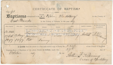
Certificate - Certificate of Baptism, Nancy Josephine Pitt Withers, 27 October, 1897
Born 17 May 1897, daughter of Walter Herbert and Fanny Withers, baptised in the Parish of St John, Heidelberg, Victoria1897, baptism certificate, fanny withers (nee flinn), john withers collection, nancy josephine pitt withers, st john's anglican church heidelberg, walter herbert withers -
 Greensborough Historical Society
Article, The History of Mill Park, 31/07/1838
A short history of the Mill Park area from its initial sale in 1838 as Portions 19 and 20, Parish of Keelbundora.4 p. typescriptmill park -
 Ringwood and District Historical Society
Booklet, Tribute to Kathleen Noela Motumat and the Celebration of her life at Our Lady's Church , Bedford Road, Ringwood 16th. April 1984
Kathleen was a great worker with the Confraternily of Christian Doctrine in the Ringwood Parish and also known by generations of students at Yarra Theological Union.White card covers with an eight page booklet inside detailing the life of Noela. White paper with black printing. -
 Linton and District Historical Society Inc
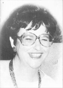
Programme, The Rector's Adventure, Linton Dramatic Club, 1942, 1942
Programme for local Amateur Dramatic club performance in Parish Hall, Linton. Proceeds went to the Red Cross Linton branch.White folded paper, title "The Rector's Adventure . . ." on front, with drawing of the sun with a face. Cast of characters and names of actors inside.Text, front: " PROGRAMME / THE RECTOR'S / ADVENTURE / An entertaining three - / act Comedy produced / by Linton Dramatic Club. " Note handwritten across top inside fold: "During world war 2 about 1942 in aid of Red Cross Linton".linton dramatic club, miss d.smith, clem o'beirne, miss k. nichol, jack collins, miss k. cunningham, h.p. bennett, h. kennedy, l.g. sprake, mr j. megee, miss j. collins -
 Bendigo Historical Society Inc.
Map - CAMPBELL COLLECTION: BENDIGO AND DISTRICT MAPS, 8-7-29
Map. Rifle Range, Parishes of Wellsford and Sandhurst. Scale 20 chains to 1 inch. Total area by Planimeter 5916 acres. Wallan and Bendigo Railway line. Rifle Range. Axedale township and station 8 miles. To Longlea Ryl station 2 1/2 miles. To Epsom 1 1/2 miles. To Bendigo 3 miles. Compiled in W.P.D. from Assessment and Parish Plans by H.A.D 8-7- 29 (number 367 in map cupboard 1)H.A.D.(H.A.Darby)map, bendigo, allotments -
 Bendigo Historical Society Inc.
Document - LANDS OFFICE REGISTER OF CROWN LANDS SOLD SANDHURST, 1855 - 1869
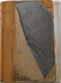
Journal: black hard cover journal with buff spine and corners. Front cover badly damaged Written on spine ' S.I. Sales 1855 - 1869' '05' written in red ink on top of spine. On front cover 'G.W. Groves' written in blue ink under torn cover. Blue lined pages contain details of crown lands surveyed in district of Sandhurst, town, suburban and country. Details of parish, area, date of sale, price and name of purchaser. Indexed by parish on first page.Lands Officeland sales, lands office, land sales, land surveyed, sandhurst, bendigo -
 Bendigo Historical Society Inc.
Document - LANDS OFFICE - CROWN LANDS SURVEYED AND SOLD SANDHURST, 1860 onwards
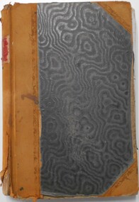
Journal: LANDS OFFICE - CROWN LANDS SURVEYED AND SOLD SANDHURST green hard cover journal with buff spine and corners. Contains details of crown land surveyed and sold in the district of Sandhurst. Indexed in front by parish, alphabetical double pages not numbered. On LH page, parish, town, suburban, country, date of survey. On RH page, date of sale, auction, selection, price, total amount, purchaser. On spine ' index book' 'F' and '09'. Dated from 1860 onwardsLands Officeland sales, bendigo -
 Bendigo Historical Society Inc.
Document - LANDS OFFICE, CROWN LANDS SURVEYED AND SOLD, 1860/70
Document: buff hard cover journal, embossed on borders. On spine 'Lands and Survey' 'Index Book' and '03'. Contains list of parishes in front cover, indexed to page numbers which describes land surveyed and sold in parishes. Double page entries. 230 pages in book. LH page ' town lands, suburban lands, country lands, total lands surveyed, date of survey. RH page: date of sale, by auction, by selection, price per acre, total amount name of purchaser.Lands Officeland sales, lands office, land surveyed, land sold, bendigo, sandhurst -
 City of Moorabbin Historical Society (Operating the Box Cottage Museum)
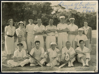
Photograph, Black & White, St Matthew's Church of England Cricket Team c 1940, c1940
The Cheltenham parish was created in 1865 by excising a portion of the parish of St Andrews Brighton. A small brick church was completed in 1867 to serve a rural community stretching from Brighton South (Moorabbin) to Mordialloc. 1867 St Matthew's Church of England was erected in Cheltenham beside the Nepean Highway near Charman Road. The early settlers established a tennis club, cricket team and social groups.St Matthew's Church of England Cheltenham was erected in 1867 and was integral to the spiritual well being and social life of the early settlers.Black & White photograph of the St Matthews Church of England Cricket team Cheltenham c 1940Front ; Church of England Cricket Team 1940 Back ; Written - Ladies / Hilda Biehl, Bertha Schneeberber, Mrs Wootton, / We made afternoon tea from / a kerosene tin for 30 players / each Saturday they played at home !!smith j l; smith mary ann, stanley helen, chaff cutter, horse drawn carts, toll gates brighton, motor cars 1900, steam engines, early settlers, bentleigh, parish of moorabbin, city of moorabbin, county of bourke, moorabbin roads board, shire of moorabbin, henry dendy's special survey 1841, were j.b.; bent thomas, o'shannassy john, king richard, charman s, highett william, ormond francis, maynard dennis, market gardeners, vineyards, orchards, -
 Kiewa Valley Historical Society
Maps - Tawonga and Feathertop
Plan of Tawonga showing roads etc, rivers, use of land in 1968 and of Feathertop in 1969.Historical use of land in Tawonga and Feathertop.1. Topographical Map - Tawonga 803 Forests Commission of Victoria 1968. Cream paper with black print. Legend: Roads, tracks etc, rivers, Parishes and use of land. 2. Feathertop 813. 1969tawonga map 1968, tawonga parishes, feathertop map 1969 -
 Federation University Historical Collection
Plan, Scarsdale County of Grenville, 1889, 26/01/1889
Rectangular plan of a geological survey edged in masking tape. It is predominantly grey, pink and green, but has some yellow. scale is 40 chains to one inch. (see Cat. No. 1098 for report on the Parish of Scarsdale)scarsdale, grenville, krause, browns and scarsdale, mopianimum, watershed, yarrowee, woady yalloak, timber reserve, department of mines, plans, cgt, crown lands, ferdinand krause -
Bendigo Historical Society Inc.
Map - CAMPBELL COLLECTION: BENDIGO & DISTRICT MAPS, 2-2-29
Map. Wellsford, Parishes of Wellsford and Axedale. Scale 20 chains to 1 inch. Total area 4994 acres. Prepared in W.P.B. from A. and P. Plans by W.J.G. (number 377 in map cupboard 1)W.J.Galbraithmap, bendigo, country lands -
Port Melbourne Historical & Preservation Society
Photograph - Garden City Pensioner's Club at Warburton, 16 Oct 1963
.01 - B&W photocopy of Garden City Pensioner's Club at Warburton (16.10.1963). .02 B&W photocopy of Garden City Pensioner's Club outside St Mary's Parish Hall at Warburton (16.10.1963).Gardengarden city, garden city pensioner's club, st mary's warburton -
Port Melbourne Historical & Preservation Society
Photograph - First communion, St Joseph's, Port Melbourne, 1951 - 1952
First communion photo. St Josephs 1951 or 1952. Parish Priest Father Bernard O'FARREL. Taken in school yard corner Bay and Rouse Streets against Swallows ice cream company wall.Some names on backeducation - primary schools, bernard o'farrel, niel king, vin elder, tom moloney, kevin roberts, trevor short, terry little, chris power, roy kent, frank o'connor, john reynolds -
Whitehorse Historical Society Inc.
Newspaper - Newsletter, St John's, Mitcham newsletter, 40th anniversary of the Parish, 1992
5 copies of the Newsletter for St John's, Mitcham Jan, Feb 1992, features 40th anniversary of St John's Parish also manuscript description of Mass for pioneers buried in the Air Hill Burial Ground.st johns catholic church, mitcham, air hill burying ground -
Whitehorse Historical Society Inc.
Pamphlet - Newsletter, The Parish Messenger, 1920-1957
Anglican parish newsletter for Vermont, Bayswater and Wantirna (and Forest Hill from Nov. 1928).Anglican parish newsletter for Vermont, Bayswater and Wantirna (and Forest Hill from Nov. 1928). Monthly. Holdings: No.1 Dec. 1920 - No 210 Jun 1949, No. 235 Dec. 1951 - No. 300 Nov. 1957Anglican parish newsletter for Vermont, Bayswater and Wantirna (and Forest Hill from Nov. 1928).st lukes anglican church vermont, st stephens anglican church bayswater, st johns anglican church wantirna, st marks anglican church forest hill -
 Whitehorse Historical Society Inc.
Photograph, War memorial
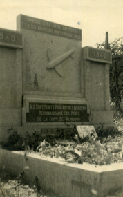
Black & white snapshot of a gravestone in Werhmont cemetery with aeroplane in relief.with inscription - Gravestone in Parish Cemetery of Wehrmont. The graves of most of the crew before re-interment took place after the war (WW2) ended.war memorials -
Southern Sherbrooke Historical Society Inc.
Cash book - Carlotta Tye Memorial Church, 1938-1952
Receipts and expenditure of the Selby Anglican Church (Carlotta Tye Memorial Church) from 1/4/1938 to 31/12/1944, and the Selby Parish Hall from June 1938 to 31/12/1952.carlotta tye, selby parish hall -
 Kew Historical Society Inc
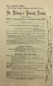
Pamphlet - Document, St Hilary's Anglican Church, St Hilary's Parish Notes, No.70., March 1919, 1919
St Hilary's Anglican Church in Rowland Street, Kew was established in 1888 on land granted to the congregation by the Dumaresq family.The Parish Notes are historically interesting as they outline the various ways in which the Influenza Epidemic of 1919 had an impact on local communities. St Hilary's Church of England Parish Notes from 1919, which includes among other items of interest states that because of the risks of contagion during the influenza epidemic, parishioners are required to worship outside. Written note on front page signed by the Rev Charles H Barnes and dated 16/3/19.st hilary's church of england - kew (vic), churches - kew (vic), influenza epidemic 1919 - kew (vic) -
 Kew Historical Society Inc
Plan - Framed Subdivision Plan (copy), F Price, Plan of Mr William Derrick's Land, Kew being Subdivision of Part of Section 86, Parish of Boroondara, County of Bourke, 1872, 1872
William Derrick was an early landowner in Kew, and with James Venn Morgan and James Dannock the purchaser of the parcel of land bounded by Cotham Road, High Street and Mary Street. Derrick Street in Kew is named after him.Map mounted under perspex. ‘Plan of Mr Willia Derrick's Land, Kew being Subdivision of Part of Section 86, Parish of Boroondara, County of Bourke’. This is a copy of the plan held in the State Library of Victoria.kew subdivision plan, john derrick, subdivision plans -- kew (vic.) -
 Bendigo Historical Society Inc.
Document - PETER ELLIS COLLECTION: DRAFT OF WHIPSTICK SUBMISSION
Appendices to Draft of Whipstick Submission to LCC, Appendix 1. Locations are in the Parishes of Whirrakee, Egerton, Neilborough, Nerring, Huntly and Eaglehawk. Soil types are mentioned and also the Whipstick Scrub area. Type of park is mentioned.bendigo, national parks, peter ellis collection, kamarooka forest, egerton forest, lightning hill recreation reserve, eaglehawk rifle range, new moon mines, d j paton, bendigo field naturalists club, land conservation council, eucalyptus oil production -
 Ringwood and District Historical Society
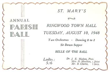
Memorabilia, Ticket for St Mary's Annual Parish Ball, Ringwood, Victoria - 1948, 10-Aug-48
Ticket for St Mary's Annual Parish Ball - Two orchestras, dancing 8-2, sit down supper and Belle of the Ball.Buff coloured card with green printing and deckled edge. Ringwood Town Hall. Tuesday, August 10, 1948. Two orhestras - Dancing 8 to 2. Sit Down Supper. Belle of the Ball. Ladies: 5/6 Dr. J.E. Mahon, Pres. Mrs. N. Madden, Mr. B. Clarke, Joint Secs. -
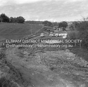 Eltham District Historical Society Inc
Negative - Photograph, J.A. McDonald, Hurstbridge-Arthurs Creek Road, Aug. 1960
Culvert at Patullo’s CA 34H1 Sec. B, Parish of Greensborough F. Wood Drott and truck Council crane August 1960Record of various Shire of Eltham infrastructure works undertaken during the period of 1952-1962 involving bridge and road reconstruction projects, sometimes with Eltham Shire Council Project Reference numbers quoted. It was during this period that a number of significant improvements were made to roads and new bridges constructed within the shire that remain in place as of present day (2022). In many situations, the photos provide a tangible visible record of infrastructure that existed throughout the early days of the Shire. The album was put together by or under the direction of the Shire Engineer, J.A. McDonald.infrastructure, shire of eltham, 1960-08, hurstbridge-arthurs creek road, bridge construction, bulldozer, cranes, drott, road construction -
Glen Eira Historical Society
Document - St Mary The Virgin, Kooyong Road, South Caulfield
Parish of St Mary the Virgin, Flyer, calendar of church services and meeting from 24/02/1998 to 22/03/1998.st mary the virgin -
 Eltham District Historical Society Inc
Certificate - Certificate of Baptism, Nancy Josephine Pitt Withers, 27 October, 1902
Born 5 February 1902, son of Walter Herbert and Fanny Withers of Heidelberg, baptised in the Parish of St John, Heidelberg, Victoriabaptism certificate, fanny withers (nee flinn), john withers collection, walter herbert withers, 1902, charles meynell pitt withers, st john's anglican church heidelberg -
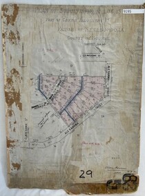 Greensborough Historical Society
Poster - Planning Document, City of Heidelberg, Subdivision Plan # G 29 Part 1, Crown allotment 17, Greensborough, 1922
Plan of Subdivisions in City of Heidelberg: Parish of Keelbundoora: Crown allotment 17 - Warwick Road, Clydbank Street, Alexandra Street, 1922.An example of hard copy subdivision plans from the Greensborough area. Mainly from the Shire of Diamond Valley era (1964-1994).Plan (single sided) mounted on heavy card. Stamped and handwritten Council permissions, dates and other details.subdivision plans, city of heidelberg -
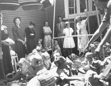 Ringwood and District Historical Society
Photograph, 1950 - Parish Hall Xmas Party, Church of England, Ringwood Street, Ringwood. Attendees included Mrs. J. Mason (partly obscured), Mrs. Gray, Mrs. McCrae Snr., Mr. and Mrs. G. Williams
Typed below photograph, "1950 - Parish Hall Xmas Party. Just seen Mrs. J. Mason, Mrs. Gray, Mrs. McCrae Snr., Mr. and Mrs. G. Williams". -
 Linton and District Historical Society Inc
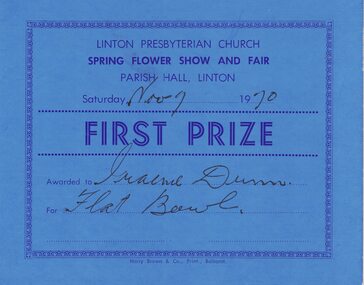
Certificate, Harry Brown & Co. Print., Ballarat, Linton Presbyterian Church Spring Flower Show, First Prize, 1970, 1970
Awarded to Graeme Dunn.Rectangular, blue cardboard certificate for first prize at Linton Presbyterian Church Spring flower show and fair, 1970.Text: " LINTON PRESBYTERIAN CHURCH / SPRING FLOWER SHOW AND FAIR / PARISH HALL, LINTON / Saturday Nov 7 1970 / FIRST PRIZE / Awarded to Graeme Dunn / For Flat Bowl.linton presbyterian church, events, flower shows, certificates, awards, graeme dunn -
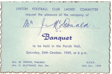 Linton and District Historical Society Inc
Invitation, Linton Football Club Ladies' Committee Banquet, 1959, 1959
Blue card, gold edging, dark blue writing. Invitation to Mr. J. McDonald to attend the Linton Football Club Ladies Committee banquet, held on 24th October 1959.Text: " LINTON FOOTBALL CLUB LADIES' COMMITTEE / request the pleasure of the company of Mr. J. McDonald / at a / Banquet / to be held in the Parish Hall, / Saturday, 24th October, 1959, at 6 p.m. "linton football club ladies' committee, mr j. mcdonald, mrs w. ringin, mrs g. mcdonald, events, invitations, tickets -
Stawell Historical Society Inc
Map, Borough of Stawell Parish of Stawell and Illawarra 10/06/1903, 10/06/1903
Department of Lands and Survey Map of Stawell with marked roads, allotments, physical landmarks. Found in Storage at ANZ Bank when the old archive was being cleaned out. Also shows Surveyed but unused roads. Showed where customers lived in StawellPholtolithograph Map - Paper on canvas backingBorough of Stawell. Parish of Stawell and Illawarra. County of Borong. Scale 8 Chains to 1 Inch. Scale 16 Chains to 1 Inch. Red Ink Writing, Purple and Blue.town