Showing 11129 items
matching planning
-
 The Beechworth Burke Museum Research Collection
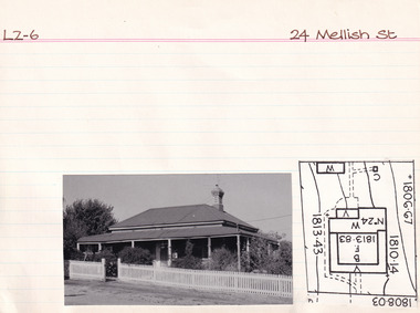
Card (Series) - Index Card, George Tibbits, 24 Mellish Street, Beechworth, 1976
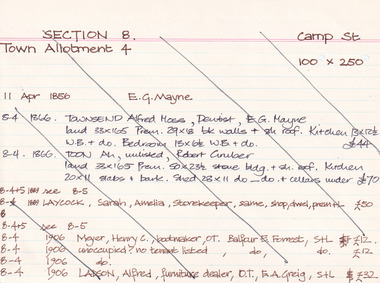
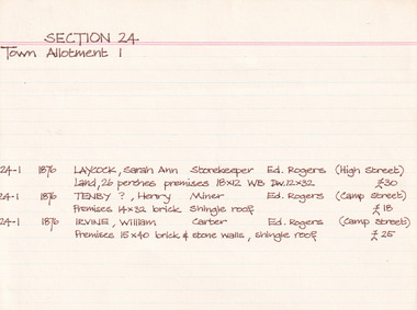
... Planning, University of Melbourne, Parkvill, Victoria, Australia ...George Tibbits, University of Melbourne. Faculty of Architecture, Building and Town & Regional PlanningIndex system that support the research for Beechworth : historical reconstruction / [by] George Tibbits ... [et al]Arranged by street names of BeechworthEach index card includes: street name and number of property, image of property, allotment and section number, property owners and dates of ownership, description of the property according to rate records, property floor plan with dimensions.beechworth, george tibbitsbeechworth, george tibbits -
 The Beechworth Burke Museum Research Collection
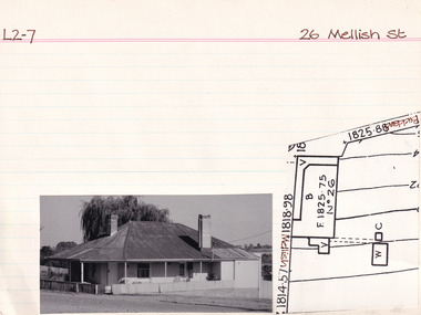
Card (Series) - Index Card, George Tibbits, 26 Mellish Street, Beechworth, 1976
... Planning, University of Melbourne, Parkvill, Victoria, Australia ...George Tibbits, University of Melbourne. Faculty of Architecture, Building and Town & Regional PlanningIndex system that support the research for Beechworth : historical reconstruction / [by] George Tibbits ... [et al]Arranged by street names of BeechworthEach index card includes: street name and number of property, image of property, allotment and section number, property owners and dates of ownership, description of the property according to rate records, property floor plan with dimensions.beechworth, george tibbitsbeechworth, george tibbits -
 The Beechworth Burke Museum Research Collection
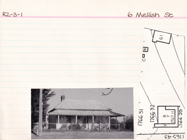
Card (Series) - Index Card, George Tibbits, 6 Mellish Street, Beechworth, 1976
... Planning, University of Melbourne, Parkvill, Victoria, Australia ...George Tibbits, University of Melbourne. Faculty of Architecture, Building and Town & Regional PlanningIndex system that support the research for Beechworth : historical reconstruction / [by] George Tibbits ... [et al]Arranged by street names of BeechworthEach index card includes: street name and number of property, image of property, allotment and section number, property owners and dates of ownership, description of the property according to rate records, property floor plan with dimensions.beechworth, george tibbitsbeechworth, george tibbits -
 The Beechworth Burke Museum Research Collection
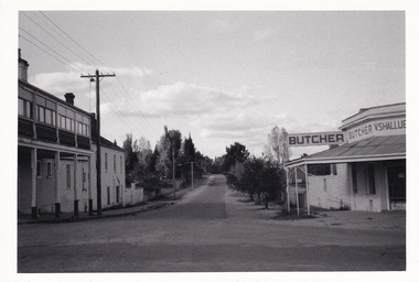
Photograph (Series) - Index Card, George Tibbits, High St, Beechworth, 1976
... Planning, University of Melbourne, Parkvill, Victoria, Australia ...George Tibbits, University of Melbourne. Faculty of Architecture, Building and Town & Regional PlanningIndex system that support the research for Beechworth : historical reconstruction / [by] George Tibbits ... [et al]Arranged by street names of BeechworthEach index card includes: street name and number of property, image of property, allotment and section number, property owners and dates of ownership, description of the property according to rate records, property floor plan with dimensions.beechworth, george tibbitsbeechworth, george tibbits -
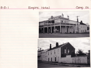
 The Beechworth Burke Museum Research Collection
Photograph (Series) - Index Card, George Tibbits, Camp Street, Beechworth, 1976
... Planning, University of Melbourne, Parkvill, Victoria, Australia ...George Tibbits, University of Melbourne. Faculty of Architecture, Building and Town & Regional PlanningIndex system that support the research for Beechworth : historical reconstruction / [by] George Tibbits ... [et al]Arranged by street names of BeechworthEach index card includes: street name and number of property, image of property, allotment and section number, property owners and dates of ownership, description of the property according to rate records, property floor plan with dimensions.beechworth, george tibbitsbeechworth, george tibbits -
 The Beechworth Burke Museum Research Collection
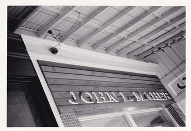
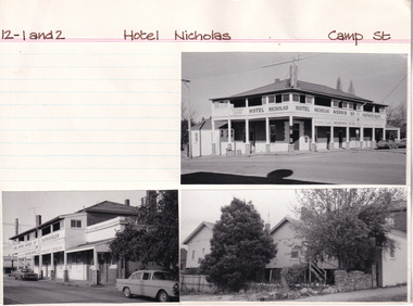
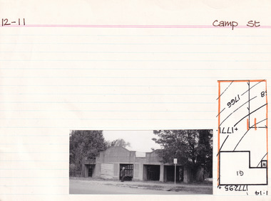
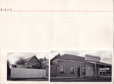
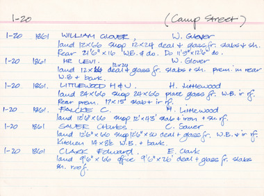
Card (Series) - Index Card, George Tibbits, Camp Street, Beechworth, 1976
... Planning, University of Melbourne, Parkvill, Victoria, Australia ...George Tibbits, University of Melbourne. Faculty of Architecture, Building and Town & Regional PlanningIndex system that support the research for Beechworth : historical reconstruction / [by] George Tibbits ... [et al]Arranged by street names of BeechworthEach index card includes: street name and number of property, image of property, allotment and section number, property owners and dates of ownership, description of the property according to rate records, property floor plan with dimensions.beechworth, george tibbitsbeechworth, george tibbits -
 The Beechworth Burke Museum Research Collection
Card (Series) - Index Card, George Tibbits, Camp Street, Beechworth, 1976
... Planning, University of Melbourne, Parkvill, Victoria, Australia ...George Tibbits, University of Melbourne. Faculty of Architecture, Building and Town & Regional PlanningIndex system that support the research for Beechworth : historical reconstruction / [by] George Tibbits ... [et al]Arranged by street names of BeechworthEach index card includes: street name and number of property, image of property, allotment and section number, property owners and dates of ownership, description of the property according to rate records, property floor plan with dimensions.beechworth, george tibbitsbeechworth, george tibbits -
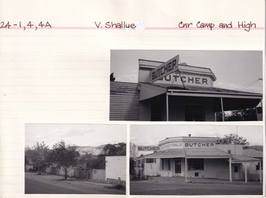
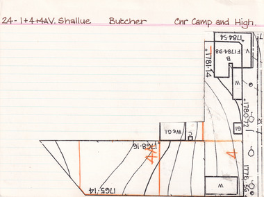
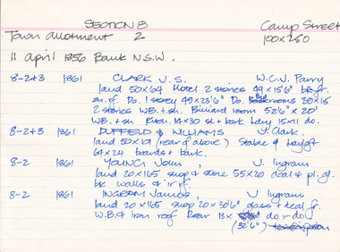
 The Beechworth Burke Museum Research Collection
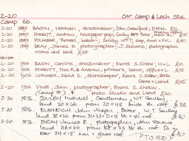
Card (Series) - Index Card, George Tibbits, Camp Street (Cnr Camp & High Streets), Beechworth, 1976
... Planning, University of Melbourne, Parkvill, Victoria, Australia ...George Tibbits, University of Melbourne. Faculty of Architecture, Building and Town & Regional PlanningIndex system that support the research for Beechworth : historical reconstruction / [by] George Tibbits ... [et al]Arranged by street names of BeechworthEach index card includes: street name and number of property, image of property, allotment and section number, property owners and dates of ownership, description of the property according to rate records, property floor plan with dimensions.beechworth, george tibbitsbeechworth, george tibbits -
 The Beechworth Burke Museum Research Collection
Card (Series) - Index Card, George Tibbits, Cap Street, Beechworth, 1976
... Planning, University of Melbourne, Parkvill, Victoria, Australia ...George Tibbits, University of Melbourne. Faculty of Architecture, Building and Town & Regional PlanningIndex system that support the research for Beechworth : historical reconstruction / [by] George Tibbits ... [et al]Arranged by street names of BeechworthEach index card includes: street name and number of property, image of property, allotment and section number, property owners and dates of ownership, description of the property according to rate records, property floor plan with dimensions.beechworth, george tibbitsbeechworth, george tibbits -
 The Beechworth Burke Museum Research Collection
Card (Series) - Index Card, George Tibbits, Camp Street, Beechworth, 1976
... Planning, University of Melbourne, Parkvill, Victoria, Australia ...George Tibbits, University of Melbourne. Faculty of Architecture, Building and Town & Regional PlanningIndex system that support the research for Beechworth : historical reconstruction / [by] George Tibbits ... [et al]Arranged by street names of BeechworthEach index card includes: street name and number of property, image of property, allotment and section number, property owners and dates of ownership, description of the property according to rate records, property floor plan with dimensions.beechworth, george tibbitsbeechworth, george tibbits -
 The Beechworth Burke Museum Research Collection
Card (Series) - Index Card, George Tibbits, High Street, Beechworth, 1976
... Planning, University of Melbourne, Parkvill, Victoria, Australia ...George Tibbits, University of Melbourne. Faculty of Architecture, Building and Town & Regional PlanningIndex system that support the research for Beechworth : historical reconstruction / [by] George Tibbits ... [et al]Arranged by street names of BeechworthEach index card includes: street name and number of property, image of property, allotment and section number, property owners and dates of ownership, description of the property according to rate records, property floor plan with dimensions.beechworth, george tibbitsbeechworth, george tibbits -
 The Beechworth Burke Museum Research Collection
Card (Series) - Index Card, George Tibbits, Corner of Camp and High Streets, Beechworth, 1976
... Planning, University of Melbourne, Parkvill, Victoria, Australia ...George Tibbits, University of Melbourne. Faculty of Architecture, Building and Town & Regional PlanningIndex system that support the research for Beechworth : historical reconstruction / [by] George Tibbits ... [et al]Arranged by street names of BeechworthEach index card includes: street name and number of property, image of property, allotment and section number, property owners and dates of ownership, description of the property according to rate records, property floor plan with dimensions.beechworth, george tibbitsbeechworth, george tibbits -
 The Beechworth Burke Museum Research Collection
Card (Series) - Index Card, George Tibbits, Camp Street, Beechworth, 1976
... Planning, University of Melbourne, Parkvill, Victoria, Australia ...George Tibbits, University of Melbourne. Faculty of Architecture, Building and Town & Regional PlanningIndex system that support the research for Beechworth : historical reconstruction / [by] George Tibbits ... [et al]Arranged by street names of BeechworthEach index card includes: street name and number of property, image of property, allotment and section number, property owners and dates of ownership, description of the property according to rate records, property floor plan with dimensions.beechworth, george tibbitsbeechworth, george tibbits -
 The Beechworth Burke Museum Research Collection
Card (Series) - Index Card, George Tibbits, Camp Street, Beechworth, 1976
... Planning, University of Melbourne, Parkvill, Victoria, Australia ...George Tibbits, University of Melbourne. Faculty of Architecture, Building and Town & Regional PlanningIndex system that support the research for Beechworth : historical reconstruction / [by] George Tibbits ... [et al]Arranged by street names of BeechworthEach index card includes: street name and number of property, image of property, allotment and section number, property owners and dates of ownership, description of the property according to rate records, property floor plan with dimensions.beechworth, george tibbitsbeechworth, george tibbits -
 Ringwood and District Historical Society
Newspaper, Scrapbook Clipping, Library Collection, Ringwood, Victoria
Newspaper Clipping from "The Mail", 17-12-96, Page 5 . 'Sports plan is rejected' - By Jamie DuncanMaroondah Council has knocked back Yarra Valley Anglican School's plans to build an indoor sports complex on its Kalinda Rd site. Nearby residents were concerned abou the potential noise and visual impact of the stadium. -
 Kew Historical Society Inc
Plan - Saxonwood Estate, Doncaster [East]
Subdivision plans and real estate flyers/brochures reveal a number of aspects of urban development and history. The Kew Historical Society's collection of these plans, as well as advertisements extracted from magazines, cover key aspects of community development and architectural history of Kew and Kew Eat as well as surrounding suburbs. While most of the plans in the collection were gifted to the Society by the former City of Kew, a number of other plans and advertisements have been donated by individuals, of which this is an example.Undated, multi-page subdivision plan advertising lots for sale bounded by Blackburn Road, George Street, Windermere Avenue, and Saxonwood Drive in what is currently Doncaster East. Other streets in the subdivision include: Mowbray Court, Stafford Court, Rugby Court, and Robin Hood Court. The front page includes a Birdseye view of the estate which identifies existing and projected civic amenities, as well as the estate's relationship to surrounding suburbs and the city centre. Red crosses on the detailed plan of lots on page two indicate those that have been sold. The final page includes a locality plan. saxonwood estate -- doncaster east (vic.), subdivision plans -- doncaster east (vic.) -
Whitehorse Historical Society Inc.
Document, House plan, 1923
Plan of residence for S. Till, located at Clive Street Mitcham.Plan of residence for S. Till, located at Clive Street Mitcham, by A. Kennedy, approved by Shire of Nunawading 27 January 1923Plan of residence for S. Till, located at Clive Street Mitcham.till, sydney norman, shire of nunawading, clive street mitcham, plans -
 Ringwood and District Historical Society
Document - Subdivision Map, Part of Crown Portion 22 Parish of Ringwood, County of Mornington. Vol 1915 Fol 827 - LP2427
LANDATA Land Victoria 4-sheet plan dated January 2003 - copy of original 1889 subdivision, amended with 1947 amendments by Assistant Registrar of Titles.Sheet 1 includes Main Lilydale Road (later Old Lilydale Road), Wandin Road (later Mount Dandenong Road), and Joseph Street, Ringwood East. Additional Plan markings SP30844, SP32804, LP144251, PS332061, PS305232. Sheet 2 includes Main Lilydale Road (later Old Lilydale Road), Wandin Road (later Mount Dandenong Road), and Dynes Street, Ringwood East. Additional Plan markings LP43708, LP44231, LP124702. Sheet 3 includes Main Lilydale Road (later Old Lilydale Road), Dynes Street, Albert Street (later Wyrunga Street), and Carcoola Road, Ringwood East. Additional Plan markings LP114181, LP114180, LP18261, LP214030, LP67300, PS354509, PS335500. Sheet 4 includes Main Lilydale Road (later Old Lilydale Road), Albert Street (later Wyrunga Street), and Carcoola Road, Ringwood East. Additional Plan markings PS315494, PS319495. -
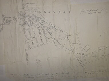 Federation University Historical Collection
Plan, Ballarat Railway Plan, 1860, 29/05/1860
This plan was created by the Railway Department, Victoria.Photocopy of the Melbourne to Ballarat via Geelong Railway plan. The section is the area adjoining Bakery Hill, Ballarat. The plan shows the Yarrowee River, central Ballarat, Government Camp, Imperial Hotel, Union Hotel, Crown hotel, electric Telegraph line, Eureka Lead, Black Hill Lead, Ballaarat Old Cemetery., Bank of Australasia.ballarat railway, ballarat -
Kew Historical Society Inc
Archive (series) - Subject File, Victoria Park : Concept Management Plan, Research Papers, 2004, 2004
Graeme Butler & AssociatesProject FilesProvenance OrderRed cardboard wallet containing historical research by Graeme Butler, heritage architect, into the history of Victoria Park, Kew. The file also includes a draft Victoria Park Concept Master Plan, 2004. The research includes memoranda, maps, photocopies of plans, forms, notes, aerial photos, and sundry references.graeme butler - heritage architect, victoria park - kew (vic), heritage studies - kew (vic.)graeme butler - heritage architect, victoria park - kew (vic), heritage studies - kew (vic.) -
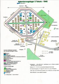 Tatura Irrigation & Wartime Camps Museum
Drawing, Internment Camp 3 Tatura as in 1945, January 1992
Plan of Camp 3 Tatura layout as in 1945. Camp contained members of Palestine, Singapore/Straits Settlement & New Guinea Groups.Laminated coloured A4 plan showing layout of buildings and perimeter fencing of camp 3 Tatura. palestine group, singapore group, new guinea group, camp 3 layout -
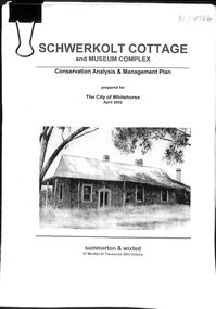 Whitehorse Historical Society Inc.
Book - Schwerkolt Cottage and Museum Complex, April 2002
A Conservation Analysis & Management Plan prepared for the City of Whitehorse. April ,2002Conservation Analysis & Management Plan of Schwerkolt Cottage & Museum ComplexA4, 97p bulldog clipped Conservation Analysis & Management Plan prepared for the City of Whitehorse by Summerton & Wixted . April 2002schwerkolt cottage & museum complex, historic buildings -
 Kew Historical Society Inc
Plan, Melbourne & Metropolitan Board of Works : Borough of Kew : Detail Plan No.1581, 1904
The Melbourne and Metropolitan Board of Works (MMBW) plans were produced from the 1890s to the 1950s. They were crucial to the design and development of Melbourne's sewerage and drainage system. The plans, at a scale of 40 feet to 1 inch (1:480), provide a detailed historical record of Melbourne streetscapes and environmental features. Each plan covers one or two street blocks (roughly six streets), showing details of buildings, including garden layouts and ownership boundaries, and features such as laneways, drains, bridges, parks, municipal boundaries and other prominent landmarks as they existed at the time each plan was produced. (Source: State Library of Victoria)This plan forms part of a large group of MMBW plans and maps that was donated to the Society by the Mr Poulter, City Engineer of the City of Kew in 1989. Within this collection, thirty-five hand-coloured plans, backed with linen, are of statewide significance as they include annotations that provide details of construction materials used in buildings in the first decade of the 20th century as well as additional information about land ownership and usage. The copies in the Public Record Office Victoria and the State Library of Victoria are monochrome versions which do not denote building materials so that the maps in this collection are invaluable and unique tools for researchers and heritage consultants. A number of the plans are not held in the collection of the State Library of Victoria so they have the additional attribute of rarity.Original survey plan, issued by the MMBW to a contractor with responsibility for constructing sewers in the area identified on the plan within the Borough of Kew. The plan was at some stage hand-coloured, possibly by the contractor, but more likely by officers working in the Engineering Department of the Borough and later Town, then City of Kew. The hand-coloured sections of buildings on the plan were used to denote masonry or brick constructions (pink), weatherboard constructions (yellow), and public buildings (grey). The streets and built structures in this plan were surveyed in 1903 and released to contractors in 1904. In addition to the designation of building types by colour, the plan includes detailed descriptions of land use and ownership. While many buildings remain from this period, a number of the buildings represented have been demolished including the original Kew Town Hall, and the Congregational and Roman Catholic churches in Walpole Street. While the mansion ‘Illapa’ in Princess Street is still extant – now part of ‘Rylands’ – the neighbouring mansion ‘Elsmere’ was demolished some decades ago. Rivalling Illapa and Elsmere in size were two mansions in Walpole Street, one named on the plan as ‘Gnarlbine’. Over time, Kew Junction and the south side of High Street have been reconfigured and widened, so that the commercial buildings on the corner of Princess and High Street no longer exist. A surprising feature of this part of central Kew to the northwest of Kew Junction is the amount of vacant land. In a number of cases, this land is noted by the contractor as used for vegetable gardens.melbourne and metropolitan board of works, detail plans, maps - borough of kew, mmbw 1581, cartography -
Glenelg Shire Council Cultural Collection
Administrative record - Plans, Glenelg Shire Council Plan 2009 - 2013, n.d
... planning ...Glenelg Shire Council Plan 2009-2013. Full colour booklet. Matt, full-coloured card covers, shiny full colour pages. front cover: Cape Nelson Lighthouse, shire logo. Back cover: Shire logo, contacts.Front: 'Embracing the Future 2009-2013' Printed in whiteglenelg shire, administrative record, local government, planning, strategy -
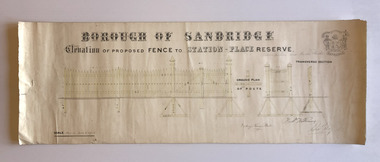 Port Melbourne Historical & Preservation Society
Plan, Charles Clay, Borough Surveyor, Elevation of Proposed Fence to Station Place Reserve, c. 1881
Although undated, the plan is probably from 1880-81. The plan is signed by Charles CLAY, Fred WILLIAMS and Witney Henry BATES. Charles CLAY was the Borough Surveyor from 1860 to 1884. Fred WILLIAMS was a Councillor 1875 to 1886 and served as Mayor, 1880-81. It is not known who Witney Henry BATES was. A note in pencil, probably added later, indicates the fence was between Graham and Bridge Streets.Undated Borough of Sandridge hand-drawn plan for a proposed picket fence at Station Place Reserve.'between Graham and Bridge Streets' handwritten in pencil below and to the right of the main title.local government - borough of sandridge, engineering - fences, charles clay, witney henry bates, frederick williams -
 Surrey Hills Historical Society Collection
Book, Medlow Garden Survey and Landscape capability study 1983, Oct-83
Includes: Plan of Subdivision, Detailed plan, map of garden, Auctioneer's plan for 1854 sale, Botanical plan of Medlow & Landscape history notes. Full title : Medlow Garden survey and landscape capability survey. A report for the National Trust of Australia (Victoria) A report giving a detailed landscape survey of Medlow Garden estate. Includes landscape story, cultural significance, particulars about vegetarian, garden, rehabilitation and plans.Copy of a report giving a detailed landscape survey of Medlow Garden estate. Includes landscape story, cultural significance, particulars about vegetarian, garden, rehabilitation and plans. 38 pages with illustrations.land surveys, medlow garden, bismark estate, rosalie estate, warrigal road, surrey hills, bismarck avenue, warwick avenue, t p payne, (mr) hugh glass, boroondara, (mr) (maj) - cairncross, (mrs) mary jane cairncross, (dr) (mr) richard joseph bull, (mrs) catherine grace bull, (miss) norma bull, (mr) ronald richard bull, medlow -
 Melbourne Tram Museum
Document - Report, Melbourne & Metropolitan Tramways Board (MMTB), "Tramcar location sheet - Preston Workshops"
... planning ...Enabled a report or diagram showing where each tramcar was located at the date within Preston Workshops. This would have enabled workshop planning and tramcar movements. Yields information about the form that would have provided daily information to workshop staff regarding tramcar locations and progress of work.Foolscap duplicated sheet providing a blank form for "Tramcar location sheet - Preston Workshops" - form R438tramcars, tramways, mmtb, preston workshops, planning -
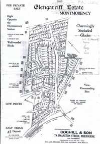 Greensborough Historical Society
Plan, Coghill and Son, Glengarriff Estate Montmorency, 1938c
Plan for the Glengarriff Estate covers 171 lots in vicinity of Montmorency Railway Station, for private sale, controlling agents Coghill & Son, Local Agents Shallard Bros, Main Road Eltham. C/T 6068/1213512 formerly owned by George Nicholson, dentist.Black and white photocopy of a real estate agent's plan of subdivision montmorency, glengarriff estate montmorency, calrossie street montmorency