Showing 3226 items
matching road maps
-
 Warrnambool RSL Sub Branch
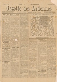
GAZETTE DES ARDENNES, 5 MAY 1918. 4th year, No 621, German newspaper, in French, for the occupied territories, printed in Charleroi, Belgium. (TRANSLATED IN PART by W.Barber), 5 May 1918
Original, single page propaganda broadsheet, collected by Bob Snape, when he was working as Confidential Clerk to General Sir John Monash, with Australia Corps HQ, in Belgium, late 1918. Yellowed with age, but despite some tears along the folds and a hole the size of a 20 cent piece, it is a good legible document with a front-line mapsnape collection -
 Warrnambool RSL Sub Branch
TRENCH MAP, 1:20,000 FRANCE. Sheet 36 NW. Edition 6 B. GSGS 2742. Ordnance Survey 1916. Trenches corrected to 5/5/1916
... Warrnambool great-ocean-road Snape Collection TRENCH MAP, 1:20,000 ...snape collection -
 Warrnambool RSL Sub Branch
Service Jacket; Army Nurses Uniform, Early 1940's
This uniform was worn by Sister Winifred Ride during World War 2.. Nurses played a key role in the conflict through their care and compassion to the servicemen who were wounded and sick.The nurses uniform is symbolic of the sacrifice and service of the many women who served their country in WW2. Grey fitted, lined jacket with long sleeves, collar and lapels. Three front metal buttons buttons and two smaller buttons on each sleeve. Dark green epaulette with four metal buttons on each shoulder (Right side is faded). Two hip pockets with one button fastener. One internal pocket with small grey button. Unit patches on each sleeve and four inverted service chevrons on right sleeve at wrist. Two ribbon bars containing 5 Campaign Ribbons on left side of front, attached with standard 'brooch' fitting . Belt (same material as jacket) passes through two loops on back of jacket and is fastened by two buttons, hidden when belt is fastened. Metal buttons stamped with map of Australia with crown above and the words Australian Military Forces around. Makers label inside back below collar: " /tailors and habit makers, J .RAVENSDALE & SON Nicholas Bldg Swanston Street Melbourne". Name of owner handwritten "Sister Ride:" -
 Warrnambool RSL Sub Branch
Book, THE COST OF COURAGE
Paperback. Title superimposed on coloured map of VietnamAuthor Carla Evans Published 2012 -
 Warrnambool RSL Sub Branch
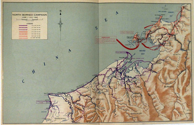
Map, NORTH BORNEO CAMPAIGN. June-July 1945
... Warrnambool great-ocean-road Map WW2. North Borneo Different coloured ...Paper. Colour. Different coloured arrows show troop movements in Brunei and Labuan Islandmap ww2. north borneo -
 Warrnambool RSL Sub Branch
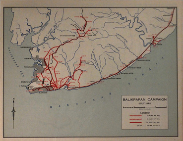
Map, BALIKPAPAN CAMPAIGN. July 1945
... Warrnambool great-ocean-road Map. Balikpapan Legend shows troop ...Paper. Basic colourLegend shows troop movements during the Campaignmap. balikpapan -
 Warrnambool RSL Sub Branch
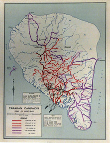
Map, TARAKAN CAMPAIGN. 1st May-21st June 1945
Paper, Basic colourLegend shows troop movements during the Campaign on Tarakan Island. -
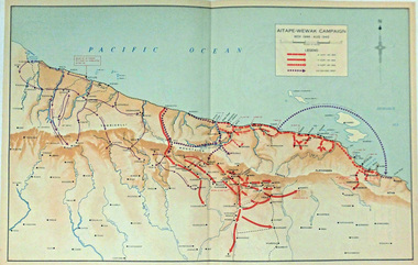 Warrnambool RSL Sub Branch
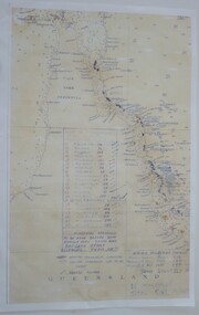
Map, AITAPE-WEWAK CAMPAIGN. Nov 1944-Aug 1945
Paper, basic coloursLegend shows troop movements during the Campaignww2 aitape-wewak -
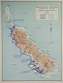 Warrnambool RSL Sub Branch
Map, BOUGAINVILLE CAMPAIGN. Nov 1944-June 1945
Paper, Basic coloursLegend shows troop movements during the Campaign -
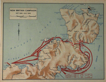 Warrnambool RSL Sub Branch
Map, NEW BRITAIN CAMPAIGN. October 1944-July 1945
Paper. Basic coloursLegend shows troop movements during the Campaign -
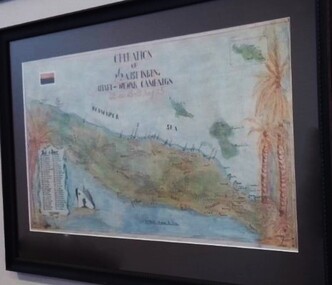 Warrnambool RSL Sub Branch
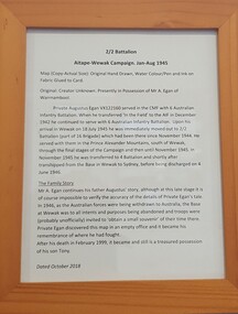
Photograph - Aitape Wewak Campaign Map WW2, Aitape Wewak Campaign. 2/2 Battalion Jan-Aug 1945
Photographic copy of original which is in private handsStory of 2/2 Battalion in NG in 1945 and its history with present owners -
 Warrnambool RSL Sub Branch
Work on paper - 2/2 Battalion Aitape Wewak Campaign, 2/2 Battalion Aitape Wewak Campaign Jan-Aug 1945
Framed print-out of the adjacent map's storyDetails the story of the 2/2 Battalion in the Aitape Wewak campaign, and the story of its connection with the present owners -
 Warrnambool RSL Sub Branch
Map - 1947 Minesweeping map, North Queensland minesweeping map, unknown
1947 an after-effect od WW2Laminated A3 Map plus A4 map in pocket (copies of original)shows location of minefields to be cleared in 1947 and names of minesweeping ships!947 ran history -
 Warrnambool and District Historical Society Inc.
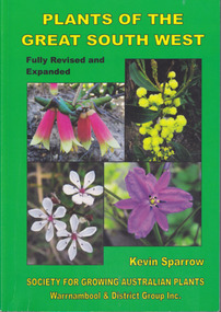
Book, Star Printing Terang Victoria. 978-0-9751360-1-0, Plants of the Great South West 2013 Second Edition, 2013
Second edition (revised a& expanded edition) First edition 2004. Guide to the indigenous plants of South West Victoria. South West Victoria: Nelson – Port Campbell. Zone A.B.C & D. Local maps BioregionsCard cover green) gloss white paper. End papers. Map 1&2. 6 pages credits, title, table of contents, forward, acknowledgements, disclaimer, websites. 348 pages. Colour maps & photographs. References & reading. Index plantsof western victoria, kevin sparrow, warrnambool -
 Warrnambool and District Historical Society Inc.
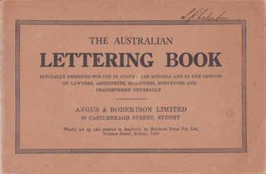
Booklet - Lettering Book, Halstead Press Pty Ltd, The Australian Lettering Book, 1945
Author Herbert Newell. Alphabets of varied fonts, headings, flourishes, plans, numerals, sketch maps, scrolls, shading, common errors, compass points. Especially designed for use in Australian Schools, offices of Lawyers, Architects, Surveyors, Engineers, Engravers, and Draughtsmen. Table of contentsThe author is a teacher of show card and ticket writing at Sydney Technical College. Book used by many students and offices. Note by the publishers provides standards for the correct form of the characters. Light brown light card cover with black ink font and border patterns. 32 Cream pages with black ink. Two staples. Hand written name on top of outline black border S. R Coleston. Price 3/9warrnambool, lettering book, angus & robertson limited, s.r. coleston, herbert newell -
 Warrnambool and District Historical Society Inc.
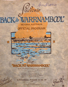
Programme - Back to Warrnambool 1930 official souvenir program, January, 1930
This booklet contains the Program for the Back to Warrnambool Celebrations for 1930. It contains a brief history of the town and photos of current council Office bearers and local scenic spots. There is also a map of the town and a large number of advertisements for local businesses. Back to Warrnambool celebrations were an important event on the social calendar and were run over a number of years in the town. This program is one glimpse into the city and its people in 1930. Some of the events held over the week included processions, sports Carnivals, concerts, card playing, Church services and local tours. Many of the advertisements are for businesses of long standing and importance to the prosperity of the town. Twenty page Booklet with light card, grey, mottled cover. Text in brown and blue. Picture of Warrnambool main beach in centre. Price 2/- in bottom right corner. Back cover has full page advertisement for Bruce and McClure. Text and illustrations are brown. M Armstrong is written in blue biro on top right corner. Song “Back to Warrnambool,” written and composed by Reg A.A. Stoneham,” is printed below picture on front cover. Published by A.A. Stoneham, 241 Carlisle St, Balaclava.younger pty ltd, warrnambool, back to warrnambool, 1930, souvenir program, warrnambool cordials, morse pty, swinton, warrnambool cheese and butter factory, batros shoes, tattersalls hotel, bruce and mcclure, warrnambool woollen mill, reg a. a. stoneham -
 Warrnambool and District Historical Society Inc.
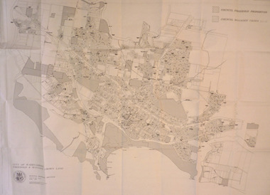
Map - City of Warrnambool Freehold and Managed Crown Land, City of Warrnambool Council, 14th April 1994
... Street (south of Merri St) Warrnambool great-ocean-road This map ...This map was drawn up by the City of Warrnambool Council staff to provide information on the land in Warrnambool that was owned or managed by the Council.This map is of considerable importance as it gives information in map form of the Warrnambool land that is owned (freehold) by the City of Warrnambool and the land that is managed Crown land. This is of interest to researchers and those seeking information on specific areas of land in Warrnambool.This map has digital mapping. The map has a white background with black and white mapping details of Warrnambool. It has the City of Warrnambool seal. Scale of map: 1:7500warrnambool city council, warrnambool -
 Warrnambool and District Historical Society Inc.
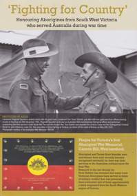
Booklet, 'Fighting for Country' Honouring Aborigines from South West Victoria who served Australia during war time, February 2014
This booklet was collated and printed for the 2014 Lake Bolac Eel Festival, ‘Return to Country’. The author, Peter Bakker, has spent several years researching the part played by south western Victorian aborigines and this booklet details the results of this research. Several of the soldiers came from the Warrnambool area.This is a booklet of ten pages with printed material and black and white and colour photographs and a map.Front Cover: ‘Fighting For Country – Honouring Aborigines from South West Victoria who served Australia during War Time’ (plus other printed material) Back Cover: Map and List of Service Men and Women of Aboriginal Descent with connections to South West Victoria aborigines from south west victoria, return to country, lake bolac eel festival, peter bakker, world war one, world war two, korean war, vietnam war -
 Warrnambool and District Historical Society Inc.
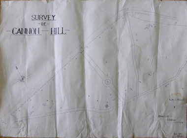
Work on paper - Project, Cannon Hill 1939, 1939
... Street (south of Merri St) Warrnambool great-ocean-road A map ...A map thought to be a school project depicting the layout of Cannon Hill, a popular lookout in Warrnambool.A locally drawn map indicative of school work from the 1930’s.A map thought to be a school project depicting the layout of Cannon Hill, a popular lookout in Warrnambool.Drawn by R Graham. Checked 13/02/1939 T E Wingrovecannon hill, school project 1939 -
 Warrnambool and District Historical Society Inc.
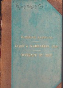
Document - Victorian Railways. Koroit & Warrnambool Line. Contract No. 2937, Circa 1888
The Victorian Railways began in 1854 and in the first 14 years up to 1868 had managed to complete about 250 miles of track. The next 60 years saw the system expand to nearly 3000 miles. By 1931 every town with a population over 500 had its own railway station. Early Victorian railway maps indicate that the extension from Colac to Warrnambool and then onwards to Koroit, occurred in the period of the 1880’s when the act known as the Octopus act saw a rapid expansion of lines. At the time there was much debate over where the expansion of the lines should take place, with one of the prime considerations for Warrnambool was the impact it would have on its port.The building of the railway to Warrnambool and onward to Koroit was a significant event for the town. Green cloth cover with tan suede corner points and spine. Title printed in gold on front cover. Title printed in gold on red on spine. 92 pages. The contract is printed and includes handwritten entries with specifications.Handwritten on front cover and inside front cover ” Copy for Engr in Chief” .On Page 2 transferred to Allan Reid * 24/1/88 Co Briscoe & Co Little Collins Street, Melbourne.warrnambool, railways, warrnambool to koroit railway, victorian railways contract no 2937 -
 Sir Reginald Ansett Transport Museum
Headwear - Hat, Side cap, c. 1940
Part of Ansett Airways hostess/stewardess uniform of 1940's era. Complements the collection of air flight crew attire.Navy hostess side cap with a cloth embroidered badge stitched on the left hand side. Badge 'AA' with map of Australia below and surrounded feathers. Lined. Double stitch Gusset on the crown. Stitching on brim which is folded onto crown.ansett airways, hostess, flight attendants, stewardess, uniform, navy, side cap -
 Eltham District Historical Society Inc
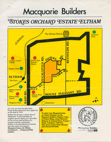
Document, Stokes Orchard Estate Eltham; Macquarie Builders, 1979c
Sales brochure including photocopy map of Stokes Place lots and Sales Manager's business card (John J. Herold). Stage 1 implemented c.1976 and Stage 2 c.1979. As shown on the plan, the lots along Diosma Road did not eventuate due to the lack of sewer system. These lots and streets were divided up into 5 acre blocks, which were not able to be subdivided till the 1990s when the sewer was run up Diosma Road. Stokes Place was part of the Stokes Orchard Estate which was developed from the break-up of the the orchard owned by Frank Stokes who lived on the northeast corner of Nyora Road and Eucalyptus Road. His daughter Beryl advised that the Shire had levied a rate assessment on individual parcels of land within the orchard which became unaffordable resulting in its sub-division and sell off. The Stokes Orchard Estate was developed by Macquarie Builders in two stages starting with stage 1 in 1976. Stokes Place was part of Stage 2 in 1979. The Estate was bounded between Nyora Road, Eucalyptus Road, Diosma Road and Stokes Place. The original orchard only just reached the left most portions of Stokes Place and did not go fully up to Diosma, rather to just beyond the extant of Stokes Place. Stokes Place was known within the family as "The Oats" as that is where they grew oats. Frank Stokes moved to Eltham c.1945 after visiting Harold Bird to view his orchard, located diagonally opposite Stokes Orchard from the intersection of Eucalyptus Road, Pitt Street and Nyora Road. It was on Harold Bird's recommendation that Frank purchased the land.The Stokes Orchard Estate collection is typical of housing developments of the late 1970s and 1980s. It was one of the earliest estates in Eltham following the nearby Woodridge Estate development.A4 colour brochure double sided, A4 photocopy and business cardAs notedstokes place, eltham, stokes orchard, stokes orchard estate, streets, houses, peter and carla vermey -
 Eltham District Historical Society Inc
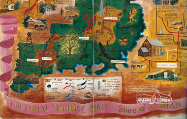
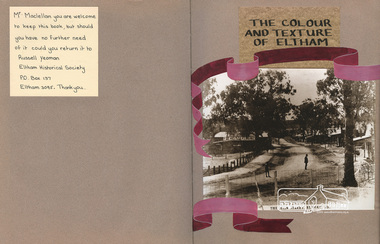
Scrapbook Album, The Colour and Texture of Eltham, 1997, 1997
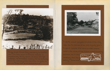
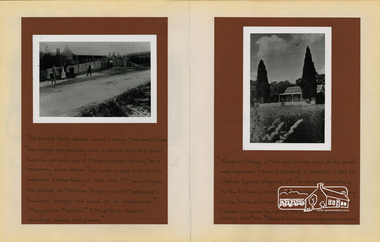
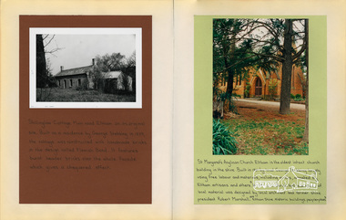
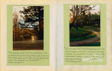
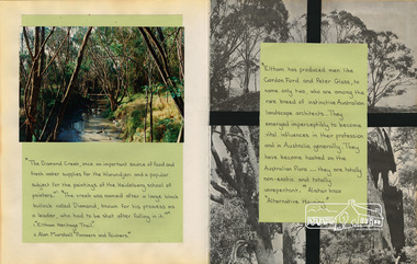
Put together by a member of the Eltham Gateway Action Group (EGAG) in participation with various artists, writers, local business people and other local citizens and sent to Minister Maclellan, Planning Minister in the Kennet Government in protest of proposed plans to sell the former Eltham Shire Office site at 895 Main Road Eltham in order to develop a Shell Service Station and Hungry Jacks fast food outlet. The purpose was to express what is unique about the character of Eltham, why people live and work there and why such a development would be out of character and inappropriate for the Eltham Gateway along with alternative development proposals. This protest was the catalyst for the formation of the Eltham Gateway Action Group, which later evolved into the Eltham Community Action Group (ECAG).Scrapbook album approx 40 x 30 x 4 cm, black hardcovers and 36 double page openings, numerous blank pages.alan marshall, alistair knox park, alistair knox, alternative proposals, ampitheatre, artists, betty langley, bohdan kucyk, bootmakers cottage, bridge street, cultural heritage map, david armfield, diamond creek, diamnond valley news, eltham art house theatres, eltham community action group, ecag, eltham gateway action group, egag, eltham library, eltham traders, eltham, flavour of eltham, george stebbing, gordon ford, hamish knox, helen lucas, hungry jacks, janet r boddy, jarrold cottage, jarrold family, john pizzey, jon weaving, lena skipper, letters, local business register, 895 main road, main road, eltham shire office, matcham skipper, ming mackay, minister maclellan, montsalvat, mudbrick, newspaper clippings, peter dougherty, peter glass, pioneers and painters, railway line, shell service station, shelltham, protests, shillinglaw cottage, shire of eltham, nillumbik shire, st margaret's anglican church, todaro, trestle bridge, wingrove cottage, charles symons wingrove -
 Eltham District Historical Society Inc
Scrapbook Album, The Colour and Texture of Eltham, 1997, 1997
Put together by a member of the Eltham Community Action Group in participation with various artists, writers, local business people and other local citizens and sent to Minister Maclellan, Planning Minister in the Kennet Government in protest of proposed plans to sell the former Eltham Shire Office site at 895 Main Road Eltham in order to develop a Shell Service Station and Hungry Jacks fast food outlet. The purpose was to express what is unique about the character of Eltham, why people live and work there and why such a development would be out of character and inappropriate for the Eltham Gateway along with alternative development proposals. This protest was the catalyst for the formation of the Eltham Community Action Group.Scrapbook album approx 40 x 30 x 4 cm, black hardcovers and 36 double page openings, numerous blank pages.alan marshall, alistair knox park, alistair knox, alternative proposals, ampitheatre, artists, betty langley, bohdan kucyk, bootmakers cottage, bridge street, cultural heritage map, david armfield, diamond creek, diamnond valley news, eltham art house theatres, eltham community action group, eltham library, eltham traders, eltham, flavour of eltham, george stebbing, gordon ford, hamish knox, helen lucas, hungry jacks, janet r boddy, jarrold cottage, jarrold family, john pizzey, jon weaving, lena skipper, letters, local business register, 895 main road, main road, eltham shire office, matcham skipper, ming mackay, minister maclellan, montsalvat, mudbrick, newspaper clippings, peter dougherty, peter glass, pioneers and painters, railway line, shell service station, shelltham, protests, shillinglaw cottage, shire of eltham, nillumbik shire, st margaret's anglican church, todaro, trestle bridge, wingrove cottage, charles symons wingrove -
 Eltham District Historical Society Inc
Scrapbook Album, The Colour and Texture of Eltham, 1997, 1997
Put together by a member of the Eltham Community Action Group in participation with various artists, writers, local business people and other local citizens and sent to Minister Maclellan, Planning Minister in the Kennet Government in protest of proposed plans to sell the former Eltham Shire Office site at 895 Main Road Eltham in order to develop a Shell Service Station and Hungry Jacks fast food outlet. The purpose was to express what is unique about the character of Eltham, why people live and work there and why such a development would be out of character and inappropriate for the Eltham Gateway along with alternative development proposals. This protest was the catalyst for the formation of the Eltham Community Action Group.Scrapbook album approx 40 x 30 x 4 cm, black hardcovers and 36 double page openings, numerous blank pages.alan marshall, alistair knox park, alistair knox, alternative proposals, ampitheatre, artists, betty langley, bohdan kucyk, bootmakers cottage, bridge street, cultural heritage map, david armfield, diamond creek, diamnond valley news, eltham art house theatres, eltham community action group, eltham library, eltham traders, eltham, flavour of eltham, george stebbing, gordon ford, hamish knox, helen lucas, hungry jacks, janet r boddy, jarrold cottage, jarrold family, john pizzey, jon weaving, lena skipper, letters, local business register, 895 main road, main road, eltham shire office, matcham skipper, ming mackay, minister maclellan, montsalvat, mudbrick, newspaper clippings, peter dougherty, peter glass, pioneers and painters, railway line, shell service station, shelltham, protests, shillinglaw cottage, shire of eltham, nillumbik shire, st margaret's anglican church, todaro, trestle bridge, wingrove cottage, charles symons wingrove