Showing 4084 items matching "road plans"
-
 Greensborough Historical Society
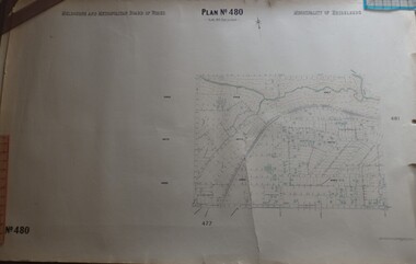
Map, Melbourne & Metropolitan Board of Works, MMBW Plan No.480, 17/10/1949
MMBW plan of part of central Greensborough, from Plenty River in North to Grimshaw Street in South, Sellars Street in West to Kerr Street in East.Map shows buildings and topography for the area.MMBW plan, black and colour ink on beige parchment, 4 copies."Scale:160 feet to 1 inch"melbourne and metropolitan board of works, mmbw, greensborough -
 Greensborough Historical Society
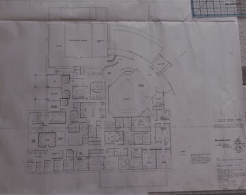
Planning Document, Shire of Diamond Valley, Civic Centre Redevelopment 1992, 1992_08
6 plans for the proposed redevelopment of the Shire of Diamond Valley offices in Civic Drive, now the offices of Nillumbik Council. Shire of Diamond Valley existed from 1964 to 1994.6 planning drawings, black ink on white paper.shire of diamond valley, nillumbik council -
 Greensborough Historical Society
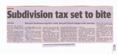
Newspaper Clipping, Subdivision tax set to bite, 13/09/2017
Mum and dad developers face being slugged with an extra tax to subdivide their properties.News article 1 page, black text.tax, subdivision plans, land development, banyule city council -
![Newspaper Clipping, Diamond Valley Leader, Student steps up bid for donated boots [Wa1810], 13/09/2017](/media/collectors/4f729f5697f83e03086015b8/items/59e192e621ea691170f13c00/item-media/5a06b51521ea6922bcd0d7f2/item-fit-380x285.jpg) Greensborough Historical Society
Greensborough Historical SocietyNewspaper Clipping, Diamond Valley Leader, Student steps up bid for donated boots [Wa1810], 13/09/2017
Watsonia student Nathan Sia is kicking goals with a plan to collect football boots for two teams in CambodiaNews article 1 page, black text, colour image.watsonia, football boots, nathan sia, loyola -
 Greensborough Historical Society
Photograph - Digital Image, Art at WaterMarc, July 2017, 22/07/2017
Photographs of an art installation by Jessie Stanley at WaterMarc Greensborough on 22/07/2017. From Jessie Stanley's FaceBook page :Dust to Dust is complete... It's an ephemeral site-specific work about how the Melbourne suburb of Greensborough has transformed over time. This area's exceptionally fertile soil [used by] by white settlers for farms, market gardens and orchards reshaped the Wurundjeri's traditional lands - and today the private sale and division of these farms informs the streetscape and town plan. With soil sourced locally this work reveals some of the area’s history - the text running around the perimeter was written by former resident Val Wilson, a snippet of her recollections of growing up in the area in the 1950s. The arrows and text act like a compass to orientate this site with greater Melbourne. On display in the lobby of Banyule Council until chance, time (or a broom) sweeps it away, Many thanks to Banyule City Council, Greensborough Historical Society and Valerie Wilson. "An artistic representation of Greensborough's history.Digital photographs of art installation.jessie stanley, watermarc, greensborough historical society, banyule council -
 Greensborough Historical Society
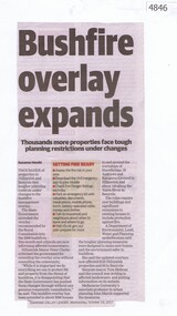
Newspaper Clipping, Diamond Valley Leader, Bushfire overlay expands, 18/10/2017
Thousands of properties in Nillumbik and Banyule face tougher planning controls under changes to bushfire management overlay. News article 1 page, black text.nillumbik, banyule, bushfire management, bushfires -
 Greensborough Historical Society
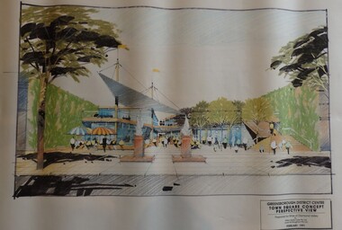
Planning Document, Shire of Diamond Valley, Greensborough District Centre, Town Square Concept Plans 1991, 1991_02
Plans and concept drawings for the proposed development of the Greensborough District Centre, Town Square. Shire of Diamond Valley existed from 1964 to 1994.7 plans and 2 concept drawings, black and coloured ink on white paper.shire of diamond valley, greensborough -
 Greensborough Historical Society
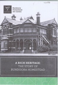
Pamphlet, City of Darebin, A Rich heritage: the story of Bundoora Homestead, 2016_
History of Bundoora Homestead, from its initial use by John Matthew Vincent Smith as a horse and cattle stud, and later as a convalescent farm and repatriation hospital until its ownership by Darebin City Council and restoration.10 p. pamphlet, col. & black & white photographs and plansbundoora homestead -
 Greensborough Historical Society
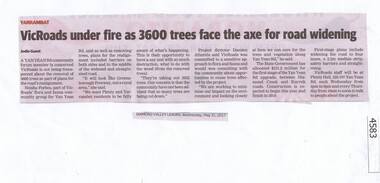
Newspaper Clipping, Diamond Valley Leader, VicRoads under fire as 3600 trees face the axe for road widening, 31/05/2017
... of plans for the road’s realignment.... the removal of 3600 trees as part of plans for the road’s realignment ...A Yan Yean Rd community forum member is concerned VicRoads is not being transparent about the removal of 3600 trees as part of plans for the road’s realignment.News article 1 page, black text.yan yean road, vicroads, tree removal, yarrambat -
 Greensborough Historical Society
Newspaper Clipping, Diamond Valley Leader, Colonists' plans for expansion, 14/06/2017
Millions of dollars have been pumped into the expansion of the Leith Park retirement village in a bid to ease the housing demand for older VictoriansNews article 1 pages, black text.old colonists, leith park -
 Greensborough Historical Society
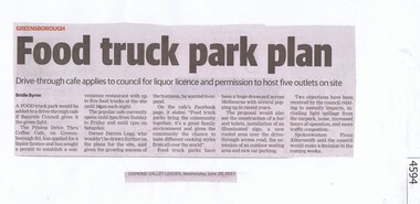
Newspaper Clipping, Diamond Valley Leader, Food truck park plan, 28/06/2017
A food truck park would be added to a drive through café if Banyule Council gives it the green light.News article 1 page, black text.pitstop cafe, food truck, banyule city council -
 Greensborough Historical Society
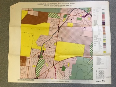
Map, Melbourne and Metropolitan Board of Works Interim Development Order 1961 Map No. 53, 27/09/1961
Denotes Zones and Reservations comprising part of the municipalities of Eltham, Heidelberg, Preston and Whittlesea, approved 27.9.61. Includes Mont Park Hospital and Watsonia Military Camp.Colour plan Date printed on plan (1959) has been over stamped with 1961. Also stamped with Government Gazette date of 27.9.1961. "Scale 800 feet to 1 inch"greensborough, watsonia -
 Greensborough Historical Society
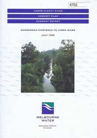
Pamphlet, Lower Plenty River concept plan, summary report: Maroondah Pipetrack to Yarra River, 1992_07
This draft concept plan covers the lower Plenty River from the Maroondah Pipe track in Greensborough to where the Plenty meets the Yarra. Melbourne Water was the lead agency, assisted by the Shires of Eltham and Diamond Valley, City of Heidelberg, the EPA and Department of Planning and Housing.Coloured pamphlet, photograph and plans 12 pages. 2 copies.plenty river, maroondah aqueduct, melbourne water -
 Greensborough Historical Society
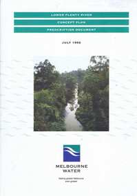
Book, Lower Plenty River concept plan: prescription document, 1992_07
Draft concept plan prepared. by Brett Cheatley, Malcolm Warren and Ian Womersley, Parks and Waterways Planning Division, Melbourne Water. Includes management areas and key strategies for the Lower Plenty River.Book, mainly black and white print, colour photographs and plans, 66 pages. 3 copiesplenty river, melbourne water, lower plenty river -
 Greensborough Historical Society
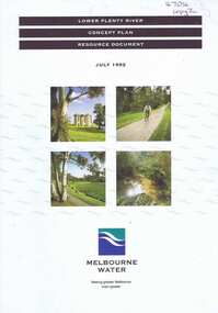
Book, Lower Plenty River concept plan: resource document, 1992_07
Draft concept plan prepared by Brett Cheatley, Malcolm Warren and Ian Womersley, Parks and Waterways Planning Division, Melbourne Water. This document includes information on the heritage and environment of the Lower Plenty River.Book, mainly black and white, colour photographs and plans, 56 pages, 3 copies.plenty river, melbourne water, lower plenty river -
 Greensborough Historical Society
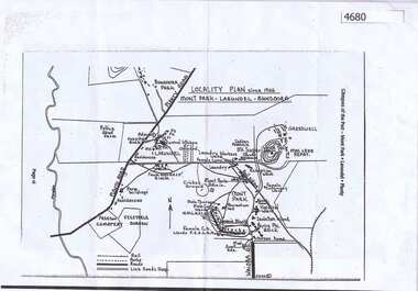
Map, Mont Park buildings still existing, 1946_
Locality Plan indicates buildings still existing within the Mont Park - Larundel mental health complex; Table lists 16 buildings by year built, initial purpose, subsequent uses and current address2 pages,one map, one table larundel, mont park -
 Greensborough Historical Society
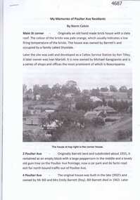
Article, Norm Colvin, My memories of Poulter Ave residents, by Norm Colvin, 28/07/2016
Details of the development and occupation of sites in Poulter Avenue and Bicton Street Greensborough, compiled by resident Norm Colvin.12 pages, text, black and white photographs and colour subdivision plan.poulter avenue greensborough, bicton street greensborough -
 Greensborough Historical Society
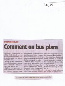
Newspaper Clipping, Diamond Valley Leader, Comment on bus plans, 16/11/2016
Several options were suggested for bus services between Wattleglen Railway Station and Diamond Valley and St Helena Secondary Colleges.News clipping, black text. st helena secondary college, public transport -
 Greensborough Historical Society
Newspaper Clipping, Diamond Valley Leader, No new schools in plan, 16/11/2016
The Banyule Schools Provision Review acknowledged that some Banyule schools would suffer high demand in coming years but no new schools would be built.News clipping, black text and colour image. banyule, education victoria, schools in banyule -
 Greensborough Historical Society
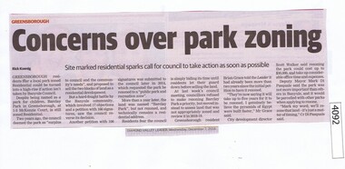
Newspaper Clipping, Diamond Valley Leader, Concerns over park zoning, 07/12/2016
Barclay Park in McKenzie Court Greensborough is still zoned residential with rezoning planned for 2018-19.News clipping, black text. barclay park, mckenzie court greensborough -
 Greensborough Historical Society
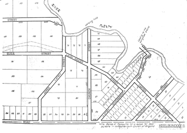
Maps, Greensborough. Parish Plan 1860, 1860c
This plan show Green's subdivision of Greensborough, north of Grimshaw Street.Enlargements of Parish plan circa 1860?One copy possibly from 1860, containing lot numbers for a government road, now Main Street, and surrounding streets.greensborough, grimshaw street greensborough, edward bernard green -
 Greensborough Historical Society
Map, Greensborough Map with Rail Line Plan, 1970s
Central Greensborough area, including railway line and some landowners. Basic map made c. 1902; annotations dated to circa 1970sTwo copies of planParish of Keelbundora, County of Bourke. Central Greensborough areagreensborough, greensborough railway station -
 Greensborough Historical Society
Document - Digital Image, Marilyn Smith, Greensborough Secondary College Gr8750 Refurbishment Plans 2016, 2016_03
This document shows the plan and finance for a refurbishment of Greensborough College 2016-2017.Digital copy of planning documentgreensborough college -
 Greensborough Historical Society
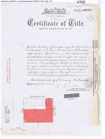
Certificate of Title, Certificate of Title Vol. 3182 Fol. 302, 15/02/1907
Title in the name of Joseph Laidlay of Greensborough, fruitgrower, 14 acres being Lots 7, 8 and 22 on Plan of subdivision 4759, part of Crown portion 17, Parish of Keelbundora County of Bourke, dated 15th February 1907. Northern boundary Greensborough (now Grimshaw) Road, Eastern boundary Henry Street.1 p. colour copy of Titlegreensborough, grimshaw street greensborough, henry street greensborough, joseph laidlay -
 Greensborough Historical Society
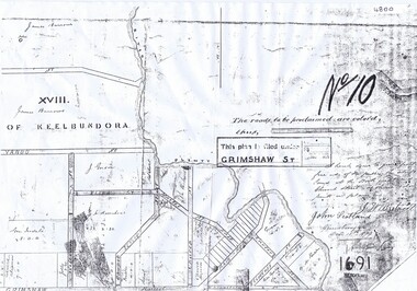
Plan, Parish Plan Map of Land North of Grimshaw Street, 11/12/1879
Part of Parish plan of land north of Grimshaw Street bounded by the Plenty River. Includes annotation signed by John Scotland and J. W. Britnell, dated Dec. 11th 1879.Photocopy of part of Parish plan of land north of Grimshaw Street bounded by the Plenty River. Includes annotation signed by John Scotland and J. W. Britnell, dated Dec. 11th 1879greensborough, grimshaw street greensborough, jonah britnell, john scotland -
 Greensborough Historical Society
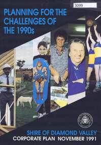
Pamphlet, Planning for the challenges of the 1990s: Shire of Diamond Valley Corporate Plan, 1991_11
Shire of Diamond Valley Corporate Plan 1991. Includes Shire map and statistics with plans for services to the community.16p. text and coloured photographsshire of diamond valley -
 Greensborough Historical Society
Newspaper Clipping, Diamond Valley Leader, Council plans oval fence; and, Enjoy a laugh to aid school, 20/07/2016
Article 1: Vandalism at Simms Road Oval has led to plans to fence the oval by Banyule Council. Article 2: A fundraiser at St Francis Xavier Primary School was used to purchase sports and library equipment. News clipping, black text and colour imagemontmorency, simms road oval montmorecy, st francis xavier primary school -
 Greensborough Historical Society
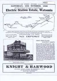
Advertising Leaflet, Electric Station Estate; Watsonia; Saturday 16th October 1926, 16/10/1926
This is one of two brochures advertising the auction of the last 50 allotments of the Electric Station Estate, Watsonia, near the new railway station. This brochure contains a locality plan and drawing of the general store. (Refer 4526 for the other brochure for this auction) Auctioneer: Knight & Harwood.One page B & W Photocopy (laminated) of auction brochure, with drawing of general store and locality planwatsonia railway station, watsonia, electric station estate -
 Greensborough Historical Society
Document, Victoria. Department of Environment Land Water and Planning, Proposed planning changes for Austin Hospital, 28/10/2016
Information on proposed changes to heritage overlays on the Austin Hospital site on Studley Road Heidelberg4p. coloured information sheet, with one page covering letter from the Government Land Standing Advisory Committeeaustin hospital -
 Greensborough Historical Society
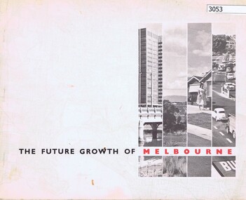
Book, The Future growth of Melbourne, 1967_06
A report to the Minister for Local Government on Melbourne's future growth and its planning administration, June 1967.46 p., text and col. plansmelbourne (victoria), mmbw