Showing 23103 items matching "sardine-creek"
-
 Lake Bolac & District Historical Society
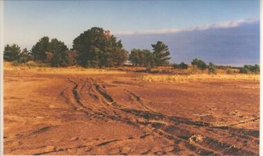
Black and white photograph, Fiery Creek Entrance
Fiery Creek inlet to Lake Bolac during the 1997-2010 drought. Photograph taken from the dry lake-bed looking up the creek, towards the south.lake bolac, fiery creek, 1997-2010 drought -
 Eltham District Historical Society Inc
Album - Photograph, J.A. McDonald, Dixons Creek Road, 23 Sep. 1955
Dixons Creek in floodRecord of various Shire of Eltham infrastructure works undertaken during the period of 1952-1962 involving bridge and road reconstruction projects, sometimes with Eltham Shire Council Project Reference numbers quoted. It was during this period that a number of significant improvements were made to roads and new bridges constructed within the shire that remain in place as of present day (2022). In many situations, the photos provide a tangible visible record of infrastructure that existed throughout the early days of the Shire. The album was put together by or under the direction of the Shire Engineer, J.A. McDonald.1955-09-23, bridge construction, dixons creek bridge, dixon's creek road, flood damage, floods, infrastructure, road construction, shire of eltham -
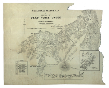 Federation University Historical Collection
Map, Dead Horse Creek, 1887, 29/05/1887
Geological sketch map of a portion of Dead Horse Creek. WGS 84 Centroid Lat: 36 degrees 50 inches S Long: 148 degrees 00 inches S NS: 4.3km EW 4.8kmdead horse creek, james stirling, gold, geology, mount cobberas -
 Whitehorse Historical Society Inc.
Photograph, Deep Creek Road, Mitcham, 1/01/2001 12:00:00 AM
Black and white photograph of Deep Creek Road, Mitcham taken from lower entrance of Schwerkolt Cottage Reserve showing Glenvale Road on left. Photo taken before work started on new road and bridge.deep creek road, mitcham, glenvale road, ringwood -
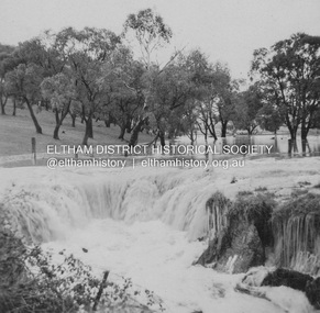
 Eltham District Historical Society Inc
Photograph, Leader Publishing Co, Floods at Diamond Creek, Sep. 1924
The Diamond Creek in flood in Diamond Creek township. View north along Diamond Street. The building in the middle distance is the Methodist Church. From "The Leader", 6 September 1924.This photo forms part of a collection of photographs gathered by the Shire of Eltham for their centenary project book, "Pioneers and Painters: 100 years of the Shire of Eltham" by Alan Marshall (1971). The collection of over 500 images is held in partnership between Eltham District Historical Society and Yarra Plenty Regional Library (Eltham Library) and is now formally known as 'The Shire of Eltham Pioneers Photograph Collection.' It is significant in being the first community sourced collection representing the places and people of the Shire's first one hundred years.Digital imageshire of eltham pioneers photograph collection, diamond creek, floods, methodist church, diamond creek (creek), diamond street, 1924 -
 Falls Creek Historical Society
Booklet - Falls Creek Cross Country Trail Guide 1999
This publication was developed by the Falls Creek Resort Management Committee to promote activities and facilities at Falls Creek for the Winter Season 1999. It was a publication specifically focused on cross country skiers. This item is significant because it illustrates how Falls Creek has been marketed and promoted over time.A coloured fold out trail guide including a map of all trailsfalls creek trails, falls creek marketing, falls creek promotion, cross country skiing -
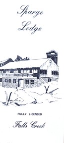 Falls Creek Historical Society
Flyer - Spargo Lodge
Ivan Spargo was a builder in Melbourne. In 1965 he and his wife Joy leased piece of land in Falls Creek and built Spargo Lodge. It was a dormitory style chalet designed to accommodate large groups and families. Their son, Rob and his wife Blanche purchased the site where the Falls Creek Hotel is today. In 1970 Rob’s sister Leonie and her husband Glenn joined the business, and they started operating in 1972. The family has been actively involved in the Falls Creek Community including the establishment of the Falls Creek Primary School and Falls Creek Search & Rescue. Rob also served as a member the Chamber and Resort Management Board. As the next generation stepped into the family business, Rob and Blanche retired to their home in Tawonga South in 2014 and Leonie and Glenn retired to Melbourne in 2017.This brochure is significant because it is linked to a prominent business and family in Falls Creek, Victoria. A small brochure publicising Spargo Lodge, Falls Creek. It is printed in brown text on buff coloured light card. When unfolded, one side shows a sketch of Spargo Lodge. The reverse side gives information about facilities and services, the tariff for regular and peak season, booking details and transport information.On front: Spargo Lodge FULLY LICENSED Falls Creekspargo lodge, falls creek accommodation, falls creek hotel -
 Greensborough Historical Society
Map, Melbourne and Metropolitan Board of Works. Survey Division, MMBW, Yarra 2500 / 15.24. Diamond Creek, Grassy Flat Road, 1978_02
Melbourne and Metropolitan Board of Works. Yarra 2500 [base map] 15.24. Diamond Creek, Grassy Flat Road. Parish of Nillumbik 3310. Municipality of Diamond Valley 257. Prominent streets include: Everleigh Drive, Broad Gully Road and Clyde Street. Features include the Diamond Creek, Nillumbik Park and Diamond Creek Reservoir.MMBW Map in 1:2500 [scale] series. Cream parchment with green tape reinforcing on edges and punched holes on left edge.mmbw, melbourne and metropolitan board of works, diamond creek - maps, shire of diamond valley -
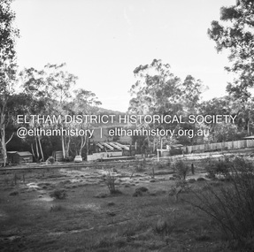
 Eltham District Historical Society Inc
Negative - Photograph, J.A. McDonald, Dixons Creek Road, c.May 1958
Dixons Creek Contractor MorrisRecord of various Shire of Eltham infrastructure works undertaken during the period of 1952-1962 involving bridge and road reconstruction projects, sometimes with Eltham Shire Council Project Reference numbers quoted. It was during this period that a number of significant improvements were made to roads and new bridges constructed within the shire that remain in place as of present day (2022). In many situations, the photos provide a tangible visible record of infrastructure that existed throughout the early days of the Shire. The album was put together by or under the direction of the Shire Engineer, J.A. McDonald.infrastructure, shire of eltham, 1958-05, bridge construction, dixons creek bridge, dixon's creek road -
 Stawell Historical Society Inc
Photograph, Salt Creek Bridge 1993 -- Coloured
Salt Creek Bridge 1993stawell -
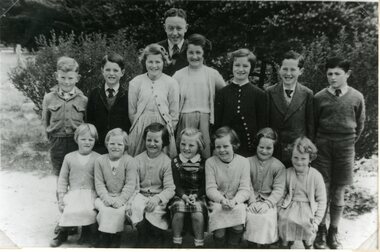 Stawell Historical Society Inc
Photograph, Greens Creek School Students 1954
Greens Creek Students 1954stawell -
 Stawell Historical Society Inc
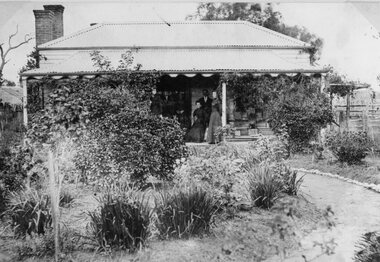
Photograph, Pearce Family Home in Doctors Creek
Pearce Home. Doctors Creekstawell -
 Stawell Historical Society Inc
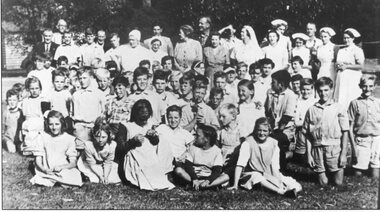
Photograph, Pleasant Creek Special School Staff and Children
Pleasant Creek Staff and Childrenstawell -
 Stawell Historical Society Inc
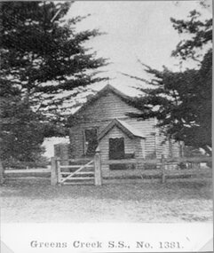
Photograph, Greens Creek School Number 1381
School - Greens Creek No. 1381 stawell education -
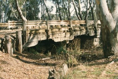
 Wonga Park Community Cottage History Group
Photograph (Item) - Black and White, Wonga Park: Old Jumping Creek Bridge, c. 1931
Old Jumping Creek BridgePhoto is named 14880026.jpg on CD -
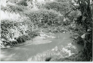 Ringwood and District Historical Society
Photograph, Mullum Mullum Creek- 29-10-89
Black and white photograph"Written on back of photograph" Mullum Mullum Creek From North bank (Munro St side)View generally downstream West of Harrison St Note rubbish and weeds. -
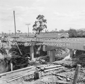
 Eltham District Historical Society Inc
Negative - Photograph, J.A. McDonald, Eltham-Diamond Creek Road, May 1958
Bridge construction Eltham-Diamond Creek road over the Diamond Creek (Wattletree Road), Eltham, May 1958 Looking from Eltham-Yarra Glen Road along future alignmentRecord of various Shire of Eltham infrastructure works undertaken during the period of 1952-1962 involving bridge and road reconstruction projects, sometimes with Eltham Shire Council Project Reference numbers quoted. It was during this period that a number of significant improvements were made to roads and new bridges constructed within the shire that remain in place as of present day (2022). In many situations, the photos provide a tangible visible record of infrastructure that existed throughout the early days of the Shire. The album was put together by or under the direction of the Shire Engineer, J.A. McDonald.1958-05, bridge construction, diamond creek (creek), eltham, eltham north, glen park bridge, infrastructure, shire of eltham, wattletree road bridge -
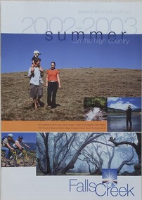 Falls Creek Historical Society
Booklet - Falls Creek Summer in the High Country 2002 - 2003
A part of a yearly marketing and information program to promote activities in the Falls Creek area outside of the winter season. This booklet promotes a wide range of activities and venues in Falls Creek and surrounding district.This item is important as it documents seasonal activities at Falls Creek Alpine area and how they have been promoted. An A4 sized marketing booklet, including images, maps and advertising information printed on glossy paper.falls creek tourism, falls creek victoria, falls creek summer -
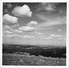 Southern Sherbrooke Historical Society Inc.
Photograph, Looking south from Black Hill Road Menzies Creek
Black and White photograph shows in the middle distance a flock of sheep belonging to Bill Hermon, south of the Breen farm in Menzies Creek. The land then falls away and flatter land fades away into the distance. There are fluffy clouds in the sky. -
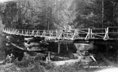 Eltham District Historical Society Inc
Negative - Photograph, Log bridge over Pheasant Creek, Kinglake, c.1920
Postcard view of pedestrian log bridge in Kinglake National Park. The log bridge over Johnston's Creek is said to have been built to allow the timber tramline to cross the creek. The bridge was destroyed in the 1926 bushfires. Other sources describe this bridge being located at Pheasant Creek (between Kinglake West and Kinglake Central) and that it was built by Mr Munro, the owner of the sawmill.This photo forms part of a collection of photographs gathered by the Shire of Eltham for their centenary project book,"Pioneers and Painters: 100 years of the Shire of Eltham" by Alan Marshall (1971). The collection of over 500 images is held in partnership between Eltham District Historical Society and Yarra Plenty Regional Library (Eltham Library) and is now formally known as 'The Shire of Eltham Pioneers Photograph Collection.' It is significant in being the first community sourced collection representing the places and people of the Shire's first one hundred years.Digital image 4 x 5 inch B&W Neg 1 printshire of eltham pioneers photograph collection, kinglake, log bridge, bridge, mr. munro, timber tramway, pheasant creek -
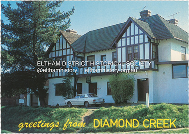 Eltham District Historical Society Inc
Postcard - Photograph, Nucolorvue Productions Pty Ltd, greetings from Diamond Creek, n.d
The Royal Mail Hotel, Diamond Creeknu-color-vue, postcard, diamond creek, royal mail hotel -
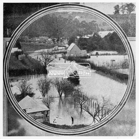
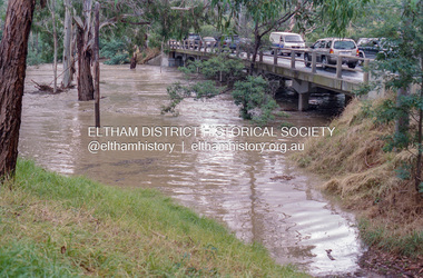 Eltham District Historical Society Inc
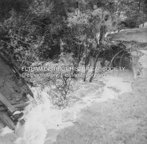
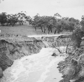
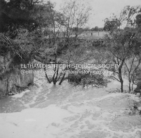
Negative - Photograph, Diamond Creek floodwaters near Main Road Bridge, Eltham, Feb. 2005
Flooding of the Diamond Creek in February 2005Roll of 35mm colour negative film, 7 strips Associated colour print 10 x 15 cmKodak GC400-8bridge, diamond creek (creek), eltham, eltham south, floods, main road, main road bridge -
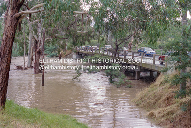
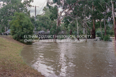 Eltham District Historical Society Inc
Negative - Photograph, Diamond Creek floodwaters near Main Road Bridge, Eltham, Feb. 2005
Flooding of the Diamond Creek in February 2005Roll of 35mm colour negative film, 7 strips Associated colour print 10 x 15 cmKodak GC400-8bridge, diamond creek (creek), eltham, eltham south, floods, main road, main road bridge -
 Stawell Historical Society Inc
Photograph, Pleasant Creek Special School Nursing Staff 1959
Pleasant Creek Nursing Staff 1959stawell -
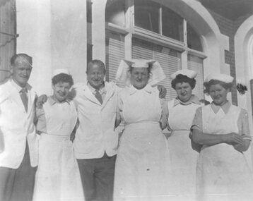
 Stawell Historical Society Inc
Photograph, Pleasant Creek Bellfield Ward 1968
Pleasant Creek Bellfield Ward 1968stawell -
 Stawell Historical Society Inc
Photograph, Pleasant Creek Bellfield Ward 1968 -- Coloured
Pleasant Creek Bellfield Ward 1968stawell