Showing 3069 items matching "scales"
-
 Ringwood and District Historical Society
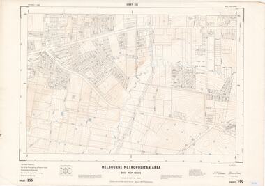
Map - Melbourne Metropolitan Area Base Map Series, Sheet 255 - Ringwood area, 1963
Map prepared by Dept of Lands and Survey and MMBW from State Aerial Survey December 1956 and Cadastral Survey information May 1963. This sheet comprises parts of the Municipalities of Ferntree Gully, Nunawading and Ringwood, and Parishes of Nunawading, Ringwood and Scoresby.Scale: 400 feet to 1 inch. Contours at 5 feet vertical interval. By Authority: A.C. Brooks, Commonwealth Printer, Melbourne. -
 Ringwood and District Historical Society
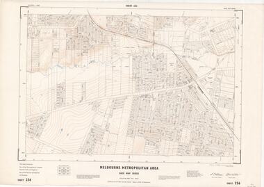
Map - Melbourne Metropolitan Area Base Map Series, Sheet 256 - Ringwood area, 1962
Map prepared by Dept of Lands and Survey and MMBW from State Aerial Survey December 1956 and Cadastral Survey information December 1962. This sheet comprises parts of the Municipalities of Croydon, Ferntree Gully, and Ringwood, and Parishes of Ringwood and Scoresby.Scale: 400 feet to 1 inch. Contours at 5 feet vertical interval. By Authority: A.C. Brooks, Commonwealth Printer, Melbourne. -
 Ringwood and District Historical Society
Map - State Aerial Survey, Dandenong Ranges Area, Parishes of Warrandyte and Ringwood - 1956
Map of central and southern areas of Ringwood and part of Ringwood East and Heathmont compiled by Dept of Lands and Survey, July 1956, from aerial photographs and Cadastral Survey information. Subsequent hand-drawn addition of streets showing layout of "Township of Ballyduffy Estate 1858-60", an earlier proposed subdivision that did not eventuate. (See attached 5009b Ballyshanassy_ Melbourne’s lost suburb.pdf for Ballyduffy historical naming relevance). Ballyduffy Estate streets include City Road, West Prussia Road, Duffy Street, Ireland Street, Evans Street, Victoria Street, Regina Street, Short Road, Prussia Road, Duffy Street East, Ireland Street East, Evans Street East, Chapman Street. Misc Topo 93 Sheet 22, Ringwood A4B2. Scale: 4 chains to 1 inch. Contour interval 20 feet. -
 Port Melbourne Historical & Preservation Society
Plan - Improvments, Beach Street, Port Melbourne, Beach Street Improvements, 9 Nov 1915
Plan for Beach Street improvements 1915 - hand drawn in ink and hand coloured.Signed by Heath and Chairman RH Gill - Scale altered in red ink from 2ft to the inch to 4ft to the inch (at bottom centre)built environment - civic, arthur victor heath, town clerks, richard henry gill, mayors -
 Ballarat Heritage Services
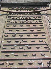
Photograph - Colour, Tracks, Ballarat Railway Station, H. Pooley & Sons, London
... Scales ...ballarat railway station, scales, weight, pooley & son, h. pooley -
 Surrey Hills Historical Society Collection
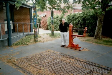
Photograph, Geoffrey Armitstead at the site of his grandfather's woodyard, Union Road, Surrey Hills, 2002 (1), 2002
Armitstead's woodyard was on the site later occupied by the Chandler Room of the Surrey Hills Neighbourhood Centre. Stephen Godfrey Armitstead started the woodyard in 1921, taking over from Long's woodyard. Taken over by Stephen's son, Leo Godfrey, it closed in the 1970s. After Leo's death it was managed by Hec Whitworth. The Armitstead family lived at 79 Croydon Road. 1931 electoral roll: Catherine Isobella, Ellen Florence, Leo Godfrey (woodworker), Stephen Godfrey (wood merchant) and William Ginchrist (joiner) at this address. Leo later lived at 75 Croydon Road. Stephen Godfrey Armitstead birth - Father's Name: Stephen Armitstead; Mother's Name: Emily Benbow; Birth Place: Hotham, Victoria; Registration Year: 1879; Registration Place: Victoria; Registration number: 23856. Spouse Name: Isabella Jane Cath Miller; Marriage Place: Victoria; Registration Place: Victoria; Registration Year: 1904; Registration number: 4534. Stephen Godfrey Armitstead death - Surrey Hills, Victoria; Age: 90; Father's Name: Stephen; Mother's Name: Emily Benbow; Registration Year: 1969; Registration Place: Victoria; Registration number: 27747. Geoffrey Armitstead, grandson of Stephen, visited the site in 2002 whilst in Melbourne from Brisbane. He recalled that during his summer school holidays that he delivered ice to household icechests. His cousin Marcia Davis, daughter of Ellen Armitstead, accompanied him and provided the family photos for copying and related her knowledge of the family history. The weighbridge and scales were moved in 2023 from their original position when the forecourt of the Neighbourhood Centre was upgraded by Council. The carved poles were also moved; they were repositioned as a group adjacent to 151 Union Road.Colour photo of Geoffrey Armitstead standing next to the scales in the Armitstead Courtyard of Surrey Hills Neighbourhood Centre. In the foreground is the weighbridge that was also part of the woodyard operated by his grandfather, Stephen Armitstead. In the background is part of the Chandler Room of the Centre and two of the carved poles which illustrate elements of the history of Surrey Hills.union road, armitsteads woodyard, surrey hills neighbourhood centre, businesses, timber merchants, timber yards, stephen armitstead, geoffrey armitstead, weighbridge, long's woodyard, leo armitstead, hec whitworth -
Clunes Museum
Plan, CLUNES WATER SUPPLY
DRAWINGS MADE TO SET UP A PERMENT PIPED WATER SUPPLY TO NEW NORTH MINE, CLUNES, VICTORIA, AUSTRALIA1 PAGE PLAN WITH DRAWING OF CLUNES WATER SUPPLY ON WAXED PAPER USING RED, BLACK AND BLUE INKCLUNES WATER SUPPLY LONGITUDINAL SECTION OF CENTRE LINE OF THE LOWER AWUEDECT FROM WEIR A TO SERVICE RESERVOIR DRAWING 420 5 CONTRACT NO. 740 2 HORIZONTAL SCALE FOUR CHAINS TO AN INCH VERTICAL SCALE FORTY FEED TO AN INCH SIGNED BY OCTAVIUS LANGTREE WORKS ENGINEER 13/12/1870octavius langtree, peter lalor, clunes water supply -
Frankston RSL Sub Branch
Computer, Navigation
Aerial Dead Reckoning Computer in leather pouch. This device was used as a navigational aid by aircraft pilots and crew. W&G Aerial Dead Reckoning Computer R.A.A.F. Mk 1 Made in Australia by White & Gillespie Front Scale: Distance Naut Miles, True Air Speed (Time Min, Hrs, Density Altitude, Air Temp ) Back Scale: Wind Correction Angle( True Heading ) The leather pouch has the following printed on the outside "W&G Aerial Dead Reckoning Computer R.A.A.F. Mk 1" -
Clunes Museum
Map - DOCUMENTS/MAP, 3 1887. .4 1891
MINING, CLUNES GOLD MINES, MAPS, SECTIONS.1 AERIAL VIEW OF CLUNES AND DISTRICT. COLOUR PHOTOGRAPH LAMINATED. .2 MAP OF MINING AREAS SHOWING EXCISED AREA. No. 9104. MINING DISTRICT OF BALLARAT. PARISH OF CLUNES. COUNTY OF TALBOT. SCALE 4 CHAINS TO AN INCH. .3 MAP OF GOLD MINING LEASE BLOCKS AT CLUNES .4 DRAWINGS OF SECTIONS, CLUNES GOLD MINES. SCALE 400 FEET TO AN NCH. ALL MOUNTED WITH PLASTIC HANGING STRIPS..1 ON BACK. CLUNES 1:25000 .2 ASSORTED HANDWITTEN NOTATIONS. .3 ASSORTED HANDWITTEN NOTATIONS. REPLACE IN DEPT. OF MINING REGISTRARS QUARTER ENDED 30TH JUNE 1887. P. 12.clunes, gold mining, leases, aerial photograph, mine sections -
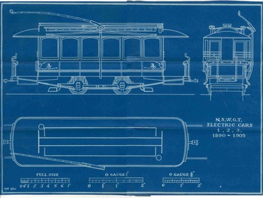 Ballarat Tramway Museum
Plan, Ken McCarthy, "NSWGT - Electric trams 1,2,3 1890 - 1900", May. 1960
Yields information about the nature of the trams that came from Sydney to Ballarat for the first electric tramcars and has a strong association with the person who prepared by the plan.Blueprint plan of NSW Govt. Tramway cars 1,2,3,- Roof plan, front and side elevation - with side running trolley poles - 3/8"=1' scale with O gauge 1/4 and O gauge 3/8" scale marked. (These cars become part of the 1905 ESCo Ballarat Fleet). Imaged by scanning in two halves and joining together - could do some further work.trams, tramways, nswgt, plans, tramcars, esco -
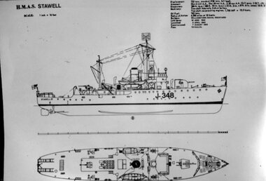 Stawell Historical Society Inc
Photograph, H.M.A.S. Stawell Corvette Class -- Scale Drawing
Corvette H.M.A.S. STAWELL Scale Drawingstawell ww2 -
 Warrnambool and District Historical Society Inc.
Document, Map: Lady Bay 1853, 1853
This is one of the earliest surveys and maps of Warrnambool harbor, Lady Bay. Being done in 1853, it shows the depths of the bay area marked in fathoms, currents and directions and areas of rocks around mouth of the Merri and the Western side of the bay as well as a large sand spit to the middle right of the beach region.. It also marks the large areas of seaweed and fuci in the outer bay area. It has the area of Pertobe Lagoon marked and shows the early tracks to the town. The engraving work was done by Tulloch and Brown, with Tulloch being one of the earliest engravers and lithographers in the state of Victoria. He arrived in Melbourne in 1849 and set up business with James Davie Brown in 1853 with Brown being a map engraver. They were awarded bronze and silver medals for their work at the Victorian Industrial Exhibition. He also worked in the vignettes on the Proeschel Map of Victoria.This map is of high historical and comparitive significance as it shows the Lady Bay area prior to the changes that have occurred in the last 160 years with the building of the breakwater. The issue regarding access to Lady Bay remains a current one. The engraver D Tulloch engraved some of the earliest scenes of the goldfields in Ballarat and as such has left a record of a very early and important era in Australian history. Rectangular cream paper with black text. Map area is outlined by fine black lined border. Key in top right hand corner and scale at bottom middle of map.Map is labelled Town of Warrnambool printed at top of map. Small logo at top right corner which has “Hydrographic Department” in circle around an anchor. Lady Bay Warrnambool Surveyed by John Barrow assistant surveyor Engraved by Tulloch & Brown in bottom right corner. Melbourne engraved by order of the legislative Council of Victoria in middle bottom.map, warrnambool, town of warrnambool map 1853, tulloch & brown map 1853, lady bay warrnambool,, warrnambool harbour, warrnambool breakwater, warrnambool beach -
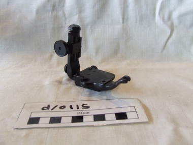 Waverley RSL Sub Branch
Sight for 40 Cal Deck Gun
On 2nd July 1955 Warramunga and Arunta became the first RAN Ships to join the force countering communism during The Malayan Emergency. Other ships which served during the emergency were HMA Ships Quickmatch, Queenborough, Anzac, Tobruk, Vampire, Vendetta, Voyager, Melbourne and Quadrant. Some of which took part in Bombardments against the CT's in Johore State.Identified by Barry McKilop ex RANBlack painted metal object with 4 thumb screws adjustments and 2 vernier scales. Mounting has one cut out and 2 screw or pin guide holesParkerdale England Mk VII PH5Agun sight, deck gun -
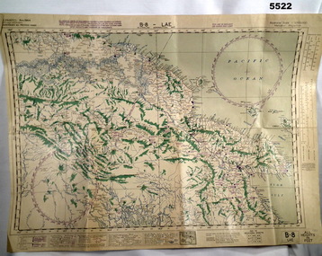 Bendigo Military Museum
Map - AERONAUTICAL MAP of LAE AREA, RAAF et al, Aug 1944
Refer to Cat 5547 for Matheson.This map is on heavy paper. it is coloured and on one side only. Scale 1:1,000,000. The top centre is the Ramu Valley. Right side is Finchafen, bottom town is south of Salamaw.It shows in pencil where ...were dropped at Nadzab. the enemy track heading NW up to Dumpu. Then movements around Astrolab Bayww2, new guinea, map -
Glenelg Shire Council Cultural Collection
Photograph - Photograph - aerial view of Portland coast, c. 1954
Black and white aerial photograph of coastline around Portland. Black border, scale all sides, 5 rows of 3 't' at regular intervals. Ocean, land with lakesFront: '820 -8' - handwritten, white, lower border 'RUN 5' 'PORTLAND', printed, white, lower borderaerial photography, central portland, portland harbour, south west coastline -
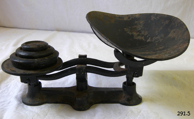 Flagstaff Hill Maritime Museum and Village
Instrument - Scale
Scale metal 3 parts; dish, weights and balance mechanism. In this case the 3 weights have been glued together and onto this platform side of the balance mechanism. Black.flagstaff hill, warrnambool, shipwrecked-coast, flagstaff-hill, flagstaff-hill-maritime-museum, maritime-museum, shipwreck-coast, flagstaff-hill-maritime-village -
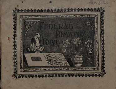 Federation University Historical Collection
Booklet - Sketchbook, Sketchbook in Geometry, 1920
Keith Rash was a student of the Ballarat Junior Technical School.Art Student's Drawing Book completed by Keith Rash. It has been used for geometry, including Scale Drawing, Plant Form, Freehand Drawing, Geometry, Model Drawing.geometry, keith rash, ballarat junior technical school -
Bendigo Historical Society Inc.
Map - PLAN NEW CHUM LINE OF REEF
Plan showing outcrops of reefs on supposed extension south of the New Chum line of reef from the Eureka extended company's ground. Scale 8 chains to 1 inchplan, bendigo, new chum line of reef -
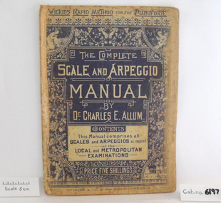 Coal Creek Community Park & Museum
Music Book, The Complete Scale and Arpeggio Manual
Music book, "The Complete Scale and Arpeggio Manual by Dr. Charles E. Allum" Front cover has a blue and white floral design with illustrations of the four seasons in the corners. -
Clunes Museum
Book, CASTLEMAINE MAIL, THE PENNYWEIGHT KIDS 1852 - 1857, 1988
SMALL VOLUME RELATING TO DEATH OF CHILDREN ON THE GOLDFIELDS AT FOREST CREEK, VICTORIA, 1852-1857YELLOW COVER WITH IMAGES DRAWN IN BLACK INK BY THE AUTHOR, OF A SET OF GOLD SCALES, A MAN WASHING GRAVEL THROUGH A CRADLE FOR GOLD AND A WOMENT LOOKING OVER A CHILD'S CRADLEnon-fictionSMALL VOLUME RELATING TO DEATH OF CHILDREN ON THE GOLDFIELDS AT FOREST CREEK, VICTORIA, 1852-1857local history, book, forest creek victoria australia, children on the golddfields -
Rutherglen Historical Society
Steelyard scales, 1930 (Approximate)
Used for weighing bullocks. Can weigh up to 500lbs. Can be turned upside down for extra weighing facility. Information from Lyle Ruddell of Toora when visiting Common School Aug 1986Scales consisting of long metal bar with pear shaped weight attached, with hooks (3) for hanging item to be weighed. Weights and measures approval circular spot near numberweight measurement, cattle, lyle ruddel, bullocks -
Beechworth Honey Archive
Map- Albury
Map centred on Albury, showing Wodonga, Beechworth, Yackandandah and Chiltern. Topographic survey scale 1:100,000. Map is colour, printed on paper. Produced by Department of Minerals and EnergySheet 8225 (ed.1) series R. 652 Notes written on side regarding brigade boundaries, constructed access roads and fire trails, dams suitable for quick fill pump and areas 'fuel reduction burns Autumn 76'.map, albury, wodonga, beechworth, yackandandah, chiltern, paper, topographic, beechworth honey -
Beechworth Honey Archive
Map- Yackandandah
(2x) Map centred on Yackandandah, showing Myrtleford- Yackandandah Rd, Mt Stanley + Mt Big Ben. Scale 1:50,000. Paper white on back, yellow on front.Albury series R625 Blue ink marked '74-75' on top of one map.map, yankandandah, paper, beechworth honey -
University of Melbourne, Burnley Campus Archives
Plan, Nicole Faulkner, Rose Garden 'Banyule', 1989
Planting Plan for 'Banyule', 72 Buckingham Drive, Heidelberg by Nicole Faulkner for Grad. Dip. Horticulture. Sheet 4 of 4, dated November 1989. Scale 1:100.rose garden, nicole faulkner, "banyule", heidelberg -
University of Melbourne, Burnley Campus Archives
Plan, Jordan Hansen, David Aldous Turf Memorial Garden Landscape Concept Plan, 2016
Landscape Concept Plan designed by Jordan Hansen for Andrew Smith LCP-001 David Aldous Turf memorial Garden 2016 - page 18. Scale 1:100andrew smith, jordan hansen, landscape design -
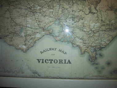 Parks Victoria - Mount Buffalo Chalet
Map, "Railway Map of Victoria"
Large framed map of Victoria, showing Victorias extensive rail network. Printed by Victorian Railways and is one of a number of 'framed pictures, particularly photographs of scenery, which have always been a feature of the Chalet.' (Pg 83. Historica, 2011) This map has been a permanent fixture situated in the hallway alongside the ballroom leading to the ski hire area since the 1950's and most likely earlier. Listed in Draft Inventory of Significant Collection ItemsLarge railway map of Victoria, Melbourne & Ballarat framed in white painted wood. Scale eight miles to one inch. Areas of the map have been whited out.Yes -
University of Melbourne, Burnley Campus Archives
Plan, Delysia Westwood, Tree Survey Central Gardens, 1986
Numbered plan with legend of trees in Central Gardens [Hawthorn]: Height, Diameter, Rating and comments for each tree. Dated November 1986 by Delysia Westwood. Scale 1:500.delysia westwood, tree survey, central gardens -
University of Melbourne, Burnley Campus Archives
Map, Drainage & Contours City of Hawthorn, c. 1970
Copy of map with some coloured and pencil annotations. Scale 1:2000. Marked "2". Area bounded by Glenferrie Road, Power Street, Barkers Road, Burwood Roadhawthorn, glenferrie sports ground, grace park, contours -
University of Melbourne, Burnley Campus Archives
Plan, 'Burnley Park', 1987
Tracing paper copy dated July 1987. Landscape Graphics - Assignment One, 'Burnley Park' Site Plan. Scale 1:100. Includes contours and existing trees.burnley park, trees, landscape graphics -
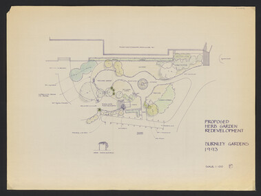 University of Melbourne, Burnley Campus Archives
Plan, Jill Kellow, The Herb Garden V.C.A.H. Burnley, 1993
Was held in Phil Tulk's office. Proposed Herb Garden redevelopment Burnley Gardens 1993 (probably drawn by Jill Kellow). Scale 1:100. Also hand drawn rough plan of the position in the gardens. herb garden, phil tulk, andrew smith, jill kellow