Showing 16825 items
matching snowy-river-bridge-1976
-
 Phillip Island and District Historical Society Inc.
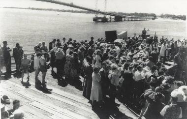
Photograph, Suspension Bridge, 1940
Official opening of Suspension Bridge 1940. Opened by Hon. Albert Dunstan LMHCrowd on work platform. View of new Suspension Bridge at Official Opening. Priest at Lectern at middle right. local history, photographs, civil engineering, bridges, official bridge opening, black & white photograph, jack jenner collection, phillip island bridges, public construction -
 Port Melbourne Historical & Preservation Society
Book - History, Olaf Ruhen, Port of Melbourne 1835-1976, 1976
Produced 1976 for the MHT Centenary.324pp history of the port - 'Port of Melbourne 1835 - 1876" by Olaf Ruhen. Brown, cloth-bound, stamped in gold on spine only; beige dust jacket with overall early painting of Melbournemelbourne harbor trust - port of melbourne authority, celebrations fetes and exhibitions -
 Kew Historical Society Inc
Map, MMBW, River Yarra Beautification Schemes, c.1913
The Melbourne and Metropolitan Board of Works (MMBW) was established by an act of the Victorian Parliament in 1890 to prepare for and to implement a sewerage and water reticulation system across what was then inner Melbourne, its surrounding and middle distance suburbs, including Kew. The MMBW was disbanded in 1991.The map collection of the Kew Historical Society has at its core the historic maps assembled and originally stored in the City Engineer's Department of the City of Kew. These include maps in a number of scales. The vast majority of maps were produced by the MMBW in the first two decades of the twentieth century, and are solid working maps, backed by linen for durability. These maps are historically significant to Kew, the City of Boroondara and to the history of the development of state utilities in Victoria. A number of the Kew maps have additional details added by former municipal officers, including the levels reached by various floods. As these were working documents, information was added to them long after the period of their initial production and distribution.Map of the City of Kew showing part of the River Yarra Beautification Schemes. The map shows development to date and the flood levels reached in 1923 and 1924. This map may have been adapted from an earlier map, as most development in central Kew and Studley Park had occurred by this date yet numerous streets are not represented. Public buildings and institutions are clearly represented and named on the map as are significant public transport infrastructure (eg the Outer Circle railway).MELBOURNE AND METROPOLITAN BOARD OF WORKS / RIVER YARRA BEAUTIFICATION SCHEMES / SCHEME / SCALE 10 CHAINS TO AN INCHmelbourne & metropolitan board of works, mmbw maps, mmbw plans, city of kew, flood levels -- kew (vic.), cartography -
 Phillip Island and District Historical Society Inc.
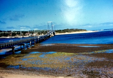
Photograph, First Phillip Island Bridge, Pre 1968
Original Phillip Island bridge which was replaced in 1968Large coloured photo of the first Phillip Island Bridge looking from Newhaven towards San Remo at low tide.Nilnewhaven, phillip island bridge, san remo -
 Federation University Historical Collection
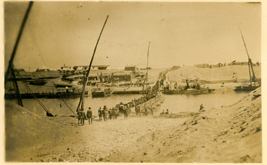
Postcard, Crossing the Suez via Pontoon Bridge, 1915
During WWI some AIF soldiers were located at the Suez in Egypt.Postcard with sepia photograph of Suez canal with soldiers crossing a pontoon bridge.Verso: "POST CARD" at centre top, "Correspondence" LHS top and "Address" RHS top "No 2" in black ink handwritten on top LHS corner. Handwriting blacked out on centre. "crossing the Suez via Pontoon Bridge" in pencilsuez, soldiers, wwi, world war one, canal, pontoon bridge, holmes, anzac -
 Mt Dandenong & District Historical Society Inc.
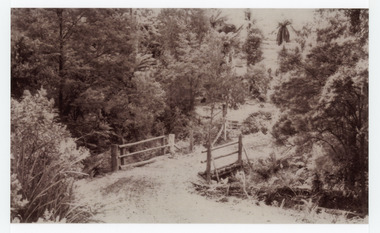
Photograph, The Crescent Bridge, Sassafras
Photograph taken at the bottom of the hill on 'The Crescent' at Sassafras where the Crescent Bridge crosses the Sassafras Creek.Black and white cop of a photograph showing a bridge crossing an unmade road over creek. Bush in background.sassafras, sassafras creek, crescent bridge, bridge, the crescent, bush, tree ferns -
Glenelg Shire Council Cultural Collection
Document - Engineering report - typed, 10/02/1964
Five foolscap pages with typed information and photographs, Dartmoor Hamilton Road, Bridge over Humphy's Creek. Stapled top left, signed by E.J.E. Byrne, Bridge Inspecting Engineer.engineering, professional report, bridge, building works, dartmoor -
 Phillip Island and District Historical Society Inc.
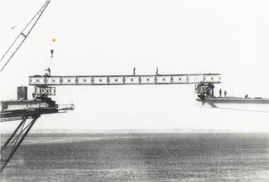
Photograph, Phillip Island Bridge, 1968/9
1969 Phillip Island Bridge under construction. From the Jack Jenner Collection.Joining Girder between two sides of new Bridge. Part of crane shown. Men on the girder and each side.local history, photographs, civil engineering, bridges, phillip island bridge under construction, black & white photograph, jack jenner collection, phillip island bridges, public construction -
 Federation University Historical Collection
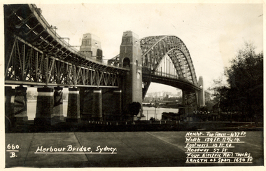
Postcard, Kodak, Sydney Harbour Bridge, c1949, 13/10/1949
Postcard written by Frank Wright to a friend, W. Snelling in London. Frank Wright was a renown resident of Smeaton, where he was born. He lived at Laura Villa, and attended Smeaton State School. His father William was a gold miner and his mother's name was Sarah. Their family won many singing and instrumental awards. Frank was tutored by Percy Code and was awarded a gold medal for the highest marks in the ALCM examinations in the British Colonies at the age of seventeen years. He became the Australian Open Cornet Champion by the age of eighteen. A year later, Frank conducted the City of Ballarat Band, and later the Ballarat Soldiers’ Memorial Band. He formed the Frank Wright Frisco Band and Frank Wright and his Coliseum Orchestra. These bands won many South Street awards, and Frank as conductor won many awards in the Australian Band Championship contest. In 1933 Frank Wright sailed to England to conduct the famous St Hilda’s Band and was later appointed Musical Director of the London County Council, where he organized many amazing concerts in parks, in and around the London district. He was made Professor of Brass and Military Band Scoring and conducted at the Guildhall of Music and Drama. Frank was often invited to adjudicate Brass Band Championships around Europe, in Australia, including South Street and in New Zealand. The Frank Wright Medal at the Royal South Street competition is awarded to an individual recognized as making an outstanding contribution to brass music in Australia.Black and white photograph of the Sydney Harbour Bridge. A small section of the city and water can be seen beneath the arched span of the bridge.Written in white on front - 660.B, Harbour Bridge, Sydney., Height-Top arch - 437 ft.,Width 159 ft. 11 3/4 in., Footways 10 ft. ea., Roadway 57 ft., Four Electric Rail Tracks., Length of span 1650 ft. Handwritten on back - Message to W. Snelling in London from Frank Wrightfrank wright, cornet, conductor, sydney harbour bridge -
 Phillip Island and District Historical Society Inc.
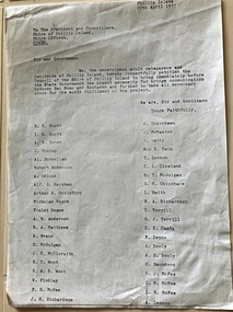
Document, Petition for bridge between Phillip Island and San Remo 1937
On 29 November 1940, a suspension bridge opened between San Remo on the mainland and with Newhaven on Phillip Island. The 540 metre bridge had two lanes but no footpaths, instead having six pedestrian refuges. The main span was 168 metres long. The cables had previously been used on a bridge on Sydney's North Shore. Because of weight restrictions, tourist coaches had to offload their passengers. [Wikipedia]HistoricalFoolscap size photocopy of a petition to Shire of Phillip Island for a bridge to Phillip Island in 1937. Signed by 42 local residents and ratepayers.first phillip island bridge to san remo, phillip island suspension bridge, petition, odlum, ockleford, regos, mcguigan, west, mcfee, richardson, underdown, mcmaster, cleeland, neely, leeson, saunders, scott, brown, hislop, donnellan, rackham, findlay, anderson -
 Ballarat Heritage Services
Photograph - Photograph - Colour, The Edna Walling Bridge at Locarno Spring in the Hepburn Springs Reserve, 2020, 12/12/2020
The Hepburn Springs Progress Association invited Edna Walling the the Hepburn Springs Reserve, and sandstone paths and bridges resulted. In 1934 there was a proposal to spend 2,000 to 3,000 poinds at the Hepburn Springs Reserve, with a govenrment loan suggested. Colour photograph of the stone bridge at Locarno Spring in the Hepburn Springs Reserve.hepburn springs, locarno, mineral water, hepburn springs reserve, locarno spring, edna walling -
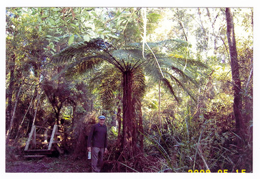 Marysville & District Historical Society
Photograph (item) - Colour photograph, 15-05-2008
A colour photograph of the wooden bridge crossing the Taggerty River. A colour photograph of the wooden bridge crossing the Taggerty River. 2008 05 15taggerty river, wooden bridge -
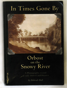 Orbost & District Historical Society
book, In Times Gone By, 2002
The book was written by Deborah Hall in order to preserve the memories of Orbost locals as well as to record its early history. Local history tends to be less documented than other types, with fewer books and artifacts than that of a country or continent. Many local histories are recorded as oral tales or stories and so are more vulnerable than more well known issues. Because it records in a scholarly way the meories of local residents, Deborah Hall's book is a commonly used reference for the early history of Orbost and districtA 158 pp book titled In Times Gone By Orbost on the Snowy River. It is a photographic record of early Orbost and District. It has a dark green coverwith a photograph of the first pile bridge over the Snowy river at Orbost. The book was authored by Deborah Hall.orbost-history reminiscences hall-deborah -
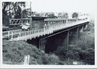 Kew Historical Society Inc
Photograph - Chandler Highway Bridge, 1977
The heritage listed Fairfield Bridge was originally constructed for the Outer Circle Railway to bridge the Yarra River between East Kew and Fairfield stations. In the 1930s it was converted for vehicular traffic. In the 2010s a new concrete bridge was erected beside it to increase vehicular capacity.Print copy of the Chandler Highway Bridge, [formerly the Fairfield Viaduct of the Outer Circle Railway] showing the original position of the walkway beside the bridge. The POV is from the Fairfield side looking towards Kew. CHANDLER HWY BRIDGE OVER YARRA / OCTOBER 1977 / ORIGINALLY BUILT FOR OUTER CIRCLE RWYchandler highway bridge, outer circle railway viaduct, bridges -- kew (vic.) -
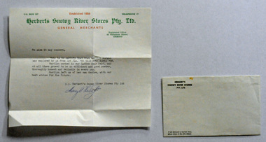 Orbost & District Historical Society
letter, 1968
Massey Herbert was a prominent Orbost citizen being the youngest candidate In Orbost's history to have been elected to the shire council. This letter was written by Massey Herbert for Marilyn Morgan as a job reference. Marilyn worked at Herbert's Snowy River Store in Nicholson Street, Orbost from 1.1.1966 until 27.4.1968.Associated with a well-known Orbost business which started in 1888 and finally closed in c.1970.A typed letter of reference from Massey Herbert for Marilyn Morgan. It is typed on a Herbert's Snowy River Pty Ltd letter head. The header is green and red print and the text black. The envelope is 2599.2.herbert-massey snowy-river-stores morgan-marilyn -
 Eltham District Historical Society Inc
Photograph, Para Road Bridge construction, Briar Hill, near Greensborough, c.1971, 1971c
Three black and white photographs; two showing construction works of the bridge over the Plenty River at Briar Hill and one of Greensborough Park, Grimshaw Street, summer 1971-1972greensborough, briar hill, para road, bridges, construction, plenty river -
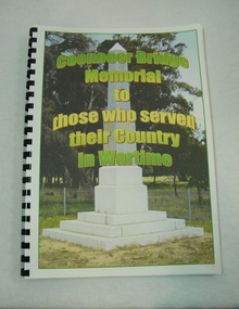 St Arnaud and District Historical Society
Book. Coonooer Bridge Memorial, Coonooer Bridge Memorial to those who served their Country in Wartime
Following the Great War of 1914-18 the people who lived in the general area around Coonooer Bridge , (18 kms from St.Arnaud ) erected a Monument in honour of those men and women who served their country in a time of war. In 1920 the monument was erected across from the hall, situated in a small pine plantation which was also planted by community members. The names of those that served their country during war time were placed on the monument. After the 2nd World War the names of the local men and women who once again were asked to serve their country were added to the memorial to honour and remember the sacrifice that they made.This book was compiled to honour and enable families and future generations to remember those who served.This is the only book listing these servicemen that served from the Coonooer Bridge Area.Spiral plastic bound book.Clear perspex cover. Coloured pages.Includes photographs of servicemen, medals and war service information.Dedicated to the people of Coonooer Bridge. -
Federation University Historical Collection
Booklet - Report, Regional College Development Planning Paper, 1976
Ballarat School of Mine's 'Regional College Development Plan' for the Lydiard Street Campus. It includes minutes of meeting in 1976.ballarat school of mines, ballarat regional college, graham beanland, ballarat technical school, ballarat girls'high school, mount clear technical high school, tertiary orientation program, campus plan, smb campus plan -
 NMIT (Northern Melbourne Institute of TAFE)
Photographs: PTS 1976 & 1977 Students in classes and library
Black and white photographs of Preston Technical School students in Technology and Audio-Visual classes and in the Library in 1976 and 1977.preston technical school, students, nmit -
 Kew Historical Society Inc
Photograph, Chandler Highway Bridge, 1930s
The railway viaduct linking the Outer Circle railway from Kew to Fairfield was constructed in the 1890s. In the 1930s it was converted into a motorway bridge.Photocopy of a photograph of the bridge linking Kew and Fairfield. Dated to the 1930s following the construction off the Chanler Highway.outer circle railway, viaduct (kew fairfield), john monash, chandler highway bridge -
 Phillip Island and District Historical Society Inc.
Photograph, Suspension Bridge, 1939-1940
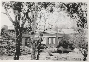
Phillip Island's first Bridge for vehicular traffic under construction. Phillip Island Suspension Bridge under construction - angled view taken from San Remo with small boat at middle leftlocal history, photographs, civil engineering, bridges, phillip island - suspension bridge, black & white photograph, jack jenner collection, phillip island bridges, public construction -
 Kew Historical Society Inc
Photograph, Willsmere Bridge, 1934
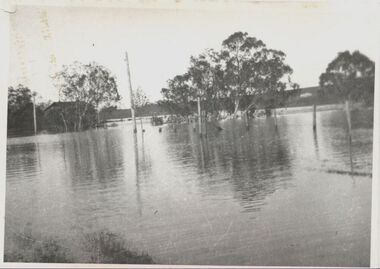
Several boathouses were built in Kew and Fairfield in the late 19th and early 20th centuries. They included Chipperfield’s ‘Moorings’ and floating pontoon. The substantial two-storey house was named the Moorings, and incorporated an upper storey residence. The Moorings was almost washed away in the 1916 floods, and in 1934 almost totally submerged when the Yarra River rose 26 feet in 14 hours. Following the 1934 flood, the house was restored. The floating pontoon, sometimes referred to as a ‘kiosk’ or ‘canteen’, was used to store canoes. Both were removed in 1972 for the construction of the Eastern Freeway.This work forms part of the collection assembled by the historian Dorothy Rogers, that was donated to the Kew Historical Society by her son John Rogers in 2015. The manuscripts, photographs, maps, and documents were sourced by her from both family and local collections or produced as references for her print publications. Many were directly used by Rogers in writing ‘Lovely Old Homes of Kew’ (1961) and 'A History of Kew' (1973), or the numerous articles on local history that she produced for suburban newspapers. Most of the photographs in the collection include detailed annotations in her hand. The Rogers Collection provides a comprehensive insight into the working habits of a historian in the 1960s and 1970s. Together it forms the largest privately-donated collection within the archives of the Kew Historical Society.A view of flooded areas in North Kew in the flood of 1934.Willsmere Bridge. Chipperfields. 1934 floodwillsmere, flood, yarra flood, chipperfields, chipperfields boathouse, north kew -
 Power House Rowing Club
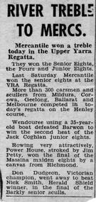
Newspaper clipping, RIVER TREBLE TO MERCS, 1958
RIVER TREBLE TO MERCS -
Lakes Entrance Regional Historical Society (operating as Lakes Entrance History Centre & Museum)
Photograph, Caire, Nicholas John, 1905c
Latrobe Bridge - Open. The bridge is swung into this position when the steamers pass down to the Lakes or return to Sale.Black and white photograph of the Latrobe River Bridge over the Latrobe River, shows the bridge open to river traffic, with a good view of the supporting structure. Sale Victoriawaterways, bridges, civil engineering -
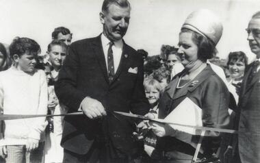 Phillip Island and District Historical Society Inc.
Photograph, Phillip Island Bridge Opening, 1969
Official Opening of 2nd Bridge, 1969, connecting San Remo and Newhaven. From the Jack Jenner Collection.Close up of Hon. Porter & Mrs Porter cutting ribbon at Opening of Bridge. Children & other spectators in background.local history, photographs, civil engineering, bridges, opening of phillip island bridge, black & white photograph, jack jenner collection, phillip island bridges, public construction -
 Greensborough Historical Society
Photograph - Digital image, Plenty River in Flood 2017: Graffiti, 14/12/2017
Photograph of graffiti on the Plenty River bridge, Greensborough. This flood was in December 2017.Digital copy of colour photograph.plenty river, floods, graffiti -
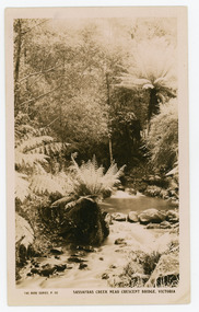 Mt Dandenong & District Historical Society Inc.
Photograph, Sassafras Creek Near Crescent Bridge. Victoria
Rose Series post card # P. 90. Sassafras Creek near The Crescent Bridge. View of water and ferns. Post 1920.Rose Series sepia coloured post card showing a small creek running through the centre of the photo edged by rocks and tree ferns.On front: The Rose Series, P. 90. SASSAFRAS CREEK NEAR CRESCENT BRIDGE. VICTORIA.sassafras creek, crescent bridge, creek, bridge, tree ferns, rose series, post card -
Bendigo Trades Hall Council & Literary Institute Inc.
Hard bound Book, Year book Australia 1975-1976
Hard bound Book Year book Australia 1975-1976 No 61 Australian Bureau of Statistics