Showing 172142 items matching "streets "
-
 Marysville & District Historical Society
Photograph (Item) - Colour photograph, Unknown
A colour photograph of Murchison Street in Marysville in Victoria.A colour photograph of Murchison Street in Marysville in Victoria.murchison street, marysville, victoria, photograph -
 Marysville & District Historical Society
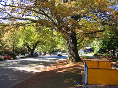
Photograph (Item) - Colour photograph, Travel Victoria, 2006
A colour photograph of Murchison Street in Marysville in Victoria.A colour photograph of Murchison Street in Marysville in Victoria.murchison street, marysville, victoria, photograph -
 Marysville & District Historical Society
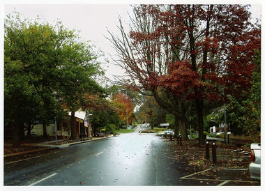
Photograph (Item) - Colour photograph, Travel Victoria, 2006
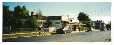
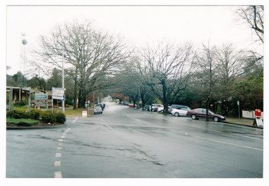
A colour photograph of Murchison Street in Marysville in Victoria.A colour photograph of Murchison Street in Marysville in Victoria. Shows the view looking down Murchison Street from Pack Road. The buildings that can be seen in the photograph were all destroyed in the 2009 Black Saturday bushfires.murchison street, pack road, marysville, victoria, photograph, 2009 black saturday bushfires -
 Marysville & District Historical Society
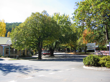
Photograph (Item) - Colour photograph, Travel Victoria, 2006
A colour photograph of Murchison Street in Marysville in Victoria.A colour photograph of Murchison Street in Marysville in Victoria. Shows the view looking down the street towards the F.J. Barton Bridge. All the buildings that can be seen in the photograph were destroyed in the 2009 Black Saturday bushfires.murchison street, marysville, victoria, photograph, 2009 black saturday bushfires, f.j. barton bridge -
 Bendigo Historical Society Inc.
Postcard - Alice McGregor Postcard Collection, 1900 - 1920
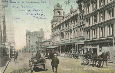
Alice McGREGOR Born: 1908; unknown parents. Possibly adopted by the Salter family? Electoral Roll 1936: Highland Terrace Kangaroo Flat. Alice Mary Salter and William Robert Salter living together; presumed to be sister and brother. William Robert Salter was killed in a MVA in Bendigo in 1937 aged 26. In Victoria in 1938, Alice Mary Salter married James Thomas McGregor (born Victoria 1917, died Victoria 1983, buried Fawkner Cemetery) Lived: 1968; 22 Wade Street Golden Square Alice McGregor Died: 1999 aged 91 at Anne Caudle Centre, Bendigo Buried: Kangaroo Flat Cemetery See additional research. Postcard Album of Alice McGregor contained 86 post cards.Postcard Album of Alice McGregor containing 86 postcards. See 1400 Colour photo of Commissioner St., Johannesburg, S. Africa Horse drawn vehicles, a tram and pedestrians on the street. Addressed to Miss A. Stapleton, Arcade, Bendigo, Victoria, Australia Sender - Miss G Owen, Church Street, Clitenhage (?), S.Africa Dated 8/7/05 postcard, collector, alice mcgregor -
 Ballarat Heritage Services
Document - Report, McDougall and Vines Conservation and Heritage Consultants, Sturt Street Gardens, Ballarat, Victoria Conservation and Landscape Management Plan, 2007, 07/2007
Ballarat's Sturt Street has its origins in W.S. Urquhart's survey of 1851. A generous reserve was allocated for the main streets of Ballarat, of which Sturt Street was the first. In the 1860s Sturt Street was planted with blue gums, with a dual carriageway and central median strip installed. Bandstands ere soone erected, including the Queen Alexandra Bandstand (1908) and the Titanic Memoria Bandsatnd (1915).PDF of a report on the Sturt Street Gardens, Ballarat.sturt street ballarat, conservation management plan, sturt street gardens, landscape management plan, statue, gardens, bandstands, infrastructure, city of ballarat report -
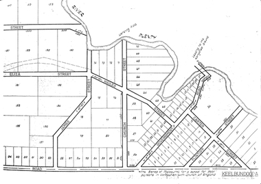
 City of Kingston
Pamphlet - Black and white, J. F. Brady, The Hill Estate, Highett, c. 1905
Sales plan for land in the suburb of Highett, bounded by Sandford Street, Turner Street and Point Nepean RoadThe developing urban area of Highett within the City of Kingston. This land sale pamphlet illustrates the subdivision of land within the municipality and the changing demographic of the district as new houses are constructed close to infrastructure.Black and white pamphlet advertising for sale the Hill Estate, Highett. Incorporates a map of the estate bordered by Sandford Street, Turner Street and Point Nepean Road.Handwritten in grey pencil on reverse: The Hillland sales, highett, estate -
Port Melbourne Historical & Preservation Society
Photograph - Back wall of Milk Bar in Princes Street from 70 Station Street, Port Melbourne, Pat Grainger
225 Princes Street was sold and demolished after its owner, Ted Young, was brutally murdered there (multiple stabbing). Police thought they knew who did it but had no evidence. Wall of Milk Bar across Princes Street was subsequently demolished.One of three colour photos of 225 Princes Street following demolition (2000?): .02 View from 70 Station Street through to Princes Street and back wall of Milk Bar before demolition.Some notes in pencilbuilt environment - domestic, demolitions, crimes and misdemeanours, edward (ted) young -
 Greensborough Historical Society
Photograph - Digital image, Charles Marshall et al, Street scene, Cairo, 1917_
This photograph shows a street scene in Cairo.Digital copy of black and white photograph. "Street scene in Cairo" [rest of caption illegible]charles marshall, world war 1 -
 Greensborough Historical Society
Maps, Greensborough. Parish Plan 1860, 1860c
This plan show Green's subdivision of Greensborough, north of Grimshaw Street.Enlargements of Parish plan circa 1860?One copy possibly from 1860, containing lot numbers for a government road, now Main Street, and surrounding streets.greensborough, grimshaw street greensborough, edward bernard green -
 Tatura Irrigation & Wartime Camps Museum
Photograph, Hogan Street Tatura
Shows businesses along Hogan Street looking west towards Ross Street intersection. Colour photograph showing businesses along Hogan Street, Tatura, looking west towards Ross Street intersection. Photograph stuck onto piece of white cardboard. hogan street tatura, tatura businesses, ross street tatura -
 Port Melbourne Historical & Preservation Society
Photograph - Preparation for Adventure Playground, Nott Street Primary School, 1977
Construction of Adventure Playground Nott Street Primary School. in the background can be seen the former Port Melbourne Picture Theatre at 284 Bay Street. Sign shows that in 1977 it was Dudley Pty Ltd. The building was gutted by fire in 2015. B & W photograph of preparations for an Adventure Playground on the Nott & Farrell Streets corner, Nott Street Primary School 1977education - primary schools, nott street primary school -
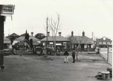
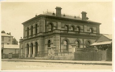 Stawell Historical Society Inc
Postcard - Stawell Court House, Court House in Patrick Street
Court House Patrick Street .PostCard Court House Patrick Street Court House 15stawell building, court house -
 Port Melbourne Historical & Preservation Society
Photograph - YMCA Nott Street 1973, Reverend Donald LANGFORD, June 1973
The Bridge Street Presbyterian Church is on the left of the photograph with numbers to the right - 305, 397 & the YMCA Port Melbourne Youth Centre at 311 - 313.B & W photograph of YMCA Nott Street between Bridge & Spring Streets 1973.June 1973built environment - demolition, built environment - domestic, ymca, religion - presbyterian church, port melbourne youth centre -
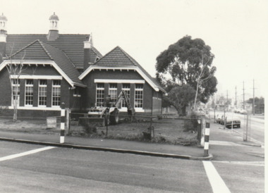
Tatura Irrigation & Wartime Camps Museum
Photograph, Former irrigation Trust Office, 1986
Photograph of 49 Hogan Street Tatura, former Irrigation Trust Office, Doctors residence, Reilly family residence. Being restored as Irrigation and Local History Museumblack and white photograph of building being restored to be used as museum49 Hogan Street 1986irrigation trust office, tatura doctors residence, reilly family residence -
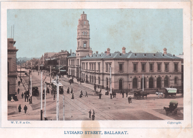 Ballarat Tramway Museum
Photograph - Illustration, WTP, "Lydiard Street Ballarat", c1905
Colour Illustration showing the northeast corner of Sturt and Lydiard Streets, post office, tram track, and one tram partially obscured. Has many people in view and some horse-drawn vehicles. Titled "Lydiard Street and Post Office Ballarat, Victoria". Published by WTP. See item 4376 for the related postcard. Yields information about the post office corner at the time of the opening of the tramway and demonstrates colour printing techniques.Colour Illustration cut from a journalOn rear in pencil - "Looking up Lydiard Street North from Marks Corner (Sturt Street) before 1913tramways, trams, sturt st, esco, post office, lydiard st north -
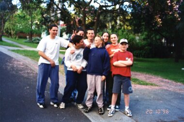 Greensborough Historical Society
Photograph - Photographs, Sue Ballantyne, Willis Street kids 1996, 20/10/1996
Photographs of 8 local children hanging out in Willis Street Greensborough in 1996 during a game of football on the street in the Greenhills estate.Set of 5 colour photographs of teenagers in the streetFirst names of people in photos are written on back of each photographwillis street greensborough, football, greenhills -
 Port Melbourne Historical & Preservation Society
Photograph - Preparation for Adventure Playground, Nott Street Primary School, 1977
Construction of Adventure Playground Nott Street Primary School. B & W photograph of preparations for an Adventure Playground on the Nott & Farrell Streets corner, Nott Street Primary School 1977education - primary schools, nott street primary school -
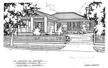 Hawthorn Historical Society
Drawing - Property Illustration, 60 Denham Street, Hawthorn
'After training as a Cartographic Draftsman within the mining industry, I worked as a property illustrator for real estate firms in the eastern suburbs of Melbourne for 23 years from 1983. I initially photographed houses with a Polaroid camera and made a 'thumbnail' sketch while there. The photos were used to scale off a sketch in pencil and then that sketch was overlaid with drafting film and the 'pen and ink' completed. The pens I used were the Rotring ‘Rapidigraph’ drafting pens. The ink was also made by Rotring (German).The film was ‘Rapidraw’, polyester drafting film, double matte. It takes a very fine line and doesn’t bleed. As well as house sketches, there were often floor plans and site plans ordered. Aerial sketches were ordered when the property needed an overall view.' (Margaret Picken, 2020)This property illustration is one of a series created by Margaret Picken for a range of real estate agents in Melbourne between c. 1983 and c. 2006. Each work is signed and dated by the artist.Gift of Margaret Picken, 2020Pen and ink property illustration on drafting film of 60 Denham Street, Hawthorn by Margaret Picken.60 Denham Street, Haw, Margaret Picken '89. Woodards - Hawthorn (note: Orig > Longfords 14-3-90)artist - margaret picken 1950- -
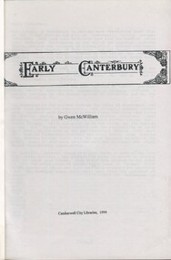 Surrey Hills Historical Society Collection
Book, Early Canterbury, 1994
This booklet gives a brief description of the local settlement in Canterbury giving the landholders names and name of the house (before street numbering was introduced) and street it was located in.This booklet gives a brief description of the local settlement in Canterbury giving the landholders names and name of the house (before street numbering was introduced) and street it was located in.canterbury, (ms) jane f portingale, postmistress, (mr) arundel wrighte, wood brothers, koonung creek, (mr) thomas power, (mr) oliver russell, (mr) frederick griffin, (mr) thomas payne, shrublands, w creek, (mr) john gardiner, (mr) james shanley, (mr)robert hoddle, (mr) michael logan, (mr) patrick moloney, (mr) hugh glass, r. larkins, t. hassett, e. sturt, d.s. campbell, (mr) joseph camm, riversdale road, w. logan, rochester road, 1843, trees, mont albert road, a. sikes, (mr) william smith, 1853, (mr) ernest carter, dentist, elgar's surrey, hindson family, (mr) george granville mercy, (mr) alfred golding, (mr)alexander patterson, (mr) thomas boanas, (mr) thomas hyde, builders, (mr) richard terrill, architects, (mr) thomas miles, drapers -
Port Melbourne Historical & Preservation Society
Document - 2011 Melway Greater Melbourne Street Directory, 2011
... streets ...2011 editions of Melway Greater Melbourne Street Directory Top quarter white, bottom blue background with photo of citybuilt environment, engineering - roads streets lanes and footpaths, natural environment, transport - roads, streets, mapping, greater melbourne -
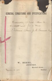 Bendigo Historical Society Inc.
Document - MARKS COLLECTION: EXCAVATING BRICK, STONE CONCRETE WORK BILLIARD ROOM FORTUNA, 12th January, 1893
Document, on top of first page printed General Conditions and specifications' handwritten, for excavating brick, stone and concrete work for a new Billiard Room for G. Lansell Esq' On bottom of page printed : W. Beebe, Architect, Mitchell Street, Bendigo. Dated Jan 12, 1893.W Beebe, Architect, Mitchell Street, Bendigobendigo, buildings, fortuna villa -
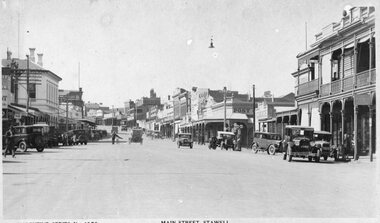 Stawell Historical Society Inc
Photograph, Main Street Stawell looking East from area in front of Town Hall -- Postcard c1930
Valentine Series No 1078 Main Street looking East from area in front of Town Hall c1930 Town Hall Hotel Post Office and Post Office Hotel and Bull and Mouth Hotel are visible. Vehicles in street.Valentine Series No. 1078 Main Street Stawellstawell business streetscape -
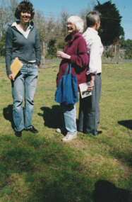 Port Melbourne Historical & Preservation Society
Photograph - Launch of History of a Street Precinct, 25 Sep
In 2005, members of the PMH&PS undertook a study of the residents of the houses in a Port Melbourne street precinct from the 1880s to 1960. The area is bounded by Evans Street, the E side of Bridge Street, S side of Williamstown Road, Farrell Street both the E & W sides plus the section of Ross Street between Farrell and Bridge and the part of Derham Street between Farrell and Bridge. The resulting map and an interactive CD won the Best Community Research, Registers & Records project at the 2007 Victorian Community History Awards. The project was launched on the railway reserve near the corner of Evans & Farrell streets. L- R - Natica SCHROEDER, Pat GRAINGER, Janet BOLITHO.Three members of the PMHPS the launch of the History of a Street Precinct25/9/05 Natica Schroeder, Pat Grainger, Janet Bolithohistory of a street precinct, pat grainger, natica schroeder, janet bolitho -
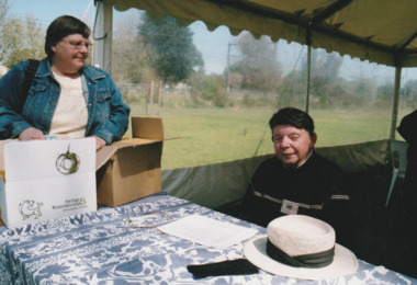 Port Melbourne Historical & Preservation Society
Photograph - Launch of History of a Street Precinct, 25 Sep
In 2005, members of the PMH&PS undertook a study of the residents of the houses in a Port Melbourne street precinct from the 1880s to 1960. The area is bounded by Evans Street, the E side of Bridge Street, S side of Williamstown Road, Farrell Street both the E & W sides plus the section of Ross Street between Farrell and Bridge and the part of Derham Street between Farrell and Bridge. The resulting map and an interactive CD won the Best Community Research, Registers & Records project at the 2007 Victorian Community History Awards. The project was launched on the railway reserve near the corner of Evans & Farrell streets. L- R - Val POWER, Jim POWER.Two members of the PMHPS the launch of the History of a Street Precinct25/9/05 Val Power, Jim Powerhistory of a street precinct, val power, jim power -
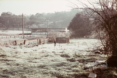 Eltham District Historical Society Inc
Photograph, Russell Yeoman, Frosty morning, 66 Susan Street, Eltham, c.1965, 1965c
... streets ...Now the site of the Eltham Skate Park; Susan Street north of Bridge Street has since been renamed as an extension of Brisbane Street.Digital file only; created from original colour positive slide transparencyeltham, streets, susan street, eltham skate park, russell yeoman collection -
 Mission to Seafarers Victoria
Photograph - Photograph, Black and white, Reverend John Reginald Weller, The Mission from Flinders Street Extension Saturday afternoon, c. 1925
The photograph shows the mission and the weathervane in 1925.The photograph helps dating the installation of the weathervane on the roof that least 1925.Black and white photograph with thin white border depicting the Mission on Flinders Street from a slight angle. The photograph is glued to the photographic album page.Handwritten below in white ink: The Mission from Flinders Street Extension Saturday afternoon717 flinders street, mission to seamen, canopy, weathervane, weller album -
 Greensborough Historical Society
Photograph - Digital image, Charles Marshall et al, Victorian country scene, 1920s
This photograph shows what could be a Victorian country scene. The caption includes a notation "Speight Street Northcote."Digital copy of black and white photograph. "Speight Street Northcote" and other notescharles marshall, world war 1 -
Glenelg Shire Council Cultural Collection
Photograph - Photograph - Julia Street, Portland, 1930s
Black and white photo, white border. View of Julia St. Portland, taken from middle of road, looking west, left hand side, block between Bentinck and Percy Streets. Four cars, 1 motorbike, road not sealed.'JULIA STREET, PORTLAND', black print, lower borderphotography, julia street, portland -
 Marysville & District Historical Society
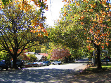
Photograph (Item) - Colour photograph, Unknown
A colour photograph of Murchison Street in Marysville in Victoria.A colour photograph of Murchison Street in Marysville in Victoria.murchison street, marysville, victoria, photograph