Showing 856 items
matching surveyors-terrestrial
-
 Kew Historical Society Inc
Plan - Subdivision Plan, Jas R Mathers Son & McMillan, Macartney Estate, East Kew, c. 1925
Pru Sanderson, in her groundbreaking ‘City of Kew Urban Conservation Study : Volume 2 - Development History’ (1988), summarised the periods of urban development and subdivisions of land in Kew. The periods that she identified included 1845-1880, 1880-1893, 1893-1921, 1921-1933, 1933-1943, and Post-War Development. These periods were selected as they represented periods of rapid growth or decline in urban development. An obvious starting point for Sanderson’s groupings involved population growth and the associated economic cycles. These cycles also highlighted urban expansion onto land that was predominantly rural, although in other cases it represented the decline and breakup of large estates. A number of the plans in the Kew Historical Society’s collection can also be found in other collections, such as those of the State Library of Victoria and the Boroondara Library Service. A number are however unique to the collection.Subdivision plans are historically important documents used as evidence of the growth of suburbs in Australia. They frequently provide information about when the land was sold on which a built structure was subsequently constructed as well as evidence relating to surveyors and real estate and financial agents. The numerous subdivision plans in the Kew Historical Society's collection represent working documents, ranging from the initial sketches made in planning a subdivision to printed plans on which auctioneers or agents listed the prices for which individual lots were sold. In a number of cases, the reverse of a subdivision plan in the collection includes a photograph of a house that was also for sale by the agent. These photographs provide significant heritage information relating house design and decoration, fencing and household gardens.The Macartney Estate subdivision advertised 21 lots for sale on either side of Macartney Street (now Macartney Avenue) and Evans Road in what was then designated as East Kew. Most of the houses shown on the south side of Macartney Street then, as now, have rear entrances on Mount Street, however a number of these blocks have since been further subdivided to allow for the building of new houses on the rear of a block. Brougham Place is marked on the plan but is now called Daniell Place."C"subdivision plans - east kew, macartney estate, macartney street, mount street, evans road, brougham place -
 Stawell Historical Society Inc
Archive, Mining Surveyor’s and Registrar’s Reports 1859-1871, 1859 - 1871
None for year 1867stawell, mining -
Stawell Historical Society Inc
Archive, Mining Surveyor’s and Registrar’s Reports - 1872-1878 not complete, 1872 - 1878
stawell, mining -
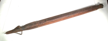
 Port Fairy Historical Society Museum and Archives
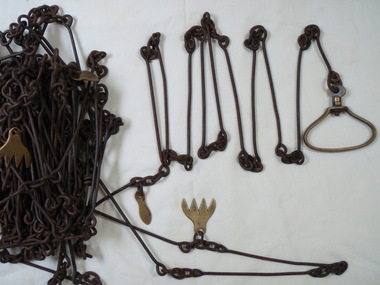
Functional object - survey chain
metal surveying chain with brass markers and handlesJames Beddington "Warranted correct"local history, surveying, terrestrial, survey chain beddington -
University of Melbourne, Burnley Campus Archives
Map (item), Proposed Reserve for Horticultural & Experimental Garden in the Survey Paddock. Clement Hodgkinson Deputy Surveyor General, 1862
horticultural & experimental garden, survey paddock, clement hodgkinson -
Friends of Ballarat Botanical Gardens History Group
Work on paper - North Gardens Wetlands Information Notes, Friends of Ballarat Botanical Gardens (Guiding Friends Group), C 2001
Important information about the North Gardens Wetlands and the primary objective of improving storm water quality.This project was completed in March 2001 and besides its ecological importance, it provides a destination at the northern end of the Gardens, creates social linkages between various environmental groups as well as improving the aesthetic standards of the site.1 page set out with subheadings.Nonenorth gardens, north gardens wetlands, north gardens wetlands project, ballarat botanical gardens, friends of ballarat botanical gardens, john garner, regional indigenous plants, aquatic and terrestrial plants, storm water, john garner collection, gardens, ballarat, garner -
 Mrs Aeneas Gunn Memorial Library
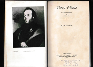
Book, Oxford University Press, Thomas Mitchell, Surveyor General and explorer, 1954
A biography of Thomas Mitchel ; including account of contacts with Aborigines during expeditions.Index, bib, ill, maps, p.270.non-fictionA biography of Thomas Mitchel ; including account of contacts with Aborigines during expeditions. australia - discovery and exploration, thomas mitchell -
 Moorabbin Air Museum
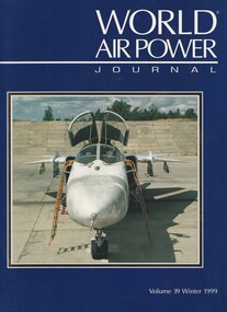
Book (item) - (SP) World Air Power Journal 39 Winter 1999
air power analysis update: bangladesh, austria, briefings: sukhoi su-27kub, ban lanveoc-poulmic aeronavale base, rsingaf in france, saudi cougar csar, atr 42mp surveyor, iran af 75th anniversary feature, mitsubishi f-2 feature, focus aircraft: sukhoi su-24 ‘flanker’ (44 pages), fuerza aerea de el salvador photo feature, news feature: allied force part 2, variant briefing: westland lynx part 1 – army versions, air power analysis: italy -
Port Melbourne Historical & Preservation Society
Plan - Extension to weighbridge, Sandridge, George Kelly?, Borough Surveyor, 8 Nov 1864
Plan for extension of weighbridge, Borough of Sandridge, 1864.Numbered in red pencilengineering, borough of sandridge - engineering department, george kelly -
 Victorian Railway History Library
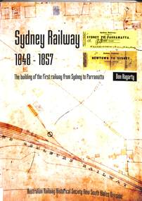
Book, Hagarty, Donald, Sydney Railway 1848-1857, 2005
The known story of the work of six men - a naval surveyor, four engineers, and the contractor who, with many others, built the first railway from Sydney to Parramatta between 1848 and 1857.index, ill, maps, p.464.non-fictionThe known story of the work of six men - a naval surveyor, four engineers, and the contractor who, with many others, built the first railway from Sydney to Parramatta between 1848 and 1857.railroad construction - new south wales - history, railroad operations - new south wales - history -
 Bendigo Historical Society Inc.
Document - LANDS OFFICE: DISTRICT SURVEYORS SANDHURST INDEX OF PLANS, no date probably 19C
Document: dark green hard cover journal with buff spine and corners. Index in front A - Z. 400 pages, pages not indexed but numbered. Index lists places of various districts e.g. Bridgewater on page 7. Plan details give allotments, parish, sections, plan number.Lands Officelands office, index of plans, plans, bendigo -
 Bendigo Historical Society Inc.
Functional object - Surveyor's Trypod
Three pieces of wood with one curved side and two angled sides that come together to form a circular shape. the tops have brass fittings that are attach by hinged mechanisms to a brass plate with a short three centimetre diameter thread on top. At the base of each is a long metal spike with an attachment to push in into the ground.surveying equipment, mapping, wooden trypod -
University of Melbourne, Burnley Campus Archives
Plan, Plan showing land required for Road Purposes from the temporary reservation for Horticultural Gardens at Richmond. John S. Jenkins Town Surveyor Richmond. 1st April 1880, 1880
Framed and glazed copy of B92.0540.gardens, richmond, hoticultural society of victoria -
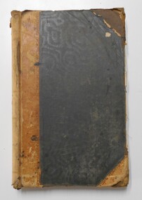
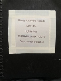 Tarnagulla History Archive
Folio of Extracts of Mining Surveyor's Reports - 1859-1864
-
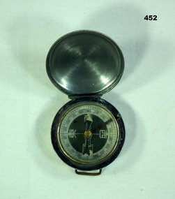 Bendigo Military Museum
Equipment - COMPASS JAPANESE, C. 1939 - 45
Item souvenired by Leslie John Kupke No VX93892 2nd AIF. Refer 2054.2 for his service history. Japanese compass with hinged cover. Casing made of metal. N,S,E,W in Japanese. Case has loops for attaching to a strap.PATEN 2908 stamped on back (worn but visible)surveying-terrestrial, military - equipment, japan -
 National Vietnam Veterans Museum (NVVM)
Equipment - Dumpy level in case
Standard equipment as used by Australian servicemen during the Vietnam conflict. This type of level was first issued for use in WW2.Khaki metal instrument with lens-viewfinder and numbers on circular range finding wheels. Object is stored in a khaki metal box with canvas carry straps. Attachments inside the box prevent it from slipping. Red label attached to strap says the object cannot be repaired.place/date/McBc = GdBg/ McB6 = GdBg/ BuBl COR. Inside box: scientific instruments MFGI and Repair Co. Pty Ltd/ 573 Burwood Road, Hawthorn 815527surveying tool, dumpy level, survey, surveyor, level