Showing 1166 items matching "victoria point"
-
 Federation University Historical Collection
Map - Geological Survey, J. Phillips, Geological Survey of Victoria - Ballarat, 1857, 10/1858
Geological map of the Ballarat District featuring four colours.ballarat, geological, geology, geological plan, main road, camp, golden point, pennyweight hill, clayton hill, ballaarat cemetery, bakery hill, specimen hill, soldiers hill, nightingale lead, native youth black hill flat, white flat, mining, mines, eureka lead, old post office hill -
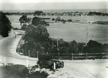
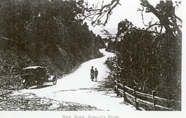 Lakes Entrance Historical Society
Photograph - Princes Highway Lakes Entrance, 1920c
Black and white photograph of the newly formed Princes Highway. It shows the steep cutting into the Jemmys Point hill, the winding road, the post and rail fence, two people and car of the era on road. Lakes Entrance VictoriaNew Road Jemmy's Pointtopography, waterways, roads and streets, fences -
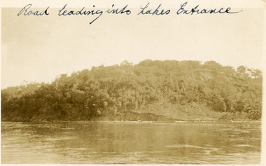 Lakes Entrance Historical Society
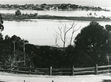
Postcard, 1910c
Faded black and white postcard of Jemmys Point, showing the tree covered hill, road cutting and lake in the foreground. Lakes Entrance VictoriaRoad leading into Lakes Entranceroads and streets, topography -
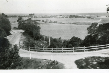
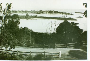 Lakes Entrance Historical Society
Photograph - The Entrance, 1930 c
Black and white photograph of the Princes Highway at Jemmys Point, showing post and rail fence beside road, Bullock Island, the houses of Carpenter town on the southern shore of Cunninghame Arm and Entrance. Lakes Entrance VictoriaLakes Entrance- Gippsland Lakes'coast, fences, roads and streets -
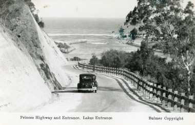 Lakes Entrance Historical Society
Postcard - The Entrance, Bulmer H D, 1930c
Black and copy 9 x 13.5, has inscription 'Princes Highway and Entrance, Lakes Entrance', ink spill on photo top right hand areaTinted small format postcard of the Princes Highway winding around Jemmys Point, between the steep road cutting and post and rail fence, entrance to Gippsland Lakes in the distance. Lakes Entrance Victoria waterways, roads and streets, vehicles -
 Lakes Entrance Historical Society
Photograph - Princes Highway Lakes Entrance, 1930c
Black and white photograph of the Princes Highway as it winds around Jemmys Point. It shows a car parked in foreground, person on bicycle riding up hill, lake, Bullock Island and the township in distance. Lakes Entrance Victoria transport, roads and streets, waterways, township -
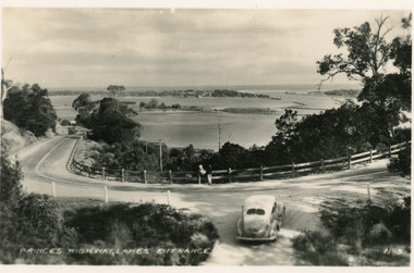 Lakes Entrance Historical Society
Postcard - Princes Highway Kalimna, Valentine Series, 1930c
Black and white postcard of a bend in the Princes Highway as it winds around Jemmys Point, car parked beside highway, two people leaning on post and rail fence, Bullock Island and Lakes Entrance in the distance. Lakes Entrance VictoriaPrinces Highway Lakes Entrancefences, transport, roads and streets -
 Lakes Entrance Historical Society
Postcard, Bulmer H D, 1950c
Also one other postcard same donated by M & V Carpenter in spares box.Black and white postcard of the Princes Highway Jemmys Point, showing Bullock Island between North Arm and Cunninghame Arm, distant view of the entrance from Bass Strait to the Gippsland Lakes. Post and rail fence along roadside. Lakes Entrance VictoriaPrinces Highway and a view of the Entrance vegetation, roads and streets -
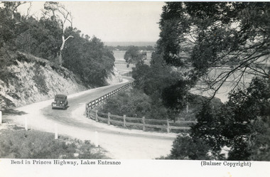 Lakes Entrance Historical Society
Postcard - Princes Highway Kalimna, Bulmer H D, 1935c
Black and white postcard of the Princes Highway as it winds around Jemmys Point. A motor car driving up the hill between steep road cutting and post and rail fence. View of the lake and ocean in the distance. Lakes Entrance VictoriaBend in Princes Highway, Lakes Entrance fences, roads and streets -
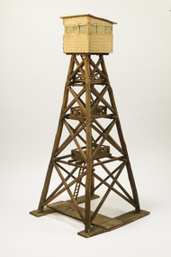 Forests Commission Retired Personnel Association (FCRPA)
Wooden Model Fire Tower, Tom Coish, Model of Reef Hills fire tower, (5 km south of Benalla), 1957
Victoria once had well over one hundred fire lookouts and firetowers. Fire lookouts, or observation posts, were often just a clearing on a hill or a vantage point, whereas firetowers were definite structures. There are at least three categories of firetowers… (1) tree perches, (2) four-legged towers made of either wood or steel, as well as (3) hilltop cabins and observatories. Many were established by the Forests Commission Victoria (FCV) in the 1920s, but the network was expanded rapidly in response to recommendations of the Stretton Royal Commission after the 1939 Black Friday bushfires. The wooden towers were often built by bush craftsmen like legendary FCV overseer Clem Heather from Orbost. But advances in aerial reconnaissance and radio technology led to the gradual reduction in the number of fixed towers. FFMV now operates 72 firetowers. The CFA, Melbourne Water, Hancock Victorian Plantations (HVP) also operate some, the Army has one at Puckapunyal overlooking the live-firing range. Only two remaining fire towers of this design remain in Victoria (Mt Little Dick and Big Tower in the Mullungdung State Forest). Mt Nowa Nowa and Stringers Knob burnt down in the 2019/20 bushfiresLarge model of an Reef Hills fire tower. Presumably used for instructional purposes. Traditional FCV four legged design with three landings and closed cabin.bushfire, forests commission victoria (fcv) -
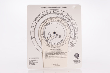 Forests Commission Retired Personnel Association (FCRPA)
McArthur Forest Fire Danger Meter - Mk 5, 1992
The Forest Fire Danger Index (FFDI) was originally invented by the grandfather of Australian bushfire science, Alan Grant McArthur, during the 1950s and ‘60s. Alan published his landmark paper, “Controlled burning in eucalypt forests” in 1962. Leaflet No. 80, as it was known, proved a turning point for forest and fire managers across Australia. More importantly, Alan was very practical forester and wanted his work to be useful to people in the field, so after several iterations he came up with the now familiar circular slide rule called the Forest Fire Danger Meter (FFDM). The Mk 4 version first appeared in operational use in 1967. This is the Mark 5 from 1992Alan McAthur's scientific legacy with the FFDI meter is unquestionably huge and has served forest firefighters very well over the decades.Control burning meter Series of circular slide rules to calculate Forest Fire Danger Index (FFDI)bushfire, forests commission victoria (fcv) -
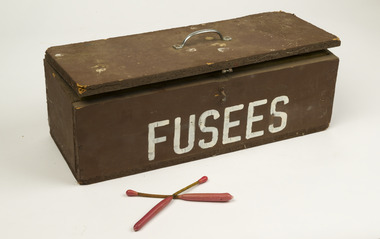 Forests Commission Retired Personnel Association (FCRPA)
Safety box for fusee matches and DAIDS
The Forests Commission developed the use of helicopters for aerial ignition from the mid 1960s. Bryant and May at Richmond worked with the Commission to develop a Delayed Action Incendiary Device. DAIDs as the were known, had an overall length of 180 mm, striker end length - 10 mm. Ignition end length - 80 mm, then a layer of high melting point wax (to prevent accidental ignition when rubbing together in transit). Both ends coated with a modified match head compound with safety fuse exposed length between coated match ends. There was a 17-second delay from when the small end was struck to an intense flaming of the large end, which lasted for 40 seconds. Other types on large matches known as fusees were also used. DAIDs and Fusees were dangerous so were transported in this wooden box lined with foam cushioning. Wooden safety box lined with foam cushion Fuseesbushfire, forests commission victoria (fcv) -
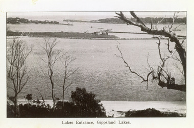
 Lakes Entrance Historical Society
Photograph - The Entrance, 1995c
Second colour copy as 01601-1 portrait size 15 x 10Colour photograph of the entrance from Bass Strait to the Gippsland Lakes. It shows buildings on Bullock Island including Peck's factory. Western end of Bullock Island and area below Jemmys Point, both made during dredging operations over many years. Two fishing boats in entrance. Lakes Entrance Victoria room display, waterways, topography -
 Bendigo Historical Society Inc.
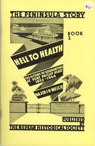
Book - STRAUCH COLLECTION: THE PENINSULA STORY BOOK 2
Victoria's first quarantine station was established at Hobson's Bay in 1840. However with the influx of immigrants during the gold rush, a new station was needed in Port Phillip Bay. In 1852 the "Ticonderago" arrived with 300 passengers ill with scarlet fever and typhus. They were landed at Point Nepean, Portsea, which which was known as the "Sanitary Station" until the 1880's when it's name changed to the Quarantine Station. It ceased quarantine duties in 1980.The Peninsula Story Book 2 Hell to Health the history of quarantine at Port Phillip Heads 1852 - 1966 by Major J.H.Welch, published by the Nepean Historical Society. Soft cover 96 pages with black and white photographs.Major J H Welchvictoria, history, quarantine station, australia-quarantine station-portsea vic-history-victoria -
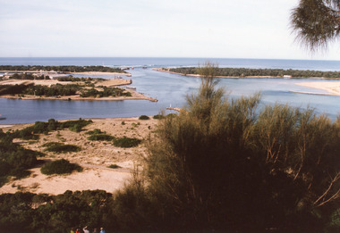
 Lakes Entrance Historical Society
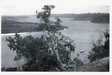
Photograph - Reeves Channel, 1915c
Original in possession of descendant of Arthur Seagrove, teacher at Johnsonville School 1920c.Black and white photograph of Reeves Channel, Gippsland Lakes, showing a launch in the Narrows below Jemmys Point, Rigby Island and a distant view of Fraser Island and Flannagan Island opposite the steep cliffs of the mainland shore. Lakes Entrance Victoria'To Rit with love from Arthur' on backislands, waterways, topography -
 Lakes Entrance Historical Society
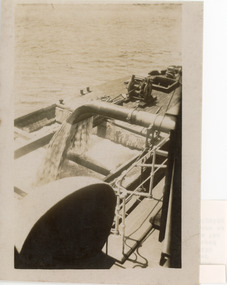
Photograph - Dredging, 1927
... Jemmys Point. Lakes Entrance Victoria... Jemmys Point. Lakes Entrance Victoria Photograph Dredging ...Typed note in album explains how hinged steel doors in the bottom of the barge release the sand.Black and white photograph showing discharge of dredged sand from PWD dredge W H Edgar into her hopper barge, off Jemmys Point. Lakes Entrance Victoriadredging, jetties, ships and shipping, waterways -
 Lakes Entrance Historical Society
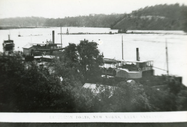
Photograph - New Works Jetty, 1910c
Also second black and white copy 9 x 13 cmBlack and white photograph showing lakes and boats at new Works Wharf. Some groyne work on Bullock Island on right, road cutting on Jemmys Point on right, Kalimna and Nungurner hills in background. Lakes Entrance VictoriaExcursion Boats, New Works Lakes Entrancejetties, waterways, boats and boating, topography -
 Lakes Entrance Historical Society
Photograph - Carpentertown, Silver Reflections Studio, 1924c
... and rail fence along roadway down Jemmys Point. Lakes Entrance... Jemmys Point. Lakes Entrance Victoria Photograph Carpentertown ...Black and white photograph showing view of New Works. Village on dunes at entrance to Gippsland Lakes from ocean - Bass Strait. View shows SS Gippsland at New Works wharf, Cunninghame Arm, part of Bullock Island and mouth of North Arm, post and rail fence along roadway down Jemmys Point. Lakes Entrance Victoriawaterways, islands, settlement -
 Lakes Entrance Historical Society
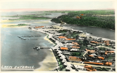
Photograph - Lakes Entrance, 1945c
Two tinted copies, one 8.5 x 13.5 and one 6.5 x 9Black and white postcard showing town, twelve memorial cypress trees and spotting tower on foreshore, post office wharf, boat harbour, Club Hotel at west end of esplanade with five palm trees opposite, causeway to Bullock Island, highway bridge over North Arm, highway up to Jemmys Point, Rigby, Fraser and Flannagan Island's towards Metung. Lakes Entrance VictoriaLakes Entrance islands, aerial photograph, waterways, township -
 Lakes Entrance Historical Society
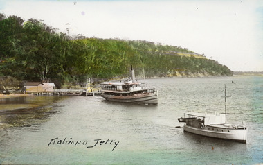
Postcard - Kalimna Jetty, 1925c
Hand coloured postcard showing the S S Gippsland leaving Kalimna Jetty. Jetty has two sheds on north end of jetty belonging to Kalimna Hotel. Navigation light on south end of jetty. M V Sagitassein lower right corner of photo. Jemmys Point in background with road cutting visible. Kalimna Lakes Entrance VictoriaKalimna Jettyships and shipping, waterways, jetties, boating -
 Lakes Entrance Historical Society
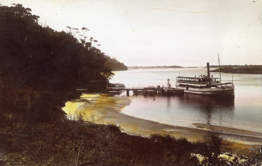
Photograph - S.S. Gippsland, 1925 c
Hand coloured photograph showing S S Gippsland leaving Kalimna Jetty. Small boats tied to far side of jetty, shed at left end of jetty. Jemmys Point beyond Kalimna, hummocks and the entrance in far background, point of Rigby Island on right. Kalimna beach in foreground. Lakes Entrance Victoriaships and shipping, topography, waterways, jetties -
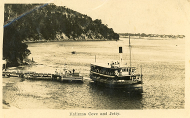 Lakes Entrance Historical Society
Postcard - Kalimna Jetty, 1925 c
Second copy enlarged, black and white 16 x 25 cmBlack and white postcard showing S S Gippsland leaving Kalimna Jetty, Jemmys point in background, hummocks in distance, several people on jetty, small boat in distance, man on rocks fishing. Lakes Entrance VictoriaKalimna Cove and Jettyships and shipping, waterways -
 Lakes Entrance Historical Society
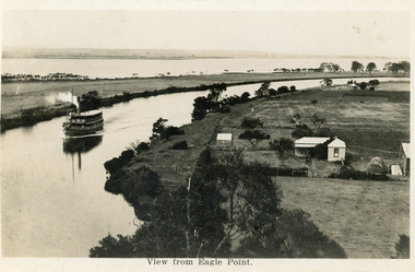
Postcard - Eagle Point, 1930 c
... distance beyond silt jetty, taken from Eagle Point Bluff.... Bairnsdale Victoria Postcard Eagle Point ...Black and white postcard S S Gippsland in Mitchell River, travelling towards Bairnsdale, silt jetties extending eastwards small farm, farm house and sheds on right. Jones bay in Middle distance beyond silt jetty, taken from Eagle Point Bluff. Bairnsdale VictoriaView from Eagle Point. ships and shipping, waterways, agriculture, houses -
 Lakes Entrance Historical Society
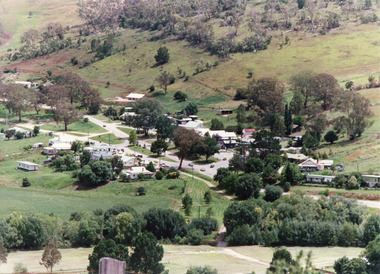
Photograph - Buchan, Tambo Shire, 1994 c
Also second identical copyColour photograph of the township of Buchan, taken from a high point above the town which is situated in a valley with hills rising on all sides. Buchan Victoriatownship, topography -
 Lakes Entrance Historical Society
Photograph - The Entrance, 1995c
Colour photograph of the entrance from Bass Strait to the Gippsland Lakes, it shows the western end of Bullock Island and the built up area below Jemmys Point, both made during dredging operations over many years. Lakes Entrance Victoriaislands, fishing industry, waterways -
 Lakes Entrance Historical Society
Photograph - The Entrance, 1995c
Colour photograph of the entrance from Bass Strait to the Gippsland. It shows the western and of Bullock Island and the built up area below Jemmys Point, all made during dredging operations over many years. Lakes Entrance Victoriafishing industry, islands, waterways -
 Lakes Entrance Historical Society
Photograph - The Entrance, 1922c
... boxes, rock groynes, and sandy shore beneath Jemmys Point. Lakes..., and sandy shore beneath Jemmys Point. Lakes Entrance Victoria ...Black and white copy 9.5 x 15|Black and white copy 12x18Black and white photograph of the entrance and Bullock Island. It shows the western end of Bullock Island with bathing boxes, rock groynes, and sandy shore beneath Jemmys Point. Lakes Entrance VictoriaLakes Entrance, Gippsland Lakesislands, waterways, topography -
 Lakes Entrance Historical Society
Photograph - The Entrance, 1930c
Black and white photograph showing wooden piers at entrance to Bass Strait from the Gippsland Lakes. Buildings on sand dunes, Bullock Island and rock groynes. Photo taken from Jemmys Point showing shrubbery in foreground. Lakes Entrance Victoriawaterways, topography, boats and boating, islands -
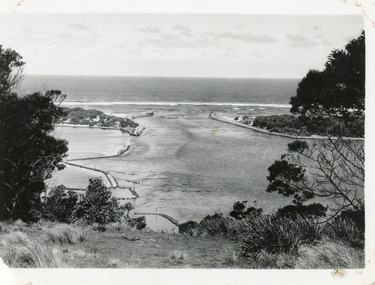
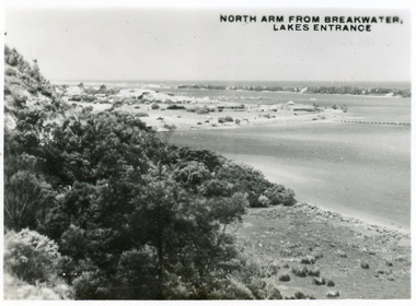 Lakes Entrance Historical Society
Postcard - North Arm Lakes Entrance, 1945c
One other copy same sizeBlack and white small format postcard of the entry to the North Arm, taken from Jemmys Point. It shows a steep cliffside above the calm waters, township of Lakes Entrance and Cunninghame Arm, and sand hummocks of southern shore in distance. Lakes Entrance VictoriaNorth Arm from Breakwater - Lakes Entrancetownship, waterways, topography -
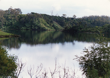 Lakes Entrance Historical Society
Photograph - North Arm, Tambo Shire, 1990c
Second copy image identical 20.5 x 28.5Colour photograph of a bay in the North Arm. It shows the calm waters of the lake surrounded by steep wooded banks, a grassy point with remains of fence or jetty. Reflections of surrounding vegetation in water. Lakes Entrance Victoria waterways, topography