Showing 4308 items matching "westerns"
-
 Stawell Historical Society Inc
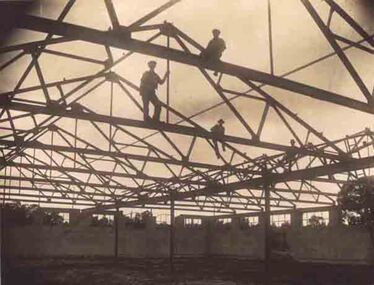
Photograph, North Western Woollen Mills during Construction
North Western Woollen Mills - Roof Constructionstawell industry -
 Stawell Historical Society Inc
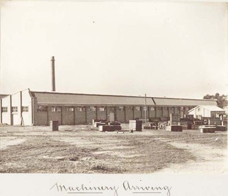
Photograph, North Western Woollen Mills with Machinery Arriving
North Western Woollen Mills - Machinery Arrivingstawell industry -
 Stawell Historical Society Inc
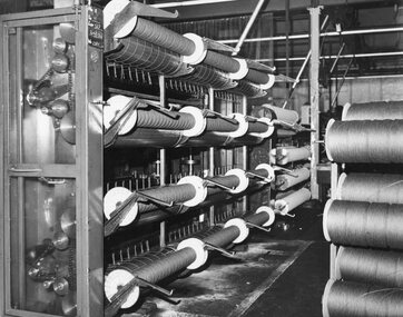
Photograph, North Western Woollen Mills -- Carding Machines
North Western Woollen Mills - Carding Machinesstawell industry -
 Stawell Historical Society Inc
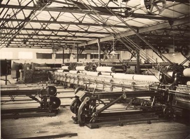
Photograph, North Western Woollen Mills -- Spinning Machines
North Western Woollen Mills - Spinning Departmentstawell industry -
 Stawell Historical Society Inc
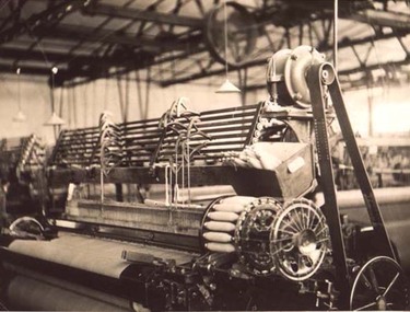
Photograph, North Western Woollen Mills featuring a Northrop Loom
North Western Woollen Mills Northrop Loomstawell industry -
 Stawell Historical Society Inc
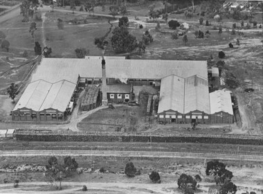
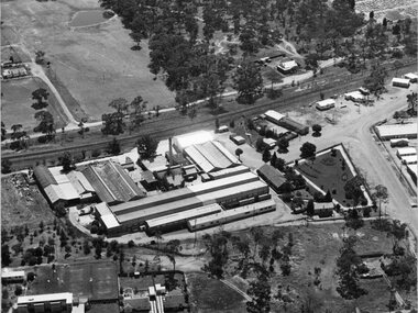
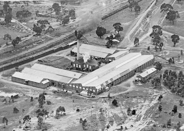
Photograph, North Western Woollen Mills -- Aerial View, Duplicate of Framed Image
North Western Woollen Mills Aerial Viewstawell industry -
 Stawell Historical Society Inc
Photograph, North Western Woollen Mills -- Aerial View, Duplicate of Framed Image
North Western Woollen Mills Aerial ViewUnframed Copystawell industry -
 Stawell Historical Society Inc
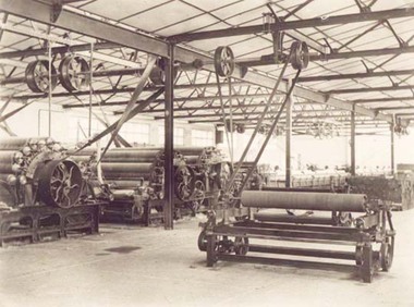
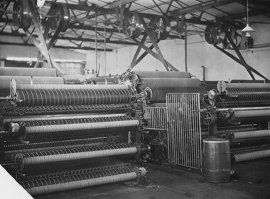
Photograph, North Western Woollen Mills -- Carding Plant
North Western Woollen Mills Carding Plantstawell industry -
 Stawell Historical Society Inc
Photograph, North Western Woollen Mills -- Carding Plant
North Western Woollen Mills Carding Plantstawell industry -
 Stawell Historical Society Inc
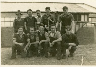
Photograph, North Western Woollen Mills -- Staff 1940
North Western Woollen Mills Staff 1940stawell industry -
 Stawell Historical Society Inc
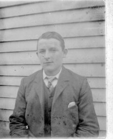
Photograph, "Glisson" Family from Great Western
Glisson family Great Western. Portrait of male.stawell -
 Stawell Historical Society Inc
Photograph, "Glisson" Family from Great Western
Glisson family Great Western. Portrait of male.stawell -
 Stawell Historical Society Inc
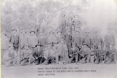
Photograph, Great Western Rifle Club Members 1903 -- 2 Photos
Great Western Rifle Club Members 1903stawell sport -
 Stawell Historical Society Inc
Photograph, Great Western’s first Primary School 1998 -- Coloured
Great Western’s first Primary School 1998stawell education -
 Stawell Historical Society Inc
Book, Greg Cameron, Western Mining Corporation's Attempt To Re-Open the Magdala Shaft 1986, 2005
Western mining attempted opening of the Magdala Shaft Black Plastic covers with green plastic ring spine.stawell gold mining -
 Stawell Historical Society Inc
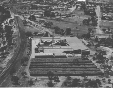
Photograph, North Western Woollen Mills -- Aerial View
North Western Woollen Mills Aerial Viewstawell industry -
 Stawell Historical Society Inc
Photograph, North Western Woollen Mills -- Aerial View
North Western Woollen Mills Aerial Viewstawell industry -
 Bendigo Historical Society Inc.
Letter - KANGAROO FLAT GOLD MINE COLLECTION: WESTERN MINING CORPORATION TO J.O. REYNOLDS, 11th June 1980
Letter addressed to D. McClure, M.L.A., June 11th, 1980 from Western Mining Corporation Limted. Letter outlines the plan to 'use a commercial elevator rather than a winding system for placing tourists into the underground exhibition'. Western Mining Corporation intended to make a donation to fund this venture but 'the money involved is rather more than we had in mind'. The original quote was $45,000 but is going to be in the range of $200,000 to $300,000. A two page file note on a telephone conversation between Daryl McClure and J.O. Reynolds of WMC re the Central Deborah Gold Mine is appended to the letter.bendigo, gold mining, central deborah gold mine, bendigo, central deborah gold mine, gold mining, western mining corporation, daryl mcclure, j. reynolds, arvi parbo. -
 Ballarat Tramway Museum
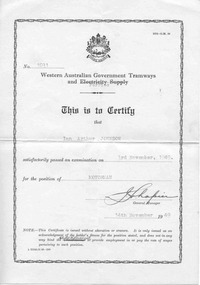
Certificate, Western Australian Government Tramways and Ferries
Two certificates issues by the Western Australian Government Tramways and Ferries to a tram driver and a trolley bus driver. 4287.1 - Certificate No. 1031, originally printed for the Western Australian Government Tramways and Electricity Supply, but overtyped with the word "Ferries", issued to Ian Arthur Johnson for the position of Motorman on 3/11/1949 and signed by the General Manager. The word commissioner has been crossed out and replaced in ink "General Manger" 4287.2 - as above, certificate No. 1219, newer printed certificate for the WAGT&F, for Ian Arthur Hensworth Johnson, dated 29/5/1951 as a trolley bus driver. tramways, trams, perth, trolley buses, motormen, certificates -
 Bendigo Historical Society Inc.
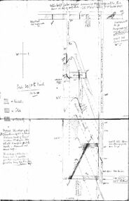
Document - CHRISTMAS REEF GOLD MINING CO. COLLECTION: PLAN OF MINE
Hand drawn plan of mine, showing spurs, slate, lava. Christmas Reef shaft and Great Western shaft drawn. Notations in pencil. On left hand side 'Memo: the shaft of the Christmas Reef Co is about 5 chains north of Great Western Cos shaft. The strata and surface pitch north, assumed at same rate. The working of Allingham and Moore's Trib Co are taken from their reports in Bendigo Advertiser May 1872 to May 1873. Jas Down Mgr' Scale on plan 20 ft to 1 inch Legend shows sandstone, slate and quartz.Bendigo Advertiserbendigo, mining, christmas reef gold mining -
 Bendigo Military Museum
Memorabilia - PHOTOGRAPH, FRAMED
LT COL BENJAMIN THOMAS ROY CHADD No's 10594, VX20311, 1st & 2nd AIF. Refer 2039 for Service History also 2034P. Photograph, framed 'The Beer Sign' Western Desert 1941 re LT COL BENJAMIN THOMAS ROY CHADD VX20311. Tan wooden frame, glass front, cardboard backing, dark green border around photo. Description of photo typed below it.Stamped on rear: Bethany Gallery, 116 Bridge St, Bgophotography - photographs, frame accessories, military history - army -
Glenelg Shire Council Cultural Collection
Souvenir - Bumper Sticker - McDonald's & Mix FM, n.d
Oblong bumper sticker, Left hand quarter black with yellow McDonald's arches and 'i'm lovin' it' in white print. Other ¾ sticker white with red and black print and blue horizontal lines and red Southern Cross; '88.9 MIXX FM Western Victoria'.souvenir, sticker, car accessory -
 Federation University Historical Collection
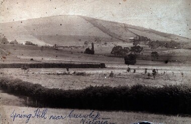
Photograph (Black & White), Spring Hill Near Creswick
Both images are associated with Ellie Campbell. James and Bridget Martin were early settlers at Spring Hill. All their children attended the Ballarat School of Mines..1) A black and white image of Spring Hill near Creswick, glued into a thick card with a gold gilt edge. .2) Martin family house at Subiaco Hill, Western Australia. Brick house built by Corby Statford Cambell, Elly Campbell's father. .1) Written in blue pen on front of photograph 'Spring Hill near Creswick - Victoria' Taped onto back 'Farmland allotted to James George Martin in c1849. He took his bride, Bridget Hyde (19 years old) by bullock dray from St James Church, Elizabeth Street, Melbourne to this new allotment - 10 children born there - William, Robert, Samuel, Elizabeth, Ellen, Emily, Mary (died 2 months old mother also died). J.G.M. moved to Ballarat - attended Dawson Street Baptist Church. Here he married a widow with 2 sons, Mrs ____. Her 2 sons were born, George and Charles (was in USA) . Children all attended School of Mines, Ballarat .2) On yellow sticky label with photo - "Family home Subiace Rd Subiac WA. Builtby Statford Campbell, Elly's fayher. Now Coppin St.ballarat school of mines, william martin, james martin, bridget martin, bridget hyde, samuel martin, elizabeth martin, ellen martin, mary martin, george martin, charles martin -
 Bendigo Historical Society Inc.
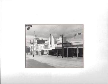
Photograph - VIEW STREET, BENDIGO, 1963 ?
Black and white photograph of western aspect of View Street, Bendigo, showing tramway to Eaglehawk, T. & G. insurance building, National Mutual, printery, fire hydrant. A. Doney is hand written in grey lead at lower right corner . On back of mount '38'A. Doneyplace, streetscape, view street -
Port Melbourne Historical & Preservation Society
Photograph - President, Glen Cosham, displays gift from City of Port Phillip Curator, Joan Winter, PMHPS AGM, Gina Kowalski, Aug 1996
One of ten standard colour photos taken during 1996 Annual General Meeting of the PMH&PS - President Glen Cosham shows framed photo of the lagoon and western jetty presented to the Society by Joan Winter, curator of the City of Port Phillip collectionsocieties clubs unions and other organisations, liana thompson, mayors, don taggart, noel turnbull, jenny turnbull, ingeborg mccullough, denys mccullough, anne callaghan -
 Hume City Civic Collection
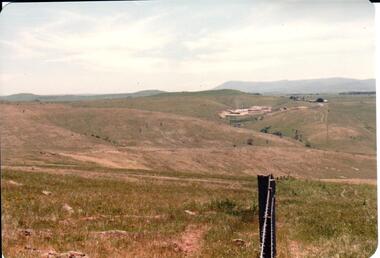
Photograph, early 1980s
The Sunbury Tip was transferred from the end of Reservoir Road as housing development spread in that area to a site on the NW side of Mt. Holden near Riddell Road in the early 1980s.A landscape coloured photograph with rounded corners. It is a panoramic view of open country NW of Sunbury near Riddell Road. There is a fence post with barbed wire hanging from it in the immediate foreground and Macedon Ranges and part of the Western Highlands can be seen across the skyline.macedon ranges, mt. macedon, camel's hump, sunbury municipal tip, george evans collection -
 Stawell Historical Society Inc
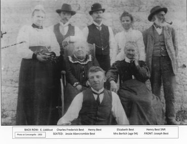
Photograph, Best Family Concongella Vineyard 1903
Sepia Photo - of the Best family and others at Concongella Vineyard, Great Western 1903 Back E Liddicutt, Charles Frederick Best, Elizabeth Best, Henry Best Snr. Seated Jessica Abercrombie Best, Mrs Berlich (94) Front Joseph Best -
 Ballarat Tramway Museum
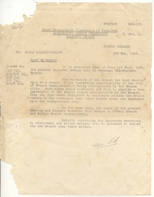
Administrative record - Memorandum, State Electricity Commission of Victoria (SECV), "Name of Branch", 3/05/1966 12:00:00 AM
Yields information about the change of the name of the Ballarat and other SEC branches and how it was done., Yields information about the change of the name of the Ballarat and other SEC branches and how it was done.Duplicated notice on quarto paper about the change of name of the Ballarat Branch to the Mid-Western Branch, effective 1/7/1966. Notice signed by the Branch Manager 3/5/1966. Also noted the change of Geelong to Barwon and Mildura to Mallee branch.trams, tramways, workshops, ballarat, crews, depot -
 Otway Districts Historical Society
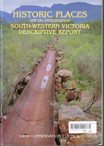
Book, Land Conservation Council, Historic places: Special investigation: South-Western Victoria: Descriptive report, January 1996
The south-west of Victoria, possessing a rich heritage of the signs of past human activity, is fertile ground for an investigation of historic places on public land. This report includes an initial inventory of almost 2000 places. The report outlines the history and the related heritage of the area, describes in some detail its biophysical attributes and introduces the natural resources and present land use. This information provides a context for understanding the origins of the historical features that are observes today.Historic places: Special investigation: South-Western Victoria: Descriptive report. Land Conservation Council. Land Conservation Council; Melbourne (Vic); January 1966. viii, 180 p.; illus.; maps. Soft cover. ISBN 0 7241 9288 3Maps in plastic sleeve.land conservation council; conservation; south-western victoria; historic places; -
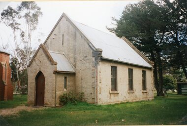
 Kew Historical Society Inc
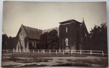
Postcard, Holy Trinity Church, 1905-1913
Holy Trinity Anglican Church is one of the parishes of the Diocese of Melbourne in the Anglican Church of Australia. Services of worship began in this building in March, 1863. The Vicarage was built in 1873, and both carry National Heritage classifications. The church contains many stained glass windows dating from the 19th century.Monochrome postcard showing the exterior of Holy Trinity Church, High Street, Kew. The western exterior of the church is viewed from High Street, Kew. The Church is surrounded by extensive vegetation, some later removed. The postcard predates 1913 when the tower was completed."Reg-No-KHS-411. Holy Trinity Church Kew - Prior to tower completion (1913)"holy trinity church -- kew (vic.), churches -- kew (vic.), postcards -- kew (vic.), postcards -- churches (vic.)