Showing 32049 items
matching buildings
-
 Bendigo Historical Society Inc.
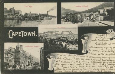
Postcard - GLADYS DEAN COLLECTION: POSTCARD, 1906 - 1908
Printed black and white postcard. Images depict various views of Capetown. Clockwise from upper left is of a jetty with boats and buildings with the words The Jetty printed in red across the top. Next is a streetscape with buildings and trees with the words Tambours Kloof printed in red across the top. Next is an aerial view of a sea port with the words The Docks printed in red across the top. Finally a streetscape with buildings, horse drawn vehicles and people walking with the words Adderley Street printed in red across the top. The words Cape Town are printed in White on the left hand side. A white space depicted as a scroll is in the lower right hand corner containing handwriting. On reverse card is addressed to Mr G Balsillie Hopper St Bendigo Victoria Australia. Writing covers the left hand side.postcard -
 Bendigo Historical Society Inc.
Newspaper - THREE UNRELATED ADVERTISER ARTICLES: SIMES (SYMES?) FAMILY: GOLDEN SQUARE RAILWAY STATION: ONE TREE HILL, 01/09/1984
Three unrelated Advertiser articles all dated 1/9/1984 stapled together- Simes (Symes?)family; Golden Square railway station; One Tree Hill. Simes family: Letter asking for help in assistance with information about the Simes family (1905-1924); Golden Square (railway) station buildings - some history of the building but article is about dilemma of old and 'not needed' buildings ''I wonder whether anybody want Golden Square/'' author - Andrew Ward, Bendigo Advertiser; article by John Hattam re the origin of the name ''One Tree Hill'' and history of the cutting down of The Tree (1879 - prosecution of a Jerry Ryan for vandalism); the road to the top being constructed (1892); lookout-tower constructions - the first being in 1894.document, newspaper, old rail stations, golden square rail station -
 Kew Historical Society Inc
Photograph, J F C Farquhar, Wellington Street From High Street, 1891
At the beginning of the 1890s, the Kew businessman and Town Councillor, Henry Kellett, commissioned J.F.C. Farquhar to photograph scenes of Kew. These scenes included panoramas as well as pastoral scenes. The resulting set of twelve photographs was assembled in an album, Kew Where We Live, from which customers could select images for purchase.The preamble to the album describes that the photographs used the ‘argentic bromide’ process, now more commonly known as the gelatine silver process. This form of dry plate photography allowed for the negatives to be kept for weeks before processing, hence its value in landscape photography. The resulting images were considered to be finely grained and everlasting. Evidence of the success of Henry Kellett’s venture can be seen today, in that some of the photographs are held in national collections.It is believed that the Kew Historical Society’s copy of the Kellett album is unique and that the photographs in the book were the first copies taken from the original plates. It is the first and most important series of images produced about Kew. The individual images have proved essential in identifying buildings and places of heritage value in the district.Very few of the natural or built features in this panoramic photograph of Wellington Street remain. The open land between High Street South and Denmark Street, then known as O’Shannessy’s Paddock, was to become a residential subdivision at the beginning of the 20th Century. On the far side of Denmark Street, bordered by a picket fence, is the Kew Railway Station (demolished 1957). Further east, the large building with the flagpole is the Kew Recreation Hall (demolished 1960), which was the centre of civic life for almost a century. The building was used for dances, civic functions and exhibitions. A bowling green, tennis courts, and a cricket ground surrounded the Hall. The dominant building in the photograph is Xavier College, founded in 1872 by the Society of Jesus. The first classes for pupils were held in 1878. It is presumed that Farquhar used its roof for two of his bird’s eye views.Wellington Street from High Streetkew illustrated, kew where we live, photographic books, henry kellett -
 Glenelg Shire Council Cultural Collection
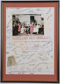
Poster - Poster - Portland Bay Swells, c. 1983
From Portland Town Council Art Programme. Sponsored by PTC's Art Program, the Theatre Board of the Australian Council, Portland 150th Anniversary Committee, Portland CEMA and the Myer Foundation.Poster for theatrical production. The central image is a retouched photograph of a group of people (men and women) outside a building. The building is made of wood. The people are standing in front of the building and on its roofless verandah. They are dressed in clothing of c1910's. The image is black and white with some items of clothing hand coloured in with red, orange and yellow. The entire poster is covered with approximately 61 signatures. On lower left is a reproduced newspaper clipping of paper addressing a welcome home ceremony for Gallipoli soldiers. In pale yellow in background is a map of Portland Bay. In orange mount in black and gold frame. Below image are the words: "Portland Bay Swells! Devised by Ken Harper and the Portland Community." Below this are details of performance times and ticket details. Mounted in peach matt. Black wooden frame with glass.Front: (no inscriptions) Back: (no inscriptions) -
 Bendigo Historical Society Inc.
Newspaper - LONG GULLY HISTORY GROUP COLLECTION: E BRYANT - GROCER
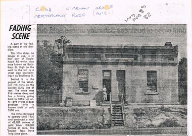
BHS CollectionCopy of a newspaper article titled Fading Scene. Photo shows a building with a stairway leading down to the road in front of it and a lady standing in the doorway. One window has Cash Store printed on it and there are two placards leaning on the building to the left of the lady. Each side of the building are shrubs and picket fence. In the background to the left is the poppet of the Windmill Hill Mine on the Garden Gully line of reef. It is in that part of Eaglehawk Rd which was once known as Backhaus St. High on the wall to the left is a street sign proclaiming it as Backhaus St. Written above the photo is C-sh, E Bryant, Gro-er (there are holes through the words), Perseverance Reef (Hotel). Wed Feb 3rd 82. Article is mounted on yellow card which is mounted on purple card and laminated.bendigo, history, long gully history group, the long gully history group - e bryant - grocer, windmill hill mine, garden gully line of reef, e bryant, perservance reef (hotel) -
 Bendigo Historical Society Inc.
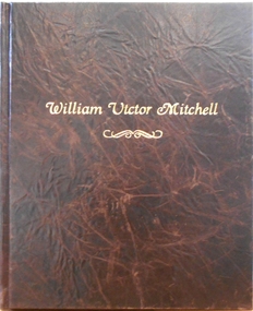
Album - Tui Mitchell Collection: Album of Photographs, William Victor Mitchell "History of Architecture"
William (Bill) Victor Mitchell was a well known Bendigo Architect. He died on August 7, 2010 and is buried in the Bendigo Lawn Cemetery.Brown leather covered professionally bound album containing photographs of Bendigo buildings designed by Bendigo architect William (Bill) Victor Mitchell. Includes thirty black card pages with rice paper interleaves. The first page has a black and white photograph of Bill Mitchell. This is followed by thirty five photographs and two floor plans of buildings designed by Mitchell. Each photograph is double mounted on white and silver card. Name labels are included on each page on white card mounted on silver card. These are followed by nine pages listing 249 buildings, extensions. renovations and projects completed by Bill Mitchell. The final page has a photograph of Bill Mitchell. The album is stored in a custom made lidded black box. The album was produced by SB Libris Bookbinder & Stationer. Bound in Bendigo.Label inside back cover "LIBRIS" Bound in Bendigotui mitchell collection, architect, architecture, bill mitchell, bendigo architecture -
 Melbourne Tram Museum
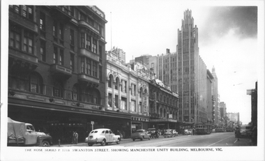
Postcard, Rose Stereograph Co, "Swanston Street, showing Manchester Unity Building, Melbourne", late 1940s
Rose Series postcard No. P 1718, titled "Swanston Street, showing Manchester Unity Building, Melbourne", Photo looking north along Swanston Street from Flinders Lane. Has a one W2 class, one W5 class and one W4 class tramcar in view. The Manchester Unity Building, Capital Theater and the Century Building all dominate the streetscape between Collins and Little Collins Streets. The Champion Building on left of the photo was built around 1923 and demolished around 1972. Yields information about an aerial view of Melbourne late 1930sPostcard - printed real photograph with Rose Stereograph Co. name on the rear.tramways, trams, swanston st, manchester unity building, w2 class, w5 class, w4 class -
 Ringwood and District Historical Society
Photograph, Ringwood Reserve. Looking to SE Corner and Dickins Store, mid 1960's
3 copies of same photo. Written on backing sheet of one, "Ringwood Reserve. SE corner, 1962". On another "Ringwood Reserve Looking South 1966". On Another: "NBE Corner Rwd Reserve. Building on Right is "Dickins" Facing Melb St. " 1962 -
 Ringwood and District Historical Society
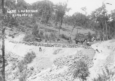
Photograph, Building the recreational man-made lake on the north side of Loughnans Hill: "Lake Loughnan". (Undated)
Printed on photo "Lake Loughnan Ringwood"Typed below photograph, "Building the recreational man-made lake on the north side of Loughnans Hill. It was the local swimming hole in Werac Drive gully beyond Kubis Drive. Now site of a new housing estate." Written on Photo "Lake Loughnan Ringwood" -
 Ringwood and District Historical Society
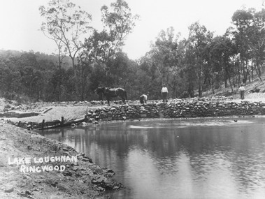
Photograph, Building the recreational man-made lake on the north side of Loughnans Hill
Typed below photograph, "Building the recreational man-made lake on the north side of Loughnans Hill. It was the local swimming hole in Werac Drive gully beyond Kubis Drive. Now site of a new housing estate". Written on photo: Lake Loughnan Ringwood -
 Williamstown High School
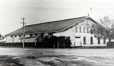
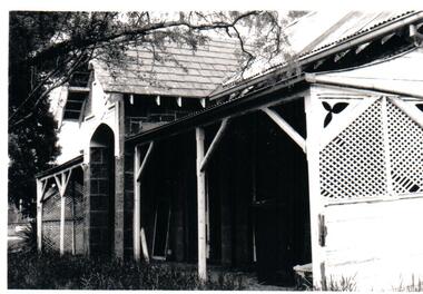
Old Naval Drill Hall
Copy of black and white photograph mounted on board. Accompanied by a captionCaption reads: The Old Naval Drill Hall Assemblies, physical education, social occasions and fund-raising activities happened in this old hall. Some other buildings on the site were used for classrooms and examination areas when there was no space left on the school site.drill hall, williamstown high school, 1960s -
 Dandenong/Cranbourne RSL Sub Branch
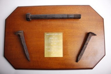
Souvenir - Burma Rail Bridge Bolt & Railway Spikes.On wooden plaque
Plaque with metal railway bridge bolt and 2 metal railway line spikes.Spikes have lip on top to hold rail lines down with chisel shaped ends to by driven into sleepers. Metal bolt used to hold railway sleepers to bridgesNo markings on spikes or bolt. Plaque brass plate engraved-: BURMA RAILWAY BRIDGE BOLT & RAILWAY SPIKES Recovered 1987 By Ex P.O.W V.X. 30397 BILL TOON Approximatly 7,000 Australians Lost Their Lives Building This Railway Line 1942-1945. -
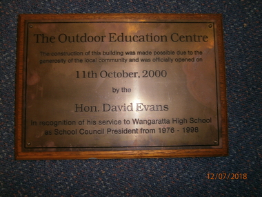 Wangaratta High School
WHS Building Opening Plaque, 2000
Rectangular wooden plaque with a bronze metal plate on the front and black engraved text reading:The Outdoor Education Centre The construction of this building was made possible due to the generosity of the local community and was officially opened on 11th October, 2000 by the Hon. David Evans In recognition of his service to the Wangaratta High School as School Council President from 1976-1998 -
 Ringwood and District Historical Society
Photograph, Maroondah Highway Central, Ringwood. Bamford's Timber Yard, c.1915
Black and white photograph (3 copies- 1 large, 2 smaller) Typed below large photograph: "Bamford's Timber Yard. Cnr. Warrandyte and Main Rds. (Later to become Safeway Site). c1915". Image shows men standing outside building. Timber stacked to left and utility vehicle with P. Bamford written on cabin. -
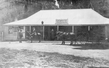 Kiewa Valley Historical Society
Photo - Lagoon Hotel Kiewa - C.A. White
Kiewa is a country town located on the Kiewa River. The hotel was built to supply the local people and those beyond with goods. The hotel continued operating until the 1970s.The town, Kiewa, is in the Kiewa Vally. Lawson's store was a busy place in the 1860s supplying goods to settlements up the river valleys. The Kiewa Post Office opened in 1871. Both businesses continued to operate as the town grew, the post office still providing a service to the local community.Black and white photo of C. A. White's Lagoon Hotel next to the Kiewa Post Office. This photo is published on pages 41 and 42 of 'A History of the Kiewa Valley' by Esther Temple and David LloydOn the back 'From Mrs E. Temple ' Tangambalanga 3691 / President of Kiewa Valley Historical Society' And below - 'Lagoon Hotel, Kiewa / Built by James Lawson 1860 / Post Office opened March 1871 / Building destroyed by fire Jan. 21st 1971'kiewa town, lagoon hotel, kiewa post office, james lawson -
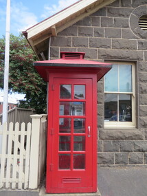 Ballarat Heritage Services
Photograph - Photograph - Colour, Clare Gervasoni, Koroit Post Office, 2015, 21/12/2015
The town borrows its name from the Koroitch Gundidj people who occupied the area prior to European settlement. (https://en.wikipedia.org/wiki/Koroit, accessed 21 December 2016) Koroit was first surveyed as a township in 1847. Around the 1850 the district had the highest population of Irish immigrants in rural Australia. The Koroit Post Office was designed by architect and engineer John Mason of Port Fairy. (Moyne Shire Heritage Study 2006 Stage 2, Volume 2: Environmental History, Prepared for Moyne Shire Council Helen Doyle in association with Context Pty Ltd, 2006.) Rosebrook Bridge, Rosebrook (1853; replaced) Post Office buildings, Bank Street, Port Fairy (c.1857) The author Henry Handel Richardson lived in the Koroit Post Office as a child after her family moved to Koroit in 1878. Remembering Koroit from her youth, the third volume in her The Fortunes of Richard Mahony trilogy is set in the town. When the author was six, her father Walter died in Koroit on 1 August 1879 and was buried at the Koroit cemetery. (https://en.wikipedia.org/wiki/Koroit, accessed 21 December 2016) In 1878 Mary Richardson was appointed postmistress of the Koroit Post Office at a salary of 72 pounds with free quarters, firewood and kerosene. She lived at the back of the Post Office. (From a Green and Pleasant Land by H. McCorkell and P. Yule.) Photographs showing the bluestone Koroit Post Office, phone box and postbox. It is located at 99 Commercial Road, Koroit. "Historic Area Statement of Significance: The significance of Koroit derives from its role as the urban centre of one of the most concentrated Irish Roman Catholic rural districts in Australia, noted for its mixed livestock and cropping argicultural patterns. This is reflected in two separate and distinctive areas in the town - the administrative/commercial area and the church precinct. The administrative and commercial area (focussing on the Boundary-Commercial Road/High Street intersection and the Koroit Hotel) consists of a number of significant public buildings and leads to a street of relatively intact humble shopfronts and kerbline verandahs, visually punctuated by opposing bank facades. The church precinct is dominated by a group of Catholic buildings larger in scale and more complete in range than those in any comparably sized Victorian town." http://vhd.heritagecouncil.vic.gov.au/places/69338#sthash.ELLuSMvg.dpuf, accessed 21 December 2016."koroit, post office, phone box, payphone, bluestone, henry handel richardson, koroit post office -
 Greensborough Historical Society
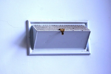
Photograph - Digital image, Dennis Ward, Greensborough Primary School Gr2062 Old Building Interior Air Vent, 25/06/2015
The old brick building at Greensborough Primary School on Grimshaw Street. Built in 1879, this building is now heritage listed by the National Trust. This photograph shows an interior air vent.Digital copy of colour photographgreensborough primary school, greensborough state school -
 Hume City Civic Collection
Photograph
The Bulla Presbyterian Church and Manse were designed by Thomas Taylor. The buildings are of historical significance because they are examples of some of the earliest buildings erected outside Melbourne and still in use.A black and white photograph of the front view of the Manse at the former Bulla Presbyterian Church, now the Uniting Church. The Photograph shows detail of the end wooden trellis walls and wooden poles supporting the verandah.presbyterian church, uniting church, manses, taylor, thomas, george evans collection -
 City of Ballarat Libraries
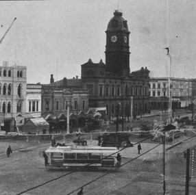
Photograph - Card Box Photographs, View south west along Sturt Street, Ballarat circa 1905. From Star 1855-1905 Jubilee publication
Photo was taken from the Ballarat Post Office tower. The National Mutual Building is under construction. Sign on building reads 'H.M. Theatre Farewell Concert Jessie Maclachlan'.sturt street, ballarat post office, national mutual building, h.m. theatre, streetscape, garden, trams, vehicle, commerical, public -
 Robin Boyd Foundation
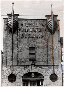
Photograph
The Wharf Labourers building (1915-16), by architect Robert Joseph Haddon was at 480 Flinders Lane. The copper features on the were given to Robin Boyd when the building was demolished.Black and white photographwharf labourers building, robin boyd -
 Royal District Nursing Service (now known as Bolton Clarke)
Photograph - Photograph, black and white, Barry Sutton, 22.06.1977
Royal District Nursing Service (RDNS) Sisters worked from this, their rented Collingwood Centre at 98 Charles Street, Collingwood, which opened in 1977. The Sisters left each morning taking any sterilized equipment needed with them to carry out their nursing visits in a specific area (district), They returned at the end of the day to write up their patients nursing histories, clean and reset any equipment used ready for re-sterilization, and contact other medical and community personal as necessary. From its inception as Melbourne District Nursing Society (MDNS), in 1885, their Trained nurses (Nurses) worked in specific areas, 'districts'. The first Nurse worked east and west, between Victoria Parade and Flinders Street and, north and south, between Spencer Street and Spring Street. When a second Nurse was employed they divided this area at Elizabeth Street so each Nurse could attend to patients in the same area giving continuity of care. Gradually over the years, Melbourne District Nursing Service (MDNS), later known as Royal District Nursing Service (RDNS) from 1966 when they received Royal patronage, opened Centres throughout the Melbourne Metropolitan area and outer suburbs with Heidelberg Centre opening in 1971. Their Trained nurses (Sisters) left from these Centres each morning to carry out their nursing visits in a specific area (district), taking any sterilized equipment needed with them. They returned at the end of the day to write up their patients nursing histories, clean and reset any equipment used ready for sterilization, and contact other medical and community personal as necessary. Through its expansion quality of care was not lost, the RDNS nursing staff gave best practice care in many fields of nursing and to people of many cultures with their patients ranging in age from babes, children, adults to the elderly. Some of the care provided was – Post-Natal care, Diabetic Care, Wound Care, Giving of injections and medications, Catheterizations on children and adults, Stoma care, Dementia care, Palliative Care, General care, Rehabilitation, Spinal care, Cystic Fibrosis care, Haemo-Oncology care, Home Enteral Feeding care, and IV therapy at home. Assisting with rehabilitation with an aim towards independence remained at the forefront of the Sister’s minds. All care included giving advice and support to the patient and their Carers. Black and white photograph showing the front facade of the Royal District Nursing Service (RDNS), Collingwood Centre. It is a Victorian style, single story, light coloured painted concrete faced building built around the 1870s. To its left is the front wooden door with a small central glass section in the upper center, and a wire door in front of this. To its right is an Electricity Department meter attached to the wall, and under this a large "98" and to its right, and a little lower is an attached rectangular white sign, with black capital letters, saying "Royal District Nursing Service" and below this in smaller letters "Collingwood". To the right sits a long sash window with dark frame. At either end of the building white concrete face extensions, with embellishments, support a corrugated iron straight veranda roof, with wrought iron embellishment attached to its outer edge. This sits above the window and door and runs along the building protecting the small porch. Above this, along the building, is deep decoration, including a row of concrete balusters and above and central is a concave shell shaped structure. A short dark metal spiked fence runs along the edge of the narrow garden bed. In the foreground the footpath and part of a road can be seen. A small bare tree can be seen on the left hand side of the building and a small bush on the right hand side.Photographer stamp. Quote No. DO 66royal district nursing service, rdns, rdns centre -
 Greensborough Historical Society
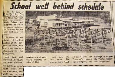
Newspaper - Newspaper Clipping - Digital Image, Diamond Valley News, School well behind schedule, and, Lake forms in school ground, 1970
Two articles on the building of Montmorency High School (Mo8068). "School well behind schedule" (20/01/1970) describes the delay in completing the building and shows temporary classrooms behind the frame of the new building. "Lake forms in school ground" (24/03/1970) shows storm water laying on the ground at the school site.Digital copy of newspaper articlemontmorency secondary college, montmorency high school -
 Tarnagulla History Archive
Photograph of Flour Mill, Tarnagulla, Flour Mill, Tarnagulla, circa 1920
... buildings ...Murray Comrie Collection. Information written by Murray Comrie: A meeting was called at the Golden Age Hotel on 11th June 1868 when it was resolved to build a flour mill. Tenders were called by H.C. Bristol, in the Tarnagulla Courier of January 10, 1874, for the erection of the mill. Building of the Mill commenced in 1874. Pipes were laid to Company's Dam to obtain water for the Mill's boilers. Steam was got up for the first time on 30th March, 1882. A boiler burst about April 29th. Two men (J.H. Smith and W. Hargreaves) died as a result and two others were seriously injured. The mill commenced operations on 13th June 1882 with Mr. W. Fitzgerald as manager. Thomas Comrie was the proprietor and was responsible for the Mill being built. The Mill operated with grinding stones until 1899 when new rollers and a considerable amount of new equipment was installed, including a new, more powerful engine to drive the Mill. In January 1901, 6,000 bags of wheat were received weekly and it was a common sight to see the streets lined with wagons. In 1913, 15,000 bags of wheat were bought at three shillings and four pence per bushell. In January 1914, wheat came in at the rate of 1500 bags a day with 20,000 bags in storage. Thomas Comrie died on 4th August 1910. The Mill was carried on by his executors, then closed for a short period prior to being sold in September 1918 to a Mr. O. Albert of Talbot. Albert operated the Mill for a few years but during the 1920s it was closed down and then pulled down. It was later re-erected at Mildura where it operated for many years. This is a poor copy of an older original. Copy probably made by Murray Comrie in the late 1960s. Monochrome photograph of the Flour Mill in Tarnagulla, around 1920.tarnagulla, commerce, agriculture, food production, mill, milling, horses, transport, buildings, commercial road, main street -
 Tarnagulla History Archive
Photograph of Flour Mill, Tarnagulla, Flour Mill, Tarnagulla, circa 1920 (original image)
... buildings ...Murray Comrie Collection. Information written by Murray Comrie: A meeting was called at the Golden Age Hotel on 11th June 1868 when it was resolved to build a flour mill. Tenders were called by H.C. Bristol, in the Tarnagulla Courier of January 10, 1874, for the erection of the mill. Building of the Mill commenced in 1874. Pipes were laid to Company's Dam to obtain water for the Mill's boilers. Steam was got up for the first time on 30th March, 1882. A boiler burst about April 29th. Two men (J.H. Smith and W. Hargreaves) died as a result and two others were seriously injured. The mill commenced operations on 13th June 1882 with Mr. W. Fitzgerald as manager. Thomas Comrie was the proprietor and was responsible for the Mill being built. The Mill operated with grinding stones until 1899 when new rollers and a considerable amount of new equipment was installed, including a new, more powerful engine to drive the Mill. In January 1901, 6,000 bags of wheat were received weekly and it was a common sight to see the streets lined with wagons. In 1913, 15,000 bags of wheat were bought at three shillings and four pence per bushell. In January 1914, wheat came in at the rate of 1500 bags a day with 20,000 bags in storage. Thomas Comrie died on 4th August 1910. The Mill was carried on by his executors, then closed for a short period prior to being sold in September 1918 to a Mr. O. Albert of Talbot. Albert operated the Mill for a few years but during the 1920s it was closed down and then pulled down. It was later re-erected at Mildura where it operated for many years. This is a poor copy of an older original. Copy probably made by Murray Comrie in the late 1960s. Monochrome photograph of the Flour Mill in Tarnagulla, around 1920. Cropped version of 2019.0047.tarnagulla, commerce, agriculture, food production, mill, milling, horses, transport, buildings, commercial road, main street -
 Eltham District Historical Society Inc
Slide, Old Eltham Bakery and cottage, cnr of York Street and Main Road, Eltham, c.Jul 1974
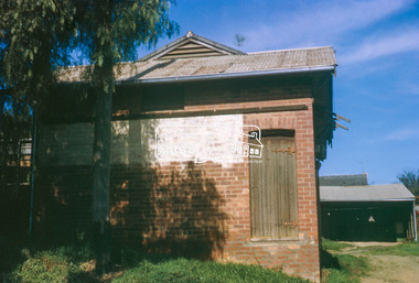
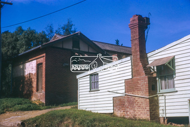
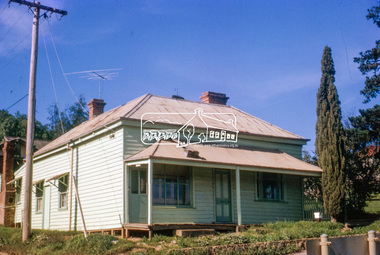
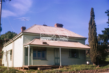
The old weatherboard building, possibly dating from the 1860s, comprised a dwelling with a shop in the front room opening off a timber verandah deck which directly fronted the Main Road footpath. At the rear was a brick building of much later date which was for many years used for the bakery. The buildings were demolished in 1979 for construction of flats.35 mm colour positive transparency (x5) Mount - Kodak Kodachrome CardProcessed Jul 1974bakery, eltham, main road, york street -
 Eltham District Historical Society Inc
Slide, Old Eltham Bakery and cottage, cnr of York Street and Main Road, Eltham, c.Jul 1974
The old weatherboard building, possibly dating from the 1860s, comprised a dwelling with a shop in the front room opening off a timber verandah deck which directly fronted the Main Road footpath. At the rear was a brick building of much later date which was for many years used for the bakery. The buildings were demolished in 1979 for construction of flats.35 mm colour positive transparency Mount - Kodak Kodachrome CardProcessed Jul 1974bakery, eltham, main road, york street -
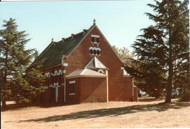 Hume City Civic Collection
Photograph, c 1990s
St. Andrew's Uniting Church, formerly the Presbyterian church includes two different church buildings as well as a new addition built at the rear of the 1904 red brick building. A small weather board structure was used as a church until the Romanesque brick building opened in 1904. The new church extensions were completed on 14 December, 1986.A rear view of St. Andrew's Uniting Church before the extensions were built. The photograph shows the small apse and porch as well as the surrounding conifers which were growing in the church grounds.churches, religion, tompkins, f. b., h. w., goyen, w. rev., st. andrew's uniting church, presbyterian church, george evans collection