Showing 24981 items matching " north"
-
 Melbourne Tram Museum
Document - Form/s, Melbourne & Metropolitan Tramways Board (MMTB), "Transportation of Cars", 1959
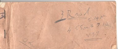
Book of forms titled "Transportation of Cars" printed with brown card covers, stapled on the left hand side, with white, pink and blue copies for providing advice to Preston Workshop of the tramcars being sent to the workshop and the defect to be attended to. Has the tram car number, depot, date, signature etc. Used by North Fitzroy depot, the first to have Z class trams. First use was for Z1. Each form has been handwritten using carbon paper or ink.Has various notes on the front cover about times, etc.trams, tramways, tramcars, z class, north fitzroy depot, maintenance, preston workshops, rolling stock -
 Melbourne Tram Museum
Document - Report, P. J. Pringle for the Tramway Board, "Yoke Frames for Supporting line pulleys in tunnel", 18/10/1916 12:00:00 AM
Report - four foolscap sheets, clipped in top left hand corner titled "Yoke Frames for Supporting line pulleys in tunnel", dated 18/10/1916 by Mr. P. J. Pringle for the Tramway Board. Report on issues with the cable tramway yokes looking at the problems with wear, cracking, dimensions, and depth that the grip could run. Noted differences between the south and north sides of the system. Work done by Mr Blackwell and Mr. Watt. Has two sheets of tables listing the problems.trams, tramways, cable trams, cable grip, cables, maintenance, track repairs -
 Melbourne Tram Museum
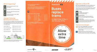
Pamphlet, Public Transport Victoria (PTV), "Bus replace trams - tram route 96", Apr. 2019
Pamphlet - 4 fold DL full colour, titled "Bus replace trams - tram route 96" for the period 10 May to 18 May 2019, to undertake track work and installation of super stops in Nicholson St north of Holden St. Has alternative transport routes and stop changes. Shows the map of work and alternative services. Has the Transport for Victoria, Yarra Trams and PTV logos. Published April 2019. See Reg Item 3630 for other associated documents for this project.trams, tramways, nicholson st, route 96, trackwork, superstops, yarra trams -
 Melbourne Tram Museum
Photograph - Block Mounted Photograph, Surrey Hill Neighbourhood Centre, 1926
Photograph - mounted onto a heavy card, numbered 65-575 in the top right hand corner of Whitehorse Road Balwyn, looking east from near corner of Balwyn Road in 1926. Notes that the image is courtesy of the TMSV. See image i2 for the actual photograph. 4673.1 - loose print of the photograph with the words on the rear: "Melbourne / Whitehorse Road, eastwards at Balwyn Road, Balwyn (Building at left with domed tower is on north west corner). Probably early 1930's.On rear in ink "Copied for Keith Kings, Nov. 2002" and the "Surrey Hill Neighbourhood Centre" stamp.trams, tramways, whitehorse road, balwyn -
 Melbourne Tram Museum
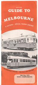
Pamphlet, J B Publications, "Visitors Guide to Melbourne", May. 1974
Pamphlet - 28 pages, centre stapled titled "Visitors Guide to Melbourne", dated 20 May 1974. Has on front cover trams W7 1032 and PCC 1041 with the caption "Melbourne's Trams - the old and the new" Has many advertisements, a small map, places of interest including Sovereign Hill, Leonda, driving in central Melbourne and wearing of seat belts. Has photo looking north along Swanston St - see image 2. Welcome by Minister for Tourism Murray Byrne.trams, tramways, melbourne, visitors, guides, w7 class, 1041, tram 1032, tram 1041 -
 Melbourne Tram Museum
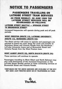
Document - Notice, The Met, "Notice to Passengers travelling on Latrobe Street tram services", Jun. 1989
Notice - A4 sheet - titled "Notice to Passengers travelling on Latrobe Street tram services" - advising that from Monday 26/6/1989, increased frequencies on the shuttle between Spencer St and Brunswick St, alterations to the routes 13, 14 and 93 - West Preston, Latrobe Uni and Bundoora and the Mont Albert route 23 and North Balwyn (route 24) services. Contact details provided and that timetables are available from The Met shop and depots. Two copies held.trams, tramways, the met, latrobe st, la trobe st, route 13, route 14, route 93, route 23, route 24, west preston, latrobe university, bundoora, mont albert, north balwyn -
 Melbourne Tram Museum
Photograph - Set of 3 Colour Print/s, Colin Rough, 27/01/2002 12:00:00 AM
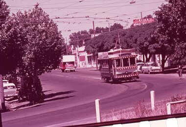
Set of three Colour prints of Brunswick Depot. 27/1/2002 .1 - General view across the yard with Z3 and B class trams (appear to be 2006 and 2098) .2 - View with Z3 129 on the grinder siding and other trams in the background. Has the Depot Allocation Screen showing the location for tram 183. .3 - Looking north along Cameron St, with Z3 183 with the destination Moreland, running in. In the background is the Upfield Railway line. Photos shows the two signals in the street.On rear in ink "Brunswick Depot Melbourne 27/1/02" and (Col's 1st Aussie job) M&MTB 27/1/02"trams, tramways, brunswick depot, z3 class, b class, moreland, cameron st, signals, tram 129, tram 2006, tram 2098, tram 183 -
 Melbourne Tram Museum
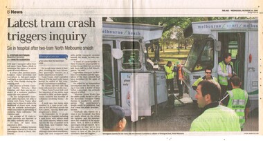
Newspaper, The Age, "Latest tram crash triggers inquiry", 24/10/2007 12:00:00 AM
Newspaper clipping from The Age, 24/10/2007, titled "Latest tram crash triggers inquiry" with sub heading "Six in hospital after two tram North Melbourne smash". Reports on the collision between Z3 134 and B2 2080 in Flemington Road the previous day. Reports on various recent tram accidents. Quotes Dennis Cliche, John Brumby, Terry Mulder and Minister Lynne Kosky. Article by Stephen Moyninan and Grietta Guerrera with photo by Andrew De La Rue.trams, tramways, accidents, flemington road, b class, z3 class, tram 134, tram 2080 -
 Melbourne Tram Museum
Negative, Wal Jack, 15/03/1945 12:00:00 AM
.1 - Black and white negative, by Wal Jack, of scrubber 5 at the Maribyrnong River terminus. The cross over is in front of the tram. In the background is a shop advertising Robur Tea. Also reversing is W5 804 (City via North Melbourne Route 54). Note the tram stop sign by the house and the bus stop sign on the other side of the road, along with "end of section" signs. Photo dated 15-3-1945 in the Wal Jack album along with details of the location and the tramcar.trams, tramways, maribyrnong rd, scrubber tram, work trams, w5 class, tram stops, tram 5, tram 804 -
 Linton and District Historical Society Inc
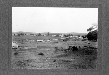
Photograph, Linton Township from Slaughterhouse Hill, circa 1920s, 1920
Slaughterhouse Hill was so named because Bennett's butchers had a slaughterhouse there.A view of Linton taken from Slaughterhouse Hill to the north-east of the town. Numerous buildings are identifiable in the photograph. In the middle foreground are the railway station, platform and station-master's house. The Grenville Standard building is visible in Clyde Street, and the Post Office and Bank of NSW buildings can be seen near the corner of Clyde and Sussex Streets. In the distance (along Sussex Street) the Royal Standard Hotel and the Shire Offices (original building) can be seen. St Paul's Church of England is on the far left of the photograph."Esther Cluff, Linton".linton township, slaughterhouse hill -
 Melbourne Tram Museum
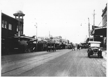
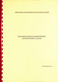
Document - Report, Melbourne & Metropolitan Tramways Board (MMTB), "Trial Installation of Barrier Kerbing, Nicholson Street - Fitzroy", Nov. 197
Report, manila covers, A4 paper, white comb binder, 30 pages, 1 photograph page of Nicholson St, looking north with a Z class tram in the distance, tables of traffic timing, looking at the impact of concrete barrier kerbs laid along the eastern side of Nicholson St Fitzroy between Alexandra Parade and Victoria Parade, 12 month trial. Report dated November 1976. Includes impact on traffic and tram services. 2nd copy added 23/10/2014.Marked number "85" in top right hand corner and stamped on cover and inside cover page "Discarded from PTC Library 22 Oct 1989". 2nd copy ex AETA marked "4E13" in top right hand corner of cover.trams, tramways, mmtb, nicholson st, fitzroy, traffic control -
 Melbourne Tram Museum
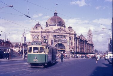
Slide - Set of 2, Warren Doubleday, 9/03/1970 12:00:00 AM
Set of 2 Colour slides- Anscochrome plastic mount taken on 9-3-1970 of the shunting of trams for the Moomba Parade Flinders St with the Flinders St Station in the background. .1 - W5 815 (East Kew, route 40) shunting alongside the Gas and Fuel building. An inspector is standing behind the tram. .2 - SW6 939 (North Balwyn, Route 48), shunting in Flinders St with many people alongside. Has adverts for Astoria Rental cars and Houghtons blinds.Has slide number written on itemtrams, tramways, w5 class, route 40, east kew, flinders st, moomba, parades, flinders st station, route 48, north balwyn, tram 815, tram 939 -
 Bendigo Historical Society Inc.
Document - NORTH DEBORAH GOLD MINING CO N. L. - NORTH DEBORAH MISCELLANEOUS REPAIR COSTS
Three small, blue handwritten pages of costs of repairs, with typed copies of same, listing some stores and cost of cartage by W. McCulloch & Co. Dates 1940 - 41. Most of the repairs/installation are electrical, including installation of extra lights, installing wiring for 2.1 H P motor and alteration to main switchboard. Stores include globes, lamps and a hydraulic jack. Note at the bottom: All information from papers found on floor of North Deborah Managers Office. Albert Richardson Collection. document, gold, north deborah gold mining co n. l., north deborah gold mining co n. l., north deborah miscellaneous repair costs, w mcculloch & co, ludowice bell -
 Bendigo Historical Society Inc.
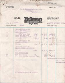
Document - NORTH DEBORAH G. M. CO. N. L. -HOLMAN BROS INVOICES TO NORTH DEBORAH G. M. CO. N. L
Four invoices from Holman Bros. (Australia) Pty. Ltd. Collins House, 360 Collins Street, Melbourne, C. 1 to North Deborah G. M. Co. N. L.. Invoices are numbered:- 12360, 12363, 11442 and 11462. Invoices are mostly for hose fittings, also some bushings and pistons. Three lots of goods were sent by passenger train and the fourth by post. Dates are26th and 28th February 1951 and 20th February and 24th February 1950. Albert Richardson Collection. document, gold, north deborah g. m. co. n. l., north deborah g. m. co. n. l., holman bros. (australia) pty ltd, invoices to north deborah g. m. co. n. l. -
 Kew Historical Society Inc
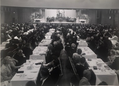
Photograph, Centenary Dinner Dance, Kew Civic Hall, 1960
Original photograph of the Kew Centenary Ball in the new Kew Civic Hall in 1960. The photograph formed part of the collection of WHS Dickinson and was presented to the Kew Historical Society by his daughter in 2018. Original black and white photograph of the seated invited guests at the dinner celebrating the 100th anniversary of the declaration of Kew as an independent municipality. The point of view is from the south end of the building, looking towards the stage at the north end of the main hall. [Originally both halls could be separated or joined by concertina doors.] On the stage, centre, is from left Mr. W. Birrell [Town Clerk], Cr WHS Dickinson [the Mayor], and The Rt Hon Robert Menzies, MP for Kew and Prime Minister of Australia.cr whs dickinson - mayor of kew 1946-1947, civic events - kew (vic), centenary of kew (vic) - 1860-1960 -
 Lakes Entrance Historical Society
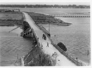
Postcard - North Arm bridge Lakes Entrance Victoria, 1917c
Also sepia toned photographic print 10cmx15cm, good condition old cat No 310 or 318? (Club Hotel and Hummocks area cropped from top) also Black and white photographic print 12.5cmx18cm, good condition- 2 copies 'Original T-Beam bridge opened Sept 1917 on reverse P01151-3.Black and white photographic miniature postcard showing the concrete bridge over the North Arm, showing the extended abutments, and shortened bridge length compared to previous bridge, causing restriction of waterway. Two walkers and horse drawn vehicle, buggy, on bridge. Remaining piles of wooden bridge upstream of bridge, telegraph poles upstream of bridge and across mudflats. Bridge to Bullock Island from mudflat, Club Hotel, Cunninghame Arm, and sand hummocks in distance. Lakes Entrance Victoriabridges, waterways, coast, transport, hotels -
 Ringwood and District Historical Society
Document, Lease of land in Ringwood by Mr R A Mason of Maroondah Garden Supplies - Circa 1960s
Correspondence between Mr R A Mason and City of Ringwood regarding lease of Council land North side of Maroondah Highway adjacent to the E.S.& A Bank West End Branch premises.Land situated at 91 Maroondah Highway Ringwood. Also correspondence between Mr Mason and the E.S.& A Bank re leasing of land from the Bank. Related documents to setting up Maroondah Garden Supplies business by Mr Mason on leased land. Permits and Leasing Agreements and other miscellaneous documents. -
 Bendigo Historical Society Inc.
Document - ALBERT RICHARDSON COLLECTION: UNITED HUSTLERS AND REDAN MINE
Four-page typed document plus location map. The United Hustlers and Redan mine was located in the North Bendigo, Long Gully area on the Hustlers line of reef. The lease was 153 acres and included Holdsworth, Holmes, Havilah Roads and Wood Street. The Redan shaft was 1,830ft and the South or K.K. Shaft was 1,960 ft. Poppet legs steel 71 ft high. Features of the plant are described including the engine house, winding engine, air compressor, boilers, fuel, winding ropes.bendigo, mining, united hustlers and redan mine -
 Bendigo Historical Society Inc.
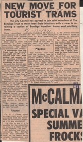
Newspaper - BENDIGO ADVERTISER DECEMBER 20, 1971 NEWSPAPER ARTICLE ''NEW MOVE FOR TOURIST TRAMS'', 20/12/1971
BENDIGO ADVERTISER DECEMBER 20, 1971, NEWSPAPER ARTICLE ''NEW MOVE FOR TOURIST TRAMS''. (Local Ministers:) Minister of Fuel and Power Mr. Balfour, Local Government Minister Mr. Hunt, Minister for Tourism Mr. Dickie. Councilors T.R. Flood, J.C.M. Jeffrey, N.J. Oliver, J.P. Pearce, Mr. V.L. Smythe. Proposal of the time run tourist trams from Central Deborah Mine through to Emu Point in North Bendigo taking in Pall Mall and McCrae Streets.bendigo, newspapers, bendigo advertiser tourist trams -
 Bendigo Historical Society Inc.
Document - NEW CHUM & VICTORIA LINES OF REEF - PRODUCTION OF GOLD (OUNCES)
Handwritten notes with production of gold from some of the mines. Some have the number of ounces per ton and the average per ton of ore. Mines mentioned are Lazarus, Old Chum 7 Early Grou?, New Chum & Victoria, North Old Chum, Lansell's 180, Victoria Quartz, Gt Central Victoria, Victoria Colsols, South Adventure Group, Adventure, Advance, Try - Me - Well, Prince Alfred, Alfred Co, Ironbark Co, Herc & Energetic.document, gold, new chum & victoria lines of reef, production of gold (ounces), lazarus, new chum & victoria, north old chum, lansell's 180, victoria quartz, gt central victoria, victoria consols, sou;th adventure group, adventure, advance, try - me - well, prince alfred, j r evans, ironbark co, herc & energetic -
 Bendigo Historical Society Inc.
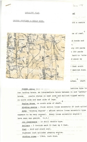
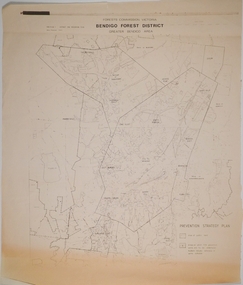
Map - CAMPBELL COLLECTION: BENDIGO AND DISTRICT MAPS, 1982
Map. Forest Commission Victoria, Bendigo Forest District, Greater Bendigo Area. Shire of Marong, Sailors Gully, Epsom, Borough of Eaglehawk, Jackass Flat, White Hills, California Gully, Shire of Huntly, Maiden Gully, Long Gully, North Bendigo, Bendigo East, City of Bendigo, West Bendigo, Kennington, Shire of Strathfieldsaye, Flora Hill, Quarry Hill, Golden Square, Kangaroo Flat, Spring Gully. Prevention Strategy Plan. Base prepared 1982.map, bendigo, forest district -
 Eltham District Historical Society Inc
Slide, Maroondah Aqueduct, Research, Victoria, 22 Mar. 1981
An inspection tour of the Maroondah Aqueduct was undertaken by the Shire of Eltham Historical Society on Sunday, March 22nd, 1981, commening where the aqueduct crosses Main Rd., Research, just below Eltham College. The Maroondah Aqueduct was part of Melbourne’s water supply system. It carried water over the 66 km from the Maroondah Reservoir on the Watts River at Healesville to the Preston Reservoir. Of this length, 41 km were open channel, 10 km, tunnel through hills and 15 km in 14 inverted siphons across stream valleys. The route of the aqueduct is north of Tarrawarra and Yarra Glen, along the Yarra escarpment south of Christmas Hills and crossing Watsons Creek into the present Shire of Eltham near Henley Rd. The eastern part of the route lies entirely within the former boundaries of the shire. The aqueduct passes south of Kangaroo Ground to Research and crosses the Diamond Creek by siphon at Allendale Rd., Eltham North. It then extends to Reservoir via St. Helena, Greensborough North and Bundoora. Water first flowed through the aqueduct in February 1891 when it was fed by a diversion weir on the Watts River. Records of the building of the aqueduct indicate that it was a significant construction achievement. The present Maroondah Reservoir was completed in 1927 and the aqueduct was enlarged at that time to take increased flows. About 1971 the section of the aqueduct through and north of Research was replaced by a large pipe and that section of the channel is now unused. The channel has remained largely intact (unlike sections at Greensborough and Bundoora where long lengths of the disused aqueduct have been demolished or filled in). The M.M.B.W. relinquished control of the disused aqueduct reserve which is crown land and the Shire of Eltham took control of this section of the reserve as a linear park. The Maroondah Aqueduct is considered to be an important historic structure, not just to the local area but to the metropolitan area generally. It is considered important to preserve substantially intact long lengths of the disused aqueduct, together with its bridges and other associated structures. 35 mm colour positive transparency (1 of 5) Mount - Agfachrome Agfa CS System black 8 dotsactivities, heritage excursion, maroondah aqueduct, research (vic.), shire of eltham historical society -
 Ballarat Tramway Museum
Slide - 35mm slide/s - set of 4, Noel Simons, Apr. 1967
Set of 2 slides made from the Association of Railway Enthusiast Provincial Tramways film strip, possibly during April 1967. 1192.1 and 1192.3 mounted in Kodak Ready Mounts. The others in plain white mounts. Slides dated Dec. 1968. 1192.1 - No. 21 out bound to Golden Square in High St., between Wattle and Vine Streets. Photo taken after tram has passed photographer. Has a sign for "Reid's Furnituorium" in the background. 1192.2 - Bendigo No. 28 dressed up as Myers Christmas tram, passing the Post Office and Courts in Pall Mall. 1192.3 - Bendigo No. 23 at Needle Loop en route to Eaglehawk. Tram has two SEC roof ads, one "Electric Cooking" and the other "Everything fine in my all electric kitchen". 1192.4 - Bendigo scrubber parked at the end of the main depot lead, alongside the depot office buildings.Details in blue ink, date hand stamped in purple ink. 1192.1 - "No. 21 heads along High St for Golden Square between Wattle and Vine Streets." 1192.2 - "Birney No. 28 in Christmas Garb, traverses Pall Mall en route to North Bendigo". 1192.3 - "No. 23 at Needle Loop on its run to Eaglehawk". 1192.4 - "Scrubber car at Bendigo Depot".tramways, trams, north bendigo, bendigo, bridge st loop, depot, tram 21, tram 23, tram 28, tram scrubber -
 National Communication Museum
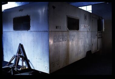
Vehicle - Mobile Telephone Exchange, c. 1965
Manufactured in the 1960s, this mobile emergency telephone exchange was fitted into a caravan. Part of the Shepparton Division State Disaster Plan, the caravan could be towed to areas affected by disasters to enable communications to recommence. The caravan remained in service until approximately 1974.Mobile infrastructure plays an important role in Australian communications, owing to the often remote and hostile environments in which Australians live and work. Exchanges such as this facilitated phone calls in the aftermath of an emergency, particularly for hospitals, police and other emergency services. Today, Mobile Exchange on Wheels (MEOWs), Cell on Wheels (CoW) and Satellite Cell on Wheels (SatCOW) - which provide temporary landline and broadband services, mobile phone coverage and service in areas without communications infrastructure respectively - are a critical part of emergency response procedures for natural disasters such as fire and flood. Though technology has progressed, the need for rapid service in remote areas remains a present concern of the communications service providers in Australia. This mobile service infrastructure is historically significant as an early example of a service which has evolved over decades, yet is still needed today. The exchange, as a representative example of a vehicle which would provide early-response in a disaster, is socially significant as a facilitator of critical communications needs in devastated communities: access to emergency services and contact with family and friends. The exchange itself, intact from its period of use, provides an insight into technology of the 1970s.Mobile emergency exchange housed in a caravan trailer on 2 wheel base, duralin body, steel tow bar, Caravan divided into 3 sections; the exchange room; the relay room and the main frame room. The exchange room contains 3 switchboards, a folding table, cupboards, benches and switch rack (.1). table (.2), steel bar for attaching the table (.3), back boards of switchboards (.4-.6), switches (.7-.16), box of switches (.17). There is a wall phone magneto, 300 type handset on wall and 2 skylights with wire screens. .11? hat pegs and shelf; there are 2 fluorescent tubes for lighting, all in exchange section. The floor is covered with 2 tone grey tiles and there are wire mesh on outside of windows and a geometric curtain inside behind switch rack. There is a flywire screen door as well as exterior door. The relay room has a sectioned door so half can open at a time. Room contains a cupboard with folding bench top beneath a curtained window. The opposite wall has a bank of batteries and transmission condensers; there is a shelf above window, one fluorescent tube and fuse boxes. Tiles on floor also. The main frame room contains many metres of coiled black covered cable, a black covered magneto wall telephone with 300 type handset; grey plastic jumper cords, a rack of termination points and wire with wasp nests attached. There is a small iron step under door, a fluorescent tube on wall and 3 hat hooks. Roll of Paper Handtowels (.18), cord and handle (.19), red exchange cords and plugs (.20-.22), plastic aluminium runners (.23,.24), headset (.25,.26), logbook (.27), battery readings (.28), box containing papers circuit drawings etc (.29-.93), paper lists off wall (.94,.95). Books, record books etc (.96-.103). Manila folder (.104) containing circuit drawings (105-.124). Wooden drawer (.125), metal drawer containing subscribers master cards, record of faults cards, particular switchboards connected, Junction line cards (.126). Box of valves (.127), box of clamps (.128). Box of 2000 type rack fuses, red 1 1/2 AMPS, black 3 AMP, blue 1/2 AMP (.129). Box of sleeves for covering wire joints (.130), plastic beakers (.131,.132), soap (.133), box of white plastic squares (.134), time switch "Venner BF/43 time switch" Made in England (.135), box of bolts, knobs etc (.136), box of switchboard number indicators (.137), fuse (.138), fuse wire (.139), football card (.140). Box of cartridge fuse 6 AMP (.141). Envelope of drawing pins, rubber bands (.142), black plastic, paper tape centres (.143-.152), metal plug (.153), 2 signs "Beware of vehicles" (.154-.155). Paper listing Naringal East automatic conversion (.156). Green Commonwealth of Australia note pad (.157). Wiring plug for tail lights (.158). Black fuse plugs (.159,.160). Box of bolts (.161). 2 sections of blue plastic coated wires (.162,.163). Gloves used for working on batteries (.164-.167). Wasp nests (.168,.169). White fuse (.170). Photographs of van in use (.171,.172)..1 on front: "ANOTHER / MOBILETRAIL / PRODUCT" "MAX SPEED / 25MPH" "TRAILER BRAKES / --- / " On sides: "EMERGENCY TELEPHONE EXCHANGE" "NO 1" "PMG" "TCQ / GROSS 250 / TARE 182 / LOAD 162" "6" "COUNTRY BRANCH / NORTH REGION / [SHEPPARTON DIVISION]" "LAW'S SIGNS" "Telecom Australia" On back: "DANGER / LONG LOAD" "MQA 3787" .133: "FIR OIL" "AUSTRALIA"mobile telephone exchanges, mobile telecommunications trailers, trailers, transport, natural disaster, black saturday, bushfires, floods, emergency communications -
 Ringwood and District Historical Society
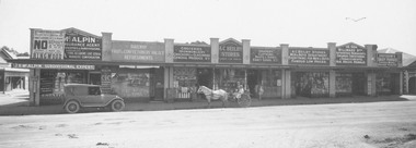
Photograph, Maroondah Highway Central, Ringwood. Beilby Stores, 1924. (See also MHC0115)
Black and white photograph. Typed below photograph: "1924 Whitehorse Road shops. Entrance to Ringwood Hall on left. Post Office on right.". Image shows shops on north side of road including Beilby Stores and McAlpin's estate agency. Motor vehicle and horse and cart out front of shops. Sign on McAlpin's store advertising Ringwood Heights Estate to be sold 1st March, 1924. -
 Ringwood and District Historical Society
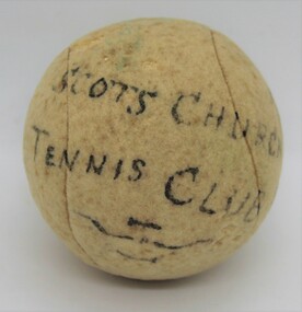
Memorabilia, Letter from Robin Randall with original tennis ball from opening of Scots Church Tennis Club Ringwood - 1929
Tennis ball with typed letter outlining the occasion of Scots Church Tennis Club opening in Ringwood in 1929 and background history of Hamlton family in South Warrandyte.Tennis ball inscription - Scots Church Tennis Club opened by Miss A. Russell, 28-9-1929. The accompanying letter mentions Miss Russell was Secretary of Ringwood Presbyterian Church Ladies Guild around that time, and that Trevor Hamilton took on the post of Head Teacher at South Warrandyte State School in 1925, and later taught at Ringwood and Ringwood North State Schools. -
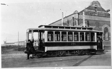 Melbourne Tram Museum
Negative - U206 outside Essendon Depot, Wal Jack collection, 1925
Photograph of U206 in Mount Alexander Road, with the NMETL brick powerhouse behind. The driver is hopping off the tram (to attend points) while the conductor is on the rear platform. Note the drop bars rather than folding gates as on other cars. The Cooling tower is not in the photo, indicating it has been demolished. The Power Station was demolished in 1925 (check). In the background is the St Georges Anglican church which was built during 1925. Sun angle - possibly winter.Yields information about Essendon depot and tram U 206, 1925.Black and White Copy Negative Photograph and print with details on the rear.In ink on the rear "MMTB U class 206 ex North Melbourne Electric Tramways (Essendon), outside depot in Mt Alexander Road, Ascot Vale, called Essendon, 1925. The brick building was pulled down a few years ago for a modern layout. See April Tram Tracks." Has both the Ken Magor stamp and Wal Jack stamp with "T70" written in.trams, tramways, u class, mount alexander road, essendon depot, nmetl, tram 206, mmtb