Showing 24117 items matching " ocean"
-
 Lakes Entrance Historical Society
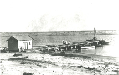
Photograph - Snowy River.Marlo Victoria, 1910 c
Black and white photograph showing four small boats at jetty near mouth of Snowy River. Shed at left crane at end of jetty. Three ladies walking on jetty and people in front of shed and three people sitting in shade of shed at left. Trolly on rails on jetty, sand dunes across river and ocean beyond dunes Marlo Victoriarivers, boats and boating, jetties -
 Mission to Seafarers Victoria
Letter - Correspondence, 23.10.45
Letter from Allan Quinn to his mother which depicts his journey from Adelaide to San Francisco.This letter is of historical, social and interpretive significance as it provides information about the life of a seaman during the mid 20th century. Two page, double sided letter (0307.A1-A2) written on blank paper with blue ink and envelope (0307.B)Top right corner of letter: "M.I Goonawarra San Francisco/ U.S.A 25.10.45" Envelope: "Mrs S Quinn/San Lorenzo/63 Ocean beach/Manly NSW Australia" There is one postage stamp in the top right hand corner and three ink stamps.allan quinn, mission to seafarers, 1945, letter adelaide, san francisco -
Mission to Seafarers Victoria
Letter - Correspondence, 20/5/46
Letter written from Allan Quinn to his mother in 1946 depicting his time sailing across Europe.These letters are of historical, social and interpretive significance as they provide information about the life of a seaman during the mid 20th century. Two page, double sided letter (0326.A1-A2) written in blue ink. Dated 20/05/46 while at sea and envelope (0326.B)Envelope: "Mrs S Quinn/San Lorenzo/63 Ocean Beach/Manly N.S.W/Australia" There are 5 postage stamps running along the right hand side, as well as two ink stamps. Letter: Sky Mail symbol on top left hand cornerallan quinn, mission to seafarers, 1946, europe -
 Ballarat Heritage Services
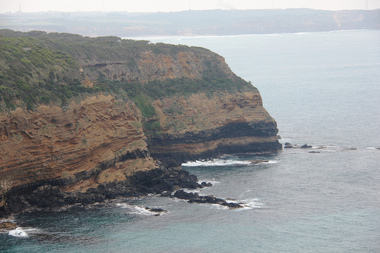
Digital photograph, Lisa Gervasoni, Portland, c2015
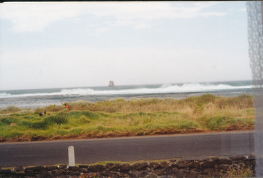
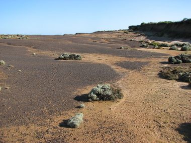
cape bridgewater, geology, ocean, coastal, landscape, seascape -
 Ballarat Heritage Services
Digital photograph, Lisa Gervasoni, Cape Bridgewater, c2015
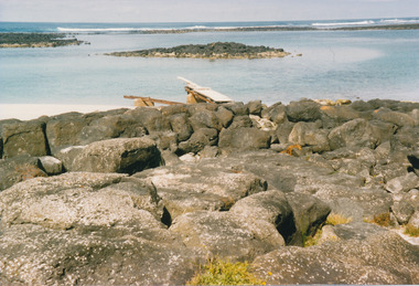
cape bridgewater, geology, ocean, coastal, landscape, seascape -
 Ballarat Heritage Services
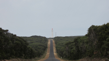
Digital photograph, Lisa Gervasoni, Cape Bridgewater, c2015
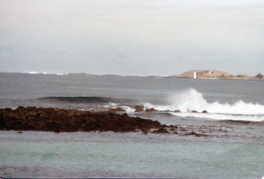
Colour photograph of the road to the Cape Bridgewater lighthouse. cape bridgewater, geology, ocean, coastal, landscape, lighthouse -
 Port Fairy Historical Society Museum and Archives
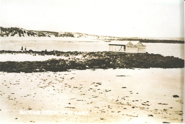
Photograph, Bathing Beach Port Fairy
Photograph of v shaped stone reef with bathing boxes perched on topBathing Beach Port Fairybathing box, south beach, ocean, sea, rock, reef -
 Port Fairy Historical Society Museum and Archives
Photograph
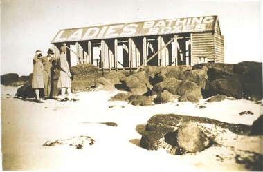
Ladies bathing boxesPhotograph Ladies bathing boxes on stone reef with two women and a man standing in frontbathing boxes, ladies, beach, south, ocean, sea -
 Port Fairy Historical Society Museum and Archives
Photograph
The Crags - west of Port Fairy 1977Photographcrags, west, port fairy, the craigs, ocean, sea -
 Port Fairy Historical Society Museum and Archives
Photograph
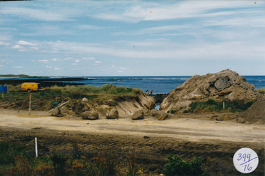
South Beach DevelopmentColoured photograph of Drain being dug for South Beach Estatesouth beach, development, drain, sea, ocean, reef -
 Port Fairy Historical Society Museum and Archives
Photograph
South Beach Development south beach, development, road making, street, ocean, sea -
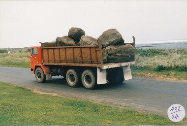 Port Fairy Historical Society Museum and Archives
Photograph
South Beach Development Coloured photograph of Large tip truck with load of bluestone sea in background407/24 (since removed) south beach, development, truck, bluestone, ocean, sea -
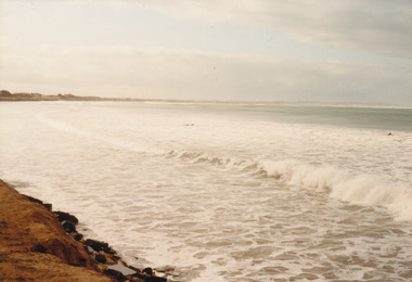 Port Fairy Historical Society Museum and Archives
Photograph
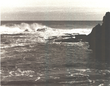
East Beach looking Northeast beach, sea, rough, ocean, dune, tide -
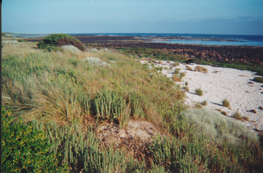 Port Fairy Historical Society Museum and Archives
Photograph
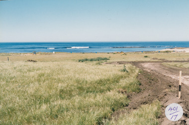
South Beach 2000south beach, 2000, rocks, ocean, sea, dune -
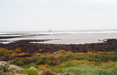 Port Fairy Historical Society Museum and Archives
Photograph
South Beach tall shipsouth beach, ship, sea, ocean, reef, rocks -
 Port Fairy Historical Society Museum and Archives
Photograph
South Beach tall shipsouth beach, ship, sea, ocean, rocks, bluestone -
 Port Fairy Historical Society Museum and Archives
Photograph
South beach diving boardsouth beach, diving, board, sea, reef, ocean -
 Port Fairy Historical Society Museum and Archives
Photograph - Digital copy
Lex Goldie standing on the diving board at the South beachlex goldie, diving, board, south beach, ocean, sea -
 Port Fairy Historical Society Museum and Archives
Photograph
East beach from reefplus photographic copyeast beach, sea, ocean, reef, sand, waves -
 Warrnambool and District Historical Society Inc.
Booklet - Booklet Collection: City of Warrnambool Tourist Guides, Collett, Bain and Gaspar, Warrnambool
This is a collection of sixteen tourist guides dating from the mid 1970's to 2013. These contain listings of businesses, accommodation, eateries and events in Warrnambool and district. They also include maps of Warrnambool and surrounds, advertising and photographs of various attractions. While mainly covering Warrnambool a small number of the guides cover the South West Region. These directories have mainly been published by the Warrnambool City Council and are a selection of the types of information provided to visitors at the Tourist information centre during this time period.These tourist guides give snapshots of the City of Warrnambool for the years covered and will be useful for research.[.1] An 8 page paper booklet with black printing and a black & white photo of the pond at the Botanical Gardens on the front cover. [.2] two photocopied A4 black and white pages from the book "On the Trail" K Winser 1956 (Main Roads of Australia) [.3] A trifold colour brochure with a stylised map of the coast on the yellow and blue front cover. The inside has stylised colour drawings on Warrnambool attractions. The rear cover has coloured photographs of bush, Liebig Street and Fletcher Jones gardens [.4] A trifold black and white brochure with a black line drawing of a whale on the front cover. [.5] A trifold white card with mauve printing. The front cover has a line drawing of the former Timor Street post office and a map of businesses and landmarks in Timor Street. The reverse side contains a brief history of Warrnambool. [.6] A 98 page stapled booklet with a foreword by Vanda Savill. There are 4 pages of coloured photographs. The remainder are black and white photographs. The front cover is purple with white writing in the lower third. There is an outline of the coast and five colour photographs of district attractions. The inside middle page has a map of the Western wonderland region. The content covers towns in this area. Content relating to Warrnambool is in the last six pages. [.7] Twelve loose photocopied black and white pages. The front cover has the Warrnambool Premier Town 1988-1991 logo and a photo of a Southern Right Whale and calf. The bottom right hand corner has a Standard Warrnambool logo. [.8] 44 page booklet printed with blue ink. The staples have been removed. The glossy front cover has blue printing with a coloured photo of Flagstaff Hill Maritime Village pond. The centre pages has a fold out map of the City of Warrnambool. The rear cover has photos of The Twelve Apostles and Hopkins Falls. [.9] 4 loose photocopied pages with Warrnambool Library and Corangamite Regional Library Service Warrnambool City Library black ink stamps. The front page line drawing illustrations of Warrnambool attractions [.10] A single sheet of glossy white paper folded in half to make four pages. The front page has a Warrnambool premier town logo 1979-1982 and blue printing and a visitor survey. [.11] A conference pack of light card folded to make a pocket containing three brochures, a shipwreck coast tourist directory and a Australian Heritage Parks Association conference program dated 24 to 27 May 1992. The front cover of the pack has green writing over a stylised upward arrow. There is a City of Warrnambool logo in the top right hand corner and two film strips diagonally across the cover containing photographs of Warrnambool. The rear cover has a coloured Warrnambool Premier Town logo. [.12] A 63 page stapled booklet with coloured photographs of Warrnambool. The front cover has black writing on white background. There is a coloured photograph of Flagstaff Hill in the middle of the cover and a Warrnambool City and Visit Victoria logos on the lower edge. The middle pages has a coloured of the city of Warrnambool with an inset map of Allansford. [.13] A single large sheet of white paper folded in ten to make a brochure. The front cover has black printing. The rear cover has a purple ink stamp for the City of Warrnambool Tourist Information Centre. When folded out the reverse side has a green, grey and white map of the South West Region of Victoria. [.14] A 48 page colour booklet on glossy paper. The front cover has white writing on a blue background and includes photographs of the Twelve Apostles, the Promenade walk, Flagstaff Hill and a southern right whale's tail. The rear cover has photographs of The Twelve apostles, a passenger train from Melbourne passing the Lake Pertobe playground, and a rural scene. There is white writing and a white Warrnambool City logo on a blue background. The centre pages have a stylised green and blue map of the city of Warrnambool. [.15] A 48 page colour booklet on glossy paper. The front cover has white writing over colour photographs of two people at a lookout, Flagstaff Hill, three southern right whales and a child at the Lake Pertobe playground. The lower edge has blue upper case writing on a white background. The rear cover has a colour photograph of the Twelve Apostles. The lower white border on the rear covers has a a blue and green City of Warrnambool logo and blue writing. The centre pages have a stylised green and blue map of the city of Warrnambool. [.16] A 64 page colour booklet on glossy paper. The front cover has black writing on a black background and there is a photograph of a southern right whale's tail. The lower edge has the Warrnambool City and Visit Victoria Logos. The centre pages have maps of Warrnambool and surrounds. [.1] This week in Warrnambool Vol 2 No. 5 Thurs 1st Feb. For the time of your life [.2] Warrnambool Way [.3] Warrnambool The Holiday Host on the South West Coast with compliments City of Warrnambool and Warrnambool Chamber of Commerce [.4] MMI Insurance presents Whales Giants of the Deep Whale Watcher's Logbook Warrnambool [.5] Warrnambool History began in Timor Street [.6] Western Wonderland Tourist Association [.7] A Premier Arrow Tour of Warrnambool Victoria's Premier Town Australia's Southern Right Whale Nursery [.8] Warrnambool The Heart of Victoria's Great Southwest Visitor's Handbook [.9] What to see in Warrnambool Victoria's Premier City 1979-1982 [.10] Win a Free Holiday & $200 Cash in Victoria's Premier Town [.11] Advancing Warrnambool together! [.12] Great Ocean Road Warrnambool Official Visitor Guide [.13] Tourist guide to the South West Region Victoria All it needs is you [.14] Warrnambool visitor guide 2005 the great ocean road experience attractions accommodation entertainment dining [.15] Warrnambool Visitor Guide 2006 the great ocean road experience Attractions Accommodation Entertainment Dining [.16] Official Visitors' Guide Warrnambool Victoria Australia Discover the Great Ocean Road warrnambool, warrnambool tourist guides -
 Federation University Historical Collection
Document, Ken Clements, Peterborough Puzzles, 2009, 2009
Massacre Bay is located on Victoria's Great Ocean Road, and is in the centre of the Bay of Martyrs. The bay consists of 20 m high, red limestone bluffs. This paper by Ken Clements considers the origin of the term martyr in connection to this location, and where the Aboriginal massacre may have taken place. Thirteen page document by Ken Clements relating to Peterborough, Victoria. Contents include coastal features, local Aborigines, Bay of Martyrs, Massacre Bay, Massacre Hill, Buckley Creek Run, Pioneer Pastoralists, British Traversers, settlers, Peterborough, Maps, tourism, history method. Photographs by Laurie Moore.aborigines, bay of martyrs, massacre bay, massacre hill, buckley creek run, pioneer pastoralists, british traversers, settlers, peterborough, maps, tourism, history method, childers cove, barque children, murnane bay, sandy bay, dog trap bay, buckley creek, viviennes lookeout, stanhope bay, buttres bay, burnies beach, armstrong creek, flaxman hill, antares rock, lovers nook, crofts bay, clements, worm bay, halladale point, the well, wold dog cove, james irvine monument, curdies inlet, squirrel creek, wallaby creek, boggy creek, whiskey creek, pioneer beach, schomberg rock, young australia, spit, crown of thorns, newfield bay, the grotto, london bridge, point hesse, high cliffs, the arch, cape martyr, little massacre bay, aboriginal massacre, ken clements -
 Bendigo Military Museum
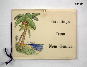
Card - CARD, CHRISTMAS, c1939-1941
Refer to Cat 5109PThis is a folded cardboard card. Inside is a black & white photo of a volcano. Printed on the inside page within the card are the words; " With all good wishes for Christmas and the New Year". On the front cover is a drawing of palm trees, ocean and a ship with the words "Greetings from New Guinea" is printed in black ink. The card has a small piece of purple wool acting has a decorative binder.Written in ink, on the inside page is - "From E H Hildebrandt VX25591 10-12-41" ww2, rabaul, new guinea, christmas card, souvenir -
 Glenelg Shire Council Cultural Collection
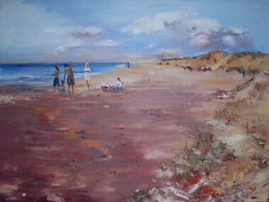
Painting, Julie Kent, Beach Scene, n.d
Hung in CEO's Office 5/9/2003Scene depicting a beach. On the right are sand dunes with grass covering them. On the left is the ocean. The beach runs from foreground left to the upper centre of image, diminishing in size. In centre left of image three standing adult figures and one child stand to the left of a seated figure wearing a red hat. A fishing pole is braced in the sand beside the figure's chair.Front: J Kent (blue paint, lower right) Back: (unknown) -
Glenelg Shire Council Cultural Collection
Postcard - Postcard - Mac's Hotel, Portland, Jan-10
Black and white photo / postcard, fancy border. View from Mac's Hotel - railway cutting in foreground, Henty Beach, band rotunda centre, Railway Pier and Ocean Pier in background, numerous people on lawns above sand. Postmarked Portland, 8.45 am, 31-1-10, on reverse, red 1d stamp (upside down) hand written messageFront: 'View from Mac's Hotel, PORTLAND' - white print, bottom right hand corner 'Vanda' Photo, white print, bottom left hand corner Back: Handwritten message, dated 31/1/10, black inkpostcard, macs hotel, portland -
Glenelg Shire Council Cultural Collection
Booklet, 'Portland Victoria's oldest European settlement is now .... Australia's newest cruise destination, 2011
12 Page promotional booklet to attract cruise ships to Portland. Includes information on attractions in and around Portland, history, Great Ocean Road and specifications of S.L. Patterson Berth where potential cruise ships would berth. Booklet made from light card; full colour; front has image of cruise ship superimposed on old view of Portland Harbour. -
Glenelg Shire Council Cultural Collection
Souvenir - Matchbox Cover, n.d
Identification numbers 6677a, b Two matchbox covers, metal with different views of the harbour, (a) cream background, ocean pier and baths one side, Nuns beach the other, on spine "SOUVENIR OF PORTLAND (VIC)' (b) Green background, harbour including baths, one side 'HISTORICAL PORTLAND THE CRADLE OF VICTORIA', on the other spine 'PORTLAND FOUNDED NOVEMBER 19th, 1834'. -
 National Vietnam Veterans Museum (NVVM)
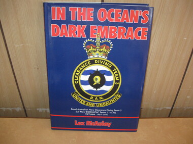
Book, In The Ocean's Dark Embrace, 1997
A book with a blue dust jacket with red writing saying In The Ocean's Dark Embrace at the top. The Clearance Diving Team's insignia is in the middle. In red writing at the bottom of the cover is the auther's name Lex McAulay. Writtend under the insignia in white text is Royal Australian Navy Clearance Diving Team 3 (US Navy EODMUPAC Teams 21 & 35) Vietnam 1967-1971book, ran, cerberus collection -
 Glenelg Shire Council Cultural Collection
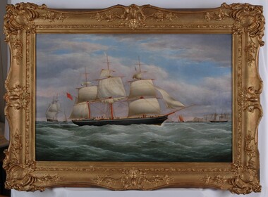
Painting, C Dell, The Francis Henty Homeward Bound, 1856
Art Collection Previously located in History HouseThe painting depicts a large sailing ship with orange masts and is almost in full sail. To the left of the ship are two other sailing ships. To the right are several sailing ships and white cliffs with a port. In the foreground is a rough green ocean with several seagulls in midflight. The background is a blue sky with numerous dark clouds. The work has a heavy gilded ornate frame and exposed canvas.Front: C DELL 1856 Back: Sticker of the Conservation Centre -
 Queenscliffe Maritime Museum
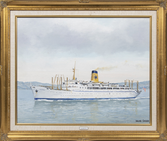
Painting - Mariposa, Dacre Smyth, SS Mariposa
SS Mariposa was a luxury ocean liner launched in 1931, one of four ships in the Matson Lines "White Fleet", which included SS Monterey, SS Malolo, and SS Lurline. She was later renamed SS Homeric. Mariposa was designed for service in the Pacific Ocean, including regular stops in ports along the West Coast of the United States, Hawaii, Samoa, Fiji, New Zealand, and Australia. On the 12th January 1942 the Mariposa left San Francisco in the "Australian — Suva" convoy escorted by two destroyers and the light cruiser and with two other troopships (destined for Suva). This was the first large convoy to Australia after Pearl Harbor with Mariposa transporting Army personnel, ammunition and fifty P-40 fighters intended for the Philippines and Java.Mrs B SmythAn oil painting of the SS Mariposa in an ornate gold frame. Mariposamigrant ships, ss mariposa, wwii -
 Melton City Libraries
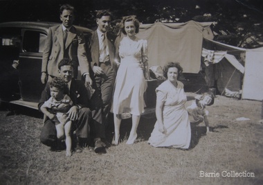
Photograph, Edna and Bon's family camp trip at Apollo Bay, 1948
Wendy Barrie's memories of Apollo Bay The camping trips were a yearly event after the harvest had finished. The trip down to the beach was a much-anticipated event heading out through Parwan and to Geelong leaving behind the hot and dusty plains and our parents relieved to have the hard work of harvesting left behind. The Otways in the distance were reached with great anticipation, Mum in the car and Dad in the Truck ahead of us anxiously winding through the narrow roads and negotiating the hairpin bends and breathing in the cool fresh air of the forest, and keeping an eye out of the log trucks that might come sweeping the corner. The tree ferns with their dripping moisture and the giant trees and the unmistakeable small of the eucalypts. Great excitement was when we caught our first view of the sea from the highest point of the road and then is was the cautious drive the sea level to the sight of the blue ocean with the white of the waves crashing on the rocks and the pristine sand. The water from the Wild Dog and Skenes creek trickling onto the ocean. The tree ferns with their dripping moisture and the giant trees and the unmistakeable smell of the eucalypts. The return journey was usually taken on the Great Ocean Road, it was considered safer to be on the inside of the road. In the early days it was very narrow and passing oncoming cars was taken very cautiously. Landslides and floods sometimes meant we would take the inland route. One year the bridges were washed away and bailey bridges were erected to keep the road open. Rock falls off the cliffs were common Stops on the way home gave us our last chance for our feet in the sand and a swim in the ocean. By the time we reached the hill at Angle Sea the vast blue ocean was behind us and we trekked back through Geelong- Bacchus road and the plains of stubble and the dry grass, and sometimes evidence of burnt patches from a bush fire. The closest we came to a pool at home was the concrete sheep trough at the gate to the work sheds. It was filled with bore water pumped from the nearby windmill. Edna, Bon and their family members at their camp site in Apollo Baylocal identities