Showing 10465 items
matching plans
-
 Port Melbourne Historical & Preservation Society
Plan - Port Melbourne Yacht Club reconstruction, Taylor Howden Pty Ltd, Architects, c. 1990
Clubhouse burned 14 February 1990 and was rebuilt with volunteer labour over many years (opened 1998)Plan of Port Melbourne Yacht Club clubhouse reconstruction 1990 - Preliminary sketch plans; faded almost to illegibilitybuilt environment - recreational facilities, societies clubs unions and other organisations, port melbourne yacht club, pmyc, taylor howden pty ltd -
Whitehorse Historical Society Inc.
Pamphlet, Keeping Blackburn Beautiful, 1984
Keeping Blackburn Beautiful, a planning scheme for Blackburn, a circular for residents soliciting comments for Advisory Committee, on a planning scheme.Keeping Blackburn Beautiful, a planning scheme for Blackburn, a circular for residents soliciting comments for Advisory Committee, on a planning scheme.Keeping Blackburn Beautiful, a planning scheme for Blackburn, a circular for residents soliciting comments for Advisory Committee, on a planning scheme.blackburn, advisory committee -
University of Melbourne, Burnley Campus Archives
Work on paper (item) - Student Work, Shane Furlong, Kneebone Habitat Landscape Design, 4th December, 2014
Created as an assignment for HORT90035, 'Landscape Construction and Graphics,' a subject at Burnley Horticultural College coordinated by Andrew Laidlaw. assignment, landscaping, burnley, 'landscape construction and graphics', hort90035, andrew laidlaw -
 Bendigo Historical Society Inc.
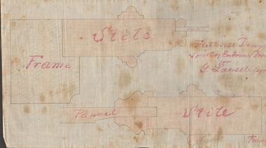
Document - MARKS COLLECTION: DRAWING ENTRANCE DOOR FOR G. LANSELL
Plan drawn on waxed paper. Written on plan 'Full size Drawing of part of entrance door for G. Lansell, Esq' Plan shows line drawings of side elevations of Frame, Stile, Pelmet, Stile, Frame. On bottom of plan purple ink stamp 'Vahland & Getzschmann, Architects, Sandhurst'.Vahland & Getzschmann, Architects, Sandhurst.bendigo, house, fortuna villa -
 Melbourne Tram Museum
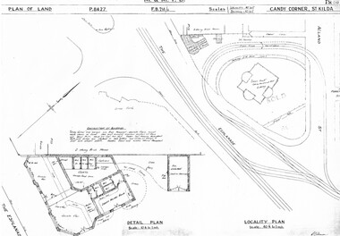
Drawing, Melbourne & Metropolitan Tramways Board (MMTB), "Candy Corner St Kilda", c1938
Set of two photocopied plans or drawings on A3 sheets of "Candy Corner St Kilda" .1 - P8427 - Plan showing locality plan, detail plan and adjacent buildings - 6-12-1938 .2 - ditto, but not the detail of the building in the centre of the island - "Green Knoll" Cafe and Amusement Park.trams, tramways, drawings, depots, property, candy corner, st kilda, turning loops -
 Federation University Historical Collection
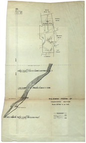
Plan, Sulieman Pasha Co Plan Transverse Section
The Sulieman Pasha is possibly named after the most important Sultan of the Ottoman Empire, Suleiman One, or Suleiman the Magnificent, when the Ottoman Empire was at its peak. Or potentially a number of Ottoman governors, statesmen and military commanders with the same name after, however the spelling is slightly different to the mine name. No Turkish connection was found relating to the formation of the company, and remains unconfirmed. The mine operated from two shafts; No. 1 near the corner of Humffray and Mair streets, and also near where the Welcome Nugget (2217 ounces) was found years earlier; and the controversial No. 2 shaft several blocks south bordering the northern side of the main highway through Ballarat. The company produced 62 666 ounces of gold, the twelfth highest quartz reef gold production for any mine on the Ballarat goldfield. Some crushing figure examples are January-June 1881: 3674 tonnes 1085 ounces; January-June 1885: 2949 tonnes 1281 ounces; July-December 1885: 4459 tonnes 1119 ounces; January-June 1887: 1869 tonnes 730 ounces; July-December 1892: 1450 tonnes 771 ounces; July-December 1896: 4365 tonnes 1372 ounces. Like many mines in the area, gold grades were low. John Watson was noted as mine manager in the 1880s, and John Williams 1890s. The company was re-organised twice increasing the number of shares from 4000 to 24 000, and increasing the capital available. The Sulieman Pasha Company was formed in 1878. David Fitzpatrick was given the honour of turning the first sod of both the No.1 and later No. 2 shafts. The first dividend was given to shareholders in July 1881. The company obtained a prospecting vote (government grant) to start, and was very proud to be the first Victorian gold mining company to pay the funds back to the government. The event was marked by a lavish banquet laid out for ministers and government officials by the company. Leases were purchased to the south in 1885 to the Llanberris Mine boundary, after poor results began accumulating from the small No. 1 shaft. To take advantage of this new land the company planned to sink a second shaft. Initially this was to take place on government land, but the uproar from nearby residents caused the company to purchase land along the Main Road (now Western Highway), and the old Yarrowee Hotel which had occupied the site since the alluvial digger days of the 1850's was demolished. The area had since those days become heavily occupied with a number of shops, houses, a post office, church and two schools in the immediate area. The thought of an underground mine next door drew considerable opposition. The company (before the days of public relations departments) wrote 'most people would have thought that progress as vital as mining would be supported by tradesmen whose business rely on the mining industry. It seems when it comes to mining they are bereft of their senses, and considering the low ebb of mining in Ballarat East, the action of our opponents are unaccountable. (Sarcastically) There are certain engineering difficulties in moving the quartz reefs to a new location, but if we could to appease our opponents we would'. The company also wanted to take over 4 acres of the St Paul's school oval for machinery, but accused the St Paul's Church of wanting extortionate amounts of money upfront, and on a yearly basis for the privilege. It stated the church could not be opposed to mining when several years earlier it had formed its own company to mine the land, only for shareholders to lose their money. In 1886, the company approached the Minister for Mines, and attended heated public meetings on the matter. The local residents, shop owners, and church submitted a 60 person petition to the local council and government authorities. They stated the shaft contravened the mining statutes, which stating no mining could take place within 150 yards of a public building or church. A speech by a resident stated 'mining always comes with glorious pictures of the great benefits which would accrue all parties concerned if their request is granted, but if property is destroyed or depreciated in value, no-one then comes forward and compensates them'. The No. 2 shaft was approved including taking over part of the school oval. In 1888, workers at the company's No. 2 shaft went on strike to try and bring their wages in line with other mines in the district (the No. 1 shaft was operated by tributers). William Madden (26) was killed from a fall of earth underground the same year, while a year later his father John Madden (70) was similarly killed in the Madame Berry Mine elsewhere in the district. In 1897 as the amount of gold being found fell away, it came to light part of the deal to purchase the Yarrowee Hotel site was a 5% royalty on gold found. Shareholders could not understand why they were paying a royalty to the former owners of the property. The mine closed in 1898 due to a lack of gold. In 1902 a boy (age unknown) called Charles Lee was killed from a fractured skull while working to dismantle the Sulieman Pasha plant. The fuss over the No. 2 shaft had a sequel. On the company winding up, the land was purchased by J.S. Trethowan who built a house next to the shaft. In 1907, the shaft caved-in creating a sinkhole immediately at the back of the house. A Mr Chamberlain heard a deep rumbling sound at 5am, and looked out the window to see his fowl house and thirteen chickens disappear down an expanding hole. He then went back to bed, and called the police later in the day. The shaft was 1050 feet deep, and the hole at the surface that developed was 20 feet by 17 feet across, and 20 feet depth. In 1930 it is reported a syndicate had been formed to clean out the old shaft, and re-open the mine. It is assumed this was the No. 1 shaft but no more was found. (https://www.mindat.org/loc-304239.html, accessed 07/08/2019) A transverse section plan of the Sulieman Pasha Mine.sulieman pasha company, plan, mining, united black hill mine, victoria united mine, victoria street, britannia united mine, last chance mine, llanberris mine, ottoman empire, john watson, john williams, david fitzpatrick -
Bendigo Historical Society Inc.
Document - MARKS COLLECTION: PLAN OF HOT WATER HEATER FORTUNA FOR G. LANSELL
Plan of hot water heater, Fortuna Villa, drawn on heavy paper. On top of plan in red ink 'Plan of Hot Water Heater for G.Lansell Esq for Fortuna Villa Sandhurst' Drawings show front, transverse, longitudinal, back and side elevations of heater, also back, side and front elevation of individual water heaters, including one with ornate screen. On bottom of document: floor plans of ground plan and basement. Plan stamped on RH bottom : William C. Vahland, Architect, Sandhurst.bendigo, house, fortuna villa -
 Melbourne Tram Museum
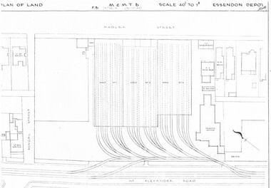
Drawing, Melbourne & Metropolitan Tramways Board (MMTB), "Essendon Depot", c1937
Set of three photocopied plans or drawings on A3 sheet of Essendon Depot - c1937 to 1944 .1 - P? - Plan showing depot block and building plan with adjacent private houses and properties - dated 30-12-1944 .2 - P8008 - Plan showing depot block and building plan with adjacent private houses and properties - dated 27-4-1937 .3 - P8089 - Detail plan of depot and offices, dated 27-4-1937 - prior to new offices being built.trams, tramways, drawings, depots, property, essendon depot -
 Melbourne Tram Museum
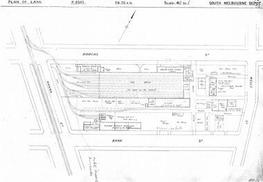
Drawing, Melbourne & Metropolitan Tramways Board (MMTB), "South Melbourne Depot", c1937
Set of five photocopied plans or drawings on A3 sheet of "South Melbourne Depot" - c 1937 .1 - P8345 - Plan of land showing MMTB land and surrounding properties. .2 - P8346 - Plan of land showing detail of offices .3 - P8347 - Plan showing detail of tram shed and adjacent buildings .4 - P8348 - Plan showing detail of buildings along the side of the block. .5 - P8349 - Plan showing details of the per way yard and associated facilities.trams, tramways, drawings, depots, property, south melbourne depot -
 Kew Historical Society Inc
Plan - Subdivision Plan, Bonnie Doon Estate, c.1908
Pru Sanderson, in her groundbreaking ‘City of Kew Urban Conservation Study : Volume 2 - Development History’ (1988), summarised the periods of urban development and subdivisions of land in Kew. The periods that she identified included 1845-1880, 1880-1893, 1893-1921, 1921-1933, 1933-1943, and Post-War Development. These periods were selected as they represented periods of rapid growth or decline in urban development. An obvious starting point for Sanderson’s groupings involved population growth and the associated economic cycles. These cycles also highlighted urban expansion onto land that was predominantly rural, although in other cases it represented the decline and breakup of large estates. A number of the plans in the Kew Historical Society’s collection can also be found in other collections, such as those of the State Library of Victoria and the Boroondara Library Service. A number are however unique to the collection.The Kew Historical Society collection includes almost 100 subdivision plans pertaining to suburbs of the City of Melbourne. Most of these are of Kew, Kew East or Studley Park, although a smaller number are plans of Camberwell, Deepdene, Balwyn and Hawthorn. It is believed that the majority of the plans were gifted to the Society by persons connected with the real estate firm - J. R. Mathers and McMillan, 136 Cotham Road, Kew. The Plans in the collection are rarely in pristine form, being working plans on which the agent would write notes and record lots sold and the prices of these. The subdivision plans are historically significant examples of the growth of urban Melbourne from the beginning of the 20th Century up until the 1980s. A number of the plans are double-sided and often include a photograph on the reverse. A number of the latter are by noted photographers such as J.E. Barnes.The subdivision advertised as the Bonnie Doon Estate in Greensborough was first advertised in 1908. At that stage, the new subdivision included 15 allotments of between one and four acres. By the time the subdivision plan in the Kew Collection was created, only 12 lots of between ¾ and 2½ acres remained. Both the State Library and Kew plans emphasise the distance to the city being 13½ miles, which could be reached by train on weekdays and weekends. Unusually, the plan describes the suitability of lots as locations for ‘Week-end Homes’. Correspondingly, the train line is described as ‘The Holiday Resort for the Northern Suburbs’.bonnie doona estate, subdivision plans - greensborough -
University of Melbourne, Burnley Campus Archives
Plan, Yates Landscape Details - Mr & Mrs Yates, 1993
Plans by John Patrick Pty. Ltd. (1) Tracing paper plan, Yates Landscape Details DRG No P9235-L3. Drawn by M.P. 12.1.93. (2) Tracing paper plan, Irrigation Plan DRG No P9235-L3. Scale 1:100. Drawn by M.P. 20.8.93. (3) Tracing paper plan, Yates Planting and Layout DRG No 9235-L1. Drawn by M.P. 6.1.93.john patrick pty. ltd., hawthorn, yates, landscape design -
Port Melbourne Historical & Preservation Society
Document - File, Port Melbourne Yacht Club, 1970s - 1990s
Port Melbourne Yacht Club .01 -Sewerage connection 1975 - including plans .02 - PMYC expansion report. Original 1976 including plans and photos .03 - Rebuilding of clubhouse 1992. Including plans sport - yachting, built environment - recreational facilities -
Whitehorse Historical Society Inc.
Document, Special Council Meeting, 1994
Special Council meeting 28 Nov 1994. Notice and agendas of meetings to be held in the Council Chamber, Civic Centre, Nunawading.Special Council meeting 28 Nov 1994. Notice and agendas of meetings to be held in the Council Chamber, Civic Centre, Nunawading. Corporate Business Special Committee, Finance Special Committee and Forward Planning Committee. Includes papers re East Burwood Reserve, Nunawading Basketball Centre, East Burwood Plaza Shopping Centre.Special Council meeting 28 Nov 1994. Notice and agendas of meetings to be held in the Council Chamber, Civic Centre, Nunawading.local government, city of nunawading, east burwood reserve, nunawading basketball centre, east burwood plaza shopping centre -
 Kiewa Valley Historical Society
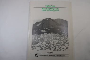
Book - Book - Alpine Area - Department of Conservation, Forests & Lands, Alpine Area / Planning Proposals / a basis for management. 1987
It is the policy of the Government that most of the State's alpine area will be proclaimed as an Alpine National Park, which would complement the Kosciusko National Park in N.S.W.. This is yet to be achieved (1987), however there is a need for sound, efficient and coordinated management based on the area's natural features, values and uses. Planning is proceeding on this basis.Victoria's alpine area is one of the State's most outstanding and spectacular natural areas. It is noted for its diverse plant and animal life, scenery, recreation opportunities and as a water catchment. This country is at the upper end of the Kiewa Valley and the planning for it is of interest to the Kiewa Valley inhabitants.White bound book with green print for title at the top, black & white picture and black print at the bottom for the name of the government authority publishing the book.143 pages with fold out map after page 7. The map is coloured green to indicate the planning area.alpine area, bogong national park, victorian department of conservation forests & lands -
Federation University Historical Collection
Photograph, Technical Drawings, 07/11/1990
Examning plans for library revdelopmentbryan miller, shirley falkinder, john thomas, john sharpham -
 Greensborough Historical Society
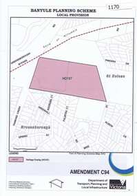
Map, Saxam Heritage Overlay, 2011_
"Saxam" was the home of the Kaye family (1886-1888) then William Santon, a former councillor and Mayor of Heidelberg. Saxam Homestead is a distinctive and substantial timber homestead built in the late 1880s as one of the notable rural properties in the St Helena area. In 2014 the house still stands but is in poor condition with most interior features removed. The site had a heritage overlay as shown. The overlay was reduced in 2014 to protect the house while allowing residential development on the site.Saxam is one of the only remaining farmhouses in the Greensborough area.Copy of map and planning scheme.saxam -
Ringwood and District Historical Society
Envelope, Packet: City of Ringwood planning reports 1990s
City of Ringwood planning reports -
 Federation University Historical Collection
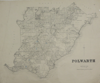
Plan, Polwarth, 1927, 1927
Printed plan with hand colouringotway, polwarth, cape otway -
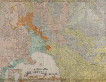 Federation University Historical Collection
Map, Geological Map of Ascot, 1937, 1937
Coloured plan of Melbourne and suburbs.melbourne, geological, geology, caulfield, brighton, box hill, camberwell, richmond, prahran, st kilda, brunswick, coburg, keilor, braybrook, kew, hawthorn, northcote, williamstown, south melbourne -
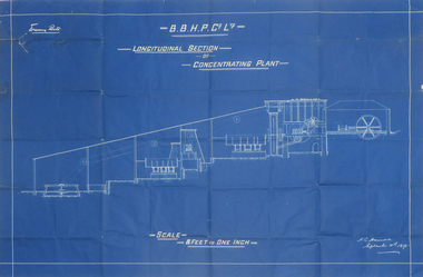 Federation University Historical Collection
Plan, Blueprint B.B.H.P. Co Ltd Longitudinal Section of Concentrating Plant, 1895
Blueprint plan by H.L. Hancock blueprint, h. l. hancock, longitudinal section, concentrating plant, bhp -
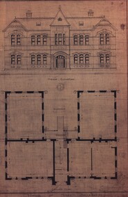 Federation University Historical Collection
Plan, School of Mines, Ballarat: Front elevation plan for new building, 1899, 1899
Mounted photocopy of plans for 1899ballarat school of mines, plan, front elevation, new classrooms, administration building, a building, architectural drawing -
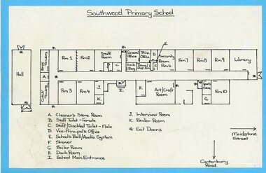 Ringwood and District Historical Society
Plan, Sothwood Primaty School floor plan
Floor plan of Southwood PS -
 City of Moorabbin Historical Society (Operating the Box Cottage Museum)
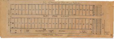
Plan - Ormond Garden Estate, Ormond, 1920
At the end of World War One, there was a renewed interest in residential land and a number of estates opened up in the Municipality of Moorabbin. Ormond Garden Estate was auctioned on Saturday 10 April, 1920.Example of the progress of the Municipality of MoorabbinHand drawn plan of subdivisionOrmond Garden Estatenorth road, glen orme avenue, murray road, ormond, auction, real estate -
 City of Moorabbin Historical Society (Operating the Box Cottage Museum)
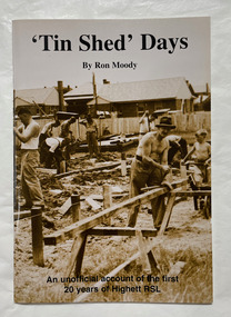
Book, Moody, Ron, 'Tin shed' days, 1997
An unofficial account of the first 20 years of Highett RSL.44 p. : plans, ports. ;non-fictionAn unofficial account of the first 20 years of Highett RSL.highett, highett rsl, returned services league of australia -
Port Melbourne Historical & Preservation Society
Document - Community Service Planning, Beris Campbell Collection, 1974 - 1993
Collection of files from Beris CAMPBELL; Port's first Social Worker. Includes local newspapers, flyers and reportsCommunity Service Planning 1992local government - city of port melbourne, health - general health, politics, public action campaigns, port melbourne citizens action group, port melbourne social welfare centre, city of south melbourne, beris campbell -
Port Melbourne Historical & Preservation Society
Plan - Pathworks, Heath Street, Port Melbourne, Borough of Sandridge, 16 Feb 1861
Plan - Pathworks Heath StreetFrederick Wm. Bull Municipal Surveyor Sandridgeengineering - roads streets lanes and footpaths, frederick william bull -
 Monbulk RSL Sub Branch
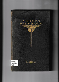
Book, Australian War Memorial, Guide to Australian War Memorial, 1941
An early guide to the Australian War MemorialIll, plans, p.107.non-fictionAn early guide to the Australian War Memorialwar memorials - australia - guidebooks, australian war memorial -
University of Melbourne, Burnley Campus Archives
Document, Additions, repairs, fencing and painting at School of Horticulture and Primary Agriculture Burnley, 1991
Tender documentation incl. plans -
University of Melbourne, Burnley Campus Archives
Document, Amenity Horticulture Orientation Walk, 1980-1990
Description of areas of Burnley with a planamenities, horticulture, burnley -
Whitehorse Historical Society Inc.
Map, Britannia Rise, 2012
Photos and plans of Britannia Rise.Photos and plans of Britannia Rise.Photos and plans of Britannia Rise.britannia rise', whitehorse road mitcham, no 569-571, mitcham railway station, eastlink, britannia mall, kenneth jones real estate