Showing 177209 items matching "27-schutt-street"
-
 St Kilda Historical Society
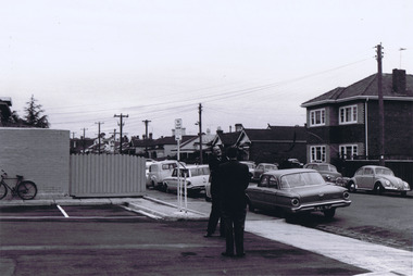
Photograph, Camden Street carpark, Balaclava, 11/1962
Opening of carpark Camden Street Balaclava black and white photograph, unmounted, original, good conditionOn back: Car Park opening Camden Street Nov 1962 From Leete Chemist -
 Stawell Historical Society Inc
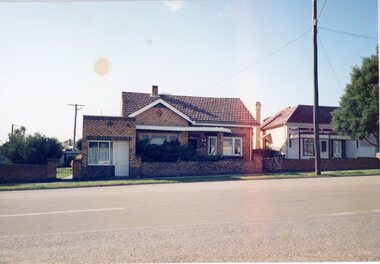
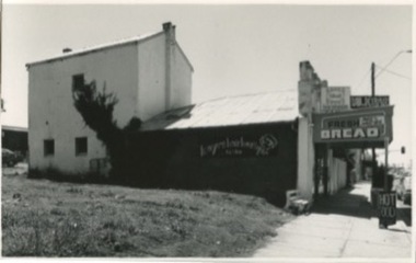
Photograph, 39 Main Street
39 Main Street: Mr Tom Healy did boot & shoe repairs from shop at front of house.Colour Photgraph. Brick home with brick fence. Small brick building opening onto footpathOn reverse: Shop where Tom Healy worked in Lower Main Streetbusiness, tom healy -
 Surrey Hills Historical Society Collection
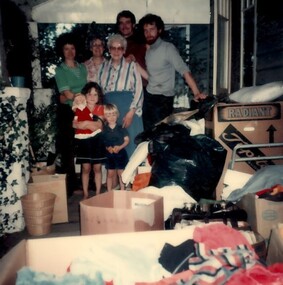
Photograph, 9 Vincent street, Surrey Hills
A colour photo of part of the interior of Mrs Mayer's house at 9 Vincent Street, Surrey Hills. It includes 3 women of varying ages, 2 men and 2 children, a boy and a girl. There are many boxes. at 9 Vincent st / Mrs Mayer's hospitality - / she was 80 y.o. / on her verandah / Pete[?] and Mike / & 2 chn there / for a fortnightwomen, children, men, verandah, boxes, toys, architectural features, personal effects -
 Kilmore Historical Society
Photograph, 5 Sydney Street, 2001
Connected with items: PHO-00010, PHO-00011 and PHO-00012.15cm x 10cm colour photograph of the cottage at the rear of Kilmore Communications, 5 Sydney Street. Printed on glossy photograph stock Konica brand. 2 photos included offering differing views of the property.Written on the back: Photo 1: Cottage at rear Former Kilmore Free Press Office 2001 5 Sydney St Photo: Heather Knight Photo 2: 5 Sydney St Cottage at rear shop - Kilmore Communications, former Kilmore Free Press Office. West side Sydney St, Kilmore, Opposite Husdon Park 2001 Photo: Heather Knight.real estate agents, cottages -
 Kew Historical Society Inc
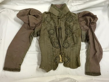
Clothing - Two Piece Grey Silk Dress, Peter Robinson, 1890s
The Fashion & Design collection of the Kew Historical Society includes examples of women’s, men’s, children’s and infants’ clothing from the 18th, 19th and 20th centuries. Items in the collection were largely produced for, or purchased by women in Melbourne, and includes examples of outerwear, protective wear, nightwear, underwear and costume accessories.This outfit was donated by Netta Fuller.Two piece grey silk outfit comprising a tailored bodice and a very full skirt. The bodice has puffed leg-of-mutton sleeves and is heavily encrusted with large grey artificial pearls and steel beads of the period. The skirt is cut to allow for a long train at the back. Grey pearls and steel beads are similarly used on the right side of the front of the skirt. Metallic braid may have been added at a later date. The outfit has been much altered over time. There is evidence of shattered silk in parts of the garment. Printed on a strap at the waist is the label of Peter Robinson, Oxford Street/Regent Street.Peter Robinson. Oxford Street/Regents Streetwomen's clothing, women's fashion -- 1890s, peter robinson, international fashion, fashion -- united kingdom, fashion design, fashion -- 1890s -
 Marysville & District Historical Society
Document (Item) - Information document, Victorian Bushfire Reconstruction and Recovery Authority, Marysville - Murchison Street and Town Amenity Project, 2010
A document outlining the re-building and re-development of Murchison Street in Marysville in Victoria.A document outlining the re-building and re-development of Murchison Street in Marysville in Victoria.marysville, victoria, 2009 black saturday bushfires, murchison street -
Marysville & District Historical Society
Document (Item) - Research Document, Rene de Koning, Lyell Street Named After Charles Lyell (1797 - 1875), 13-08-2022
An account of the life of Charles Lyell whom Lyell Street in Marysville in Victoria is named for.An account of the life of Charles Lyell whom Lyell Street in Marysville in Victoria is named for. Charles Lyell was a Scottish geologist who demonstrated the power of known natural causes in explaining the earth's history.charles lyell, lyelll street, marysville, victoria -
Marysville & District Historical Society
Document (Item) - Research Document, Rene de Koning, Sedgwick Street Named After Adam Sedgwick (1785 - 1873), 13-08-2022
An account of the life of Adam Sedgwick whom Sedgwick Street in Marysville in Victoria is named for.An account of the life of Adam Sedgwick whom Sedgwick Street in Marysville in Victoria is named for. Adam Sedgwick was a British geologist and Anglican priest, one of the founders of modern geology. He proposed the Cambrian and Devonian period of the geological timescale. Based on work which he did on Welsh rock strata, he proposed the Cambrian period in 1835, in a joint publication in which Roderick Murchison also proposed the Silurian period. Later in 1840, to resolve what later became known as the Great Devonian Controversy about rocks near the boundary between the Silurian and Carboniferous periods, he and Murchison proposed the Devonian period. adam sedgwick, sedgwick street, marysville, victoria -
 Ringwood and District Historical Society
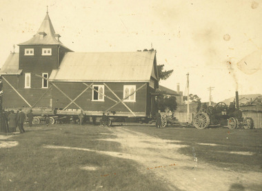
Photograph, Moving Ringwood's Church of England Church from Pratt Street to Ringwood Street - 1924, 1924
Moving Church of England Church from Pratt Street to Ringwood StreetTyped below photograph, "Moving Church of England Church from Main St. Cnr. Pratt St. to Cnr. Ringwood St. and Civic Place - 1924" -
 Ballarat Heritage Services
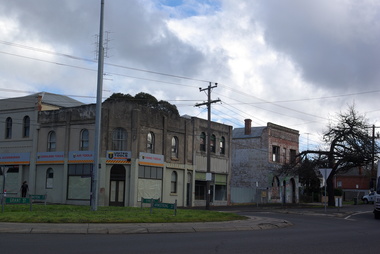
Photograph - Colour Photorgraph, Buildings on the Corner of Armstrong Street South and Eyre Street, Ballarat, 13/08/2020
Colour photograph on the corner of Armstrong Street South and Eyre Street, Ballaratballarat buildings, eyre street ballarat, armstrong street south -
 Eltham District Historical Society Inc
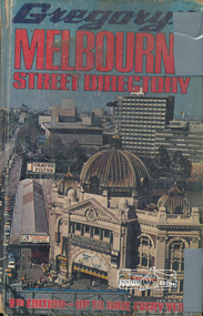
Book, Gregory's Melbourne Street Directory of Melbourne and suburbs and metropolitan road guide (8th edition) extends to Laverton, Deer Park, Epping, Diamond Creek, Lilydale, Olinda, Belgrave, Doveton and Mornington, 1973
This is the 8th edition of Gregory's Melbourne Street Directory, fully revised and up-to-date for this edition published December 1973. It is a comprehensive guide to the streets and localities of Melbourne and suburbs at that time. The colour maps are arranged in double-page spreads. Names of streets and suburbs are arranged alphabetically in the index to streets.Hard copy with plastic cover. 382 p. streets, melbourne - maps, roads -
 Glen Eira Historical Society
Album - Album page, "Ripponlea", Hotham Street, Circa 1972
This photograph is part of the Caulfield Historical Album 1972. This album was created in approximately 1972 as part of a project by the Caulfield Historical Society to assist in identifying buildings worthy of preservation. The album is related to a Survey the Caulfield Historical Society developed in collaboration with the National Trust of Australia (Victoria) and Caulfield City Council to identify historic buildings within the City of Caulfield that warranted the protection of a National Trust Classification. Principal photographer thought to be Trevor Hart, member of Caulfield Historical Society. Most photographs were taken between 1966-1972 with a small number of photographs being older and from unknown sources. All photographs are black and white except where stated, with 386 photographs over 198 pages.From Victorian Heritage Database citation for Rippon Lea H0614 https://vhd.heritagecouncil.vic.gov.au/places/427(as at 23/10/2020) Rippon Lea was commenced in 1868 by Frederick Sargood, a most successful politician and merchant. He was born in England in 1834 and arrived in Melbourne in 1850. He soon joined his father's wholesale soft goods firm, spending some time as its manager on the goldfields. Sargood entered the Legislative Council in 1874. He was Victoria?s first Minister for Defence in 1883. Sir Frederick Sargood was created CMG. In 1885 and KCMG in 1890 as a reward for his contribution to public life. He died suddenly in 1903. Rippon Lea was designed by the leading firm of architects, Reed and Barnes. Joseph Reed had travelled in Europe in 1863, including northern Italy. When he returned he introduced the use of polychromy. While not the first examples, Rippon Lea and the Independent Church in Collins Street were the best and set a fashion which became a distinctly Melbourne style, particularly used for houses and churches. Its popularity was possible because of the new availability of different coloured bricks. Reed's fine Lombardic Romanesque details soon became debased by others. As Sargood's family grew and his fortunes prospered, Rippon Lea was extended to include 33 rooms - a complete mansion. The cast iron porte cochere and the northern conservatory were added in 1897. The architects were Taylor and Fitts. The ballroom was added in 1882 and remodelled in 1889. Many alterations have changed the interior and exterior during the ownerships of Benjamin Nathan and later his daughter Mrs Louisa Jones in the 1930s and are in their own right of significance. Sir Thomas Bent owned the property from 1903 until 1911 but never lived there. He subdivided much of the land. The original garden dates from about 1868, and it seems that William Guilfoyle of the Botanic Gardens was involved. It was redesigned in a more natural style in the 1880s by Sargood and his head gardener, Adam Anderson. The lake, waterfalls, fernery, hill and grotto are balanced by mighty deciduous trees and conifers. These are interspersed with, but never dominated by Australian species such as eucalyptus and other exotics. The sinuous drive with its carefully prepared approach to the house is notable. The original vegetable gardens, orchard and outer paddocks no longer survive. The shade house is important as the largest known in Australia and possibly the world. Its curved plan and form of construction are particularly notable. It was built about 1884.Page 94 of Photograph Album with four photographs (three landscape and one portrait) of Ripponlea - stables, lookout and neighbouring cottages.Handwritten: "Ripponlea" Hotham Street [top right] / Neg 256 Dec 1972 STABLES [under top left photo] / Neg 248 Dec 1972 LOOKOUT [under top right photo] / Neg 254 Dec 1972 / COTTAGES WILLOW STREET [under bottom left photo] / Neg 259 Dec 1972 STABLES [under bottom right photo] / 94 [bottom right]trevor hart, elsternwick, mansion, hotham street, frederick sargood, reed and barnes, 1860's, 1890's, 1880's, benjamin nathan, nathan, louisa jones, thomas bent, sir thomas bent, william guilfoyle, guilfoyle, adam anderson, ripponlea, victorian, sir frederick sargood, architects, bricks, polychrome bricks, taylor and fitts, stables, lookouts, cottages, outbuildings, rippon lea -
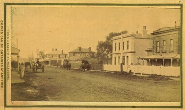 Bacchus Marsh & District Historical Society
Photograph, Main Street Bacchus Marsh 1883 looking east
View of Main Street Bacchus Marsh 1883, showing early notable buildings on the southern side of the street, including the Courthouse, National Bank of Australasia, Border Inn, Hall of Commerce building. Small sepia unframed photograph on card with gold border framing photograph. Housed in the album, 'Photographs of Bacchus Marsh and District in 1883 by Stevenson and McNicoll'. Several horse-drawn vehicles can be seen travelling along an unmade road. Piles of excavated dirt can be seen along the side of the road. Four substantial two-storeyed buildings can be seen along the southern side of the street.On the front: Stevenson & McNicoll. Photo. 108 Elizabeth St. Melbourne. COPIES CAN BE OBTAINED AT ANY TIME. On the back: LIGHT & TRUTH inscribed on a banner surmounted by a representation of the rising sun. Copies of this Portrait can be had at any time by sending the Name and Post Office Money Order or Stamps for the amount of order to STEVENSON & McNICOLL LATE BENSON & STEVENSON, Photographers. 108 Elizabeth Street, MELBOURNE. stevenson and mcnicoll 1883 photographs of bacchus marsh and district, bacchus marsh roads and streets, bacchus marsh main street 19th century -
Hume City Civic Collection
Print - Street Directory, Gregory"s Melbourne Street Directory, c1972
This street directory was published by Gregory's Guides & Maps Pty Ltd of 142 Clarence Street, Sydney NSW in c1972. It was used by the donor's family for many years to navigate their way around Melbourne and the metropolitan area. A street directory enclosed in a black leather detachable cover with gold embossing of a car on the front cover.Gold embossed vintage car on front of detachable cover.joan houston, streets, roads, maps, street directory -
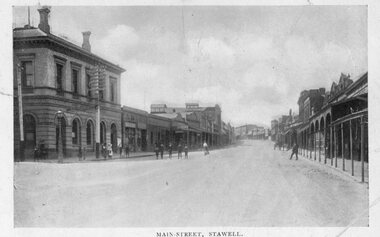 Stawell Historical Society Inc
Photograph, Main Street Stawell -- Postcard
Pre Motor Vehicle Street Scape. Gas Light and Telephone pole in front of Post Office.B/W. Main Street. Post.Office. up people - 1 man crossing road in front of card, woman is riding a bicycle up the steet. A group o fmen in front of Post Office another on the Street.Ajax Series POSTCARD Address Only -
Federation University Historical Collection
Plan, University of Ballarat Camp Street Precinct, 2000, c2000
The university aspect of the Camp Street Precinct was named the arts AcademyFramed plans of the Univesity of Ballarat (later Federation University) Camp Street Precinct. .1) Drawing of elevations for the university of Ballarat and the City of Ballarat Camp Street Precinct elevations including a new performing arts Building, Mining Exchange, Visual Arts Building, and Alfred Deakin Place. .2) Camp Street Precinct elevations including the Ballarat Post Office, State Offices and Old Courthouse. camp street, camp street precinct, plans, daryl jackson, arts academy -
 Eltham District Historical Society Inc
Photograph, Russell Yeoman, Looking south from Swan Street, Eltham, c,1965, 1965c
Shows Susan Street, Brisbane Street and Bridge Street. Large open field in centre now site of Bunnings The factory in lower centre on Brisbane Street is the Sibbel Builders factory of Martin and Herman Sibbel who were ahead of their time with design and prefabricated frames and also built cabinetry in this factory.Digital file only; created from original colour positive slide transparencyeltham, streets, susan street, bridge street, brisbane street, bunnings, ses, state emergency service, herman sibbel, martin sibbel, sibbel builders -
![Borough of Kew - Gazetted Streets [1865-1937]](/media/collectors/550653872162f11fb04854aa/items/59614050d0cdd511a09c84a0/item-media/59614577d0cdd511a09e80c0/item-fit-380x285.jpg) Kew Historical Society Inc
Kew Historical Society IncDocument, Borough of Kew / Gazetted Streets, 1865-1937
The Melbourne suburb of Kew gained independence from the Boroondara Roads Board in 1860, being declared a Municipality in that year. Kew became a Borough in 1863, a Town in 1910, and a City in 1921. The former City of Kew became part of a newly declared City of Boroondara in 1994. This very fragile document records the following information about streets in Kew - Name, Total Width, Width of Carriageway, Description, Government Gazetted - Year & Page.While the name of a street was formally acknowledged and published in the Victorian Government Gazettes, this document, compiled by a public officer, probably in the Town Clerk's Department, is the earliest known local record listing street names in the Borough, later Town, then City of Kew. The front page indicates that in 1865, the responsibility for an initial 36 streets in Kew was taken over by Council. The final annotation in the document was made in 1937. The document is an important record for researchers seeking to understand the dating of streets in the district.27-page document compiled by officers of the Borough, Town and City of Kew, listing the names of streets taken over by Council, and providing details of their proportions and gazettiing. The document covers the period of 1865 to 1937. Handwritten documentborough of kew, streets -- kew (vic.) -
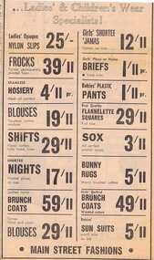 Greensborough Historical Society
Advertisement - Digital image, Diamond Valley News, Main Street Fashions, 1964, 29/09/1964
Advertisement for Main Street Fashions, women's and children's wear, Main Street, Greensborough 1964Digital copy of newspaper advertisement.main street fashions, main street greensborough -
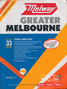 Eltham District Historical Society Inc
Book, Melway Publishing, Melway Greater Melbourne street directory : including Geelong, Phillip Island, Healesville, Kinglake, Gisborne, Lorne, Wallan, Bacchus Marsh Bellarine & Mornington Peninsulas; Edition 33, 2006, 2005
Edition 33. 2006 Coloured detailed maps accessed by a street or location index. Cover: Totally revised and updated with over 1380 new street listings new maps covering Mount Duneed on the Bellarine Peninsula, Pakenham South and Rythdale. Detailed public transport routes - train, tram, bus, bicycle paths & shared road routes. Eastlink fully detailed new Craigieburn bypass GPS compatible WGS/MGA Grid Special feature: New Hierachy of Roads Street directory with plastic cover, coloured maps, 902 pagesstreets,roads,melbourne,map,melway -
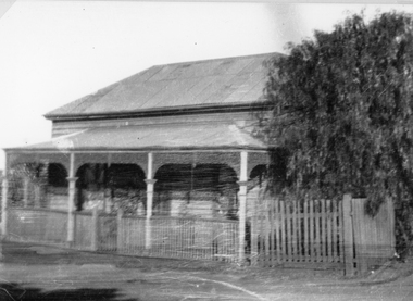 Stawell Historical Society Inc
Photograph, Upper Main Street Stawell with a Weatherboard Home – Reeve Family
The Photgraph of a Weatherboard Home which was situted Upper Main Street on the left side of the street– It was the home of the Reeve Family. Black and White photgraph of a weatherboard home with veranda across the front, around which a wooden fence and gateway, onto the street.stawell, reeve -
 Eltham District Historical Society Inc
Slide, Beard Street intersection with Main Road, Eltham, Nov. 1981
Roll of film taken by Eltham Shire Council officers (Nov. 1981) reflecting road infrastructure.35 mm colour positive transparency (1 of 27) Mount - Kodak Ektachrome CardProcessed 18 Jan 1982infrastructure, main road, roads, beard street -
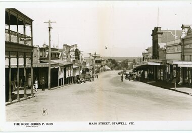 Stawell Historical Society Inc
Photograph, Main Street Stawell looking west towards the Post Office Rose series 1639
This photograph is of Main Street Stawell lookingwest around c 1930's. The photo was taken from the Bull and Mouth Hotel whis is on the left side and other business. On the road are a few people and cars.Black and white Postcard Rose Series 1639 Looking down Main St From the Bull and Mouth Hotel Partially visable on the left. The Rose series, P 1639 Main Street, Stawell, Victoriastawell business shops streetscape -
 Bacchus Marsh & District Historical Society
Map, Main Road and Gell Street Allotments
This map shows allotments of land along Gell Street Bacchus Marsh running between Main Road (now called Main Street) and Lerderderg Street. The total area of the map encompasses Main Road, Church Street, Lerderderg Street and Gell Street. 36 allotments of land are shown. Three allotments which connect to Main Road are shaded in pink. The date of the map has not been established but the National Bank building erected in 1865 near the Border Inn is indicated which indicates that the map dates from after 1865. Reports in the Bacchus Marsh Express newspaper on 5 March 1870, page 2, column 6 announced building lots in Gell Street had been withdrawn from sale by the agent J.E. Crook. Later reports in the Express on 1 November 1873, page 2, column 2 advertised 14 allotments of land in Gell Street for sale. Single page map showing allotments of land along the Main Road (Main Street) and Gell Street areas of Bacchus Marsh. Part of a set of maps which are pasted into a bound volume containing 76 maps or plans in total. High resolution digital image stored on BMDHS computer network. bacchus marsh victoria maps, gell street land allotments, main street land allotments -
 Kilmore Historical Society
Photograph, 13 Sydney Street, 1970's
Was the site of J. Quinn Bakery.20cm x 12.5cm black and white photograph of the Breakells Bakery and shop at 13 Sydney Street. This photo was taken from the south side of the building. Pictured is the shopfront, the outside of the single story shop building and a light coloured two story building in a the back of the shop building. On the side of the building advertising for "Kayes Hair Boutique". At the front of the shop there is a sign for "Hot Food". And on the awning of the shop there are multiple signs including: "Milkbar", "Streets ice cream" and "Fresh bread, pies & pasties". Printed on standard card stock.Written on the back: 486 14-86-35bakers, baker and bakeries, bakeries, 1970's -
 Greensborough Historical Society
Photograph - Digital Image, Marilyn Smith, Were Street Christmas celebrations 2018. Father Christmas, 2018_12
The 2018 Christmas celebration in Were Street Montmorency. In this photo Father Christmas is ready to go to Were Street.Digital copy of colour photograph.were street montmorency, were street montmorency christmas 2018 -
 Ringwood and District Historical Society
Photograph, Charter Street Ringwood Street Scenes 1981 (3 photos)
Street Scenes, Charter Street Ringwood, 6/6/1981 (3 photos)Written on back of original photos "6/6/81. Charter St. looking west from opposite no.40."; "No 40 Charter St", "No 42 Charter St" -
 Ballarat Heritage Services
Photograph, Clare Gervasoni, Brick Building on the Corner of South Street and Skipton Street, Ballarat, 2020, 13/04/2020
Colour photograph of a Brick Building on the Corner of South Street and Skipton Street, Ballarat.ballarat, south street, cast iron -
 Federation University Historical Collection
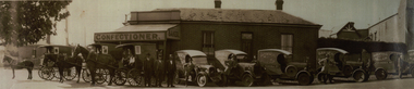
Photograph - Photograph - Black and White, Davies the Baker and Confectioner, 47 Eureka Street, Ballarat East, c1930, c1930
John Davies ran the bakery until 1923, at which time his son, Fred “F.T.” Davies, became proprietor. The business continued to grow under Fred, who turned it into one of the most successful industries in Ballarat. Fred fitted the bakery with a Perkins Continuous Oven, which was quite revolutionary for the time. The bakery was also fitted with Scotch ovens, which were used for ordinary bread-baking, and were worked manually. (https://bih.federation.edu.au/index.php/Davies_Bread)A number of horse drawn carriages, and motor vans in front of a building at 47 Eureka Street known as Davies the Baker. The three men standing together are Frederick Talbot Davies, John Davies and Hector Godfrey Smith (foreman). davies, davies bread, davies the baker, eureka street, horse, horse drawn carriage, confectioner -
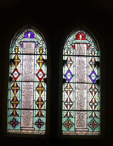 Ballarat Heritage Services
Photograph - Photograph - Colour, Stained Glass Windows in Lydiard Street Uniting Church, Ballarat, 14/02/2009
Two colour photographs of World War One memorial stained glass windows in the Lydiard Street Uniting Church. Three windows are dedicated to those who volunteered for service and returned, the fourth commemorates those who fell. stained glass, lydiard street uniting church, world war one memorial, honour roll, architecture