Showing 1113 items matching "beach road"
-
 Port Fairy Historical Society Museum and Archives
Photograph
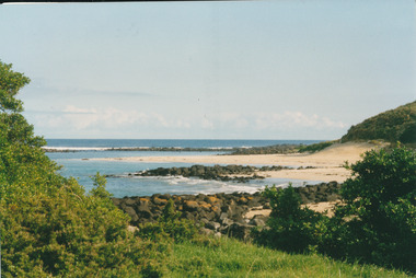
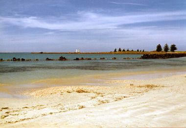
Coloured photograph of beach and bayocean, sea, rocks, bluestone -
 Port Fairy Historical Society Museum and Archives
Photograph
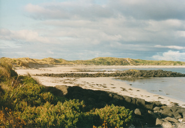
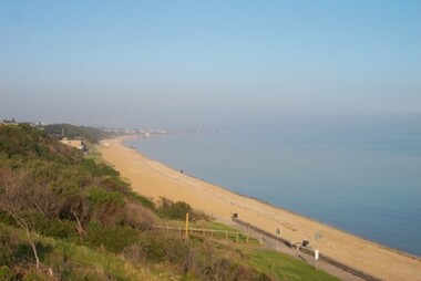
... Street Port Fairy great-ocean-road South Beach south beach ocean ...South BeachColoured photograph of South beach bay south beach, ocean, sea -
 Port Fairy Historical Society Museum and Archives
Photograph - Digital copy
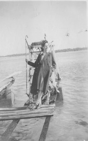
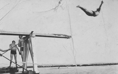
... Street Port Fairy great-ocean-road South beach diving board 1944 ...South beach diving board 1944south beach, diving, board, 1944, woman, female, lady -
 Port Fairy Historical Society Museum and Archives
Photograph - Digital copy
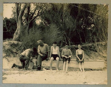
Lex Goldie standing on the diving board at the South beachlex goldie, diving, board, south beach, ocean, sea -
 Port Fairy Historical Society Museum and Archives
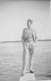
Photograph - Digital copy, 1944
Lex Goldie diving from South Beach diving board in 1944Black and white photograph of the diving board with 2 males standing and one divinglex goldie, diving, board, south beach -
 Port Fairy Historical Society Museum and Archives
Photograph
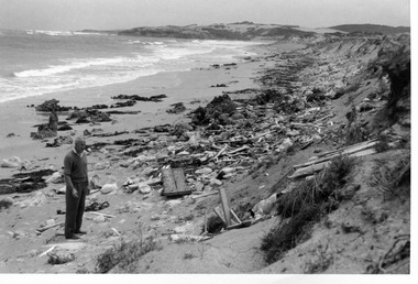
West of Crags On Yambuck beach crags, craigs, yambuk beach, flotsam, rubbish -
 Port Fairy Historical Society Museum and Archives
Photograph
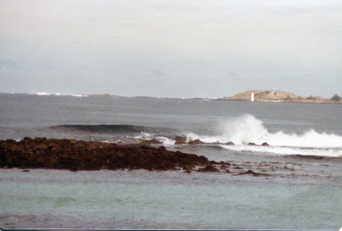
... Street Port Fairy great-ocean-road East beach from reef east ...East beach from reefplus photographic copyeast beach, sea, ocean, reef, sand, waves -
 Port Fairy Historical Society Museum and Archives
Photograph
... Street Port Fairy great-ocean-road East beach near battery hill ...East beach near battery hill sails of a tall ship in distance Coloured photograph of the East Beach with the lighthouse and a tall ship in the backgroundeast beach, ship, ocean, sea -
 Port Fairy Historical Society Museum and Archives
Photograph
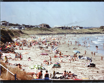
... Street Port Fairy great-ocean-road East beach with the summer ...East beach with the summer crowdseast beach, crwod, sea, ocean -
 Port Fairy Historical Society Museum and Archives
Postcard
... Road to the East beach probably Bourne Avenue...Road to the beach Port Fairy... Street Port Fairy great-ocean-road Road to the East beach ...Road to the East beach probably Bourne AvenueRoad to the beach Port Fairyeast beach, bourne avenue, tea teee -
 Port Fairy Historical Society Museum and Archives
Photograph
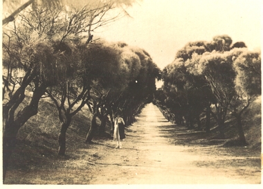
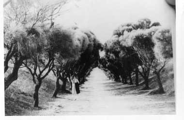
... Street Port Fairy great-ocean-road Beach avenue Road street ...Beach avenueroad, street, avenue, trees, female -
 Port Fairy Historical Society Museum and Archives
Functional object - Spoon
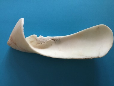
found on the East Beach Port Fairy in the early 1980's by .......Tredinnick when beach combing.Thought to be Aboriginal.a spoon shaped from a large shell- possibly from Cybiolista jansae volutidaeeast beach, shell, spoon, port fairy, aboriginal -
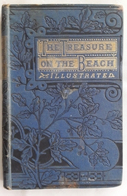 Mont De Lancey
Book, M.A.P, The Treasure on the Beach and What it did for Gilbert West, c late 1800's
A young boy finds what he thinks is treasure when he walks along the beach near his home. The story has religious themes and depicts family life in England in the late 1800'sSmall blue hardcover children's book - The Treasure on the Beach and what it did for Gilbert West by M.A.P. The front cover has a black floral design which continues onto the spine and the back, with the title surrounded in gold boxes and the word, Illustrated, in gold lettering underneath. On the back is a symbol for the publisher Sunday School Union. Black and white illustrations throughout with one on the frontispiece of Gilbert West on the beach. Black and white illumination style lettering is used for the first word of each new chapter. Tissue paper covers the title page. 107p.fictionA young boy finds what he thinks is treasure when he walks along the beach near his home. The story has religious themes and depicts family life in England in the late 1800'schildren's fiction, family life fiction, adventure stories -
 Melton City Libraries
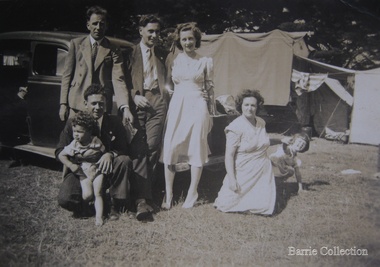
Photograph, Edna and Bon's family camp trip at Apollo Bay, 1948
Wendy Barrie's memories of Apollo Bay The camping trips were a yearly event after the harvest had finished. The trip down to the beach was a much-anticipated event heading out through Parwan and to Geelong leaving behind the hot and dusty plains and our parents relieved to have the hard work of harvesting left behind. The Otways in the distance were reached with great anticipation, Mum in the car and Dad in the Truck ahead of us anxiously winding through the narrow roads and negotiating the hairpin bends and breathing in the cool fresh air of the forest, and keeping an eye out of the log trucks that might come sweeping the corner. The tree ferns with their dripping moisture and the giant trees and the unmistakeable small of the eucalypts. Great excitement was when we caught our first view of the sea from the highest point of the road and then is was the cautious drive the sea level to the sight of the blue ocean with the white of the waves crashing on the rocks and the pristine sand. The water from the Wild Dog and Skenes creek trickling onto the ocean. The tree ferns with their dripping moisture and the giant trees and the unmistakeable smell of the eucalypts. The return journey was usually taken on the Great Ocean Road, it was considered safer to be on the inside of the road. In the early days it was very narrow and passing oncoming cars was taken very cautiously. Landslides and floods sometimes meant we would take the inland route. One year the bridges were washed away and bailey bridges were erected to keep the road open. Rock falls off the cliffs were common Stops on the way home gave us our last chance for our feet in the sand and a swim in the ocean. By the time we reached the hill at Angle Sea the vast blue ocean was behind us and we trekked back through Geelong- Bacchus road and the plains of stubble and the dry grass, and sometimes evidence of burnt patches from a bush fire. The closest we came to a pool at home was the concrete sheep trough at the gate to the work sheds. It was filled with bore water pumped from the nearby windmill. Edna, Bon and their family members at their camp site in Apollo Baylocal identities -
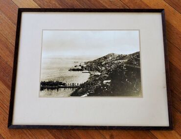 Camberwell RSL Sub-Branch
Photo, Framed photo of Anzac Cove taken in July 1915, 1915
Actual photo of Anzac Cove taken in July 1915UniqueActual photo taken at Anzac Cove in July 1915 showing the piers constructed to offload supplies and storage dumps on beach.See photo for many details -
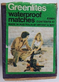 Mont De Lancey
Container - Matchbox
A Bryant & May Greenlites matchbox containing wooden waterproof matches. The front of the box has the name Greenlites waterproof matches printed in white and black lettering on a green background with an illustration of a man and a woman boiling a billy on an open fire at the beach. There are worn striking surfaces on each side. The box is covered in purple paper.Greenlites waterproof matches E2994 Contents 47 Made in Australia by Bryant & Maymatches, matchboxes, safety matches, cases -
 Mont De Lancey
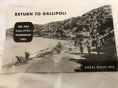
Pamphlet, 1965
Black and White printed pamphlet with yellow coloured pictures inside."Return to Gallipoli RSL-RSA Gallipoli Pilgrimage 1965 Anzac Beach 1915"pamphlets -
 Mont De Lancey
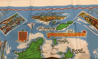
Functional object - Tablecloth
A square, souvenir tablecloth from the Channel Islands. On an azure background, all the islands are printed and named on the tablecloth, as well as the names of the towns, villages and the bays of both Jersey and Guernsey. There are four rectangular pictures, surrounded by a white border, representing significant places and buildings, as well as others, without borders, depicting old and modern ships, a compass, a coat of arms and the distinctive Jersey and Guernsey cow.There is a red and white border, almost at the edge of the azure background and in each corner is printed a white anchor and rope. There is also a 3 cm. plain white outer border around the tablecloth.Names of places, beaches and bays on the Channel islands. Pictorial representations of significant places and buildings and a white anchor and rope in each of the four corners. "Exclusive to Creaseys of Guernsey" is printed at the bottom left hand corner of the tablecloth.table ware., household textiles., table linen. -
 Phillip Island Conservation Society Inc.
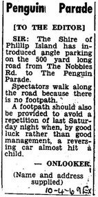
Work on paper - Photocopy of newspaper cutting, Editor, Wonthaggi Express newspaper, "Penguin Parade [TO THE EDITOR]", 10. 04.1969
This letter to the editor of the Wonthaggi Express newspaper was written by “ONLOOKER (name and address/supplied)” in 1969 at a time when the Phillip Island Penguin Parade was under the management of the Phillip Island Shire Council. There was very limited parking at the Penguin Parade at that stage, and visitor numbers on any night were not capped. It was not uncommon for many cars to be parked along the main road leading to the Penguin Parade. This was a cause of a great deal of concern as visitors to the Parade walked back to their cars in the dark along the main road after the Parade finished some hours after sunset. At that time there was no designated Phillip Island newspaper, with the Wonthaggi Express also covering some news from Phillip Island.The letter articulates the concern felt by many local residents and visitors to the Penguin Parade with regard to the lack of parking and other infrastructure for tourism on Phillip Island, and the Phillip Island Penguin Parade in particular. Having been published in the Wonthaggi local newspaper of the time, the Wonthaggi Express, also indicates that either there was no local newspaper being published on Phillip Island, or that the author submitted to both local newspapers in order to get their message across.Single column letter to the editor in 3 short paragraphs. Black ink on white paper. Photocopy of original article. 10-4-69 EX (referring to 10th April 1969, Wonthaggi Express newspaper)phillip island penguin parade, letter to the editor, parking problems, wonthaggi express newspaper, phillip island conservation society historical archive -
 Phillip Island Conservation Society Inc.
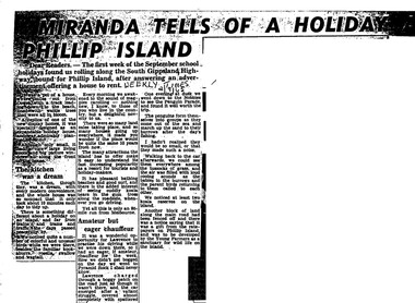
Work on paper - Photocopy of newspaper cutting, Herald and Weekly times, "MIRANDA TELLS OF A HOLIDAY ON/ PHILLIP ISLAND"
Miranda was a very popular journalist of this era, whose homely style appealed to many readers, especially women, her main audience in her writing. Here she talks about renting a new demonstration holiday home (probably a Coldon Home), which, although small, had a 'dream kitchen'. She describes the birds and walk through the wattle to the beach, but also the many blocks for sale and wonders what the island will be like in 10 years time from their visit. Her son drove them to Pyramid Rock where they almost got bogged on the road. They visit the usual spots, which she describes with a combination of curiosity and enjoyment. She also mentions another block fenced off on the main road which was a gift from the ratepayers of Phillip Island, and which the Young Farmers were to plant out for koala trees.This article is significant because thousands of Weekly Times newspaper readers read Miranda’s letter article without fail each edition. She describes renting a house for a holiday, which indicates the move away from family holidays in guest houses. She also describes some of the rough roads in parts of the island at the time. She concentrates on the island’s natural attractions rather than man- made tourist attractions, which is also significant in letting us see why people would visit Phillip Island in that era. Miranda also predicts the explosion of the holiday home owner market which took place soon after, and continues today though in a more controlled way.Photocopy of newspaper article cut out from full page. Cutting has three columns of text, no images. Black text on white paper. Dark areas due to poor photocopyingWEEKLY TIMES / 2/9/65phillip island, miranda, weekly times newspaper, holiday home, phillip island flora and fauna, pyramid rock, phillip island pengiun parade, young farmers, phillip island beaches, cuddly koala bears, phillip island housing estate land sales -
 Phillip Island Conservation Society Inc.
Work on paper - Photocopy of newspaper cutting, "PHILLIP ISLAND/A place to fall in love"
This article was written by an English visitor named Elsa Christian who was touring Australia and New Zealand with her husband Frank in their own small van. The article was published in the Australian Women’s Weekly, magazine, March 1966. Elsa writes she wanted to visit four Australian locations before she died: Ayers Rock (actually Uluru), the Snowy River project, dolphins at Coolangatta and the Penguin Parade at Phillip Island. These destinations were all very popular in the 1960s for both Australian residents and overseas visitors. Because the roads were becoming better too many locations, self guided tours in small vans for cars towing bond would caravans were becoming more popular means of seeing AustraliaThe article is significant in many ways. 1. Indicates the places English visitors commonly wish to see in Australia. 2. Describes the growing trend to self- drive van/camping holidays. 3. Gives the route taken from Melbourne to Phillip Island during the 1960s. 4. Describes the appearance of the roadsides and locations visited. 5. It is written in a descriptive and lyrical style designed to appeal to Women’s Weekly magazine readers, who were probably wondering how they could visit Phillip Island with their husbands or families themselves, and what there was to see there. 6. Gives the visitors’ view of how the Penguin Parade operated at the time. 7. Includes a description of potter and artist Eric Juckert’s renowned garden at Grossard Point, Ventnor. 8. Indicates how introduced plants such as Hawthorn pushes and Kate weed were common in the area. 9. Describes Phillip Island as “a place to fall in love” because of its natural beauty, fauna and coastal seascapes. 10. As a visitor Elsa describes the housing estates as a blot on the landscape, but also sees the value as a way of their owners escaping from the hustle and bustle of Melbourne. 11. Gives the visitors’ interpretation of the behaviour of wildlife the RC in the wild, as well as Elsa’s knowledge about some of the species she encounters.Photocopy of full page article with 5 columns of text, a map and 2 photographs. Black ink on white paper. Photographs blackened in photocopying processphillip island, cape woolamai, penguin parade, seal rocks, nobbies, township of rhyll phillip island, princes highway, dandenong, pakenham, kooweerup, carinya creek, officer, san remo, gippsland highway, holiday homes, fort dumaresq, kitty miller's beach, wreck of the speke, hereford cattle, fleetwood manor, koalas, ventnor, eric juckert, little penguin behaviour -
 Wodonga & District Historical Society Inc
Memorabilia - Souvenir Ashtray Hume Weir Wodonga
Metal, china and glass ashtrays and other small pieces carrying scenic views of holiday destinations were a popular kind of souvenir during much of the 20th century. The pictures on the souvenirs ranged across natural beauty spots (beaches, waterfalls, rivers), civic buildings and monuments (town halls, war memorials), and indicators of local progress (commercial centres and occasionally even industrial sites).This ashtray is representative of a range of souvenirs used in the 20th century to depict Wodonga, Victoria and also on a State and National level throughout Australia.A metal circular ashtray including a coloured enamel image of the Hume Weir in the cenre."Above the central image "HUME WEIR" Beneath the central image "WODONGA"souvenir, hume weir, wodonga, ashtray -
 City of Kingston
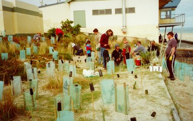
Photograph - Colour, 30 July 2000
This photograph depicts workers/volunteers participating in tree planting on the foreshore as part of National Tree Day. It is uncertain which beach is it.Colour photograph of a gropu of people on a beach foreshore with a building (presumably surf life saving club) in the background. In front of the group are a many freshly planted trees surrounded by ground steaks and green plastic sheeting.Handwritten in black ink: National Tree Day / 30 July 2000 / Bon Beach? / Edithvale?ocean, trees, environment, volunteers -
 City of Kingston
Photograph - Colour, 31 January 1993
Patterson Lakes is a suburb in the City of Kingston that is built one kilometre upstream of the mouth of the Patterson River. The area is bordered by the Patterson River and Eel Race Drain which enters the Kananook Creek. The suburb consists predominantly of newer housing developments and the tidal canal system of the development joins Port Phillip Bay. Patterson Lakes and the Kananook Creek were previously part of the extensive Carrum Carrum Swamp. The area was once a source of fish and eels for the Mayone-Bulluk clan of the Bunurong people. Over time the area was drained and in 1973 investigations commenced into the development of a unique residential area that would be built adjacent to canals and waterways. It was originally proposed to be known as "Gladesville". The development would give the suburb's homeowners access to Port Phillip Bay "from their back door". Circa 1974, the area was rezoned from rural to residential and named Patterson Lakes. Development has been continuous since the 1970s with construction of residential housing, schools, shopping centres, marinas, a hotel and library.Laminated colour aerial photograph of the Carrum and Patterson Lakes region within City of Kingston. This 1993 image includes Patterson River Secondary College, Roy Dore Reserve, Kananook Creek and Nepean Highway. The railway line can be seen as it veers inland from Eel Race Road, Seaford. The section of Ocean Reef Drive and Palm Beach Drive in Patterson Lakes appears to be a recent development with many spare blocks and new houses under construction.Black typed lettering on white adhesive label: 31.1.93 Black typed lettering on white adhesive label: 27E/7140 31/1/93 12.55 pm Black typed lettering on white label: 7140 Yellow round adhesive label located on left sidepatterson lakes, seaford, kananook creek, carrum carrum swamp, canals and waterways -
City of Kingston
Photograph - Colour, c. 1993
Patterson Lakes is a suburb in the City of Kingston that is built one kilometre upstream of the mouth of the Patterson River. The area is bordered by the Patterson River and Eel Race Drain which enters the Kananook Creek. The suburb consists predominantly of newer housing developments and the tidal canal system of the development joins Port Phillip Bay.Patterson Lakes and the Kananook Creek were previously part of the extensive Carrum Carrum Swamp. The area was once a source of fish and eels for the Mayone-Bulluk clan of the Bunurong people. Over time the area was drained and in 1973 investigations commenced into the development of a unique residential area that would be built adjacent to canals and waterways. It was originally proposed to be known as "Gladesville". The development would give the suburb's homeowners access to Port Phillip Bay "from their back door". Circa 1974, the area was rezoned from rural to residential and named Patterson Lakes. Development has been continuous since the 1970s with construction of residential housing, schools, shopping centres, marinas, a hotel and library.Laminated colour aerial photograph of the Carrum and Patterson Lakes region within City of Kingston. This 1993 image includes Patterson River Secondary College, Roy Dore Reserve, Kananook Creek and Nepean Highway. The railway line can be seen as it veers inland from Eel Race Road, Seaford. The section of Palm Beach Drive, Curlew Point Drive, Snapper Point Drive, Clipper Island and Myola Street in Patterson Lakes appears to be a recent development with many spare blocks and new houses under construction.patterson lakes, seaford, kananook creek, carrum carrum swamp, canals and waterways -
City of Kingston
Photograph - Colour, 6 March 1993
Edithvale is a suburb in the City of Kingston. It is located between Aspendale and Chelsea on the Port Phillip Bay and built within remnant areas of the Carrum Carrum swamp. The foreshore precinct comprises a wide sandy beach, with low sand dunes and numerous historic boat sheds. The suburb consists of older style dwellings and former holiday houses, combined with mid-century housing and newer homes. The large blocks are increasingly subdivided and the existing dwellings demolished to accommodate units and townhouses, thus changing the landscape of the area and reducing the tree canopy.The beachside suburb of Edithvale was previously part of the extensive Carrum Carrum Swamp. The area was once a source of fish and eels for the Mayone-Bulluk clan of the Bunurong people. Over time the area was drained and predominantly devoted to dairy farming and holiday houses. The farms were gradually sold and subdivided with a large number of homes built after World War II and in the 1960s. Edithvale is mainly residential with a shopping strip along Nepean Highway but little significant industry was ever established in the area apart from a plaster works and confectionary factory, both now closed.Laminated aerial colour photograph of Edithvale as viewed from Alexandra Avenue in the north to Ella Grove Chelsea/Edithvale in the south. regents Park Aspendale can be seen in the top left. The area is built-up with residential housing and facilities including Edithvale Primary School, numerous churches and the Edithvale Railway station. Large sections depict the remnant Carrum Carrum swamp. Edithvale Common and the former "Duck Inn" (Melbourne Water/Friends of Edithvale Seaford Wetlands) can be seen. Edithvale Recreational reserve, the valodrome and Edithvale Public Golf Course are prominent. The image shows vacant land in the area now known as Aspendale Gardens and the newer residential section of Chelsea Heights is not developed. A bike path has been established to cover the secondary drain. The Golf Links Court residential development located off Hughes Avenue is a large vacant block.Black type on white adhesive label: 6-3-93 Black type on white adhesive label: 25/9211, 6/3/93, 11.20 am Black type on white adhesive label: 9211 Yellow circular adhesive sticker Black pencil: 9211 6-3-93 arrow pointing Nedthvale, carrum carrum swamp, aspendale, chelsea -
 City of Kingston
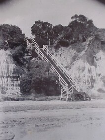
Photograph - Black and white, Percy Fairlam, c. 1910
High cliffs required access to the beachfront to be made via a steep wooden staircase.Black and white image of the steep wooden staircase at Mentone Beach, leading down to the foreshore from the clifftops above. At the base of the staircase is a bicycle leaning against a foundation post.mentone, beach, staircase, access -
 City of Kingston
Photograph - Digital image, Colour, City of Kingston (Graham Whitehead)
Colour image of Mentone foreshore looking towards Mordialloc. The natural environment of Kingston significantly impacted its development. The bay was a source of food and income, as well as a holiday destination. Colour image of Mentone beach looking towards Mordialloc, with Mentone life saving club in distance.mentone, beach, environment -
 Melbourne Legacy
Photograph, Holmbush excursion to the beach, 194X
Photo of an excursion of Holmbush children to the beach possibly in the 1940s. It is probably a Legatee that is with the boys. The names are not known but most of the boys appear in other photos from the photo album. From a photo album which contains photos of Holmbush and some of the excursions and events that happened there, appears to have been put together in the 1940s. Including trips to the zoo and picnics. Holmbush at 1267 Burke road, was one of the properties that Legacy used for Junior Legatees. It was purchased 1942. In 1957 Holmbush was renamed Blamey House until it was sold in 1977.A compilation of photos of the junior legatees in the Legacy residences.Black and white photo of four boys and a legatee at the beach pasted to the page of an album.residences, holmbush, beach -
 Melbourne Tram Museum
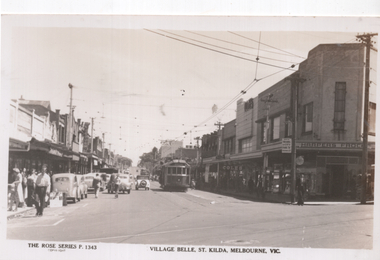
Postcard, Rose Stereograph Co, "Village Belle, St Kilda, Melbourne Vic", early 1950s
Rose Series postcard No. P 1343, titled "Village Belle, St Kilda, Melbourne Vic" showing W2 568 (Moreland Route 15) at the St Kilda Beach terminus in Ackland St. Another W2 is further behind. A uniformed tramway employee is walking across the road, underneath a MMTB sign advising of Trams to the City and a Fare of 5d and child fares of 2d. In the background is the Coles store and Harpers Frocks. In the foreground are tram tracks for the Victorian Railways St. Kilda to Brighton Beach line in Buckly Street.Yields information about Ackland St, St Kilda early 1950s.Postcard - printed real photograph with Rose Stereograph Co. name on the rear.trams, tramways, village belle, ackland st, route 15, st kilda, w2 class, tram 568