Showing 33233 items matching "buildings/streetscapes"
-
 Eltham District Historical Society Inc
Photograph, Alistair and Margot Knox House
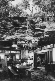
Image 18 Alistair and Margot Knox House Designed and built by the owners The Alistair Knox Collection The Alistair Knox Collection is a series of mounted enlarged photos of mud brick houses and related subjects. The collection is understood to have been put together by Alistair Knox although it is the work of several unacknowledged photographers. For some years it was held by the Building Department of the former Eltham Shire Council and was then passed to our Society for safekeeping. Some of the photos have been used in Knox's books and from time to time some of them have been part of various historical displays. As far as we know there has not been a public display of the whole collection which numbers about forty photographs. The collection has been copied on to slides for the purpose of this meeting and to be retained as part of the Society's pictorial collection. Alistair Knox 1912 - 1986 is acknowledged as the founder of Eltham's mud brick building movement. Many of the buildings shown in the collection are of his design and he was also involved with the construction of several of them. Others are the work of his contemporaries and associates such as Peter Glass, Gordon Ford, and John Harcourt. (EDHS Newsletter No. 145 July 2002)Handwritten notes in pencil re details of building, year of construction, owner, designer, builder, etcalistair and margot knox house, alistair knox, alistair knox design, houses, margot knox, mud brick construction, alistair knox collection -
 Eltham District Historical Society Inc
Photograph, Bateman House (1961)
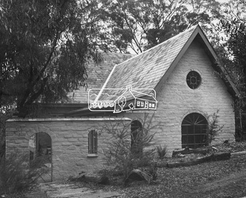
Image 17 Bateman House 1961 Designed and built by John and Pattie Bateman and family The Alistair Knox Collection The Alistair Knox Collection is a series of mounted enlarged photos of mud brick houses and related subjects. The collection is understood to have been put together by Alistair Knox although it is the work of several unacknowledged photographers. For some years it was held by the Building Department of the former Eltham Shire Council and was then passed to our Society for safekeeping. Some of the photos have been used in Knox's books and from time to time some of them have been part of various historical displays. As far as we know there has not been a public display of the whole collection which numbers about forty photographs. The collection has been copied on to slides for the purpose of this meeting and to be retained as part of the Society's pictorial collection. Alistair Knox 1912 - 1986 is acknowledged as the founder of Eltham's mud brick building movement. Many of the buildings shown in the collection are of his design and he was also involved with the construction of several of them. Others are the work of his contemporaries and associates such as Peter Glass, Gordon Ford, and John Harcourt. (EDHS Newsletter No. 145 July 2002)Handwritten notes in pencil re details of building, year of construction, owner, designer, builder, etcbateman house, houses, john bateman, mud brick construction, pattie bateman, alistair knox collection -
 Eltham District Historical Society Inc
Photograph, Tools of the trade
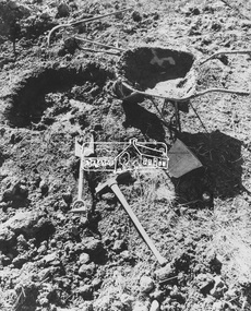
Image 28 Tools of the trade The Alistair Knox Collection The Alistair Knox Collection is a series of mounted enlarged photos of mud brick houses and related subjects. The collection is understood to have been put together by Alistair Knox although it is the work of several unacknowledged photographers. For some years it was held by the Building Department of the former Eltham Shire Council and was then passed to our Society for safekeeping. Some of the photos have been used in Knox's books and from time to time some of them have been part of various historical displays. As far as we know there has not been a public display of the whole collection which numbers about forty photographs. The collection has been copied on to slides for the purpose of this meeting and to be retained as part of the Society's pictorial collection. Alistair Knox 1912 - 1986 is acknowledged as the founder of Eltham's mud brick building movement. Many of the buildings shown in the collection are of his design and he was also involved with the construction of several of them. Others are the work of his contemporaries and associates such as Peter Glass, Gordon Ford, and John Harcourt. (EDHS Newsletter No. 145 July 2002)Handwritten notes in pencil re details of building, year of construction, owner, designer, builder, etcmud brick construction, tools, alistair knox collection -
 Melton City Libraries
Photograph, Church of England, Unknown
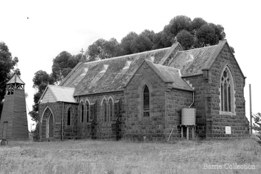
Built in 1869 and opened in 1872 by Bishop Perry In 1988, it was dismantled and rebuilt in Wadonga. Efforts were made to save the building. The foundations needed significant work. Many of its adherents were deeply distressed by its loss. It was strongly linked with the Staughton family and therefore of important significance to MeltonChurch of England bluestone building.churches, local architecture -
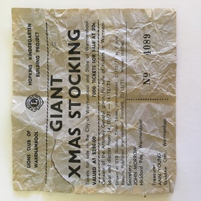 Warrnambool and District Historical Society Inc.
Docket, Giant Xmas Stocking, 1971
This portion of a raffle ticket is from a raffle conducted by the Warrnambool Lions Club in 1971. The proceeds went towards the building fund of a Warrnambool kindergarten which is at 31 Gladstone Street, Warrnambool and is today known as the Lions Hopkins Kindergarten. The Warrnambool Lions Club was formed in 1959 and was chartered in May 1960. At the time the charter presentation was the largest charter night gathering ever held in Australia (210 people present). The Warrnambool Lions Club continues to operate as a service club. This raffle ticket is of interest as an early example of the fundraising efforts of the Warrnambool Lions ClubThis is a piece of paper, now much yellowed. It is one section of a raffle ticket and has black printing and the Lions Club logo. It is partly torn. Lions Club of Warrnambool, Hopkins Kindergarten Building Project Giant Xmas Stocking. warrnambool lions club, lions hopkins kindergarten warrnambool -
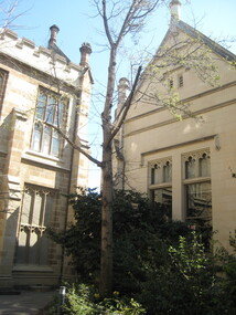
 Ballarat Heritage Services
Photograph - Colour, Clare Gervasoni, University of Melbourne Old Commerce Building, 2010, 29/09/2010
Melbourne University Old Physics Building (1889) was designed by Reed, Henderson and Smart. It later house the Univesity's Centre for Indigenous Education and a conference centre (2010).Colour photograph of The Old Commerce Building, later part of Architecture. An 1856 Reed designed Bank of New South Wales faced was incorporated into the original 1940 building. university of melbourne, old law building, eight hour day, stonemasons, tasmanian freestone, cloisters, edward stevens, wilson trust, wildred brookes -
 Glenelg Shire Council Cultural Collection
Souvenir - First Day Cover, c. 1990
Envelope, First Day Cover commemorating Casterton's First Postmaster. White envelope, photo of Casterton streetscape. 41c stamp, cancel stamp, dated 12 July 1990.casterton post -
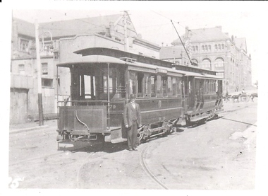 Bendigo Historical Society Inc.
Photograph - BASIL MILLER COLLECTION: TRAM 79
Black and white photo of tram no 79 on streetscape, horse drawn gigs in background, tramways employee standing towards front of tram in uniform. '(7)' written on back of photo.person, individual, basil miller -
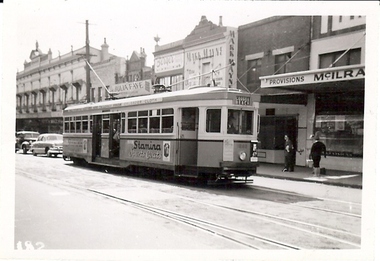 Bendigo Historical Society Inc.
Photograph - BASIL MILLER COLLECTION: TRAM TO COOGEE BEACH
Black and white photo of tram on streetscape, destination showing as Coogee Beach. 'LB Manny Collection Photo No 162' stamped on back, '(31)' written in ink on back of photo.person, individual, basil miller -
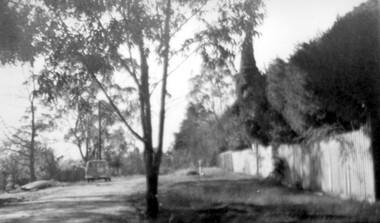 Surrey Hills Historical Society Collection
Photograph, Beatty Street, Mont Albert
The Lodewyckx family made their home at 3 Beatty Street, Mont Albert coming to the area after staying for six months at 'Medlow', the home of Dr Bull and his family while the latter were overseas. Augustin was in charge of the German Department at Melbourne University starting during the rather difficult days of the 1920s. A black and white photograph of a streetscape. There is a fence in front of a hedge along the right hand side of the photograph. There is a van parked on the left hand side of the photograph. There are many trees in the background.beatty street, mont albert, 1940-1949, lodewyckx family -
Clunes Museum
Mixed media - NATIONAL TRUST AWARD, 2006
SUBMISSION: CLUNES TOURIST & DEVELOPMENT ASSOCIATION PRODUCTION: CTDA MEMBERS TEXT: DR TESS BRADY PHOTOGRAPHY: NEIL NEWITTFOLDER CONTAINING C.D. AND PRINTED AWARD FROM THE NATIONAL TRUST PROVINCIAL VICTORIA HISTORIC TOWNS AWARDS. CATEGORY 1: THE TOWN WITH THE MOST INTACT HERITAGE STREETSCAPE CHARACTERlocal history, documents, awards, town award, ctda -
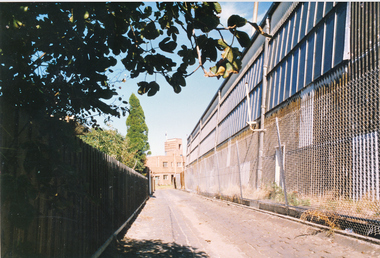 Port Melbourne Historical & Preservation Society
Photograph - Laneway off Swallow Street, rear of Missions to Seamen, Port Melbourne, Alison Kelly, 1990
Photographed by Alison Kelly while she was joint caretaker of the building during the Mission Arts Centre days 1987 to 1991From album of photos mostly by Alison Kelly: view down the lane behind Swallow Street toward the rear of the Port Melbourne Missions to Seamen building (Telecom building on right)missions to seamen, built environment, alison kelly -
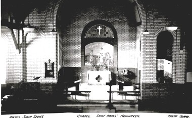 Phillip Island and District Historical Society Inc.
Photograph, St Paul's Training School Chapel and School, 1947
Photos from various sources added to an album on the Boy's homeHistorical3 black and white photographs of buildings and interior of chapel86-15 has Photo Shop Series Chapel st Paul's Newhaven Phillip Island. 86-16 has in handwriting St Paul's Church of England Boy's Home Newhaven Cowes 6/3/47.on back is written -' We were taken over this.Part in photo is chapel, everything in chapel was made by boys. building at right dormatories."newhaven boy's home phillip island, photographs -
 Buninyong & District Historical Society
Photograph - Photo of Original Photograph, King Family home, Durham Lead
historic, social, buildingsB/W photo King Family home, Durham Lead, two sisngle story buildings.durham lead, king family -
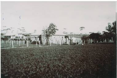
 Lakes Entrance Historical Society
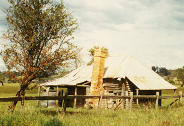
Photograph - Early Building along the Great Alpine Road, M Fish, 1980 c
... Buildings ...Building collapsed in 2015Colour photograph of very old building on the Great Alpine Road between Bairnsdale and Bruthen Victoriaagriculture, buildings -
 Vision Australia
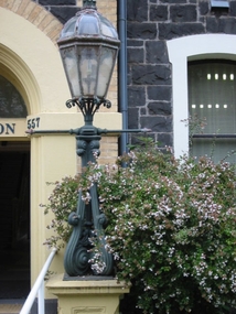
Photograph - Image, Lamp post outside entry to St Kilda Road
Image taken of a lamp outside the reception door of the RVIB St Kilda Road building.1 col. image of lamp outside St Kilda Road buildingroyal victorian institute for the blind, fundraising -
 Federation University Historical Collection
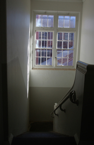
Photograph - Colour, Ballarat School of Mines Old Chemistry Building Stairway, 2013, 23/09/2013 and 10/2015
This building is now on the Federation University Australia Mount Helen campusSix photographs featuring stairways in the Ballarat School of Ballarat Old Chemistry Building. ballarat school of mines, old chemistry building, stairway, stairs -
 Clunes Museum
Photograph, CIRCA 1940
BUILDING OF BRIDGE OVER MOUNT CREEK ON ROAD TO MOUNT BECKWORTH.PHOTOGRAPH OF TOM HARVEY AND FRANK CARROLAN, BUILDING BRIDGE OVER MOUNT CREEK.local history, photography, photographs, bridges -
 Sunbury Family History and Heritage Society Inc.
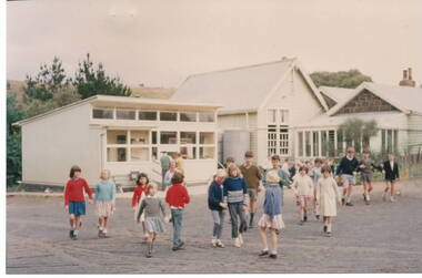
Photograph, Bulla Primary School, 1964
The school in the photograph is Bulla State School No. 46 and was originally known as the Government -funded Bulla Common School, built 1870 - 1871. With the passing of the Education Act in Victoria in 1873 it became known as Bulla State School No. 46. The original building comprised of a rectangular shaped bluestone building with a 3 roomed residence attached. As school enrolments began to increase in the district, a weatherboard classroom was added in 1881 and later extended in 1927 adjacent to the original building with a covered walkway between the two buildings. The modern portable classroom was added in the 1960s. Bulla Primary School closed in 1996 after much local controversy. The property is now privately owned. The photograph was taken in 1964.The bluestone section of the school with residence is one of very few remaining in the state and is of local heritage classification in the City of Hume.A non-digital coloured photograph of children in a school playground with the buildings visible in the background.bulla state school no. 46, school lane, bulla, education act 1873, common schools -
Federation University Historical Collection
Photograph, Plaque for the Opening of the Ballarat School of Mines Amenities Building, 1981, 1981
Plaque for the Opening of the Ballarat School of Mines Amenities Building by Governor of Victoria Sir Henry Winneke.School of Mines & Industries Ballarat Amenitues Building was officially opened by His Excellency The Hon Sir Henry Winneke K.C.M.G., K.C.V.O., O.B.E., K.St. J., O.C. Governor of Victoria on 7th October 1981 G.H. Beanland K.J. Flecknoe Principal Presidentballarat school of mines, amenities building, building, henry winneke, graham beanland, ken flecknoe -
 Federation University Historical Collection
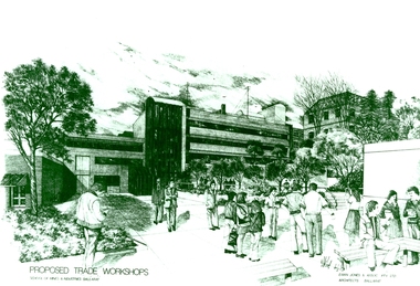
Photograph - Photograph - Black and White, Proposed Ballarat School of Mines Trade Workshops, c1984
A design for a Trade and Art Workshop at the Ballarat School of Mines was prepared by Ewan Jones and Associates on the Albert Street boundary around 1984. The M.B. John Building (Building K), a three storey, face red brick, restrained Late Twentieth Century International styled building with an elongated, cuboid form (defined by the parapeted facades) that is offset by projecting exposed concrete framed, round‐arched entrance and stair wells on the east (Albert Street) elevation (the centrally located entrance breaking the brick façade with glazing). The facades are also characterised by banks of aluminium framed, horizontal ribbon windows, which wrap around the building corners. Metal shades project beyond the windows, while post‐supported bullnosed verandahs and hoods and projecting concrete stairs are other features. On the west elevation, the cuboid façade is punctuated by projecting curved concrete and glazed, elongated bays at first floor level. (David Rowe/Wendy Jacobs) The M.B. John Trade–Art building of SMB was officially opened by the Hon. John Cain, Premier of Victoria, in the presence of Morgan B. John. Programs include 3 Dimensional Art, Painting & Decorating, and Engineering Trades. (SMB Institutional Plan 1989)Black and white photograph of a sketch for the proposed Trade Workshops at the Ballarat School of Mines, from the Albert Street vantage point. This building is known as the M.B. John Building on the SMB Campus.ballarat school of mines, trade workshops, flecknoe, m.b. john, ewan jones and associates pty ltd, albert street, morgan b. john, ewan jones and associates -
 Federation University Historical Collection
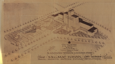
Plan - Architectural Drawing, Ballarat School of Mines: The Proposed Six Storied Main Building, 5 December 1947
Drawing of the School of Mines site showing the proposed six storied Main Building to replace the existing historical gaol building. This was never built. This was sent to Jack Barker in 1970 by Jim Docherty. He was a member of the Board of Technical School Inspectors, Education DepartmentDrawing of the propose six storied main building for the School of Mines site, Ballarat.ballarat school of mines, historic buildings, percy everett, architect, architectural drawing, jack barker, jim docherty, education department -
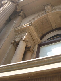
 Ballarat Heritage Services
Photograph - Colour, Clare Gervasoni, University of Melbourne Old Physics Building, 2010, 29/09/2010
Melbourne University Old Physics Building (1889) was designed by Reed, Henderson and Smart. It later house the Univesity's Centre for Indigenous Education and a conference centre (2010).Colour photograph of the Melbourne University Old Physics Building.university of melbourne, old physics building -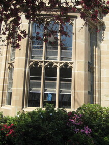
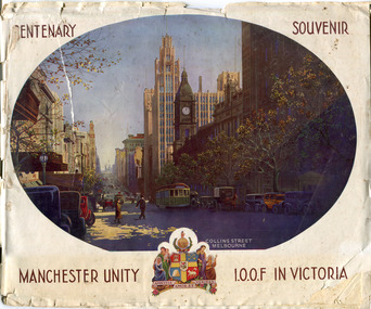 City of Moorabbin Historical Society (Operating the Box Cottage Museum)
Booklet - Centenary Souvenir - Manchester Unity I.O.O.F in Victoria, IOOF Melbourne, 1934
A booklet issued by The Grand Master and Board of Directors M.U.I.O.O.F. in Victoria and compiled by W .H. Best, Grand Secretary printed in the year the City Of Melbourne began the celebration of its Centenary (1934). The booklet is about the history of Manchester Unity I.O.O.F. and the building of their Gothic building, known as the Manchester Unity Building on the corner of Collins and Swanston Streets, Melbourne. The booklet also contains many advertisements from firms who supported the compiling and publishing of the document.Many of the families living in the City of Moorabbin were members of Manchester Unity I.O.O.F. Victoria.A booklet with 40 pages printed in black and white, contents include story of the building of the Manchester Unity Building on the corner of Collins Street and Swanston Street. Advertisements of various businesses in Melbourne. Coloured Cover with a view of Collins Street.CENTENARY SOUVENIR/ PHOTO of Collins St Melbourne, / MANCHESTER UNITY / Crest of Arms/ I.O.O.F IN VICTORIAmanchester unity i.o.o.f. victoria, manchester unity building, collins street, swanston street -
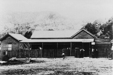 Halls Gap & Grampians Historical Society
Photograph - B/W, C 1920s
... BUILDINGS ...The photo is of Halls Gap's first General Store, opened in 1921. The store comprised a substantial shop and residence close to today's (2009) Public Hall. The people in front of the building are the operators of the store, J. Hemley (third from right), R. Mair (fourth from right) and Mrs J. Hemley with baby (on left). The identity of the other people unknown.Photograph of a wooden (? log) building with a wooden picket fence at the front. Three people are standing in front of the building at the gate, there are a few people on the verandah of the building and a child riding past the front on a bicycle.buildings, shops -
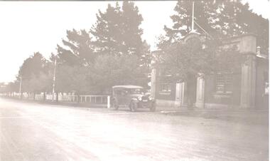 Hume City Civic Collection
Photograph
This building built as the Mechanics Institute in 1885 and taken over by the Shire of Bulla in 1922 to be remodelled as the Soldiers Memorial Hall.A black and white photo of a brick building in a tree-lined street with a car parked out the front with a man at the steering wheel. There are large pine trees in the background. The building is the Soldiers Memorial Hall.memorial hall, shire of bulla, soldiers memorial hall, exservice organisations, george evans collection -
 Eltham District Historical Society Inc
Photograph, Clifton Pugh Studio and House (1950)
Image 11A Clifton Pugh Studio and House commenced 1950 Designed and built by Clifton Pugh and others A view from the courtyard The Alistair Knox Collection The Alistair Knox Collection is a series of mounted enlarged photos of mud brick houses and related subjects. The collection is understood to have been put together by Alistair Knox although it is the work of several unacknowledged photographers. For some years it was held by the Building Department of the former Eltham Shire Council and was then passed to our Society for safekeeping. Some of the photos have been used in Knox's books and from time to time some of them have been part of various historical displays. As far as we know there has not been a public display of the whole collection which numbers about forty photographs. The collection has been copied on to slides for the purpose of this meeting and to be retained as part of the Society's pictorial collection. Alistair Knox 1912 - 1986 is acknowledged as the founder of Eltham's mud brick building movement. Many of the buildings shown in the collection are of his design and he was also involved with the construction of several of them. Others are the work of his contemporaries and associates such as Peter Glass, Gordon Ford, and John Harcourt. (EDHS Newsletter No. 145 July 2002)Handwritten notes in pencil re details of building, year of construction, owner, designer, builder, etcclifton pugh, clifton pugh studio and house, dunmoochin, houses, mud brick construction, alistair knox collection -
 Eltham District Historical Society Inc
Photograph, Bob and Ada Zull House (1970)
Images 9B Bob and Ada Zull house built 1970 Designed and built by Alistair Knox Floor laid by Ada Zull The Alistair Knox Collection The Alistair Knox Collection is a series of mounted enlarged photos of mud brick houses and related subjects. The collection is understood to have been put together by Alistair Knox although it is the work of several unacknowledged photographers. For some years it was held by the Building Department of the former Eltham Shire Council and was then passed to our Society for safekeeping. Some of the photos have been used in Knox's books and from time to time some of them have been part of various historical displays. As far as we know there has not been a public display of the whole collection which numbers about forty photographs. The collection has been copied on to slides for the purpose of this meeting and to be retained as part of the Society's pictorial collection. Alistair Knox 1912 - 1986 is acknowledged as the founder of Eltham's mud brick building movement. Many of the buildings shown in the collection are of his design and he was also involved with the construction of several of them. Others are the work of his contemporaries and associates such as Peter Glass, Gordon Ford, and John Harcourt. (EDHS Newsletter No. 145 July 2002)Handwritten notes in pencil re details of building, year of construction, owner, designer, builder, etcada zull, alistair knox, alistair knox design, bob and ada zull house, bob zull, houses, mud brick construction, alistair knox collection