Showing 1045 items matching "main office"
-
 Ballarat Heritage Services
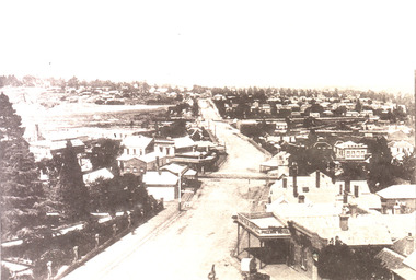
Image, View of Ballarat East from from the Fire Brigade Tower, c1895, c1895
... Office goldfields ballarat east main road ballarat east ballarat ...Black and white image of the view of Ballarat East along Main Road. The photograph was taken from the Ballarat Fire Brigade Tower.ballarat east, main road ballarat east, ballarat fire brigade, phoenix hotel -
 Ballarat Heritage Services
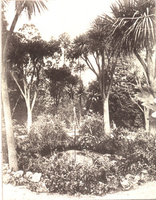
Image, Ballarat East Gardens, c1895, c1895
... Office goldfields ballarat east main road ballarat east ballarat ...Black and white image of the a fountain in the Ballarat East Gardens. ballarat east, main road ballarat east, ballarat east gardens -
 Ballarat Heritage Services
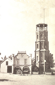
Photograph - Image, Ballarat Fire Brigade, c1895, c1895
... Office goldfields ballarat east main road ballarat east ballarat ...Black and white image of the Ballarat Fire Brigade in Main Road Ballarat East.ballarat east, main road ballarat east, ballarat east gardens, fire brigade -
 Ballarat Heritage Services
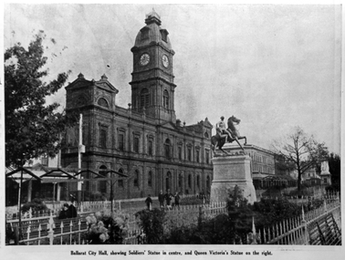
Photograph - Image, Ballarat Town Hall and Sturt Street Gardens, 1922, 1922
The Sturt Street Gardens run down the centre of Ballarat's main street. It boast many statues. In front of the depicted Ballarat Town Hall is the Boer War Memorial which commemorates soldiers who have taken part in the South African War. The scuplture is by James White, and it was proposed by Cr J.J. Brokenshire, and was approved at the Council meeting on 31 May 1900. The foundation stone was laid on May 1901 but was relocated to the present site and re-laid by the then Mayor Brokenshire. The stature was unvelied on 01 November 1906 by the Governor General Baron Northcote.Copy of a photograph showing Ballarat Town Hall, Sturt Street gardens, and the Boer War Monument. ballarat, ballarat town hall, boer war monument, sturt street gardens, boer war memorial, statues -
 Ballarat Heritage Services
Photograph - Colour, Clare Gervasoni, Villa Parma, Hepburn Springs, 2005, 12/10/2005
Parma House was bult by Italian born Fabrizio Crippa. It was restored from a burnt wreck to Villa Parma by Richard Rigby and Franchek. Walls were scraped back to the original, and burnt umber detailing added. The garden was created by Richard Rigby and Kevin Flintoff.View from the second storey window of Parma House, Main Road, Hepburn Springs.villa parma, fabrizio crippa, parma house, richard rigby, kevin flintoff, garden, hepburn springs -
 Ballarat Heritage Services
Photograph - Photograph - Colour, Clare Gervasoni, Former Yandoit Hills School 2052 after being moved to Hepburn Springs, c2005, c2005
This building was moved from Yandoit Creek to the corner of Main Road and Seventh Street, Hepburn Springs. Colour photograph of on old schoolhouse that was moved from Yandoit Hills to the corner of Main Road and Seventh Street, Hepburn Springs. The building was used for religious services before being turned into a private residence. yandoit hills state school no 2052, education, hepburn springs, yandoit hills, yandoit creek -
 Ballarat Heritage Services
Photograph - Colour, Clare Gervasoni, Interior of Villa Parma, Hepburn Springs, 2005, 12/10/2005
Parma House was bult by Italian born Fabrizio Crippa. It was restored from a burnt wreck to Villa Parma by Richard Rigby and Franchek. Walls were scraped back to the original, and burnt umber detailing added. The garden was created by Richard Rigby and Kevin Flintoff.Interior view of the interior of Parma House, Main Road, Hepburn Springs.villa parma, fabrizio crippa, parma house, richard rigby, kevin flintoff, garden, hepburn springs, foyer -
 Ballarat Heritage Services
Photograph - Colour, Clare Gervasoni, Interior Staircase at Villa Parma, Hepburn Springs, 2005, 12/10/2005
Parma House was bult by Italian born Fabrizio Crippa. It was restored from a burnt wreck to Villa Parma by Richard Rigby and Franchek. Walls were scraped back to the original, and burnt umber detailing added. The garden was created by Richard Rigby and Kevin Flintoff.Interior view of the staircase at Parma House, Main Road, Hepburn Springs.villa parma, fabrizio crippa, parma house, richard rigby, kevin flintoff, garden, hepburn springs, foyer -
 Ballarat Heritage Services
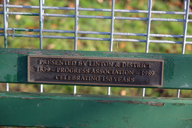
Photograph - Colour, Linton, Victoria, 2013, 22/05/2013
Colour photographs taken in the main street of Linton, Victoria.linton -
 Ballarat Heritage Services
Photograph - Colour, Clare Gervasoni, Linton, Victoria, 2013, 22/05/2013
Colour photographs taken in the main street of Linton, Victoria.linton -
 Mt Dandenong & District Historical Society Inc.
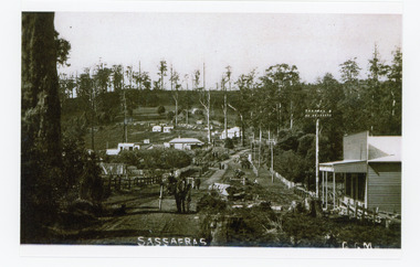
Photograph, Sassafras, c1915
The south end of Sassafras Main Street outside the Big Store (Sherrards), built in 1912 that sold a bit of everything. The early settler Arthur Goode, who arrived in 1893, originally owned the land. Arthur Goode ran the Post Office in a bark hut until he moved away in 1911. From 1912 the Post Office operated from a room in Hinkley Guest House from 1912 until 1937.Black and white copy of a GGM photograph of Sassafras. A man driving a horse and cart is coming up the road towards the camera while several couples can be seen strolling down the road. The early buildings of Sassafras are clearly visible.sherrards, sassafras, arthur goode, goode, hinkley, post office -
 Mt Dandenong & District Historical Society Inc.
Photograph, View of Kalorama Gap 1905
Kalorama Gap viewed from the South West in 1908. Ellis Jeeves' 'Mountjoy' is in the centre with the stables to the left. The raspberry patch belongs to Harry Walker and the building centre right to Edward Joseph Price. John Lundy-Clarke grew up in the Kalorama/Mt Dandenong area and later in life (1972-74) began to write a comprehensive history of the area working from an original settlement map in an effort to cover all areas.Black and white photograph showing an extensive raspberry crop in the foreground with a house and outbuilding in the centre and another dwelling centre right. Handwritten description on reverse by John Lundy-Clarke. 1908 view of Kalorama Gap taken from corner of Village Settlement LOTS 2 and 3 on Ridge (then Main Road) which crosses centre of picture with Walker’s driveway dropping left. Walker’s raspberry patch in foreground. “Mountjoy” in centre of picture with coaching stables on left. Price’s house and shop on right showing large cross room used by the Village Settlers for dancing. Mrs Hand’s “Beulah Tearooms” later Mt Dandenong North Post Office is above Price’s roof.kalorama gap, kalorama, harry walker, walker, edward joseph price, raspberry, mountjoy -
 Mt Dandenong & District Historical Society Inc.
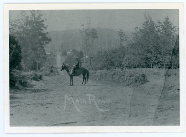
Photograph, Looking Down Falls Road
... Joseph Price Lily Badenhop post office Falls Road Main Road ...Edward John Price was a son of early settler Edward Joseph Price. Edward Joseph was the first settler in the Village Settlement when he took out Lot 1, Section 1. He built a small home of slabs and brought his family up in 1896. From the outset the Price family ran a store from their home.This picture, taken 1914, shows Edward John Price on his pony delivering papers from his parent's newsagency that was opposite 'Mountjoy' guesthouse on Ridge Road. He was taking them to Lily Badenhop's post office in Blythe's Road. The section of road he is on was called Main Road and is now Falls Road.Black and white photograph showing a man on horseback in the centre of an unmade road that is running into the distance.Trees, a fence and houses can be seen with hills in the background. Reverse of photograph has handwritten description by John Lundy-Clarke.On Front MAIN ROAD On Reverse Looking down Falls Road then the main road in 1914. Before Frank Craig built The Fron (1918). Dunbar’s house Halcyon on left of road. The hall on its right with Keogh’s sheds showing further in the trees. The horseman is Edward John Price who delivered the daily papers to Lil Badenhop’s shop. The bag he carried them in can be seen hanging from the saddle pommel. The first road formation can be seen on the bank to the right. The road seen was constructed 1905 by Bill McGivern.edward john price, edward joseph price, lily badenhop, post office, falls road, main road, mountjoy, frank craig, bill mcgivern, dunbar, halcyon, keogh, farndons hall -
 Mt Dandenong & District Historical Society Inc.
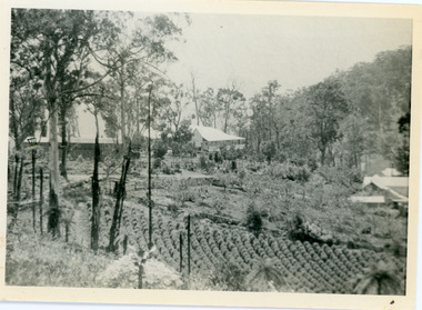
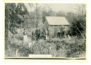
Photograph
The Keoghs took up Lot 7 in the Village Settlement in 1905. John Keogh was a big Irishman and cleared many of the giant trees on his Lot 7. They had little water for their crops so grew gooseberries and red currants rather than the more valuable strawberries. Mrs Keogh (nee Cleary) inherited money in 1906 and they built a new weatherboard house. The original bush hut remained as the kitchen. Son James (Jimmie) married Mary Walsh, a teacher at the local school. Jimmie built the small shop on the triangle of land cut off when the CRB road went through. Jimmie and his wife left the district when he joined Victoria Police. Jimmie came back to the area and finally sold the land of Lot 7 to Rimington's Nurseries. He moved his family to Kilsyth. In 1939 the shop was moved across the road to be used as an office by the road builders. It burned down that year.Black and white photograph of a man, woman and young male standing outside a wooden hut. There are crop remnants in the foreground and a wooden paling fence behind the hut. A label on the front reads A SETTLER'S HUT. Reverse of photograph has handwritten description by John Lundy-Clarke.Front: A SETTLER'S HUT Reverse: 1905 Keogh's hut on Falls Road then Main Road. This was later the kitchen of their extended home as described in the narrative "Mountain of Struggle". The figures are - Mrs Keogh. John Keogh settler. Son James Keogh.keogh, john keogh, james keogh, jimmie keogh, mary walsh, cleary, shop, store, gooseberries, rimington's nursery -
 Mt Dandenong & District Historical Society Inc.
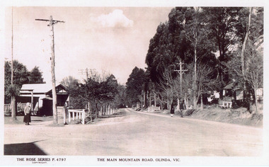
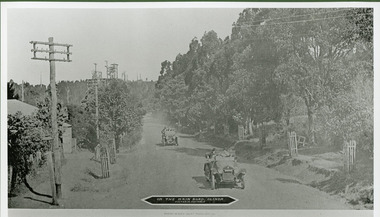
Photograph, The Main Mountain Road, Olinda, c1940
... Office postcard olinda Main Road Copy of Rose Series Postcard ...Copy of Rose Series Postcard #4797Copy of Rose Series Postcard #4797. View down Main Road Olinda towards Sassafras c1940s showing Post Office to the left.Three people visible in picture.rose series, post office, postcard, olinda, main road -
 Mt Dandenong & District Historical Society Inc.
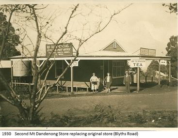
Photograph, Mt Dandenong Store, 1930
Image shows the Mt Dandenong Store and Post Office that replaced the former Post office and Store that was located on the corner of Old Coach and Farndons Roads. The store relocated following the opening of the new Main Road in 1926. The store pictured was on the corner of Helen Street and the Main Road. The image was taken in 1930. The photograph was taken by a member of the Dower family.Donated as a jpeg digital image that shows the Mt Dandenong Store on the corner of Helen Street and the Main Road in 1930. Two women and a man are standing at the front. Signs advertising the Store & Post Office, Age and Argus are clearly visible on top of the verandah.Front of image: 1930 Second Mt Dandenong Store replacing original store (Blyths Road)mt dandenong, post office, store, mt dandenong store, main road -
 Mt Dandenong & District Historical Society Inc.
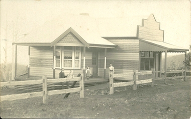
Photograph, Mt Dandenong Store, c1912
The Mt Dandenong Post Office & Store was originally built by Will Dower. The house and shop was built in 1912 and staffed by Ruby and Ada Dower. It became the Post Office in 1917 when Lil Badenhop sold her business following the death of her daughter Myrtle. The Post Office and Store closed in 1926 when the new premises opened on the Main Road.Black & white photograph of Dower's house and shop built on the corner of Old Coach Road and Farndons Road in Mt Dandenong. A man, woman and two children are in the foreground. Donated as a jpeg digital image.dower, will dower, mt dandenong, mt dandenong store, mt dandenong post office, mount dandenong post office, lil badenhop -
 Mt Dandenong & District Historical Society Inc.
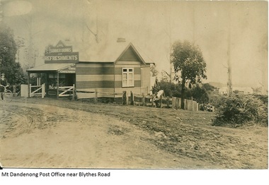
Photograph, Mt Dandenong Post Office Near Blythes Road
The Mt Dandenong Post Office & Store was originally built by Will Dower. The house and shop was built in 1912 and staffed by Ruby and Ada Dower. It became the Post Office in 1917 when Lil Badenhop sold her business following the death of her daughter Myrtle. The Post Office and Store closed in 1926 when the new premises opened on the Main Road.Black and white photograph of Dower's house and shop built on the corner of Old Coach Road and Farndons Road in Mt Dandenong. A boy with a bicycle can be seen at the LHS edge of the photograph and the Mt Dandenong State School building directly behind the shop.dower, will dower, mt dandenong, mt dandenong school, mt dandenong store, mt dandenong post office, ruby dower, ada dower -
 Mt Dandenong & District Historical Society Inc.
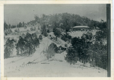
Photograph, Kalorama Gap Under Snow 1921, 1921
... Dandenong North Post Office. The old Main Road runs up the centre... was the Mount Dandenong North Post Office. The old Main Road runs up ...View of Kalorama Gap under snow taken in 1921. Mountjoy Guest House is at top right and Beulah Tea Rooms is in the centre. This photograph has a detailed inscription on the back handwritten by John Lundy-Clarke in 1974.Kalorama Gap under snow 1921 The leafless elm trees are low in the centre and the dual nature of the nearer one can be clearly seen, two small suckers of the older farther tree being twisted together in 1898 by Fred Jeeves. The older tree was planted 1880. Mrs Hands shop can be clearly seen, which was the Mount Dandenong North Post Office. The old Main Road runs up the centre of the picture and turns to the right and disappears behind “Mountjoy” the big guest house built by Paynters in 1905 and sold to Ellis Jeeves 1908, whose family ran it till 1943. At the bend of the road behind the big pine tree and the dark blackwood can be seen faintly the gable of Price’s house that contained the first shop on the mount. Above it is H Walker’s cottage on Ridge Road that still exists, his homestead is on the left of the picture on the same level. Below this house and to the left can be seen Ted Prices hay and corn store. The present estate agency lies between these two buildings, on the road which had recently been built. This can be seen winding from the lower left corner of picture to the left of the elms. The CRB had recently fenced the road and this is clearly seen as it circles behind trees in the left centre. Barber’s Road crosses CRB Road to the left of the dray under the leafless elm and the Coach Road dives down to the right just behind the pair of blackwoods to right of the elms. The picture was taken from just above the boundary of Isaac Jeeves’s selection Crown Allotment “C” (Jeeves Saddle) which stretched across the Gap to the other side of Mrs Hand’s shop, monopolising the gap from 1871 to 1879. Price’s house remains partly as the small house – “Mirra Laken”. kalorama gap, fiveways, post office, mountjoy, guest house, snow -
 Mt Dandenong & District Historical Society Inc.
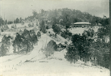
Photograph, Post Office and 'Mountjoy', Mt. Dandenong North, 1913
Rose Series post card #182Copy of Rose Series postcard #182 showing Kalorama Gap in 1913. Haystacks in foreground with Mountjoy Guest House and Beulah Tea Rooms/Mt Dandenong North Post Office in centre. This photograph has a detailed inscription on the back handwritten by John Lundy-Clarke in 1974.Kalorama Gap in 1913 The elm trees are in the centre of the picture. One of these is really two as two suckers of the further tree were twisted together by Fred Jeeves in 1898 and grew as one tree. The other was planted in 1880. The shop is the shop of Mrs Eliza Hand and daughter Florence. The closed in far end of the verandah was the Mount Dandenong North Post Office. The large house is “Mountjoy” owned and run by the Jeeves Family from 1908 till 1943. It was built in 1905 by the Paynters who sold to Ellis Jeeves in 1908.He moved his line of coaches from “Kalorama” his old homestead and housed the horses in a line of stables behind “Mountjoy”. Price’s house, which contained their shop, the first one on the mountain, opened 1906, can be seen faintly behind the pine tree opposite the bend in the road, which was the main road then and now is Ridge Road. The Price’s house just shows in two tiny pieces, one on each side of the pine tree half way up. The house to the right of and high up the pine tree is Walker’s cottage which exists today opposite Jack Kidd’s home at the far edge of Lt 2 Village Settlement and was between Main Road and Barbers Road which runs down the left behind the elms. Walker’s homestead can be seen near left edge of picture 2/3 way up. The roof of the Methodist Church shows among trees left of picture. This, like Mrs Hand’s shop was built on portions separated from Isaac Jeeves’ Selection “C” known as Jeeves Saddle. kalorama gap, five ways, mountjoy, john lundy-clarke, beulah tea rooms, post office, fred jeeves, paynter, jeeves, frederick jeeves, price, walker, jack kidd -
 Mt Dandenong & District Historical Society Inc.
Photograph, The Gap Under Snow 1921, 1921
Snow scene looking up through The Gap (FiveWays) with Mountjoy Guest House on the hill to the right. The shop and post office are seen in the centre of the picture. This photograph has a detailed inscription on the back handwritten by John Lundy-Clarke in 1974.The Gap under snow 1921. “Mountjoy” on hill. New CRB road formation (unmetalled) comes into picture lower left corner, passes left of dray under the elms, then circles around behind the trees behind Miss Hands shop and home and Post Office (Mt Dandenong North) to pass out of picture left in centre of picture. It passes between Ted Prices Hay & Corn store and Walker’s house where the Estate Agency was later placed. Main Road then in centre of picture bend right behind Mountjoy. Price’s house and shop behind the blackwood left of road bend. CRB cuts across Barbers left of Elm trees.john lundy-clarke, kalorama, mountjoy, mountjoy, the gap, post office, mt dandenong north, snow -
 Mt Dandenong & District Historical Society Inc.
Photograph, On The Main Road, Olinda, c1940
Copy of Photo Series Giant Postcard number 146Copy of Photo Series Giant Postcard # 146 showing the Main Road looking towards Sassafras with two cars coming towards the photographer. Old Post Office on the corner LHS. c1940olinda, transport, giant postcard -
 Mt Dandenong & District Historical Society Inc.
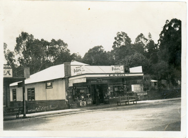
Photograph, Gill's Store Olinda, late 1920s
Small photograph showing E.M. Gill's Store in Main Street Olinda. As well as a general Store and Newsagency it served as the booking office for US Motors. There are no power poles so this dates the photograph as before 1927.Gill's Place handwritten on back of photograph.gills newsagency, us motors, general store, olinda -
 Mt Dandenong & District Historical Society Inc.
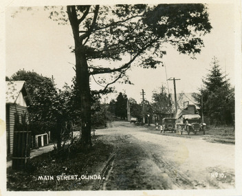
Photograph, Main Street, Olinda, c1930s
Number 10 in commercial seriesSmall photograph, number 10 in Olinda series, showing Main Street Olinda. View is looking NW from Olinda Monbulk Road towards Range Road. Left hand building is old Olinda Post Office. Ice truck is outside shops in distance and a delivery truck with tarp can be seen. c1930solinda, post office, truck -
 Southern Sherbrooke Historical Society Inc.
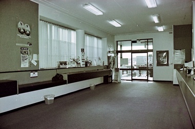
Photograph
B & W photo, Belgrave Post office 1997. Internal shot showing public area looking towards front door. Counters for public use and built-in seating seen on left side. 'Textile Offcuts' shop visible across Main Road. -
 Ballarat Tramway Museum
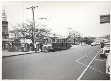
Photograph - Black & White Photograph/s, Andrew Howlett?, c1971
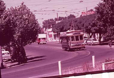
Yields information about the appearance and operation of the main tram stop in the City in Sturt St prior to closure.Black and White photograph print of tram 42 and another bogie car at the City terminus, south side of Sturt St, c1971. Tram has the destination of Sebastopol. The Ballarat Post Office is in the view.trams, tramways, sturt st, tram 42 -
 Ballarat Tramway Museum
Slide - 35mm slide/s - set of 4, Noel Simons, Apr. 1967
Set of 2 slides made from the Association of Railway Enthusiast Provincial Tramways film strip, possibly during April 1967. 1192.1 and 1192.3 mounted in Kodak Ready Mounts. The others in plain white mounts. Slides dated Dec. 1968. 1192.1 - No. 21 out bound to Golden Square in High St., between Wattle and Vine Streets. Photo taken after tram has passed photographer. Has a sign for "Reid's Furnituorium" in the background. 1192.2 - Bendigo No. 28 dressed up as Myers Christmas tram, passing the Post Office and Courts in Pall Mall. 1192.3 - Bendigo No. 23 at Needle Loop en route to Eaglehawk. Tram has two SEC roof ads, one "Electric Cooking" and the other "Everything fine in my all electric kitchen". 1192.4 - Bendigo scrubber parked at the end of the main depot lead, alongside the depot office buildings.Details in blue ink, date hand stamped in purple ink. 1192.1 - "No. 21 heads along High St for Golden Square between Wattle and Vine Streets." 1192.2 - "Birney No. 28 in Christmas Garb, traverses Pall Mall en route to North Bendigo". 1192.3 - "No. 23 at Needle Loop on its run to Eaglehawk". 1192.4 - "Scrubber car at Bendigo Depot".tramways, trams, north bendigo, bendigo, bridge st loop, depot, tram 21, tram 23, tram 28, tram scrubber -
 Ballarat Tramway Museum
Slide - 35mm slide/s - set of 2, Peter Moses, Jan. 1966
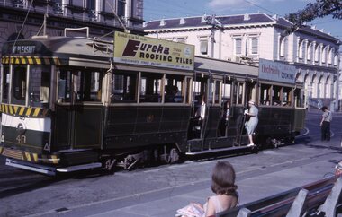
Photo of SEC Ballarat Tram No. 40 at the City terminus in Sturt St. at Lydiard St. Tram has destination of "Mt Pleasant" and roof advertisements for Eureka roofing tiles and SEC "Electricity Best for Cooking". In the background are the Post Office and the ANZ bank buildings. The driver and conductor appear to be looking at the points. 2041.1 - with lady boarding the tram 2041.2 - with conductor returning to the tram. All of the tram in the photo. Note lady on the seat. Kodak cardboard mount slide, taken by Peter Moses January 1966.On back of both slides in blue ink "Jan. 1966 “Main St.” Ballarat No. 40 / 125 f11" and in bottom right hand corner "P. Moses".tramways, trams, city terminus, sturt st, tram 40 -
 Ballarat Tramway Museum
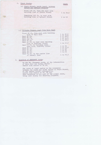
document - Typed Notes, "Track Grades" and "Tramway Route Distances", 1953
Yields information about the curves and grades and track distances in Ballarat on its tramways.Typed notes titled 1. - "Tramway Route Distances" detailing the distances in Ballarat over the various routes and within the city, often measured from building lines, provided in chains. Typed 12/3/1953, initials "WM" 2 - "Track Grades" - for Sturt St, South track between Albert and Lydiard St (south side), North side (between Courier Office and Lydiard St", Victoria St, east from Main Road, location of sharpest curve (Main Road into Barkly St), Dawson St crossover, Contained within Reg Item 5507 - Foolscap binder with green covers, black binding edge and metal clips. track, ballarat -
 Ballarat Tramway Museum
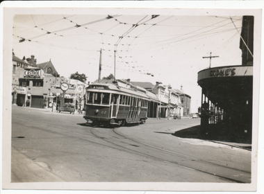
Photograph - Digital image, Wal Jack, 29/12/1945 12:00:00 AM
... out of Bridge St into Main St, Ballarat East Post Office... East Post Office in background in Main St. 29-12-45 ...Yields information about the early use of Ballarat's first bogie tram after it had been re-numbered and Stones Corner.Digital image from the Wal Jack Ballarat Album of No. 22 turning from Bridge St into Main St 29-12-1945. Has the Castrol / Caltex service station with clock in the background and Stones Corner building. Tram proceeding to Mt Pleasant. See image i2 for rear of photograph. See image i3 for hi res scan of print. See image i4 for hi res scan of negativeIn ink on rear " SEC Ballarat Tramways bogie. 22, turning out of Bridge St into Main St, Ballarat East Post Office in background in Main St. 29-12-45" with number "T547" within Wal Jack photo stamp.trams, tramways, bridge st, stones corner, main st, bogie trams, tram 22