Showing 2734 items
matching maps of goldfields
-
 Federation University Historical Collection
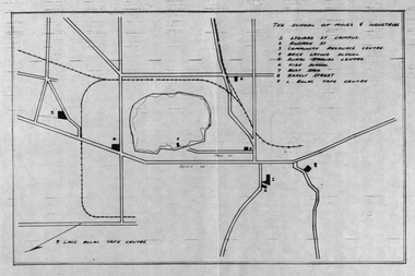
Plan, School of Mines and Industries: Location of buildings, Ballarat
Printed map showing Ballarat School of Mines locations.ballarat school of mines, plan, ballarat, lake wendouree -
 Federation University Historical Collection
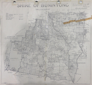
Map, Shire of Buninyong, c1970
The Shire of Buninyong was located on the southern side of Ballarat.Two maps of the Shire of Buninyong. .1) Map showing the County divisions, township boundaries, Railway line, State Forest boundary, riding boundary and shire boundary. Identifying words have been added in red and green texta. .2) Shire of Buninyong Parish Plan. Includes Buninyong, Clarendon, Narmbool, Enfield, Lychfield, SCotchman's, Navigators, Warrenheip, Scotsburn, mr Doran, Durham Lead, Cambrian Hill, Napoleons, Garibaldi, Mt Clear, Lal Lal, Bonshaw.1) B.I.A.E., St Martin's, cemetery, mt Buninyong, mt Innes, rly stn shire of buninyong, buninyong, clarendon, narmbool, enfield, lychfield, scotchman's, navigators, warrenheip, scotsburn, mt doran, durham lead, cambrian hill, napoleons, garibaldi, mt clear, lal lal, bonshaw, state forest, elaine, elaine north, cargerie, grenville, mt mercer, millbrook, wallace, yendon, canadian, kaolin deposits, mount helen campus -
 Federation University Historical Collection
Booklet, Northern Territory ... The Tanami Gold Country with Plans, 1909, 1909
Pink foolscap report of 12 pages, includes geological map from Pine Creel to Sturt's Creek by H.Y. L. brown; geological map between Mucka and Gordon Downs Station and Tanami by W.R. Murray; geological map of Tanami and surrounding country by W.R. Murray, and Plan of Lawne's Gold Prospecting Claim at Tanami by W.R. Murray pine creek, sturt's creek, tanami, northern territory, tanami gold country -
 Federation University Historical Collection
Booklet - Handbook, School of Mines and Industries Ballarat - TAFE training that works, 1996/1997
Booklet with information for prospective students regarding courses available, entry requirements, employment opportunities, duration and mode of study, and how to apply as well as fee information, maps, information to help you study etc. .1 - 1996 .2 - 1997tafe training that works, ballarat school of mines and industries, ballarat school of mines, prospective students, fees and charges, entry requirements, how to apply, courses -
Federation University Historical Collection
Booklet, Buninyong Heritage Walks and other Interesting Cycle Rides and Scenic Drives, 2008
Blue soft covered book, with maps, plans and photographs relating to Buninyong, Victoria. buninyong, de soza park, buninyong tannery, buninyong railway station, eagle hotel, old buninyong library, hastie's hill, buninyong town hall, hastie's spring, crown hotel, buninyong post office, bowen tree, aborigines, buninyong primary school, buninyong cemetery, gold monument, mount buninyong, lal lal falls -
 Federation University Historical Collection
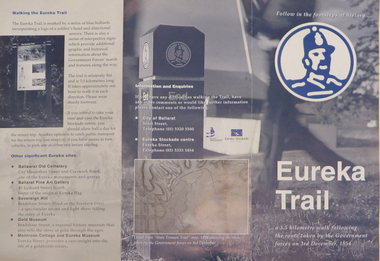
Brochure, Eureka Trail, c2000
The brochure gives information on the Eureka Stockade which took place on 03 December 1854. The Eureka trail aimed at enhancing the Eureka experience and was developed in 1996. It was managed by the City of Ballarat with funding assistance form the State and Federal governments. Much of the work was undertaken under the New Work Opportunity Programme.Blue and white brochure highlighting relevant Eureka Stockade site. The brochure includes a map showing the route the Government forces took on their way to the Eureka Stockade as well as sites of interest to Eureka which are marked by blue bollards. The brochure was presented by the City of Ballarat and the Eureka Stockade centre.eureka, eureka stockade, diggers' trail, trooper's trail, eureka stockade centre, city of ballarat -
 Federation University Historical Collection
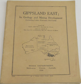
Book, Gippsland east: its geology & mining development, 1936
Soft brown covered book of 45 pages about East Gippsland mining and development. Includes map of Gippsland East, Lakes Entrance. Includes Lakes Entrance, Metung, Beng Worden, Bairnsdale, Longford, Torquay.gippsland east, gippsland, geology, mining, mines department, geo. brown, e.j. hogan -
Federation University Historical Collection
Booklet, Ballarat School of Mines Botanical Gardens Conservation/Restoration Management Plan
A Conservation/Restoration Management Plan for the Ballarat School of Mines Botanical Gardens. The report includes a planting timeline of the plants included in the gardens from 1850. Historical plans and maps are detailed from 1857 up to the site assessment in 2008.Printed report stapled at top left corner.Lisa Palmer written at top right corner in pencil.smb, school of mines ballarat, ballarat school of mines, botanical gardens, smb botanical gardens, conservation, restoration, ballarat school of mines garden, von mueller garden, ferdinand von mueller, botany, living collections, horticulture, gardens -
 Federation University Historical Collection
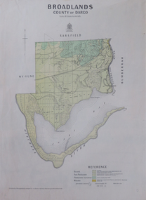
Map, Broadlands, County of Dargo, 1887
Plan of Broadlands, County of Dargo, Victoria.broadford, j.g. easton, dargo, geological -
 Federation University Historical Collection
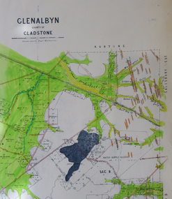
Map, Glenalbyn, County of Gladstone
Copy of a geological map of Glenalbyn. Some areas have been colours green. Creeks have been coloured blue, roads and reefs have been coloured orange.glenalbyn, county of gladstone, tarnagulla, inglewood, kingower, kurting, old inglewood deep lead, salisbury west -
 Federation University Historical Collection
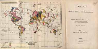
Book, Geology, Chemical, Physical, and Stratigraphical, 1886
These books were added to the library of the School of Mines Ballaarat in 1889. The author was Joseph Prestwich, who was a Professor of Geology at the University of Oxford.Two brown hard cloth covered books, Vol 1 & vol 2 with gold printing on the front cover and on the spine. .1) has a coloured fold out map of the World opposite the title page .20 has a coloured fold out map of Europe..1) A label is attached to the inside front cover with The School of Mines Ballaarat and the no. 955 and date purchased 14/3/89 (1889) as well as the institutions stamp in several places throughout the book. .2) As above but with no. 956 and on the inside fly is written in pencil 'Stamped in Error' with a Ballarat School of Mines Student Library stamp crossed out.geology, bookplate, library plate, ballarat school of mines library, joseph prestwich, geological map of the world, geological map of europe, hieropolis thermal springs, rockss, ice, volvanoes, earthquakes, metallurgy, shakespeare's cliff dover, wapley, gloucestershire, redruth mining district, fossils, reptilian footprints, chalk, london clay -
 Federation University Historical Collection
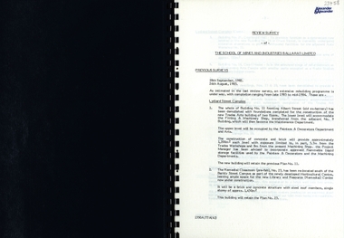
Report, SMB: Review Survey of Buildings and Grounds, July 1985, 1985
Report of the detailed review of The School of Mines and Industries Ballarat Limited undertaken by Alexander & Alexander in 1985. Previous reports were done in 1982 and 1983. The report covers all areas of the school - buildings and grounds. Some sections/buildings are still being completed. Report contains written evaluation, maps/diagrams and photographs.Spiral bound book - dark blue cover. 15 pages of written information plus 3 pages of photographs.Gold lettering on from cover "Alexander & Alexander" Signature "J W Elliott" on page 10 (Loss Control Surveyorballarat school of mines and industries, survey, alexander and alexander, j w elliott, maps, photographs -
 Federation University Historical Collection
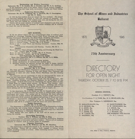
Programme, School of Mines: 75th Anniversary, Directory for Open Night, 1945, 1945
To celebrate the 75th Anniversary of the School of Mines and Industries an Open Night was held on Thursday, October 25 (1945) from 7 to 9.15 p.m. The Principal was Mr A Heseltine and the Registrar was Mr F Ferguson. Members of the School Council included E J Tippett, M G Beanland who have a building or walkway named after them. A map of the buildings shows the various areas and information is given for each department. Though it was an Open Night it would also serve as an Information Night for student enrolling for the following year.Paper folded in half and printed on each of the four sections. Map showing layout of buildings. Information on each department of the school.ballarat school of mines and industries, 75 anniversary, a heseltine, principal, f e ferguson, registrar, e j tippett, m g beanland, open night, information night -
 Federation University Historical Collection
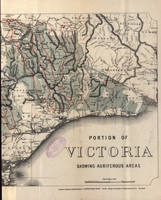
Map - Map and Information, Department of Mines: Map and Suggestions to Prospectors, 1891
... E.J. Barker Library (top floor) Mount Helen goldfields The map ...The map outlines the auriferous (gold bearing) areas in Victoria. The information for prospectors was prepared by the Department of Mines in 1894Document: 4 page type written Map: Portion of Victoria divided into Counties of 1891. Auriferous areas with red.Reference section on mapgold, auriferous areas, department of mines, victoria, map of victoria, prospectors, commissioner of crown lands, hon a mclean, alexander black, surveyor general, a mclean -
 Bendigo Historical Society Inc.
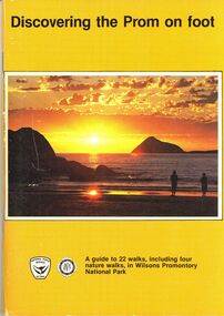
Book - STRAUCH COLLECTION: DISCOVERING THE PROM ON FOOT
Discovering the Prom on foot, a guide to 22 walks, including four nature walks, in Wilsons Promontory National Park, a joint publication of the National Parks Service, Victoria and the Victorian National Parks Association, 64 pages with black and white photograpgs, illustrations & maps.place, land, wilsons promontory, victoria-national parks- nature walks -
 Bendigo Historical Society Inc.
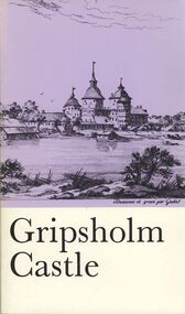
Book - STRAUCH COLLECTION: GRIPSHOLM CASTLE
Gripsholm Castle official illustrated guide, published by the National Museum, Stockholm. Editor: Ulf.G.Johnsson, 54 pages with black and white photographs, illustrations & maps.place, building, castle, sweden - stockholm - castles - museums -
 Bendigo Historical Society Inc.
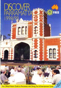
Book - STRAUCH COLLECTION: DISCOVER PARRAMATTA
Discover Parramatta 1998/99 your official visitors guide to Parramatta with dining out & entertainment guide with photographs and a map.australia, history, parramatta, australia - history - nsw - parramatta -
 Bendigo Historical Society Inc.
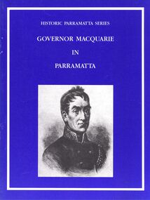
Book - STRAUCH COLLECTION: GOVERNOR MACQUARIE IN PARRAMATTA
Booklet, Historic Parramatta Series Governor Macquarie in Parramatta, with black and white photographs and a map.australia, history, parramatta, australia - history - nsw - parramatta -
 Bendigo Historical Society Inc.
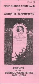
Document - BENDIGO CEMETERIES COLLECTION: SELF GUIDED TOUR NO. 8 DOCUMENT
Pink document trifold. Self Guided Tour No. 8 of White Hills Cemetery, Friends of the Bendigo Cemeteries 2002 - 2003. Theme of tour 'Symbolism in White Hills Cemetery' Map with numbered grave sites.Friends of Bendigo Cemeteries 2002bendigo, cemetery, white hills cemetery tour -
 Bendigo Historical Society Inc.
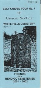
Document - BENDIGO CEMETERIES COLLECTION: SELF GUIDED TOUR NO.7 DOCUMENT
Blue coloured document, trifold. Self Guided Tour No. 7 of Chinese Section, White Hills Cemetery, Friends of the Bendigo Cemeteries 2-001 - 2002. Theme 'A hundred years after Federation' Map with numbered grave sites, with descriptions e.g. Louey Ah Pon, passenger involved in a fatal car accident with a bus on High St., a market gardener of Golden Square. Chung Fook Jao, committed suicide in his hut on the New Chum Mine site where he had worked the tailing for many years.Friends of the Bendigo Cemeteries 2000bendigo, cemetery, white hills cemetery tour -
 Bendigo Historical Society Inc.
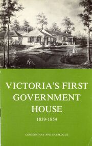
Book - STRAUCH COLLECTION: VICTORIAS FIRST GOVERNMENT HOUSE
Booklet, Victoria's First Government House 1839 - 1854 Commentary and Catalogue Fourth edition 1974 National Trust of Australia. Contains black and white photographs and a map.australia, history, government, australia - history - government -
 Bendigo Historical Society Inc.
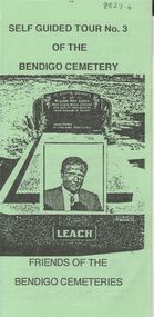
Document - BENDIGO CEMETERIES COLLECTION: SELF GUIDED TOUR NO. 3 DOCUMENT
Blue coloured document trifold: Self Guided Tour No. 3 of the White Hills Cemetery, Friends of Bendigo Cemeteries 1996 - 1997.Photo of John Gerber headstone on cover. Map of cemetery with numbered grave sites and descriptions of same. E.g. Ed Jackson, blinded in mine accident, cricketer H. Boyle arranged benefit football match Carlton versus Melbourne, 1st time for an entry charge to a football match. J.C. Murray, 200 pounds remittance man, died of indulgence of spirits.Friends of Bendigo Cemeteries In 1996bendigo, cemetery, white hills cemetery tour -
 Bendigo Historical Society Inc.
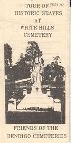
Document - BENDIGO CEMETERIES COLLECTION: SELF GUIDED TOUR HISTORIC GRAVES WHITE HILLS CEMETERY DOCUMENT
Lemon coloured trifold document : Tour of Historic Graves at White Hills Cemetery. Friends of the Bendigo Cemeteries. Map of White Hills Cemetery (1854 - 1993 ) showing marked grave sites with descriptions. E.g. Charles Merri Bux - 'Black Charlie' Indian hawker of Bendigo. History of White Cemetery on back page.Friends of Bendigo Cemeteriesbendigo, cemetery, white hills cemetery -
 Bendigo Historical Society Inc.
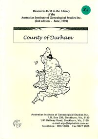
Book - STRAUCH COLLECTION: COUNTY OF DURHAM
Booklet Resources Held in the Library of the Australian Institute of Genealogical Studies Inc. (2nd edition - June, 1998) County of Durham, 20 pages with a map.genealogy, family, durham, uk-durham-genealogy -
 Bendigo Historical Society Inc.
Document - BENDIGO CEMETERIES COLLECTION: SELF GUIDED TOUR WHITE HILLS CEMETERY DOCUMENT
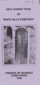
Lilac coloured trifold document: Self guided tour of White Hills Cemetery, Friends of Bendigo Cemeteries 1995. Map with numbered grave sites e.g. Large Jewish section with over 80 known burials. Graves of Afghan traders,Friends of Bendigo Cemeteries, 1995bendigo, cemetery, white hills cemetery tour -
 Bendigo Historical Society Inc.
Document - BENDIGO CEMETERIES COLLECTION: SELF GUIDED TOUR NO. 7 DOCUMENT
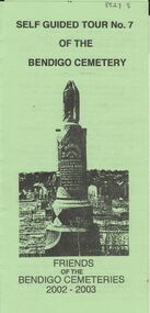
Green trifold document: Self Guided Tour No. 7 of the Bendigo Cemetery, friends of the Bendigo Cemeteries 2002 - 2003. Theme is tombstones erected not by family but by public subscriptions or through societies. Numbered map showing described grave sites.Friends of Bendigo Cemeteries 2002bendigo, cemetery, bendigo cemetery tour -
 Bendigo Historical Society Inc.
Document - BENDIGO CEMETERIES COLLECTION: SELF GUIDED TOUR NO. 6 DOCUMENT
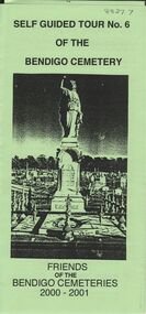
Green trifold document: Self Guided Tour No. 6 of the Bendigo Cemetery. Friends of the Bendigo Cemeteries 2000 - 2001. Theme : Federation: 100 years later, our Heritage. Map with 26 numbered graves, includes J.C.T. Ballerstedt, Christiana Atkinson ( Dr. Atkinson buried 4 wives in this cemetery ) John Dumphy miner of Hustler's reef, erected by Bendigo Miners Accident Society.Friends of the Bendigo Cemeteries Inc 2000bendigo, cemetery, bendigo cemetery tour -
 Bendigo Historical Society Inc.
Document - BENDIGO CEMETERIES COLLECTION: SELF GUIDED TOUR NO. 5 DOCUMENT
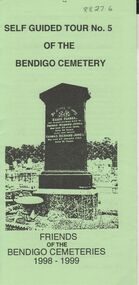
Green trifold document: Self guided tour No. 5 of the Bendigo Cemetery, Friends of the Bendigo Cemeteries 1998 - 1999' Map of cemetery with numbered graves. Theme 'Heritage all around us'Friends of the Bendigo Cemetery 1998bendigo, cemetery, bendigo cemetery tour -
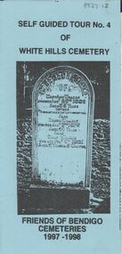
 Bendigo Historical Society Inc.
Document - BENDIGO CEMETERIES COLLECTION: SELF GUIDED TOUR NO. 4 DOCUMENT
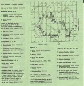
Green trifold document: Self Guided Tour No. 4 of the Bendigo Cemetery, Friends of the Bendigo Cemeteries 1997. Map of Bendigo Cemetery with numbered grave sites. Theme : National and religious diversity. Text on back describes how early colonists arrived with different religions, languages, social habits etc Sandhurst Cemetery Register recorded denomination not nationality, but noted if the dead person was coloured.Friends of the Bendigo Cemeteries Inc 1997bendigo, cemetery, bendigo cemetery tour -
 Bendigo Historical Society Inc.
Document - BENDIGO CEMETERIES COLLECTION: SELF GUIDED TOUR NO.3 DOCUMENT
Green trifold document: Self Guided Tour No. 3 of the Bendigo Cemetery. On front, headstone image of William Roy Leach. Map of cemetery with numbered graves described e.g. Lady Jane Lamsey, honoured by Emperor of Chinese , Oscar Flight, Flight's Band 80 years dedicated to music. On back fold: this tour takes you past graves of some of Roy's old friends, as well as neglected graves, some bearing family names still found in the business directories of BendigoFriends of the Bendigo Cemeteries Inc. 1 May 1994.bendigo, cemetery, bendigo cemetery tour