Showing 116789 items
matching orbost-brodribb-road
-
 Eltham District Historical Society Inc
Slide, Post drainage repairs on Bonds Road near Martin property and Montpelier Drive, Lower Plenty, c.July 1972, 1972
Water drainage work undertaken by Eltham Shire Council in Bonds Road, Lower Plenty outside the Martin property opposite Montpelier Drive, July 1972 35 mm colour positive transparency Mount - Agfacolor Service (Blue)Bonds Road (Martin property) 12.10 pm 18.7.72bonds road, drainage works, eltham shire council, infrastructure, lower plenty, martin property, montpelier drive -
 Kew Historical Society Inc
Photograph, Stuart Tompkins Studio, Electricity Supply Poles, Warrigal Road, Holmesglen, 1965
Research provided by Stuart Tompkins Studio, Box Hill, into alternatives for median strip street lighting to be used in Burke Road, Kew. The photographers identified variants in different suburbs appropriate to Kew's needs. The series from which the photograph is drawn provides a snapshot by a commercial photographic studio of each named vicinity in 1965 as well as providing examples of public works infrastructure being commissioned by local government in the 1960s. The photos originally formed part of the Engineering Department's files in the City of Kew before being donated to the kew Historical Society.Electricity Supply Poles, Warrigal Road, Holmesglen, 1965. Stuart Tompkins Studio provided this photograph for the Kew City Council. The photograph of Warrigal Road, north of Holmesglen looking north depicts wooden poles with bracket light fittings. These were the same as those proposed for Kew, except the lights and fittings were not to be 350 watt. Mercury lamps were preferred. [There are three copies of this photograph in the Collection.] Typed inscription on reverse: "Electricity Supply Poles. Photographed for Kew City Council 8/2/65. No.3 Warrigal Road - North of Holmesglen looking north. Wooden poles with bracket fittings same as those proposed for Kew except lights and fittings are not for 250 watt c. c. mercury lamps proposed. Wooden pole 3' up 11 3/4" dia." Studio stamp: "Stuart Tompkins Studio. 547 Station Street, Box Hill. WX1439."stuart tompkins studio, warrigal road (holmesglen) 1965, street lighting -
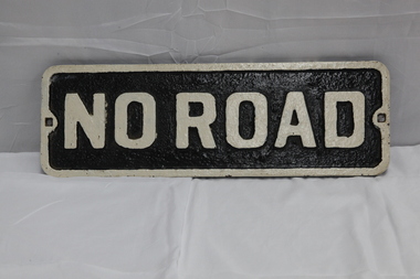 Puffing Billy Railway
No Road - End of platform sign
Historic - Railway - No Road Plate Sign Historic - Railway - No Road Plate Sign No Road Plate Sign Long rectangular plate that has been painted black and white with the words "no road" written across it. made of cast metal"No Road"puffing billy, sign, plate, no road sign -
 Stawell Historical Society Inc
Photograph, Water storage tanks part of reservoir in reefs road -- Coloured
Coloured Photo showing two water storage tanks part of reservoir in reefs roadDirt road in foreground power pole and water tanks. stawell -
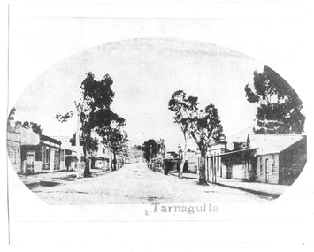 Tarnagulla History Archive
Photograph of Commercial Road, Tarnagulla looking south from King Street, Commercial Road, Tarnagulla Looking South from King Street, c1930, circa 1862 - 1900
Murray Comrie Collection. This is a reasonable copy of an older original. Copy probably made by Murray Comrie in the 1970s. Monochrome photograph. View of Commercial Road Tarnagulla looking south from around King Street. At right is Victoria Hotel next to a weatherboard building at far right.Printed caption on original is 'Tarnagulla'.tarnagulla, commerce, stores, shopping, shops, hotels, victoria hotel and theatre, buildings, commercial road, main street -
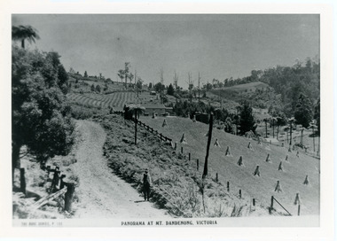 Mt Dandenong & District Historical Society Inc.
Photograph, View From Corner of Doughty's Road and Barbers Road 1913
John Lundy-Clarke grew up in the Kalorama/Mt Dandenong area and later in life (1972-74) began to write a comprehensive history of the area working from an original settlement map in an effort to cover all areas. Taken c1913, this photograph gives a clear indication of where significant buildings were located in relation to one another. Barbers Road is running through the picture with the guest house 'Kia-Ora' , built by George Barber in the centre. High on the skyline on the left is the 'Mountjoy' guesthouse, indicating the location of The Gap, or FiveWays. The small 'boxy' house above 'Kia-Ora' is 'Iona' built by the Paynter family who also built 'Mountjoy'. The Jeeves property 'Kalorama' is to the right of 'Iona' and this is the area you now look to from the FiveWays Lookout. The man in the photo is wearing a trilby hat so is probably a Rose Series employee - a feature in many Rose Series postcards.Black and white photograph that is a copy of Rose Series Postcard # 156. A man can be seen walking down an unmade road with haystacks to his right. Buildings and crops can be seen on the hillsides. Handwritten inscription on reverse by John Lundy-ClarkeView from corner of Doughty’s and Barbers Road 1913. “Kia Ora” in centre Paynter’s “Iona” near center skyline above “Kia Ora” with “Kalorama” on its right and Peter’s hut of the time below it among orchard trees. “Mountjoy” is on left skyline. W. Haye’s home is centre left. Hay paddock is Barbers Lot 25 Village Settlement.kia-ora, iona, kalorama, mountjoy, guesthouse, guest house, barbers road, doughty's road, paynter, jeeves, george barber -
 Eltham District Historical Society Inc
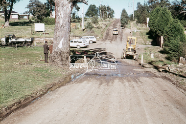
Photograph, Russell Yeoman, Para Road, c.1969, 1969c
Looking north from behind the Lower Plenty shops at Main Road and Para Road.Digital file only; created from original colour positive slide transparencystreets, lower plenty, para road, russell yeoman collection -
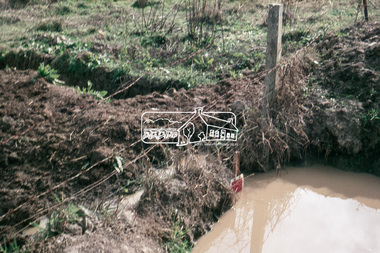
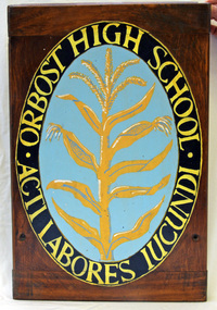 Orbost & District Historical Society
plaque, after 1948
The school badge was hand-painted on a wooden Art drawing board by an unknown student after the Higher Elementary School had been upgraded to a High School in 1948. The latin inscription, "Acti labores lucundi", can be freely translated as "Finished work is pleasant." The school badge, with its stalk of maize was designed by Clarke Cowell who was in the first Senior Class at Orbost Higher Elementary School in 1912. Clarke Cowell followed teaching as a career and was the first head teacher of the Corringle School, No. 4909, which opened on Feb 7 1921 and operated as a half-time school with the Marlo School No. 3433.Orbost High School / Orbost Secondary College has played a significant part in the education of senior students in the Orbost district . It is the sole senior educational institution. This uniform is representative of its history.A wooden rectangular plaque with a hanging wire attached to the back. It has an oval-shaped painted school emblem on a stained wood background. Around the circumference are the words ORBOST HIGH SCHOOL painted in yellow with the motto ACTI LABORES LUCUNDI. In the middle on a pale blue background is a painted gold stalk of maize. orbost-high-school education -
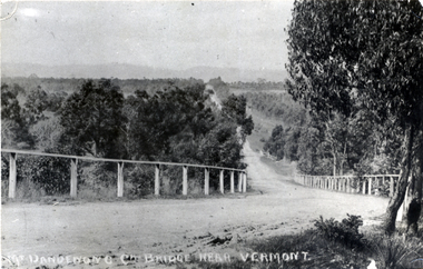 Whitehorse Historical Society Inc.
Photograph - Black and white photograph, Boronia Road, Vermont
Boronia Road Vermont approaching Dandenong Creek.Black and white photo of Boronia Road approaching Dandenong Creek, Vermontboronia road vermont, dandenong creek -
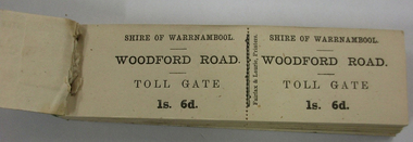 Warrnambool and District Historical Society Inc.
Functional object - Ticket Book, Fairfax & Laurie, Printers, Shire of Warrnambool, Woodford Road Toll Gate, 1s 6d, Circa 1866
In 1866, in an effort to maintain the main roads of the region it was decided to establish toll roads on the Belfast, Woodford, Purnim and Allansford roads. Gates were erected and the leases were disposed of by auction. In 1867 the Woodford tollhouse was destroyed by fire suspected to be deliberate. The tolls were removed three years later after much opposition.This item has historic significant as in the early years(1864) of Warrnambool Tolls were levied on the three main roads leading from Warrnambool into the Shire. In 1864 the Shire of Warrnambool decided that tolls were the only just way to raise funds for maintenance of metalled roads. the Shire of Warrnambool had been created in 1863 from the old Warrnambool Roads Board.Small booklet 140mms long by 40mms wide 13mm depth. Blue & grey marbled cardboard covers back & green oiled cloth binding. Inside full book of double side ticket stubs with perforations in the middle.Shire of Warrnambool. WOODFORD ROAD. TOLL GATE 1s. 6d. Fairfax & Laurie, Printerswarrnambool, shire of warrnambool, woodford road, main belfast road, toll gate, toll tickets, woodford toll house 1866, fairfax & laurie printers -
 Eltham District Historical Society Inc
Photograph, Looking east along Diamond Street to the railway crossing near intersection with Main Road, Eltham, February 1968, Feb 1968
Shows houses on Main Road and Cecil Street across Main Road from Diamond Street.In February 1968 an unknown person took a series of photos from the Eltham Hotel at Pitt Street heading north along Main Road through the shopping centre to just north of Elsa Court covering the length of the section of Main Road which was duplicated shortly thereafter. Shows the condition and environment of the streesscape of Main Road, Eltham immediately prior to the duplication between Pitt Street and Elsa Court through the shopping centre. Also shows a number of shops and businesses that operated at that time.Black and white photographduplication, eltham, main road, diamond street, railway line, railway crossing, cecil street, judge book village -
 St Kilda Historical Society
Photograph, St Kilda Road, c. 1960s
St Kilda Road (formerly High St), St Kilda. On right is corner of Alma Road. black and white photograph, original, unmounted, good condition -
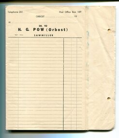 Orbost & District Historical Society
invoice forms, Snowy River Mail as "Mail" Print, 19th century
These invoice forms were to be used by Hector G. Pow's Sawmiller Company in Newmerella ( Henty's & Pow). Pow's had a mill at Cabbage Tree as well. The mill is currently owned by Mectec.Orbost has historically been based on the timber industry, but that industry has declined considerably over the last 20 years. The number of locals involved in the timber industry has declined and many of the mills have closed. This item reflects a time when that industry was a significant contributor to the economy of the district.Unused invoice forms for H.G.Pow Orbost Sawmillers. They are white paper with black print and lines. On the right hand side are two small holes for filing. The page is perforated with carbon underneath to provide two copies - one for filing and one for the customer. At the top of each page is "Telephone 201 Post Office 189 Orbost" and a line for the date. Below this is a line for the customer's name and "Dr to H.G. Pow (Orbost) Sawmiller". There are columns for item descriptions and costs.h.g.pow sawmills timber-orbost -
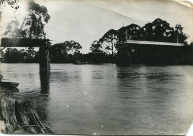 Orbost & District Historical Society
black and white photograph, January 1934
Damage estimated at £500,000 was caused by the 1934 floods in the Orbost district. This 1934 flood was devastating, destroying a section of the 1922 Orbost bridge, wrecking fences, bridges and roads, dumping silt and debris on the rich river flats and drowning cattle. The centre span of the Orbost Bridge was washed away. This item is a pictorial record of the 1934 floods, a significant part of Orbost's history.A black / white photograph showing the flood damage to the Snowy River Bridge. There is a gap in the bridge where the centre span has been washed away. In the background is a punt.orbost-floods-1934 natural-disasters-floods snowy-river-bridge -
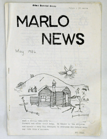 Orbost & District Historical Society
newsletter, Marlo News, May 1984
In small rural communities a community newsletter is an important tools for facilitating communication. It may also boost the local economy – both through advertising or news coverage.A newsletter, titled Marlo News. It contains articles, children's work, puzzles, events, a calendar, reports and black / white photographs. There are local advertisements. On the front cover is a sketch of an old school (Marlo?) below the heading MARLO NEWS and the cost -20 cents.On front cover - stamp of Orbost Historical Societymarlo-newsletter -
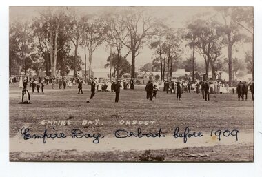 Orbost & District Historical Society
black and white photograph, C1909
The celebration of Queen Victoria's birthday on May 24 was renamed Empire Day in 1903 after her death in 1901. It was celebrated throughout the British Empire culminating in fireworks and bonfires in the evening. Empire Day was first introduced in 1905 to promote loyalty among the dominion countries of the British Empire. (from https://dictionaryofsydney.org/event/empire_day) Celebrated on 24 May, Queen Victoria's birthday, it was directed especially at school children. Teachers were encouraged to promote special steps to develop a feeling of pride in the British Empire and the achievements of the British race. Often a morning of short addresses, recitations and patriotic songs such as 'Rule Britannia' and 'Advance Australia' was followed by a half-day holiday to mark the celebration of Australia's strong ties to the British Empire. (from MuseumsVictoria)Empire Day was a celebration of the British Empire that was held for many years in the United Kingdom, Australia, Canada, and other countries. It took place every year on May 24, the date of Queen Victoria's birthday. Queen Victoria ruled England for 63 years. this item reflects the loyalty to and recognition of the British royal family in the first half of the 20th century.A black / white photograph of a large group of people , men in suits, women in long dresses. They are in a large fenced clearing.on back -" EMPIRE DAY ORBOST before 1909"empire-day celebrations gatherings public-events -
Lakes Entrance Regional Historical Society (operating as Lakes Entrance History Centre & Museum)
Photograph, 1/01/2006 12:00:00 AM
Built as tourist attraction on river at MarloColour photograph showing building of PS Curlip replica in old butter factory building Orbost Victoriatourism -
 Eltham District Historical Society Inc
Slide, Looking south along Bonds Road towards intersection of Montpelier Drive, Lower Plenty, 18 July 1972, 1972
Water drainage work undertaken by Eltham Shire Council in Bonds Road, Lower Plenty outside the Martin property opposite Montpelier Drive, July 1972 Note blocked table drains.35 mm colour positive transparency Mount - Agfacolor Service (Blue)Bonds Road (Martin property) 12.10 pm 18.7.72bonds road, drainage works, eltham shire council, infrastructure, lower plenty, martin property, montpelier drive -
 Greensborough Historical Society
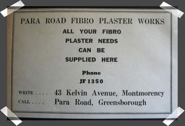
Advertisement - Digital image, Para Road Fibro Plaster Works, 1970s
Advertisement in the local paper for Para Road Fibro Plaster Works, of 191 Para Road Montmorency, 1970sPart of a collection of miscellaneous advertisements for businesses in Greensborough and surrounding areas.Digital copy of newspaper advertisement.para road fibro plaster works, para road montmorency -
 Ballarat Heritage Services
Photograph, The Deserted Great Ocean Road at Apollo Bay during the Covid 19 Lockdown, 20/09/2021
During the Covid19 Pandemic lockdowns resulted in empty roads. Colour photographs of plaques commemorating the opening of the Great Ocean Road, 2020great ocean road, plaque, apollo bay, david mclaren, pandemic, covid19 -
Ringwood and District Historical Society
Literary work - Biography, The story of Mrs McCann, 69 Warrandyte Road Ringwood dated December 1973, Dec-73
Written by Mrs. E. McCann. House was "Castle Crag" home of the A.T. Miles family 1916.The story of Mrs McCann, 69 Warrandyte Road Ringwood dated December 1973, 25 pages, started 8-Jan-1967 +Additional Keywords: McCann, Mrs. E. -
 Whitehorse Historical Society Inc.
Photograph, Canterbury Road in 1915, 1915
Part of Tim Shambrook's Collection for 'This is Vermont', P. 22.Black and white photo of Canterbury Road, Vermont, looking East, showing Mechanics Institute Hall which became Scout Hall. Old style street lamp in picture.vermont mechanics institute, mechanics institutes, vermont scout hall, shambrook, tim, scout halls -
 Eltham District Historical Society Inc
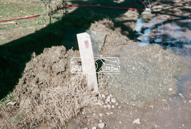
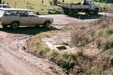
Slide, Pit on east side of Bonds Road, Lower Plenty, 18 July 1972, 1972
Water drainage work undertaken by Eltham Shire Council in Bonds Road, Lower Plenty outside the Martin property opposite Montpelier Drive, July 1972 Note rubbish excavated from pit.35 mm colour positive transparency Mount - Agfacolor Service (Blue)Bonds Road (Martin property) 12.10 pm 18.7.72bonds road, drainage works, eltham shire council, infrastructure, lower plenty, martin property, montpelier drive -
 Eltham District Historical Society Inc
Photograph, Main Road widening, Eltham, c.March 1968, 1968
Duplication of Main Road. Looking south from site of Eltham Shire offices towards Shillinglaw Cottage. Gahan house to left of Shillinglaw Cottage facing Main Road almost completely demolished. Main Road to the left and the Eltham Tip to the right.Digital file created by stitching two 35mm Colour positive transparency Mount - Agfacolor Service (Blue stepped)duplication, eltham tip, gahan house, main road, shillinglaw cottage -
 Whitehorse Historical Society Inc.
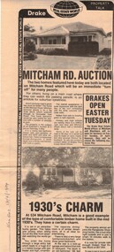
Newspaper, Mitcham Road auction, 01/04/1984,Nunawading
Advertisement for the sale of two homesAdvertisement for the sale of two homes, 265 Mitcham Road, Mitcham and 534 Mitcham road, Mitcham a 1930s timber home. Agent, drakes real estate. Photographs. Cutting from Nunawading Gazette, 18th April, 1984.Advertisement for the sale of two homesmitcham road, mitcham, no. 534, mitcham road, mitcham, no. 265, houses, drake & co. -
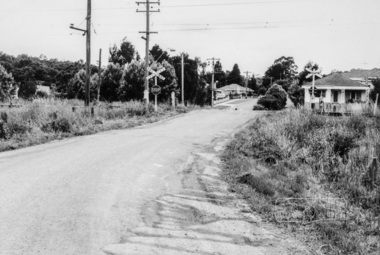
 Whitehorse Historical Society Inc.
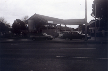
Photograph, The Railway Crossing from Corner of Springvale Road & Station, 1/06/2009
One of a collection of photographs taken of the Nunawading Railway Station prior to the lowering of the railway line and building of the new railway station on the western side of Springvale Road so that the Springvale Road Rail Crossing can be eliminated.Black & white photograph of he precinct surrounding the Nunawading Station and the Springvale Road Railway crossing. This photograph is of the Railway Crossing from corner of Springvale Road & Station. See NP 3545 to NP3567for the complete set of photographsnunawading railway station, springvale road, nunawading, redevelopment of railway line/springvale road., station street nunawading -
 Eltham District Historical Society Inc
Slide, In Bonds Road south of the northern arm of Montpelier Drive, Lower Plenty, 18 July 1972, 1972
Water drainage work undertaken by Eltham Shire Council in Bonds Road, Lower Plenty outside the Martin property opposite Montpelier Drive, July 1972 Note the blocked pit full of water and water circumnavigating the pit.35 mm colour positive transparency Mount - Agfacolor Service (Blue)Bonds Road (Martin property) 12.10 pm 18.7.72bonds road, drainage works, eltham shire council, infrastructure, lower plenty, martin property, montpelier drive -
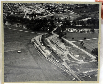 Orbost & District Historical Society
aerial photograph, 1970's
This photograph was taken prior to the closure of the Orbost -Bairnsdale freight line in 1987.The Orbost-Bairnsdale railway initially played a crucial role in developing agricultural industries in Gippsland as well as tourism. It opened in 1916 and operated until 1987, principally carrying timber and farming produce. In the early days of the railway's operation dedicated passenger trains ran but these ceased by the 1930s. The line was completely closed to freightage in 1987.The track infrastructure was dismantled in 1994 and has been redeveloped as the East Gippsland Rail Trail.A large black and white aerial photograph of Orbost Railway Station in the foreground and the Orbost township in the background. It has been pasted onto a piece of Masonite. railway photography orbost, railway photography orbost -
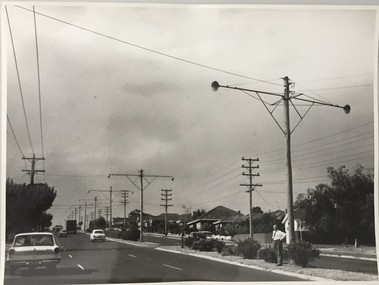
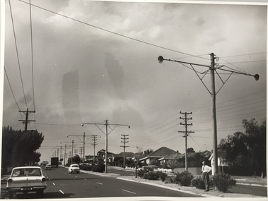
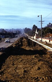 Surrey Hills Historical Society Collection
Photograph - Digital photograph, George L Coop, Whitehorse Road Mont Albert during road widening, 1958, c1958
The donor George Lister Coop was about 21 years of age when he took this photo in 1958 as Whitehorse Road was being widened. This was done in sections. It was taken from adjacent to the Coop family home at No.688. The house on the corner of High Street and Whitehorse Road (39 High Street) can be seen in the middle distance. A digital copy of a colour photograph of Whitehorse Road, Mont Albert looking towards Box Hill. The chimneys of Box Hill Gasworks can be seen in the distance. It was taken from adjacent to No 688.george l coop, whitehorse road, box hill gas works, mont albert, 39 high street, road works