Showing 2559 items matching "public halls"
-
 University of Melbourne, Burnley Campus Archives
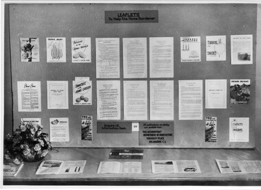
Photograph - Black and white print, Victorian Department of Agriculture, Display on Pruning Day, Unknown
Note by T.H. Kneen 13 May 1992, "One of many displays set up in the College Hall on the occasion of Public Fruit Tree Pruning Demonstrations."Black and white photograph. Display of leaflets providing information on fruit and vegetable growing available from the Victorian Department of Agriculture at a Pruning Day at Burnley.On reverse, "Photograph by Victorian Department Of Agriculture Ref. No. D.144.E."fruits, vegetables, pruning, fruit tree pruning demonstration, department of agriculture victoria, publicity, burnley college, leaflets, pruning day -
 City of Greater Bendigo - Civic Collection
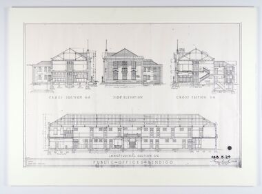
Work on paper - Architectural Drawing, City of Bendigo, Public Offices Bendigo, 23 November 1928
Mounted plan drawings for Public Offices in Bendigo.Cross Section A-A / Side Elevation / Cross Section B-B / Longitudinal Section C-C / R.M.B. / Scale: Eight feet - One Inch / PUBLIC OFFICES BENDIGO ? P.B.B. 5.24 / (signature) / Chief Architect / 23.11.24city of greater bendigo administration item -
 City of Greater Bendigo - Civic Collection
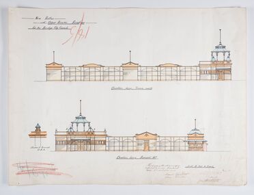
Work on paper - Architectural Drawing, City of Bendigo, New Baths at Upper Reserve Bendigo for the Bendigo City Council, 18th November 1912
The 'New' City of Bendigo baths also known as 'The Baths' were opened on 26th February,1913 at a cost of £2000. These baths made use of an existing dam and had men only and ladies bathing areas as well as a 'paddling paddock' for young children. This set of plans is for the Men's Bathing shed which serviced the men's bathing area adjacent to the still existing tennis courts on Barnard Street. In 1958 the Municipal Baths were replaced by an Olympic Pool and £17,000 was raised by public subscription towards this pool’s construction. Ink, pen, pencil and watercolour architectural drawing for the proposed new baths at the Upper Reserve on Barnard Street, Bendigo.New baths / at Upper Reserve Bendigo / for the Bendigo City Council / Elevation facing tennis courts / Elevation of Terminals at A, A, / Elevation facing Barnard Street / This is one of the drawings /referred to in my contract/ dated 18th November 1912 / Signed Robert J Rogers / (unknown) / Mayor Jas Semmensbendigo swimming club, rosalind park, upper reserve bendigo, faith leech memorial swimming pool, bendigo baths, city of greater bendigo community groups -
 City of Greater Bendigo - Civic Collection
Souvenir - Bendigo Post Office Centenary Ephemera, Ted Rankins, 1987
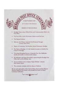
When the Commonwealth Post and Telegraph Act was passed in June 1902, and a national Postmaster General's Department (the PMG) was established the responsibility the nation's mail and telephone services fell on local Post Offices. The Bendigo Post Office was designed by Public Works architect George W Watson and constructed between 1883 and 1887. The two story brick structure with basement has unpainted rendered facades and a 43m high clock tower complete with 6 bell carillon. The facades are elaborately decorated with Corinthian pilasters, balustrading, lions' heads and the state mansard roof with cast iron ridging and finials. (VHR #4739). Situated on Pall Mall it has always been called the Bendigo Post Office even though it was not until 1891 that the name Bendigo was given to the town. The Bendigo Post Office housed much more than just postal services and the building contained many early government departments and services needed for a growing district. The building celebrated its centenary on the 30th September 1987 to much fan fare with Ted Rankins, the then Postal Manager planning many of the week long events including tours of the post office, a grand parade with cake and staff in period costume, a ball at the Shamrock and a barbeque in Rosalind Park. The Post Office ceased providing postal services in 1997 after the privitisation Australia Post and Telstra but continues to play a central role for the community, providing important services to visitors and locals alike. Currently it is occupied by Bendigo Tourism and includes two exhibition spaces including the Living Arts Space and Djaa Djuwima a dedicated and permanent First Nations Gallery. Activities at the Post Office are supported by City of Greater Bendigo staff and a dedicated group of volunteers. These items are part of the postal collection donated by the Rankins family in memory of the last postal manager at the Bendigo Post Office, Ted Rankins. 0364.1: Single sided printed 'Order of Proceedings' flyer; Outlines the running of events for the celebrations on Wednesday 30 September, 1987 at the Post Office with the centenary logo centre top in crimson ink. 0364.2: Single sided, four-colour printed, DL size invitation for celebrations marking the centenary of the Post Office on Wednesday 30 September, 1987. 0364.3,.4,.5,.6,.7: Printed cake bag with centenary logo and image of Bendigo Post Office printed on front in crimson ink. 0364.8,.9,.10,.11: Square note paper with centenary logo and border printed in crimson ink. 0364.12 Envelope: Australia Post envelope with Bendigo 100th anniversary images. Date stamped and addressed to Mr Edmondston Postmaster, Elmore. bendigo post office, bendigo tourism, city of greater bendigo tourism, post office collection, ted rankins collection, city of greater bendigo volunteers -
 City of Greater Bendigo - Civic Collection
Sculpture - Models for public seating for Hargraves Mall, Unknown
Very little is known about the creation of these models other than they were ideas for public seating for the Hargraves Street Mall. Seven small sculptures made of clay and plaster. The two clay models are bisque fired.0419.3 has a '6' written in texta on bottom 0419.7 has a '7' written in texta on bottomcity of greater bendigo public art -
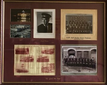 Bendigo Trades Hall Council & Literary Institute Inc.
Memorabilia - Photo Board, The Good Old Days
Large Framed collection of Bendigo Electric Tramways photos with Basil MillerBasil Miller "The Good Old Days" public transport, hat, uniform -
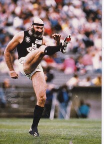 Carlton Football Club
Black & White Photos, Bruce Doull
Photographs of Bruce DoullGroup pf photos of Carlton Player Bruce Doull Career : 1969 - 1986 Debut : Round 5, 1969 vs South Melbourne, aged 18 years, 234 days Carlton Player No. 811 Games : 356 Goals : 22 Last Game : Grand Final, 1986 vs Hawthorn, aged 36 years, 16 days Guernsey Nos. 4 (1969-71) and 11 (1972-86) Height : 185 cm (6 ft. 1 in.) Weight : 87 kg (13 stone, 10 lbs.) DOB : 11 September, 1950 Premiership Player: 1972, 1979, 1981, 1982 Best and Fairest: 1974, 1977, 1980, 1984 Norm Smith Medal 1981 Carlton Hall of Fame (1987) Team of the Century Half Back Flank AFL Team of the Century Half Back Flank Carlton Legend By any measure, Bruce Doull was a champion. One the greatest defenders ever to have played the Australian code of football, he racked up a club record 352 matches for the Navy Blues (including six Grand Finals for four flags) in a 17-year career that stretched from 1969 to 1986. He was Carlton’s Best and Fairest four times, and a member of both the AFL and Carlton’s Team of the Century. It’s a curious fact, however, that we know comparatively little about him. An intensely private person, Bruce shunned publicity and rarely gave interviews. Instead, he let his football do the talking - by taking on and beating the best forwards in the game, week after week. Born Alexander Bruce Doull in Geelong in 1950, he was recruited by Carlton’s Under-19 squad in 1968 from the Jacana Football Club in Melbourne’s northern suburbs. In those early days he was a ruck-rover or half-forward, with a conservative haircut and a burning ambition to be a League footballer. The Blues were the reigning premiers, and the club’s roster was rich in talent across all three grades. Even so, Bruce played only a handful of games with the Under-19 squad (in guernsey number 53) before he was promoted to the Reserves and allocated the highly-prestigious number 4. Then, in only his second season at Princes Park, the shy youngster was selected to make his senior debut for Carlton in a home-ground match against South Melbourne in round 5, 1969. He sat on the reserves bench throughout the first half that afternoon, before being called on to replace the injured Alex Jesaulenko at half-time. Once on the field, Bruce made the occasion even more memorable by kicking his first career goal early in the third quarter, and Carlton held off the fast-finishing Swans to win by 25 points. Throughout 1969-70, Doull played another 14 matches as a winger, ruck-rover or half-forward. He was overlooked for a finals berth in both seasons, but mid-way through 1971, senior coach Ron Barassi told him that there was a regular spot available in defence if he wanted it bad enough, which Bruce certainly did. Given an opportunity to impress at half-back, his judgement, deceptive pace and strength in the air stood out, as did his remarkable poise and calmness under pressure. At 185 cm and 87 kg, Doull was no giant. Yet he soon demonstrated a remarkable ability to "play tall" in a key defensive role. And when the ball came to ground, he stayed in the contest because he never lost his concentration. His all-round agility was exceptional - making him equally as effective in a pocket or on a flank - and physical pressure rarely unsettled him.show_image.php?id=34774 In his 53rd senior appearance for Carlton - the 1972 VFL Grand Final - Doull stamped himself as a rising League star by subduing Richmond’s champion centre half-forward Royce Hart on the biggest stage of all. The Tigers kicked a huge 22.18 that afternoon, but Carlton booted 28.9 in the highest aggregate decider ever played, and collected an eleventh VFL Premiership. Hart was kept to just a handful of possessions and two goals for the match, so the media was soon clamouring for information about the Tiger star’s conqueror. Bruce complied, but he was uneasy in the spotlight and from then on was rarely available. At the same time, Doull had become the latest folk hero at Princes Park. Supporters loved his no-nonsense approach, his courage and his consistency. In keeping with his shy nature is the story of his playing numbers. More and more during his first three seasons in number 4, he was uncomfortable in the locker room because of the attention that was focused on him, in the presence of some of the club’s modern greats like Serge Silvagni (number 1), John Nicholls (2), Kevin Hall (3), Syd Jackson (5) and Garry Crane (6). Therefore, at the conclusion of the 1971 season he was granted a request to switch to guernsey number 11, which had become available due to the retirement of another idolised Carlton defender in John “Ragsy” Goold. With his new number, Bruce shifted only a few metres down the line of lockers, but for him, anywhere further from the limelight was appreciated. By his mid-twenties, Doull was sporting lavish sideboards and hair to his shoulders, which contrasted somewhat with his shy nature, and made him hard to mistake on the field. He won Carlton's Best and Fairest award in 1974, and followed up again in 1977, 1980 and 1984. In 1979 he collected his second Premiership medal when the Navy Blues knocked over Collingwood in a hard-fought, controversial Grand Final remembered for Wayne Harmes’ brilliant solo effort to seal the match. Two years later, Bruce’s finest hour arrived when the Blueboys broke myriads of Magpie hearts again to win the 1981 Grand Final by 20 points. Impassable all day at centre half-back, Doull beat four opponents, and was a worthy winner of the Norm Smith medal as Best on Ground. Twelve months on from that triumph, Bruce collected his fourth Premiership medal when the wounded Blues upset their other traditional rival, Richmond, for the '82 flag. By then nicknamed the “Flying Doormat” by TV commentator Lou Richards - in deference to his balding pate, shaggy beard and hair, kept under control by a navy blue or white headband - Doull led a Carlton defence that was rock-solid in the Blues' 18 point win. Although he would not have been overly concerned, plenty of good judges were gobsmacked afterwards when Bruce missed out on his second Norm Smith medal, which went instead to Richmond's Maurice Rioli. From 1976 to 1981, Bruce was a fixture in the Victorian State team, and earned a recall in 1984 at the age of 33. He was a remarkably durable and suffered a debilitating injury only once in his career, in 1985 – shortly after he had set a new games record at Carlton of 329 matches to succeed John Nicholls. He wrenched a knee at training a few days later, and ended up playing only three senior games for the season. Eventually, Doull made 356 appearances for Carlton, including 162 in succession to set another club record. He was never reported by the umpires for foul play, and widely respected for his fairness in playing the ball rather than the man. A former team-mate, Brent Crosswell once wrote: "Doull's game has a moral purity about it, and that is why opponents have always found it extremely difficult to be unfair to him. It would have shamed them." Carlton Coach of the Century David Parkin was equally as complimentary when he described Bruce as “the best team player I ever coached.” Doull’s final game for Carlton came in the sixth Grand Final of his career, when Hawthorn demolished the Blues in a one-sided 1986 decider. Star Hawks full-forward Jason Dunstall kicked six goals on the 36 year-old veteran in that match, but in the context of Bruce’s career as a whole, it was barely a blemish. He may have been a shy and reserved individual in public, but when Bruce Doull pulled on the famous Old Dark Navy Blue, he became one of the true legends of VFL/AFL football. Just one year after his retirement, Bruce was elected to the Carlton Hall of Fame. In September 1996 he was named on a half-back flank in the AFL Team of the 20th Century, and in 2000 filled the same spot in Carlton's Team of the Century. Then, in June 2014, during celebrations marking Carlton's 150th year of VFL/AFL competition, Bruce was named as one of the five greatest Blues of all time, alongside John Nicholls, Stephen Kernahan, Alex Jesaulenko and Stephen Silvagni. Footnotes On the way to victory in the 1982 Grand Final against Richmond, Doull was involved in a celebrated incident that stopped the game and both amused and infuriated the 107,536 fans at the ground. During a tense third quarter, Carlton was in front by one point when a naked female dashed out into the middle of the MCG. Wearing nothing but a Blues scarf, 18 year-old Helen D’Amico made a bee-line for Doull, and tried to embrace him before she was intercepted by his team-mate Wayne Johnston and disturbed match officials. With the crowd in uproar, she was bundled into an over-sized cardigan and marched off the ground, as Carlton went on to upset the Tigers by 18 points. It later emerged that Ms D’Amico had been working as a strip-tease artist at an Adelaide nightclub, and her streak was a publicity stunt. Milestones 50 Games: Semi Final, 1972 vs Richmond 100 Games: Round 22, 1974 vs St Kilda 150 Games: Round 3, 1977 vs St Kilda 200 Games: Round 14, 1979 vs Fitzroy 250 Games: Round 18, 1981 vs Geelong 300 Games: Round 19, 1983 vs St Kilda 350 Games: Round 19, 1986 vs Collingwood Career Highlights 1972 - 5th Best & Fairest 1972 - Premiership Player 1973 - 8th Best & Fairest 1974 - Robert Reynolds Memorial Trophy - Best & Fairest Award 1975 - Arthur Reyment Memorial Trophy - 2nd Best & Fairest 1976 - Arthur Reyment Memorial Trophy - 2nd Best & Fairest 1977 - Robert Reynolds Memorial Trophy - Best & Fairest Award 1979 - 7th Best & Fairest 1979 - Premiership Player 1980 - Robert Reynolds Memorial Trophy - Best & Fairest Award 1981 - 4th Best & Fairest 1981 - Norm Smith Medal 1981 - Premiership Player 1982 - 5th Best & Fairest 1982 - Premiership Player 1983 - 2nd Best & Fairest 1984 - Robert Reynolds Memorial Trophy - Best & Fairest Award 1984 - Best Clubman Award Links Articles: Bruce Doull Speaks | Yesowooloonko - You Beauty! | Moving Guernsey Numbers - UP! | Carlton's Magnificent Seven Footage Interview after the 1981 Grand Final: https://www.youtube.com/watch?v=uzAqqk2u6y0 Toyota Bruce Doull Advertisement: https://www.youtube.com/watch?v=Zk_yu4t8vYQ Driving with Sam Pang: https://www.youtube.com/watch?v=WNwUaqVYBDo Bruce Doull vs Glenn Archer: https://www.youtube.com/watch?v=yVmHGMLFVqg Blueseum: Playing Career of Bruce Doull | Carlton Legends | Career Breakdown | Doull's Blueseum Image Gallery Video 1972 1973 1976 1977-79 1980 1981 1982 1983 1984 1985 InterviewBlack & White photos -
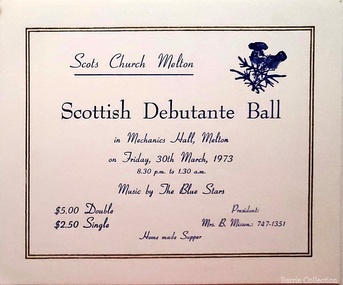 Melton City Libraries
Card, Scottish Debutante Ball invite, 1973
"The Mechanics’ Institute hall (demolished) and the library played a central role in the story of Melton social life, and in the development of its learning, culture, entertainment, celebration, commemoration and many community groups. The building on the site today - with the Court House the only remaining early community or public building remaining in High Street - is a tribute to the energy and talents of the very small Melton community over many years. Its substantial size, brick materials, and the evident use of an architect in its design, sets it apart from most other simple weatherboard Mechanics’ Institutes that were built in smaller country towns in Victoria. The financing and upkeep of this building, which was community-owned until 1982, and built on land purchased by the community rather than granted by Government, itself contributed to the coming together of the Melton community in decision making and fundraising. Although the original hall is demolished, the 1983 Melton Community Hall adjacent is partly its successor, demolition of the Institute hall having been predicated on its construction. The surviving brick front portion of the Institute was opened by the Hon. J Murray, Premier of Victoria in 1910". Scottish Debutante Ball hosted by Scots Church Melton at the Mechanics Hallchurches -
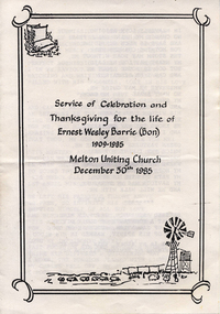 Melton City Libraries
Document, Service of Celebration and Thanksgiving for the life of Ernest Wesley Barrie (Bon) 1909-1985, 1985
SUMMARY - Ernest W (Bon) Barrie, 1909 – 1985 Profile Melton Mechanics Institute Member 1935 - 1982i Trustee 1952 - 1982 Life Member 1968 Years of service – 47 years He constructed and provided a public address system which was used at Melton and district halls and sports grounds for a wide variety of community events including school sports, gymkhanas, theatrical productions and processions. Fire Brigade Melton Fire Brigade (and predecessor Bush Fire Brigade) Apparatus Officer, 1945 - 1953 Captain, 1951 - 1965 Mt Cotterill Fire Brigades’ Group Elected Group Officer, on the formation of the Group, 1967. As Group Communications Officer he operated the VL3 LY base radio station from home on a 24 hour basis for fire brigades of Melton, Rockbank, Sydenham, Diggers Rest, Toolern Vale, Truganina and Werribee. With his brother Edgar, he built the first Melton Fire Truck. It was housed on the family property until a fire station was constructed in the Melton township. Recipient of the Queens Medal, 1979 Recognised for 44 years of service on the Melton Fire Brigade Memorial Wall Plaque, dedicated May 2013 Melton State School, no 430 Committee – School Correspondent (secretarial and financial role) 34 years of Service Provided his Amplifier Equipment for events and the annual district School Sports from 1939-1973. Donated the House Athletic Shield Melton and District Historical Society 1968 – 1985 President and foundation member Willows Historical Park – supported the establishment of the park and contributed many volunteers hours in the construction and landscaping of the precinct Member, Western Metropolitan Groups of Historical Societies, 1980s Shire of Melton Councillor South Riding, 1969-1971 Member of the Water Trust Melton Uniting Church Melton Uniting Church (and its predecessors the Methodist, Methodist-Presbyterian churches). A lifetime association which extended from childhood when he attended Sunday school until his death in 1985. Member of the Presbyterian Board of Management for more than 25 years in which he held positions of Honorary Secretary and Treasurer, Board member of the Parish Council and Member of the Committee of Management. He was a Sunday school teacher 1933. Community development With Mr RC Butler met with Shire Council in 1937 to canvass residents to ascertain prospective Electric consumers in the district. Electricity was subsequently turned on at dusk on 20th December 1939. Melton Progress Association, including Melton Musical, Elocutionary and Vocal Competitions, Vice President 1939 1940 Melton Development Association, 1960s Volunteer Air Observers Corps (VAOC)ii Carried out plane spotting at Shire Office and spotting tower in Melton and later from home until 1944/45. Agriculture and farming Progress and Better Farming Association, Melton. Honorary Secretary, 1935 Member, Agricultural Engineering Society Australia c1960-1985 A successful grower of wheat, oats and barley, he planted experiment plots and held Field Days on the “Darlingsford” property. He later diversified into other grains and sheep (wool and meat). He took a enthusiastic interest in agricultural engineering and was keen to introduce innovative ideas that improved the productivity of farms and farming practices. In the mid 1950 he conducted trials during harvest on the family property of the original mechanical hay fork built on a British Bedford truck by Bill Gillespie. This design was further refined in collaboration with the Gillespie brothers and resulted in the construction the hydraulically operated tractor mounted hay fork. The innovative design of the hay fork created interest from far and wide and was quickly taken up by farmers because it significantly reduced hand labouring of loading sheaves of hay with a pitch fork. His father established chaff mills in Melton, Rockbank, Parwan, Diggers Rest in the first decade of 1900 and in 1915 went into partnership with JR Schutt to establish the Schutt & Barrie Pty. Ltd. Chaff Cutting and Flour Mill in West Footscray. When it ceased trading in 1968 the directors were: Ernest W Barrie and Thomas L Barrie, R, A, and M Schutt. Awards Queens Medal, 1979 Rotary Award for Community Service, 1980 Victoria 150th Anniversary Celebrations contributions, 1985 Service held at Melton Uniting Church local identities -
 Melton City Libraries
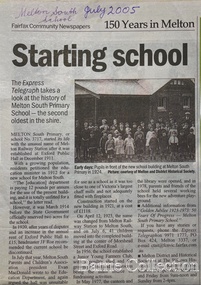
Newspaper, Melton Schools-150 years in Melton, 2005
Melton South "The establishment of a settlement of Melton South was induced by the opening of the railway in 1884. This subsequently prompted a number of industries, initially sawmills, and in the early twentieth century, chaff mills. This development coincided with the Exford ‘Closer Settlement’ estate at the beginning of the new century, boosting local population and produce, and the development of the chaff industry which employed many people in the Melton area. (Around 1912 the government had brought out English migrants to settle the Exford estate.) By c.1912 the small Melton Railway Station settlement had a boarding house (probably for chaff or sawmill employees), store, a small church and a hall. The Melton Valley Golf Club originated near the railway station in 1927 (in 1931 it moved to the present Melton links). In 1910 the community had built the large timber ‘Victoria Hall’, which became the focus of community life for several generations. In August of that same year AR Robertson MP and D McDonald applied for the establishment of a school on land set aside for that purpose by the Closer Settlement Board, near the Melton Railway Station settlement. District Inspector McRae recommended that a school for classes up to Grade 3 be established as an adjunct to the Melton State School. And so SS3717, ‘Melton Railway School’, was established in the leased Victoria Hall on 1st December 1911. Thomas Lang, head master at Melton since 1896, was in charge of both schools. As a ‘prep’ school only, it was necessary that the older Melton Railway Station settlement students travel to Melton SS430 at Unitt Street. Since 1912 local residents had been petitioning for the establishment of a separate school at Melton Railway Station on the grounds that it would be better if all children from the one home could attend the same school, and that the Victoria Hall was unsuitable as a school building. As a result an area of 2 acres - Allotment 8, Parish of Djerriwarrh, Exford Estate - was reserved for a State School on 4th March 1914. However the Department wrote that a school would not be established there in the near future, as ‘there is no likelihood in sight that the Railway Station settlement will increase in importance’. Parents persisted with their petitions to the Education Department, claiming that the Victoria Hall was too large, had no fireplace, that teachers were unable to use the wall for teaching aids, and that, being less than 20 metres away from a chaff mill employing 30 men, was too noisy. The turning point came when in 1920 the Hall Committee decided to increase its rent for the hall. In 1920 Head Teacher Lang advised the Education Department to discontinue SS3717 as an adjunct. The District Inspector supported this recommendation, and the schools separated in 1923. In April of that year 41 children, comprising Grades 1-8, moved into an almost completed brick building on the present site. On the 6th July 1923 the official opening of the school took place; after a ceremonial journey from the Hall to the school, speeches were given by the Hon AR Robertson and the Chief Inspector of Education. Everyone then journeyed back to Victoria Hall for a ‘bountiful repast’. (These dates are at odds with the date of 5th March 1925 given in Blake as the date the children occupied the new SS3717 brick school building. ) A teacher’s residence had been purchased for ₤500 in 1923, and the school’s name was changed to ‘Melton South’ in the same year. Even though the older Melton South pupils would no longer have to travel to the Unitt Street school, an additional brick room was still required at the Melton SS430 in that same year. In 1961 a new room was added to the school. In 1972, at the beginning of Melton’s boom as a satellite town, the number of enrolments was 224. The school has since shared in the exponential growth of the town of Melton, and at the time of its jubilee celebration (1983), 524 pupils were enrolled. Victoria Hall, neglected and vandalised, was demolished in 1992. It had been handed back to the Council on condition that it be replaced by a new hall, with the same name, and was commemorated by a plaque. Apart from the 1923 brick school building, and the railway station, none of the principal early Melton South public sites survive. Few early residential sites remain. (Further research will establish whether the house on the corner of Station Street and the railway line was the original teacher’s residence.)" Melton State School "On 17th May 1858 a State subsidised, combined Denominational School was opened by HT Stokes, with an attendance of about 30 children. This school was conducted in the wooden Melton Combined Protestant Church, situated on ‘a creek flat’ thought to be on the north side of Sherwin Street between Pyke and Byran Streets. It is likely that the Church had been established by 1855 and that the first minister was the Rev. Hampshire, who lived in Cambridge House on the Exford Estate. Ministers of the Protestant denominations were invited to hold services there. As there was only one resident Minister in the town (Presbyterian Mr J Lambie), laymen of the various denominations often spoke on Sundays. In 1863 this building was declared a Common School with the number 430. One of its first and most prominent headmasters was John Corr, who served from 1860 to 1864. Most of Mr Corr’s children also became teachers, including Joseph Corr, at the Rockbank school, and J Reford Corr and WS Corr, headmasters and teachers at numerous prestigious private secondary schools around Australia. John Corr purchased land alongside the school and elsewhere in and near Melton, became secretary and treasurer of the new Cemetery Trust, and by July 1861 was deputy registrar of births, deaths and marriages. He walked three miles every Sunday to teach at the Weslyan Sunday School he had established. Despite good reports from the Education Department Inspector, and burgeoning enrolments, the local school committee recommended the dismissal of, firstly, his wife (from the work mistress position), and then him from the headmaster position. Corr saw his dismissal as an attempt to redirect state aid for education from the Combined Protestant school to the support of the Free Presbyterian Minister Rev James Lambie (by one account the owner of the land on which the Common School was erected), whose son-in-law James Scott subsequently assumed responsibility for the school. Rev Lambie failed in his efforts to keep the existing school, which the Education Department Inspector and the majority of Melton citizens regarded as badly situated and badly built. Following a conditional promise of state aid, local contributors in 1868-69 raised ₤72.10.6 towards the cost of an iron-roofed bluestone rubble building 43 ft x 12 ft. This was erected on a new site of 1.5 acres (the present site). The State contributed ₤120 to the new school, which opened in 1870. A very early (c.1874) photograph of the school shows its headmaster and work mistress / assistant teacher (probably James Scott and his wife Jessie) and its (very young) scholars. Similar photos show pupils in front of the school in c.1903, and 1933. In 1877 a second bluestone room costing ₤297 was added and further land acquired from the Agricultural Society (who only needed it two days a year) to enlarge the schoolground to 3 acres. In the early 1880s an underground tank augmented the school water supply and in 1919 a five-roomed wooden residence was added. During this period the school correspondents often compained that the walls of the bluestone buildings were damp, affecting the plaster. In 1923 a brick room 26 ft 6 in by 24 ft with a fireplace and four rooms facing south, was added, and a corridor built to link the three buildings. This served adequately for the next 40 years. The school bell probably dates to 1883. The school also has a memorial gate (1951) to World War One ex-students, and an honour board to the 64 ex-students who served in the First World War. The school roll fell to 42 in the early post war-years, but was boosted by an influx of migrants, mainly from the UK, from the late 1960s. This presaged the boom in Melton’s development, and the corresponding growth of the school, with timber and temporary classrooms added to the previous masonry ones. An endowment pine plantation established in 1930 augmented the school’s fundraising activities when it was harvested in 1968. Part of the site was planted with eucalyptus trees in 1959. Famous ex-students of the early twentieth century included Hector Fraser (internationally successful shooter) and cyclist Sir Hubert Opperman". The Express Telegraph articles about the history of Melton South and Melton State Schoolseducation -
 Melton City Libraries
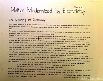
Newspaper, Melton Modernised by Electricity, 1939
Electricity – 1939 eeb Express Dec 9th 1937 Electric Light Petition First combined (schools) sports meeting, Melton south, Rockbank, Mt Cotterell, Toolern Vale, Sydenham West, Melton Park, Exford. Jack Wallace Starter, G Wilson (ref) G McDonald, F Ryan judges. A G Macdonald Gate Keeper, A Bamford, E W Barrie, S Rogers Announcers. M P A call meeting for 24th March Two or three progressive residence of Melton township are still pushing quietly for a water scheme for Melton and extension of electricity service expected to be provided for the beam wireless station a Rockbank. One of these has gone so far as to seek opinion of an independent engineer regarding the possibility of township water supply. May 1 1937 A move to combine in Melton Shire Council to convene a public meeting to agitiate for extension of the Electric Supply to Melton is being undertaken by the Progress Association and the Hall Committee. Melton Progress Association and Melton Mechanics Institute Committee joined in a decision to request Melton Shire Council to call a Public Meeting to push for extension of Yallourn electricity to Rockbank and Melton June 12th July 3rd Residents of Melton and Rockbank have an opportunity to reveal attitude towards proposed extension a result of MSC in convincing a public meeting MMI support from Amalgamated Wireless A/Asia Ltd directors Mr Townsing to preside which had been convened by MPAssoc and MMI nicely timed as SEC estimates for ensuing year known to be in course of preperation. Saturday 17th July 1937 Melton Move for Electricity. Meeting shows ….. extensive article …. meetin appointed Messrs Butler and Barrie canvass the town Dec 9th 1939 Mechanics Institute floor to be prepared next week Electricity installed in Melton, article featured in the Melton Expresslocal significant events -
 Tarnagulla History Archive
Research file: Transcriptions of historic news content relating to Ironbark Reef
... Tarnagulla History Archive Tarnagulla Public Hall 69-71 ...David Gordon Collection. File compiled by David Gordon. -
Tarnagulla History Archive
Research file: Transcriptions of historic news content relating to Havelock Reef
... Tarnagulla History Archive Tarnagulla Public Hall 69-71 ...David Gordon Collection. File compiled by David Gordon. -
Tarnagulla History Archive
Research file: Transcriptions of historic news content relating to Greek's Hill Reef
... Tarnagulla History Archive Tarnagulla Public Hall 69-71 ...David Gordon Collection. File compiled by David Gordon. -
Tarnagulla History Archive
Research file: Photocopies of historic documents relating to New Yorkshire Mining Co
... Tarnagulla History Archive Tarnagulla Public Hall 69-71 ...David Gordon Collection. File compiled by David Gordon. -
Tarnagulla History Archive
Research file: Photocopies of financial records relating to New Yorkshire Mining Co
... Tarnagulla History Archive Tarnagulla Public Hall 69-71 ...David Gordon Collection. File compiled by David Gordon. Copied from records held at PROV.. -
Tarnagulla History Archive
Photocopy of prospectus: Yorkshire Gold Mine Tarnagulla
... Tarnagulla History Archive Tarnagulla Public Hall 69-71 ...David Gordon Collection. Compiled by David Gordon. Housed in plastic display folder -
Tarnagulla History Archive
Issue of Newsrail magazine: Article about train derailment at Tarnagulla, 2018
... Tarnagulla History Archive Tarnagulla Public Hall 69-71 ...David Gordon Collection. Article on p332railways, transport, disasters, accidents -
Tarnagulla History Archive
Book: Notably Newbridge & Poseidon pre 1925 by Ken Arnold, 2014
... Tarnagulla History Archive Tarnagulla Public Hall 69-71 ...David Gordon Collection. -
Tarnagulla History Archive
Book: The Akers & Joy Families, 2005
... Tarnagulla History Archive Tarnagulla Public Hall 69-71 ...David Gordon Collection. by Des Akers -
Tarnagulla History Archive
Book: Dunolly, A School On The Rise, 2006
... Tarnagulla History Archive Tarnagulla Public Hall 69-71 ...David Gordon Collection. by Bill Humphreys -
Tarnagulla History Archive
Book facsimile: A Gold Digger's Diaries by E.F. Peters, Copy of diaries written 1851-1857
... Tarnagulla History Archive Tarnagulla Public Hall 69-71 ...David Gordon Collection. Complete photocopy of original book, bound as book. -
Tarnagulla History Archive
Book: From Ireland to Oz, 2015
... Tarnagulla History Archive Tarnagulla Public Hall 69-71 ...David Gordon Collection. by Mary Blanchard Balle. About Catherine Mary Kirwan who married publican William Stubbs (Rising Sun Hotel). Both lived in Tarnagulla with Stubbs children during gold rush. -
Tarnagulla History Archive
Book: A Gold Digger's Diaries by Ned Peters, published 1981, original diaries 1851-1857
... Tarnagulla History Archive Tarnagulla Public Hall 69-71 ...David Gordon Collection. edited by Les Blake. Hardcover. -
 Tarnagulla History Archive
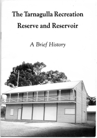
Booklet: The Tarnagulla Recreation Reserve and Reservoir, A Brief History, 1990
... Tarnagulla History Archive Tarnagulla Public Hall 69-71 ...David Gordon Collection. Compiled by the Committee of Management of the Tarnagulla Recreation Parks in 1990. -
 Tarnagulla History Archive
Booklet: The Tarnagulla Recreation Reserve and Reservoir, A Brief History, 1990
... Tarnagulla History Archive Tarnagulla Public Hall 69-71 ...David Gordon Collection. Compiled by the Committee of Management of the Tarnagulla Recreation Parks in 1990. -
Tarnagulla History Archive
Booklet: Tarnagulla - A History, 1985
... Tarnagulla History Archive Tarnagulla Public Hall 69-71 ...David Gordon Collection. Published by Tarnagulla Hall Committee in 1985. -
Tarnagulla History Archive
Booklet: Tarnagulla Urban Fire Brigade, 125 Years of Service to the Community, 1994
... Tarnagulla History Archive Tarnagulla Public Hall 69-71 ...David Gordon Collection. -
Tarnagulla History Archive
Book: Addresses To HRH The Duke of Cornwall, 1901
... Tarnagulla History Archive Tarnagulla Public Hall 69-71 ...David Gordon Collection. Full title: Addresses To HRH The Duke of Cornwall & York, His Excellency the Governor General, The Earl of Hopetoun, From the Municipalities of Victoria Address from Borough of Tarnagulla on bookmarked page. -
Tarnagulla History Archive
Annual Report for the Secretary of Mines and Water Supply (1903)
... Tarnagulla History Archive Tarnagulla Public Hall 69-71 ...David Gordon Collection.