Showing 20688 items matching "time-allotment"
-
![Map, Millbank Estate Bacchus Marsh Thursday 4th October 1888 [Land sales], 1924](/media/collectors/5e461d8021ea67224c82f2a1/items/67765662eb6d2cbd24e0797f/item-media/67765682eb6d2cbd24e07a41/item-fit-380x285.jpg) Bacchus Marsh & District Historical Society
Bacchus Marsh & District Historical SocietyMap, Millbank Estate Bacchus Marsh Thursday 4th October 1888 [Land sales], 1924
The Millbank Estate was a parcel of land close to the centre of the shopping area of Bacchus Marsh which was sub-divided and offered for sale in 62? lots on the 4th October 1888. The lots had frontages to Ballarat Road (Main Street), Maddingley Road (now Grant Street), Turner Street, Millbank Street, Clarinda Road (now Clarinda Street), and an unnamed street south of Turner Street (possibly known as Grant Street at this time) which connected to Maddingley Road through the vicinity of the present day Bacchus Marsh Hospital. This was a significant sub-division of land and represented a major expansion of residential housing in Bacchus Marsh in the late 19th century. The map includes a wealth of detail about the time of the sale, where it will take place, who the selling agents were, the deposit terms for purchases and details of a special train from Melbourne to Bacchus Marsh on sale day. The location of the allotments in relation to the shopping and commercial area of Bacchus Marsh, Maddingley and the railway station are indicated on an inset map within the overall map and poster. The Millbank Estate area was an area which had once belonged to the Grant family who were prominent early citizens of Bacchus Marsh and lived in a house in this area known as 'Millbank'.This land sale map is a typical example of housing estate land sales advertising maps produced by real estate agents in this era. The map is significant for the detailed information it provides about when and where land was sold for new housing estates in Bacchus Marsh in the late nineteenth century.Single page map showing land allotments for sale at auction in Bacchus Marsh in October 1888. A significant portion of the map is missing from the bottom right side. land sales bacchus marsh, land subdivsion bacchus marsh, housing estates land sales bacchus marsh, grant family bacchus marsh, millbank estate land sales -
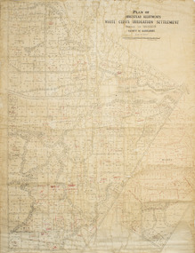 Merbein District Historical Society
Plan - Plan, Allotments, Plan of Homestead Allotments White Cliffs Irrigation Settlement Parish of Merbein County of Karkarooc
Large plan drawn in black ink on cream colour paper with linen backing. Some red ink addedWritten in red pen new owners of allotmentsallotments, merbein, irrigation, whitecliffs, county of karkarooc -
 Clunes Museum
Ephemera - TICKET, 1977
TICKET WAS FOR AN OLD TIME BALL ON FRIDAY 2ND SEPTEMBER, 1977 AS PART OF THE JAMES ESMOND FESTIVALTICKET FOR OLD TIME BALLlocal history, documents, tickets, events and celebrations, james esmond festival -
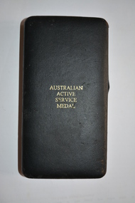 Wangaratta RSL Sub Branch
Medal - Medals, minature
Two minature medals are:- The International Force East Timor (INTERFET) Medal recognises members of the Australian Defence Force who served for 30 days in East Timor during the INTERFET campaign (16 September 1999 – 10 April 2000). Australian Active Service Medal with 'East Timor' clasp.The Australian Active Service Medal (AASM) is an Australian military decoration. It was authorised on 13 September 1988 to recognise prescribed service in "warlike" operations, backdated to February 1975. It is awarded with a clasp to denote the prescribed operation and subsequent awards of the medal are made in the form of additional clasps.Presentation box containing two circular silver metal medals attached to striped ribbons mounted together with pin attached at rear.Presentation box lid - Australian Active Service Medal Medal -East Timor Medal - International Force East Timormedals, east timor, interfet -
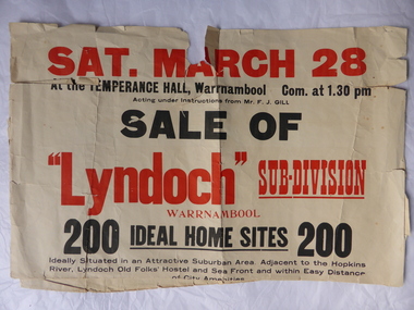 Warrnambool and District Historical Society Inc.
Poster, Lyndoch Sub-Division
This is a poster advertising the sale of the Lyndoch sub-division in Warrnambool with the sale of 200 housing sites. The sale took place about 1958 with the land sold by Frederick Gill, a Warrnambool jeweller. The land was previously owned by George Rolfe who had acquired the land near the mouth of the Hopkins River in the 1880s and named the property ‘Lyndoch’. He bought the surrounding land at a later time. This sub-division came to be known as the Gill Estate. It was a valuable site as many of the allotments fronted the sea and others were adjacent to the Hopkins River. This poster, although tattered, is of interest as it has many details of the Gill Estate sub-division and will be useful to researchers. This is a cream-coloured paper poster with black and red printing. The poster has a small map in a circle shape showing the location of the streets and a larger map section showing the streets and the allotments to be sold. The poster is in two pieces and the edges are torn and, in some sections, missing. The streets map has some pencil annotations. history of warrnambool, lyndoch, warrnambool, george rolfe, frederick gill -
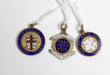 Warrnambool and District Historical Society Inc.
Medal - Cycling Medals W. S. Toyne
These cycling medals were awarded to W. S. Toyne. Two of these medals are time medallions relating to the Warrnambool to Melbourne Cycle Race. This race was first held in 1895 and continues to the present day. It was originally a handicap race from Warrnambool to Melbourne but after 1938 it became a Melbourne to Warrnambool race. After 1995 it became a scratch race and today the distance is shorter with the race starting from Avalon. It is the second oldest one-day cycling race in the world and the longest one-day cycling race in Australia. All riders who complete the race in a given time are awarded a Time Medallion. The race was sponsored by the Dunlop company from 1901 to 1927. In 1923, 123 of the 196 riders, who started at 5:30am completed the 165 mile road race and were awarded the time medallion. W. S. Toyne was listed among the some of the first cyclists to go through Camperdown at 8:16am. It was reported that over 50,000 spectators witnessed the progress of the race. These cycling medals belonged to a cyclist, W. S. Toyne, who completed in a significant sporting event in Warrnambool in 1923 and 1924. [.1] Round metal and enamel medal with blue enamel edge and an unidentified white coat of arms with a red cross containing five stars on the obverse side. The shield is held by an embossed kangaroo on the left and an emu on the right. The reverse is inscribed with name and time in an inner circle and the year and race on the outer edge. [.2] Round metal and enamel medal with blue enamel edge and a white enamel shield containing five stars in the centre of the obverse side. The reverse is inscribed with the name and time in the inner circle and the race name on the outer edge. [.3] metal and enamel medal with a blue enamel circle with white enamel boomerangs sitting above and below.[.1] Obverse: Dunlop Road Race; Reverse: Warrnambool-Melbourne Time Medallion 1924 Won by W. S. Toyne 5 Hrs. 47 Mns. 42 Sds. [.2] Obverse: Dunlop Road Race 1923; Reverse: Warrnambool-Melbourne Time Medallion; Won by W. S. TOYNE 10 Hrs. 30 Mns. Sds. [.3] Obverse: Barnet Glass Ballarat-Melbourne Road Race 1923; Reverse W. S. Toynew. s. toyne, dunlop road race, barnet glass road race, ballarat to melbourne cycle race, time medallions, warrnambool to melbourne cycle race -
Clunes Museum
Functional object - TIME CLOCK, International Business Machines Pty. Ltd, 1924
THIS TIME CLOCK WAS USED IN THE INTERKNIT HOSIERY CO. KNITTING MILL FROM 1946 - 1977 TO RECORD EMPLOYEES TIME SHEET WHICH IS PLACED IN THE GLASS FRONTED CUPBOARD BEHIND BEHIND AND WHEEL.BROWN VARNISHED CUPBOARD WITH TIME CLOCK ON FRONT. A LEVER WITH PUNCH LIKE DEVICE TO RECORD TIME OF ARRIVAL AND DEPARTURE OF EMPLOYEES. A DOUBLE ROW OF HOLES ROUND THE EDGE OF A WHEEL NUMBERED 1 - 100, BEING EMPLOYEES NUMBERS. INTERNATIONAL TIME RECORDING CLOCK.local history, horology, chronometers, knitting mill interknit hosiery co. -
Clunes Museum
Map, DEPARTMENT OF LANDS AND SURVEY
MAP OF ALLOTMENTS IN CLUNESlocal history, documents, map, township, clunes -
 City of Moorabbin Historical Society (Operating the Box Cottage Museum)
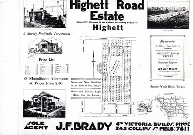
Flyer - Highett Road Estate, Highett
With the growth of Melbourne the market gardens were subdivided into building blocks as the land was worth more than the value of the crops.Example of the progress of the Municipality of MoorabbinPhotocopy of advertisement of private sale of housing lots in Highett.Highett Road Estate, Highett - 85 Magnificent Allotmentshighett road, wilson st, dalmont street, highett, real estate -
 Queenscliffe Maritime Museum
Functional object - Door and Locker
Obtained form the wreck of the Time on Corsair Rock and was collected by Norman Hunt who was a lighthouse keeper at Point Lonsdale. Door and Locker from the wreck of the Timeships fittings, lighthouse keeper, norman hunt, point lonsdale lighthouse -
 National Vietnam Veterans Museum (NVVM)
Memorabilia - Belt buckle, US
Oval shaped metal buckle with Vietnam (top) Veteran (bottom) in Silver on Black enamel. 1959-1975. Red center with red, white and blue shield in middle of Eagle in flight. "I served my time in hell" engraved on bottomI served my time in hell engraved on bottom. 2278 on reverse of bucklebelt buckle, vietnam veterans -
![Monnington [Estate], 1935](/media/collectors/550653872162f11fb04854aa/items/5907eb86d0ce0c14e82385c8/item-media/5907ecafd0ce0c14e823e87f/item-fit-380x285.jpg) Kew Historical Society Inc
Kew Historical Society IncPlan - Subdivision Plan, Monnington [Estate], 1935, 1935
Pru Sanderson, in her groundbreaking ‘City of Kew Urban Conservation Study : Volume 2 - Development History’ (1988), summarised the periods of urban development and subdivisions of land in Kew. The periods that she identified included 1845-1880, 1880-1893, 1893-1921, 1921-1933, 1933-1943, and Post-War Development. These periods were selected as they represented periods of rapid growth or decline in urban development. An obvious starting point for Sanderson’s groupings involved population growth and the associated economic cycles. These cycles also highlighted urban expansion onto land that was predominantly rural, although in other cases it represented the decline and breakup of large estates. A number of the plans in the Kew Historical Society’s collection can also be found in other collections, such as those of the State Library of Victoria and the Boroondara Library Service. A number are however unique to the collection.Subdivision plans are historically important documents used as evidence of the growth of suburbs in Australia. They frequently provide information about when the land was sold on which a built structure was subsequently constructed as well as evidence relating to surveyors and real estate and financial agents. The numerous subdivision plans in the Kew Historical Society's collection represent working documents, ranging from the initial sketches made in planning a subdivision to printed plans on which auctioneers or agents listed the prices for which individual lots were sold. In a number of cases, the reverse of a subdivision plan in the collection includes a photograph of a house that was also for sale by the agent. These photographs provide significant heritage information relating house design and decoration, fencing and household gardens.The first subdivision of Monnington took place in 1935. At that time, Monnington and 10 new allotments were offered for sale bordering Adeney and Marshall Avenues. In this subdivision plan, Monnington is one of 13 lots for sale. The subdivision created the irregular land holding of Monnington today. The excision of southwest corner of Monninton was caused by the need to have regular allotments facing the curve in Marshall Avenue.monnington - adeney avenue -- kew (vic.), subdivision plans -- kew (vic.) -
 City of Moorabbin Historical Society (Operating the Box Cottage Museum)
Functional object - Punch Clock, manual, circa 1880
The large, early, manual, ‘Punch-Clock’, (also known as a Time Clock), used by the Shire of Moorabbin employees to “clock-on and off” each working day circa late 1800s early 1900s.This 'Punch-Clock' was used by employees of the Shire of Moorabbin circa 1880 - 1900 and was donated to the City of Moorabbin Historical Society by the now defunct Moorabbin City Council in 1984.The large manual, ‘Punch-Clock’, (also known as a Time Clock), used by the Shire of Moorabbin employees to “clock-on and off” each working day circa late 1800s early 1900s. The clock face is exposed and the internal mechanism is encased in a wooden cupboard with two glass framed side panels. Right side panel is a door that accesses the clock mechanism.Around Centre of Clock face " DEY TIME REGISTERS LTD"/ "HOWARD BROS./ made in USA/ 75 Queen Victoria St./ LONDON E.C."/ On Brass plate at base are Patent registrations moorabbin, clocks, wages, punch clock -
 Whitehorse Historical Society Inc.
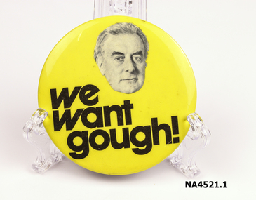
Badge - Badges, 1970s
Used during the 1972 Election1. We Want Gough. Yellow plastic on metal (tin) badge with pin for attachment on back of badge. Large 512C black writing. Drawing image of Gough Whitlam. 2. We want Gough. Orange background, black writing with pin on back. 3. Its Time. Black background, orange writing with pin on back.We Want Gough / We Want Gough / Its Timenumismatics, badges -
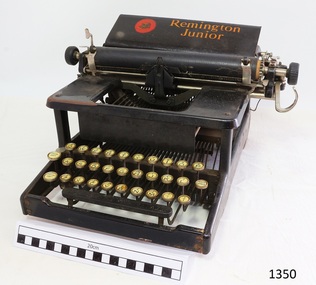 Flagstaff Hill Maritime Museum and Village
Typewriter, Remington Typewriter Company, Division of Remington Rand Inc
Typewriter branded "Remington Junior" in hard case lined with blue flet and a press-studded pocket inside, Full board of 3 rows of keys including space, Figure Shift and Capital SShift. Word spacing is non-operative. Trade Mark motto "TO SAVE TIME IS TO LENGTHEN LIFE" and "REMINGTON TYPEWRITER". Trade Mark motto "TO SAVE TIME IS TO LENGTHEN LIFE" and "REMINGTON TYPEWRITER. "flagstaff hill, warrnambool, shipwrecked-coast, flagstaff-hill, flagstaff-hill-maritime-museum, maritime-museum, shipwreck-coast, flagstaff-hill-maritime-village, typewriter, remmington junior, office machine, communicaitons, business -
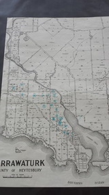 Peterborough History Group
Map - Map of Curdies River Inlet district, Narrawaturk
Shows the allotment boundaries and names of landowners at the timeSignificant as it shows owners of rural land in the Peterborough area.Photocopy of an old mapHandwritten notes and markings on the map.peterborough, curdies river, curdies river inlet, old maps, maps, narrawaturk -
Clunes Museum
Administrative record - DOCUMENTS, UNKNOWN
Nil.1 International time recorder ribbons in cardboard box .2 Instruction sheet "International Dial Recorder, printed in USA .3 Interknit Hosiery Co. Ltd., Clunes pay slips for Holiday Pay 1954.1 printed in black ink 1&1/4" x 4" International Time Recorder Ribbons operating instructions, interknit hosiery co. ltd., bundy clock -
 City of Moorabbin Historical Society (Operating the Box Cottage Museum)
Flyer - Ozone Hill Estate, Cheltenham, 1923
The train line from the city to Frankston was electrified in 1922 which intensified the sale in the municipality of Moorabbin, particularly land which was in the vicinity of the railway stations.Example of the progress of the Municipality of MoorabbinPhotocopy of Advertising flyer for sale of real estate sales - plan of building blocks for saleOzone Hill Estate, Cheltenham 41 choice residential allotments.victor avenue, weatherall road, cheltenham, real estate, auction -
 Falls Creek Historical Society
Plan - Leases of part of Falls Creek Tourist Area
Bob (Herman) Hymans (a former member of the Royal Netherlands Navy was born in Bloemendaal, Holland on 30th September 1922. During World War II he fought against the Japanese in the Dutch East Indies (now Indonesia) and was imprisoned in Changi and on the Burma Railway. After gaining qualifications as a Ski Instructor, Bob arrived in Falls Creek in May 1950. Working as an Instructor and Supervisor at Bogong Lodge, Bob decided his future was in accommodation. He was successful in negotiating an indenture for land from the State Electricity Commission (SEC). It took Bob two years to build his Grande Coeur Chalet but, tragically, it was burned down in August 1961. Bob also built the first Chairlift in Australia. This was a single chairlift and the structure was built from wooden electricity poles. He was constantly full of new ideas and proposals for the village. Bob Hymans died on 7th May 2007. This Collection of documents and letters tells the story of Bob’s endeavours to develop Falls Creek into the ski village it is today. This map is significant because it documents boundaries of early leases in Falls Creek Tourist Area.This map is part of Bob Hymans documents. It is a large Surveyor's Plan of a section of the Falls Creek Tourist Area. It is endorsed by J Parker, Chief Surveyor of the State Electricity Commission of Victoria on 27-3-84. It shows streets, lot numbers and measurements. It was a compilation created from existing lease maps. Heading - PART OF FALLS CREEK TOURIST AREA PART OF CROWN ALLOTMENT 1 PARISH OF CARRUNO PART OF CROWN ALLOTMENT 1 PARISH OF DARBALANG COUNTY OF BOGONGmap of falls creek, falls creek leases, falls creek 1980s -
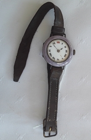 Mont De Lancey
Accessory - Watch, Cyma, 1900's
Presumed worn by Mrs C.V Schooling as noted written on the piece of paper underneath the burgundy mount inside the case.A ladies watch with a purple patterned enamel surround, a white face and black roman numerals surrounded by tiny gold dots around the edge of the face. It has a metal grooved winder on the right of the face which moves the hands but the watch doesn't keep time. The wristband is brown leather with a Reg. No on the back and has a gold coloured buckle. Is is in its original lidded case - CYMA brand, although the brand is not written on the watch itself. The case has a purple label on the top lid with an illustration of a black and gold watch with gold roman numerals behind it. CYMA - on time all the time is written below. Inside the lid is the brand and a statement about the guarantee. It sits on a burgundy velvet mount. Underneath the mount is a handwritten message from the wearer stating that the watch doesn't keep time. On the bottom of the box is writing in grey pencil with many words indecipherable. Some ink words are seen.CYMA - on time all the time is written on the top of the case lid. Inside the lid is written - CYMA - This Cyma watch is free from any defect of construction and is guaranteed to keep accurate time if not misused. On the small piece of paper under the burgundy mount is written - The watch was gaining 4 or 5 hours a day - then stopped, I do hope it can be made to go again - CVS, From Mrs C.V Schooling, Penshurst. On the back of the leather band is imprinted Reg No Victor 2watches, timepieces, watchbands, watchcases -
 Queenscliffe Maritime Museum
Plaque - Brass Plate
Recovered from wreck of SS TimeBrass door plate from SS Time with "Crew" inscribed on frontCREWss time, door plate -
 Geelong Cycling Club
Trophy, Cup
This cup was presented by the Geelong West Amateur Cycling Club to the cyclist with the fastest time in 1934. It was donated by the Radford family.Cup won by Eric Radford in a race promoted by the Geelong West Amateur Cycling Club in 1934. The professional Geelong West Cycling Club included an amateur chapter in the middle 1930s at a time when amateurism was flourishing. Eric Radford went on the set up in business in the cycle trade in Elizabeth street Geelong West until the middle 1970s.Silver cup with a handle to each side. The cup has milled edges and the base in brown bakelite or plastic."G.W.A.C.C. FASTEST TIME 1934/E. RADFORD"geelong cycling club; geelong west cycling club; trophy; cup; e. radford; -
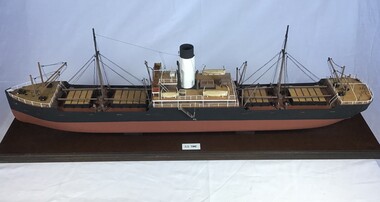 Queenscliffe Maritime Museum
Leisure object - Model SS Time, Jim Sutherland
10.00AM - Received call to prepare and proceed to S. S. Time aground on Corsair Rock with other members of salvage party. Took taxi home to pick up warm clothing and gear returning at once to Fleet Forge works. Arrangements made to board tug Eagle at 5 North Wharf at 1.30PM with diving gear and salvage pumps.Scale model of SS timess time, wrecks, port phillip, corsair rock, model ship -
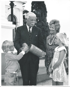 Melbourne Legacy
Photograph - Photo, Governor of Victoria, 1974
A photo of a the Governor of Victoria, Sir Rohan Delacombe with two children and a mother. He is holding a time capsule with the date and his name on it. Presumably the capsule was being interred and the Legacy children were involved. A record of relationship of Legacy with the Governor of Victoria.Black and white photo of the Governor with a time capsule.Stamped in purple ink on reverse "16 Jan 1974" and "John Squire Photography / 633 Rathdowne Street / N. Carlton - Phone 347 4922 / Neg No." "B1539-10" in pencil.governor of victoria, time capsule -
Stawell Historical Society Inc
Map, Special Allotments, Reefs, Pleasant Creek
Special Allotments, Reefs, Pleasant Creekstawell -
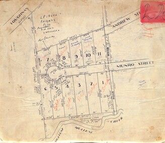 Ringwood and District Historical Society
Map, Subdivision Plan of residential allotments in Munro Street, Ringwood, Victoria - (Undated, circa 1920s)
Map of residential allotments on cardboard backing.Handwritten notations include sales information and title references LP1884, Vol 6602, Fol 132038, with number of units on lots 8, 9 and 10. -
 Queenscliffe Maritime Museum
Furniture - Captain's Desk
On August 23rd, 1949, S. S. TIME was on voyage from Sydney to Melbourne with a cargo of sugar (3,000 tons), timber, general cargo and coal, when she was wrecked on Corsair Rock, entrance of Port Philip Bay. Read more at wreck site: https://wrecksite.eu/wreck.aspx?57395The remnants of the Time remained as a landmark for over 10 years before a storm sent her remains to the bottom. http://home.vicnet.net.au/~maav/diary3.htmCaptain's desk from the SSW Timess tme, shipwrecks, salvage, furniture -
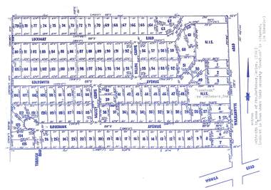 Ringwood and District Historical Society
Map, Subdivision Plan - Rosebank Avenue area, North Ringwood, Vic. - circa 1960s
Single page plan printed on green background showing allotments included in un-named subdivision layout surrounding "Rosebank" property, Warrandyte Road, Ringwood North. Subdivision includes Through Road, Rosebank Avenue, Macey Grove, Goldsmith Avenue, Dillon Grove, Lockhart Road, and Warrandyte Road.Typewritten notation against "Rosebank" property - "Mrs Godbehear, Snr.". "Goldsmith is maiden name of Mrs. Godbehear, Senior. (1960). Lockhart is town where their property "Rosebank" is situated. (In Riverina)". Additional Rosebank Avenue allotments blueprint clipping on light cardboard backing incldes handwritten title reference LP57659. -
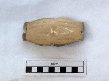 Geelong Cycling Club
Badge, 1946
The badge attaches to a silk sash to be worn by the Championship winner.Best rider for 1946 is acknowledged appropriately.Silver Sash Badge. The badge is a rectangular shape and has a pin on the back to attach it to a sash. It has inscriptions of the winner, time and the type of cycling race engraved on it. It also has a wheel with wings engraved in the background. "Geelong West Cycling Club/10 Mile Senior Championship Won by D Martin 1946 Time 26min52secs" "Wheel with Wings'sash badge; geelong west cycling club; 10 mile senior championship; d martin; 1946; -
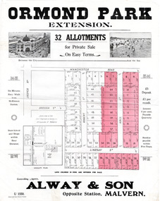 City of Moorabbin Historical Society (Operating the Box Cottage Museum)
Flyer - Ormond Park Extension, Ormond, 1924
The train line from the city to Frankston was electrified which intensified the sale in the municipality of Moorabbin, particularly land which was in the vicinity of the railway stations.Example of the progress of the Municipality of MoorabbinAdvertising flyer for auction of real estate sales - plan of building blocks for saleOrmond Park Extension - 32 Allotment for Private Sale - Alway & Sonmanchester road (now mckinnon road), lindsay street, hall street, ormond, real estate