Showing 112895 items
matching tracks/roads
-
 Glen Eira Historical Society
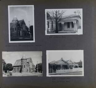
Album - Album page, Orrong Road, Circa 1972
This photograph is part of the Caulfield Historical Album 1972. This album was created in approximately 1972 as part of a project by the Caulfield Historical Society to assist in identifying buildings worthy of preservation. The album is related to a Survey the Caulfield Historical Society developed in collaboration with the National Trust of Australia (Victoria) and Caulfield City Council to identify historic buildings within the City of Caulfield that warranted the protection of a National Trust Classification. Principal photographer thought to be Trevor Hart, member of Caulfield Historical Society. Most photographs were taken between 1966-1972 with a small number of photographs being older and from unknown sources. All photographs are black and white except where stated, with 386 photographs over 198 pages. Victorian Heritage Database H0704 FORMER UNION CHURCH 84-86 ORRONG ROAD ELSTERNWICK https://vhd.heritagecouncil.vic.gov.au/places/428 The Former Union Church, Elsternwick, designed by the architect George de Lacy Evans, and erected in 1889-90 is a building of historical and architectural significance for the following reasons:- (1) it is a rare and well- developed example of the early French Gothic manner as popularised through the muscular Victorian re-interpretation of English architect William Burgess, which in turn were derived from the publications of EE Viollet-le-Duc. Other Victorian cases of detailing derived from Viollet-le-Duc include Barwon Park (1868), the Presbyterian Church at Skipton (1871), the Bourke Street West Police Station by Bindley and Brittingham (PWD) dating from 1888-9 and the Lutheran Manse, East Melbourne by JAB Koch (1890). However, none of these buildings relates closely in form to the Union Church, Elsternwick. The only building which has been identified as closely comparable is The Bairnsdale Court House by AJ Macdonald (PWD) which dates from 1892. (2) the use of bright red brickwork is of significance, as the Former Union Church is believed to be only the second church building in Victoria to employ this material as a matter of conscious choice. Amongst red brick churches, it is thought to be preceded only by Reed, Henderson And Smart's Sacred Heart (1884), a Renaissance inspired design. (3) the building is believed to be a rare, possibly unique, surviving example of a church building erected for dual use by the Congregationalists and Baptists. In 1894 it was bought by the Congregationalists and continued as a Congregational Church until the formation of the Uniting Church.Page 165 of Photograph Album with four photographs, two of a church with the other two of houses on Orrong Road.Handwritten: ELSTERNWICK CONGREGATIONAL CHURCH [under top left photo] / 82 ORRONG ROAD [under top right photo] / 663-1 ORRONG ROAD / SEMI - DETACHED PAIR / 165 [bottom left]trevor hart, elsternwick congregational church, king street, orrong road, church, elsternwick, red brick, former union church, early french gothic style, architects, george de lacy evans, baptist church, conical towers, houses -
 RMIT Design Archives
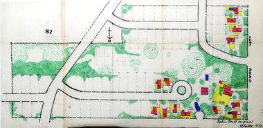
Work on paper - Architectural drawings, Colour plan of Lum road estate, 1970-1986
This plan of Lum Road Estate includes layout of roads, gardens, building and carparks. From 1970 until August 1971 Robin Boyd and his practice Romberg & Boyd Architects worked on designs for housing on the Lum Road Estate, Wheelers Hill. Berenice Harris, Linley Vellacott and Karl Fender drew many of the sketch plans for the project homes, while Robin Boyd drew the perspectives. This colour plan of the estate was drawn by Robin Boyd, but not signed. Frederick Romberg later annotated the drawing with details of its authorship. Colour plan of Lum road estate. Includes layout of roads, gardens, buildings and flora.Inscribed lower right on recto in black ink, 'Robin Boyd original / 12/6/86 F.R' ; Inscriber upper left on recto, grey pencil, '3400'.architecture, design, rmit design archives, domestic architecture -
 Sunbury Family History and Heritage Society Inc.
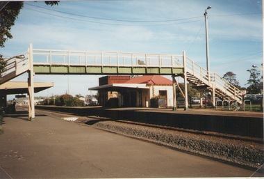
Photograph, Elwyn Davis, Pedestrian Bridge, C1990s
The wooden pedestrian bridge spanned the rail tracks at Sunbury Railway Station and were replaced with a more modern bridge and ramp when upgrades were done at the station and along the Bendigo line in the late 1990s and early 2000s. The water tank beyond the station building was used to refill the engines with water when steam engines were used. Diesel driven V Line trains now convey commuters from the regional towns along the Bendigo region to Melbourne.The Bendigo Line was the first government rail line to open and it reached Sunbury in 1859. It was extended to Bendigo and opened in 1861.A non-digital coloured photograph of a wooden pedestrian bridge spanning rail tracks with a wooden station building and former water tower on the station platform. rail bridges, bendigo rail line, sunbury station, water towers, railways -
 Ballarat Tramway Museum
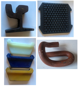
Equipment - Tram Track Materials, Pandrol Australia, Sydney
Tramway Track materials used to reconstruct or replace Ballarat Tramway Museum track between Carlton St and Depot Junction Sept 2019. Follows the current practice in Melbourne.Demonstrates the materials used to replace BTM Tramway Track during 2019. Same materials used during the reconstruction of 2022.Group of rail fittings used during 2019 track relay by Fulton Hogan between Carlton St and Depot Junction. .1 - Section of tram rail - Ri57A - cut from an 18m long rail section. Rolled by voestalpine Railway Systems, Austria .2 - Group of three different sized Pandrol Rail insulators used between the rail and the clip. .3 - Pandrol resilient pad used between the concrete sleeper and the rail .4 - Pandrol clip used to secure the rail to the sleeper.tramways, ballarat, btm, trackwork, tramway rails, pandrol, voestalpine -
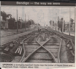 Bendigo Historical Society Inc.
Newspaper - JENNY FOLEY COLLECTION: UPGRADE
Bendigo Advertiser ''The way we were'' from 1999. Upgrade: a workgang lays tram tracks near the corner of Hayes Street and Eaglehawk Road, Ironbark, about 1902.newspaper, bendigo advertiser, the way we were -
 Whitehorse Historical Society Inc.
Article, Family Digs In Over Land, 2016
The level crossing removal Authority intended to use a narrow strip of land next to the railway tracks in Heatherdale Road only to discover that it was privately owned and negotiations are proceeding with the owners.The level crossing removal Authority intended to use a narrow strip of land next to the railway tracks in Heatherdale Road only to discover that it was privately owned and negotiations are proceeding with the owners.The level crossing removal Authority intended to use a narrow strip of land next to the railway tracks in Heatherdale Road only to discover that it was privately owned and negotiations are proceeding with the owners.heatherdale railway station, level crossing removal authority -
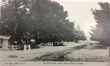 Phillip Island and District Historical Society Inc.
Photograph, The Beach Road, Ccowes
Part of a collection of 'Rose & Valentine' series of Post Cards. Copied by John Jansson 1984View along the Beach Road, Cowes looking towards the Isle of Wight Hotel on left of photograph (hidden by the trees).The Beach Road, Cowes Phillip Island Vic. The Rose Series P.674.local history, photography, photographs, postcards, cowes, phillip island, black & white photograph, the esplanade cowes, isle of wight hotel -
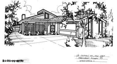 Hawthorn Historical Society
Drawing - Property Illustration, 1/ 6 Clifton Road, Hawthorn East
'After training as a Cartographic Draftsman within the mining industry, I worked as a property illustrator for real estate firms in the eastern suburbs of Melbourne for 23 years from 1983. I initially photographed houses with a Polaroid camera and made a 'thumbnail' sketch while there. The photos were used to scale off a sketch in pencil and then that sketch was overlaid with drafting film and the 'pen and ink' completed. The pens I used were the Rotring ‘Rapidigraph’ drafting pens. The ink was also made by Rotring (German).The film was ‘Rapidraw’, polyester drafting film, double matte. It takes a very fine line and doesn’t bleed. As well as house sketches, there were often floor plans and site plans ordered. Aerial sketches were ordered when the property needed an overall view.' (Margaret Picken, 2020)This property illustration is one of a series created by Margaret Picken for a range of real estate agents in Melbourne between c. 1983 and c. 2006. Each work is signed and dated by the artist.Gift of Margaret Picken, 2020Pen and ink property illustration on drafting film of 1/6 Clifton Road, Hawthorn East by Margaret Picken.1/ 6 Clifton Road, Haw East, Margaret Picken '89. Woodards. artist - margaret picken 1950- -
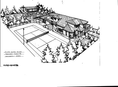 Hawthorn Historical Society
Drawing - Property Illustration, 17 & 17A Clifton Road, Hawthorn East
'After training as a Cartographic Draftsman within the mining industry, I worked as a property illustrator for real estate firms in the eastern suburbs of Melbourne for 23 years from 1983. I initially photographed houses with a Polaroid camera and made a 'thumbnail' sketch while there. The photos were used to scale off a sketch in pencil and then that sketch was overlaid with drafting film and the 'pen and ink' completed. The pens I used were the Rotring ‘Rapidigraph’ drafting pens. The ink was also made by Rotring (German).The film was ‘Rapidraw’, polyester drafting film, double matte. It takes a very fine line and doesn’t bleed. As well as house sketches, there were often floor plans and site plans ordered. Aerial sketches were ordered when the property needed an overall view.' (Margaret Picken, 2020)This property illustration is one of a series created by Margaret Picken for a range of real estate agents in Melbourne between c. 1983 and c. 2006. Each work is signed and dated by the artist.Gift of Margaret Picken, 2020Pen and ink property illustration on drafting film of 17 & 17A Clifton Road, Hawthorn East by Margaret Picken.17 & 17A Clifton Road, Haw, Margaret Picken '92. Woodards - C'well.artist - margaret picken 1950- -
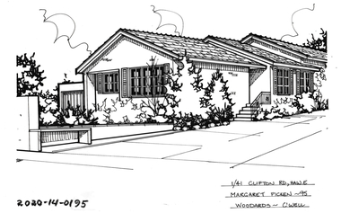 Hawthorn Historical Society
Drawing - Property Illustration, 1/ 41 Clifton Road, Hawthorn East
'After training as a Cartographic Draftsman within the mining industry, I worked as a property illustrator for real estate firms in the eastern suburbs of Melbourne for 23 years from 1983. I initially photographed houses with a Polaroid camera and made a 'thumbnail' sketch while there. The photos were used to scale off a sketch in pencil and then that sketch was overlaid with drafting film and the 'pen and ink' completed. The pens I used were the Rotring ‘Rapidigraph’ drafting pens. The ink was also made by Rotring (German).The film was ‘Rapidraw’, polyester drafting film, double matte. It takes a very fine line and doesn’t bleed. As well as house sketches, there were often floor plans and site plans ordered. Aerial sketches were ordered when the property needed an overall view.' (Margaret Picken, 2020)This property illustration is one of a series created by Margaret Picken for a range of real estate agents in Melbourne between c. 1983 and c. 2006. Each work is signed and dated by the artist.Gift of Margaret Picken, 2020Pen and ink property illustration on drafting film of 1/41 Clifton Road, Hawthorn East by Margaret Picken.1/41 Clifton Road, Hawthorn, Margaret Picken '95 Woodards - C'well. artist - margaret picken 1950- -
 City of Kingston
Pamphlet - Colour, Duffus Bros, Railway Reserve Highett, c. 1923
Sales plan for land in the suburb of Highett, titled Railway Reserve, incorporating properties along Wolseley Street, Livingston Street, Highett Road and Worthing Road. The developing urban area of Highett within the City of Kingston. This land sale pamphlet illustrates the subdivision of land within the municipality and the changing demographic of the district as new houses and shops are constructed close to infrastructure.Colour pamphlet advertising thirty eight shop and villa sites for sale at the Railway Reserve, Highett. Incorporates a map of the reserve with properties available on Wolseley Street, Livingston Street, Highett Road and Worthing Road. Handwritten in grey pencil: assumed sale price recorded on subdivisions 1-7, 10, 22, 23 and 34 Handwritten in grey pencil on subdivision 4: C. Nevill / City of Melbourne bank Handwritten in grey pencil across subdivision 7: 49' Handwritten in grey pencil across subdivision 21 and 22: 134' Handwritten in grey pencil across subdivision 25 and 26: 200' Handwritten in grey pencil across subdivision 36 and 37 and both top and bottom: 120' Hand drawn in blue pencil: outline of subdivision 4 Hand drawn in blue pencil: outline of subdivisions 7, 23, 28, 37, 38 along left hand side, subdivisions 38, 37 and 36 on Wolseley Street, subdivisions 30 and 29 along Wolseley Street, subdivisions 29 and 24 along the middle of the plan, subdivisions 24 and half of 25 along Livingston Street, half of subdivision 20 along the middle of the plan, subdivisions 21 and 22 along the Right of Way between Livingston Street and Highett Road, and along the right hand border of subdivision 7. Handwritten in ink adjacent to the subdivision plan, updside down, in the bottom right hand corner: 276 / 54 / 280 / 45 / 320 / 202 / 200 / 134 / horizontal line / 11/14 Handwritten in ink adjacent to the subdivision plan, updside down, in the bottom right hand corner: 1714)2200(15 / 1714 / horizontal line / 486land sales, highett -
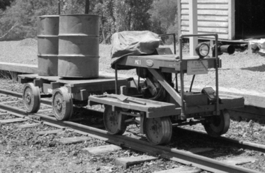 Puffing Billy Railway
ME1, Victorian Railways 2'6" Gauge Trolly, 1958
It was constructed on a former Victorian Railways NKS type underframe and powered by a single cylinder, 500 cc B.S.A. side valve motorcycle engine to drive axle by roller chains through an 'Ariel Square Four' gearbox and has traveled on all four 2'6" narrow gauge lines that operated in the state of Victoria.Historic - Narrow Gauge Railway - Track Patrol Vehicle used by Puffing Billy Preservation Society and made from parts of a Victorian Railways track patrol vehicleMotorised small rectangular trolly made of wood and wrought iron ME1 P.B.P.S Track Construction Departmentme 1, trolley, victorian railway, 2'6" gauge, puffing billy, trolly -
 Hume City Civic Collection
Photograph
A black and white photograph of a weatherboard house and garden known as Bayview Farm at Diggers Rest. It is the home of Uraina and Eileen Cullinan situated at 111 Davis Road, Diggers Rest.on back: BAYVIEW / 111 DAVIS ROAD / DIGGERS RESTcullinan, uraina, eileen, diggers rest, bayview farm, chris, davis road, george evans collection -
Whitehorse Historical Society Inc.
Article, Community Centre Celebrates 40 years, 2015
Mitcham Community House celebrates 40 years.Mitcham Community House celebrates 40 years after being established at Mountview House on Whitehorse Road and moving to Brunswick Road, Mitcham in 1996.Mitcham Community House celebrates 40 years. mitcham community house, mountview presbyterian church, mitcham, mountview uniting church, mitcham -
 Ballarat Tramway Museum
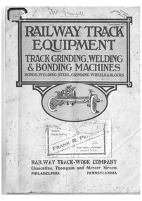
Document - Folder with papers, Railway Track-work Company and Clementine and Thompson and Mercer Sts and Philadelphia and Pennsylvania USA. and Perrot and Adams Ltd, "Railway Track Equipment - Track Grinding Machines, Welding and Bonding Machines - Bonds, Welding Steel, Grinding Wheels and Blocks", 1920's?
Yields information about the type and presentation of books or information folders that were sent to the Electric Supply Company of Victoria about tramway products available on the market and the company the produced them.Folder with 24 pages of advertising pamphlets bound into it with two metal clip binders advertising products available from the Railway Track-Work Company and titled ""Railway Track Equipment - Track Grinding Machines, Welding and Bonding Machines - Bonds, Welding Steel, Grinding Wheels and Blocks". Has brochures or pamphlets for: . The Universal Rotary Track Grinder . Reciprocating Track Grinder . The Atlas Rail Grinder . The Ajax Electric Arc welders .Vertical Rail Lifter . The Jackson Electric Tie Tamper. Generally the lead page of each pamphlet has been imaged. Provides a description of each item, along with method of operation and parts listing generally. The folder has on a number of pages and the back cover, a sticker from Frank R. Perrot (Now Perrot and Adams Ltd), Machinery Merchant of 394 Kent St Sydney. Railway Track-work Company , Clementine, Thompson and Mercer Sts, Philadelphia, Pennsylvania USA. For a full scan of the document see the hi res file.Numerous: Front cover sticky label "1620" in top left hand corner, "Mr Pringle" on front cover and stamp with words "Ballarat Tramway Preservation Society Catalogue No. 10" in ink on front cover. Inside front cover has a pencil note, behind the crease in the bottom right hand corner. On the first pamphlet "Ballarat Tramway Preservation Society Catalogue No. 10" in ink on top right hand corner. On parts page for the Reciprocating Track Grinder has the "Perrot and Adam Ltd" company stamp.trams, tramways, trackwork, equipment, rails -
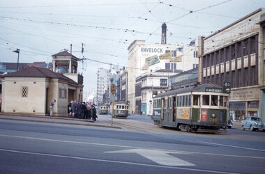 Melbourne Tram Museum
Slide - Set of 2, John Webster, 21/07/1959 12:00:00 AM
Set of two Colour slides, Kodak, white cardboard of trams of trams at the Victoria St / Swanston St shunt. 21-7-59. .1 - W2 340 showing East Malvern Darling road opposite the signal box followed by W2 showing route 4. Has a large number of men and school boys at the stop. In the view is a "No Entry" sign. In the background is the Ansett ANA building and a building advertising Havelock Tobacco. The tram has a Pimms No. 1 advert. .2 - W2's 550 (with a Castrol sign), 340 - as above and 358 (route 8, Toorak - Glenferrie Road) in the Victoria St shunting area. Has the Army hall behind the trams.Hand writing on rear in ink; "21-7-59 - KFB2 - TRACK - KEV - Swanston St near Victoria St Melbourne" "21-7-59 - KFB3 - TRACK - KEV - Trams in Victoria St Melbourne" Both slides have the speed and the f reading on the left hand side.trams, tramways, victoria st, swanston st, signal box, route 4, route 8, route 4d, east malvern, tram 550, tram 358, tram 340 -
Whitehorse Historical Society Inc.
Map, The Parish of Nunawading, 1853
Photocopy of manuscript plan with allotments numbered and some named.Photocopy of manuscript plan with allotments numbered and some named. Note on verso: The Parish of Nunawading in the County of Bourke; lithographed at the Surveyor General's office by J.Jones Jan 18th 1853. Endorsed Sale Plan 271. Dray tracks, water holes and terrain indicated.Photocopy of manuscript plan with allotments numbered and some named. land subdivision, maps, parish of nunawading, jones, j -
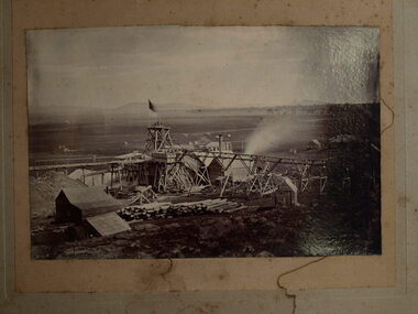 Clunes Museum
Photograph, TALBOT, 1865
SEPIA PHOTOGRAPH UNION CLAIM 1865 DUNACH. NO ROAD TO TALBOT FROM CLUNES.. J.KERWIN OF CHALMON AND KERWINUNION CLAIM 1865 DUNACH. NO ROAD TO TALBOT FROM CLUNES.. J.KERWIN OF CHALMON AND KERWINlocal history, photography, photographs, mining -
Tarnagulla History Archive
Postcard - Photographic postcard: Commercial Road, Tarnagulla looking south from Poverty Street, c. 1910
Williams Family Collection. Photographic postcard, front image depicting Commercial Road, Tarnagulla looking south from Poverty Street. Handwritten on reverse: '1/2 main street, Commercial Road, Tarnagulla' and 'L.Williams Tarnagulla'tarnagulla -
 City of Kingston
Pamphlet - Colour, Arthur Tuckett & Son, Auctioneers and Subdivisional Specialists, Auction of Station Estate, Moorabbin, 1923
Sales plan for land in the suburb of Moorabbin, bounded by Railway Crescent, South Road, Jasper Road and Pattersons Road.The developing urban area of Moorabbin within the City of Kingston. This land sale pamphlet illustrates the subdivision of land within the municipality and the changing demographic of the district as new houses are constructed.Colour pamphlet advertising an auction of the Station Estate Moorabbin. Incorporates details of the shopping facilities, proximity to the railway line, variety of schools and churches in the area, and a sales plan for home sites and shop fronts. Incorporates a map of the estate bordered by Pattersons Road, Japer Road, South Road and Railway Crescent. Handwritten in grey pencil top right front page: Station Estate / late [indecipherable] Handwritten in red pencil on subdivision map: x [on majority of properties marked on the map] Handwritten in grey pencil on subdivision map: additional subdivisions drawn in and large lines drawn across the mapmoorabbin, land sales, estate -
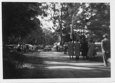 Halls Gap & Grampians Historical Society
Photograph - B/W, C 1950
Halls Gap Grampians Camping reserve on Flower Show Day in 1950. This is the main road looking towards the stores from Grampian House.The photo shows a road with trees growing on either side. There are cars parked on either side of the road and people standing and walking along the road. In the centre there are two cars driving along the road towards the camera.events, wildflower show -
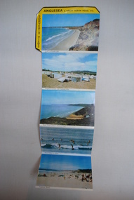 Anglesea and District Historical Society
Souvenir Postcards, Viewpoint Productions Pty. Ltd, 1950's and 1960's
Folder of 9 photographs of Anglesea and Great Ocean Road. 5 in colour and 4 black and white with provision for note to be written if posted and description of location of Anglesea and amenities and attractions to be found there.ANGLESEA & Great Ocean Road, VIC / SOUVENIR VIEWSanglesea, aireys inlet, great ocean road, postcards -
 Ballarat Tramway Museum
Photograph - Black & White Photograph/s, Geoff Grant, 1954
Yields information about one of the MMTB scrubbers, No. 8, trams after it was repainted to the MMTB work tram colour scheme. This tram is now at the Museum.Black and White photograph of MMTB Scrubber tram No. 8 in Dandenong Road, Caulfield March 1954. Geoff Grant photo. On rear in ink " 8 in Dandenong Road, Caulfield March 1954. G A Grant "trams, tramways, scrubber tram, livery, work trams, dandenong road, tram 8 -
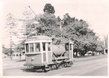
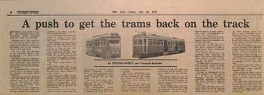 Melbourne Tram Museum
Newspaper, The Age Newspaper, "A push to get the trams back on the track", 30-7-1976
Reports on Federal and State Transport Ministers conference, the need to push public transport. Reports on the new Z class trams, extensions to Burwood Road and East Preston. Quotes Dudley Snell, MMTB Chairman, about fares, bus costs, income, and one man buses,use of barriers in Nicholson St, underground trams not useful. Written by Stephen Nisbet Transport Reporter.Yields information about the outlook and issues of trams and buses in Melbourne in the mid 1970s.Newspaper clipping - "A push to get the trams back on the track" - The Age 30-7-1976tramways, trams, melbourne, public transport, one man buses, extensions, east preston, burwood road, dudley snell, bus costs, underground tramways, z class trams -
 Eltham District Historical Society Inc
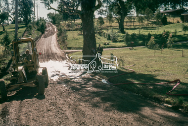
Slide, In Bonds Road looking north at intersection with Montpelier Drive, Lower Plenty, 18 July 1972, 1972
Water drainage work undertaken by Eltham Shire Council in Bonds Road, Lower Plenty outside the Martin property opposite Montpelier Drive, July 1972 Note water flooding across Bonds Road and pile of material removed from the pit on the east side of Bonds Road.35 mm colour positive transparency Mount - Agfacolor Service (Blue)Bonds Road (Martin property) 12.10 pm 18.7.72bonds road, drainage works, eltham shire council, infrastructure, lower plenty, martin property, montpelier drive -
 Glen Eira Historical Society
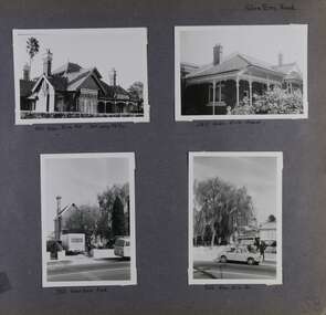
Album - Album page, Glen Eira Road, Circa 1972
This photograph is part of the Caulfield Historical Album 1972. This album was created in approximately 1972 as part of a project by the Caulfield Historical Society to assist in identifying buildings worthy of preservation. The album is related to a Survey the Caulfield Historical Society developed in collaboration with the National Trust of Australia (Victoria) and Caulfield City Council to identify historic buildings within the City of Caulfield that warranted the protection of a National Trust Classification. Principal photographer thought to be Trevor Hart, member of Caulfield Historical Society. Most photographs were taken between 1966-1972 with a small number of photographs being older and from unknown sources. All photographs are black and white except where stated, with 386 photographs over 198 pages. Page 58 of Photograph Album with four photographs of three different properties on Glen Eira Road.Hand written: Glen Eira Road [top right] / 105 Glen Eira Rd 3rd July 1972 [under top left photo] / 245 Glen Eira Road [under top right photo] / 356 Glen Eira Road [under bottom left photo] / 356 Glen Eira Rd [under bottom right photo] / 58 [bottom right] trevor hart, glen eira road, caulfield north, victorian, streetscape, cars, verandahs -
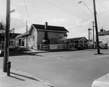 City of Kingston
Photograph - Black and white, c. 1969
Black and white photograph of level crossing gates and railway station at Bentleigh at the intersection of Burgess Street and Centre Road. This image is part of a larger collection of images from the Public Transport Corporation displaying train stations and streetscapes in what is now the City of Kingston.Black and white photograph of level crossing gates and railway station at Bentleigh at the intersection of Burgess Street and Centre Road.Stamped in blue ink on reverse: COPYRIGHT / Public Transport Corporation / For re-ordering photographs / Please quote negative No H3405 / Enquiries C/- PTC Photographic Unit / Telephone switchboard 619 111 White paper adhered to reverse of photograph with black typed text: Railway gates, Centre Road Bentleigh / 1969 / $50 reproduction fee appliesbentleigh, railway station, railway crossing, suburbs, public transport -
 Kew Historical Society Inc
Document - Urban Planning Document, City of Kew, City of Kew : Minimum Size of Allotment Required, 1945-1955
A document outlining the relevant by-laws produced by the City Of Kew to regulate the minimum size of allotments in Barkers Road, Burke Road, Cotham Road, Glenferrie Road and Studley Park Road, as well as in other streets more generally. The by-laws specify the size of allotments in which single unit dwellings, attached houses and maisonettes, and flats could be built. In the ‘main streets’ a minimum land area for single unit dwellings was 8,100 square feet, with an average frontage of 60’ and a depth of 135’. In other streets this was reduced to an overall size of 6,250 square feet, with an average dimensions of 50’ x 125’. In specifying the land area required by flats, different sizes were regulated for the construction of between two and six flats. Six flats at the time when the regulations were passed must have been the upper limit permitted. Understanding the size of land listed in imperial measurements can be a challenge. Within Australia, the so-called quarter acre block was approximately 11,000 square feet. Those specified in the by-laws would appear to be smaller. The document was pasted on the reverse of a subdivision plan in the collection.This is a rare (undated) document produced by the City of Kew defining how subdivision within the municipality should occur. The document was created to constrain unbridled speculation in subdivisions in the various parts of Kew and East Kew.Undated typed document, issued by the City of Kew (1921-1994) indicating the minimum size of allotment required in Barkers Road, Burke Road, Cotham Road, Glenferrie Road and Studley Park Road. The document is mounted on board and waterstained. It was presumably used by a real estate agent. [Formerly catalogued as MAP.0066].city of kew - by-laws and regulations, subdivisions - kew - studley park -
 Ringwood and District Historical Society
Photograph, Our Lady of Perpetual Succour - Bedford Road, Ringwood - 1973, 1973
Our Lady of Perpetual Succour in Bedford Road in 1973Typed below photograph, "Our Lady of Perpetual Succour - Bedford Road. 30.9.73" Black and white photograph of brick church with sign outside. -
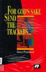 Victorian Aboriginal Corporation for Languages
Book, Gary Presland, For god?s sake send the trackers : a history of Queensland trackers and Victoria police, 1998
A history of Aboriginal trackers in Victoria, detailing a program of using trackers from Queensland in the period 1880-1968. Includes a list of known trackers with some photographs, and numerous histories of instances of trackers working with Victoria police.B&w photographs