Showing 1627 items matching "yarra river"
-
 Royal Brighton Yacht Club
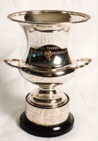
Cup, Alan Robinson Memorial Trophy (Cup)
... on the banks of the Yarra River. The race is a combined division race... of the Yarra River. The race is a combined division race from RBYC ...Alan Robinson Memorial Trophy (Cup) Donor : Keith Farfor Deed of Gift: No Alan Robinson was the navigator on Keith Farfor’s yacht Super Star. He was killed in a car accident on the banks of the Yarra River. The race is a combined division race from RBYC to the QCYC. The trophy is awarded to the PHD handicap winner and is raced early June of each year. First Winner: Bindi D Buxton alan robinson, memorial, trophy, phd, combined division -
 Warrnambool and District Historical Society Inc.
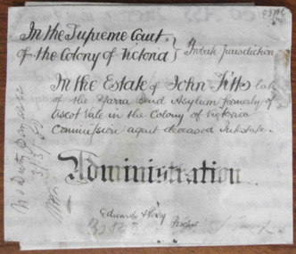
Document - John Fitts Letters of Administration 1879, 1879
... the junction of the Yarra River and the Merri Creek was the first... of the Yarra River and the Merri Creek was the first institution ...No information has been found on the Commission Agent John Fitts except that he died at the Yarra Bend Asylum at the age of 51 and was formerly a resident of Ascot Vale, a suburb of Melbourne. His estate was valued at £600. Yarra Bend Asylum, near the junction of the Yarra River and the Merri Creek was the first institution for the mentally ill in Victoria and operated from 1848 to 1925. Tait collection: item 5 of 62This document is only of interest in that it came from the former legal offices of Mackay Taylor in Kepler Street, Warrnambool. It originally came from Thomas Goodall, a legal clerk in the office of the lawyer Ernest Chambers who passed it on to George Mackay, the lawyer in the forerunner firm of Mackay Taylor where it remained until the firm of Mackay Taylor ceased to exist and the buildings were cleaned out. This is a piece of parchment paper with printed black lines and handwritten material in black ink. There is a fold at the bottom of the document with a seal of the Supreme Court of the Colony of Victoria attached by a green ribbon. The document is slightly discoloured but is otherwise in good condition. ‘In the Supreme Court of the Colony of Victoria, Probate jurisdiction, In the Estate of John Fitts, late of the Yarra Bend Asylum, formerly of Ascot Vale in the Colony of Victoria, commission agent, deceased intestate, Administration, Edwards and Perry, Proctors’yarra bend asylum, john fitts, warrnambool -
 Eltham District Historical Society Inc
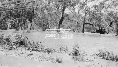
Photograph, Floodwaters, Diamond Creek, Eltham, 1934
... 1934 flood of the Diamond Creek and Yarra River set... 1934 flood of the Diamond Creek and Yarra River set ...The Diamond Creek in flood near the Main Road bridge at Eltham, Victoria. The Yarra also was in flood. In early December 1934 the "Greatest flood in the history of the Yarra" occured, according to The Argus newspaper. Bridges and houses were swept away with hundreds of people left homeless across the state. The historic 1934 flood of the Diamond Creek and Yarra River set the criteria for future planning with respect to flood water rise.This photo forms part of a collection of photographs gathered by the Shire of Eltham for their centenary project book, "Pioneers and Painters: 100 years of the Shire of Eltham" by Alan Marshall (1971). The collection of over 500 images is held in partnership between Eltham District Historical Society and Yarra Plenty Regional Library (Eltham Library) and is now formally known as 'The Shire of Eltham Pioneers Photograph Collection.' It is significant in being the first community sourced collection representing the places and people of the Shire's first one hundred years.Digital image 4 x 5 inch B&W Neg (2 frames on one neg) 9 x 15.5 cm B&W printflooding, eltham, shire of eltham pioneers photograph collection, sepp, diamond creek (river), floods, 1934 flood, diamond creek -
 Kew Historical Society Inc
Plan - Subdivision Plan, Kew Golf Links Estate, 1936, 1936
... Avenue, and Belford Road. The position of the Yarra River..., and Belford Road. The position of the Yarra River and a large Drainage ...The Kew Golf Links Estate was a major subdivision in North Kew. It derived its title due to the land being previously occupied by the Kew Golf Club, which transferred its course to a number of locations before occupying its current site. The Plan advertises 180 choice home sites. The street names are somewhat different today as those on the map are named after the proposed Kodak Factory to be built on the site. The subdivision of the Kew Golf Links Estate was a major subdivision of farmland in Kew. The site was at one stage designated for industrial development and the building of a new Kodak factory. The decision by Council to oppose the redevelopment makes the beginning of the period when all industrial development was banned in Kew.Monochrome printed, folded subdivision plan for the Kew Golf Links Estate, to be auctioned on 7 November 1936. Streets named include: Carnegie Avenue, Willsmere Road, Kilby Boulevarde, Kodak Avenue, Coleman Avenue, Beresford Avenue, McConchie Avenue, Cole Avenue, White Avenue, Baker Avenue, Spruzen Avenue, Tanner Avenue, Ratten Avenue, Mathers Avenue, Railway Avenue, Sutherland Avenue, and Belford Road. The position of the Yarra River and a large Drainage Reserve are marked on the plan. Lots for sale are numbered. Existing buildings are designated with a square.subdivision plans - kew (vic), kodak factory - kew (vic) -
 Melbourne Tram Museum
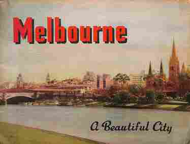
Book, Nucolorvue Publishing, "Melbourne - a Beautiful City", c1953
... Beach, Yarra River, and Elizabeth St...., the various parks, Royal Melbourne Hospital, St Kilda Beach, Yarra ...Published by Nucolorvue Productions of Mentone Melbourne, c1953 featuring colour photos of many locations in Melbourne, including an introduction. Has photos of Melburne landmarks, Collins St, Flinders St, Bourke St (with cable tram track), Flinders St Station, trams in streets, (W2 389, W5 777) St Kilda Road, the various parks, Royal Melbourne Hospital, St Kilda Beach, Yarra River, and Elizabeth St.Demonstrates a Nucolorvue production about Melbourne in the early 1950s.Book - 36 pages, colour printed, centre stapled. Printed on stippled paper.Has the stamp of "Queensland Book Depot, 61 Adelaide St Brisbane" on the inside front cover and pencil notes.mmtb, trams, tramways, souvenirs, melbourne, travel books -
 Melbourne Tram Museum
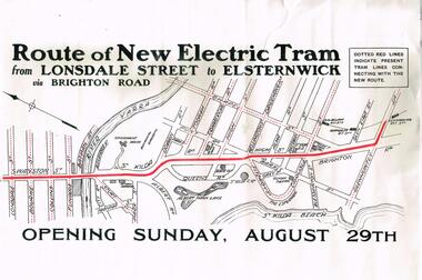
Poster, Melbourne & Metropolitan Tramways Board (MMTB), "Route of New Electric Tram from Lonsdale Street to Elsternwick via Brighton Road - Opening Sunday August 29th", Original 1926
... lines dotted, including the Yarra River. Given its condition... tram lines dotted, including the Yarra River. Given its ...Poster - special size, titled "Route of New Electric Tram from Lonsdale Street to Elsternwick via Brighton Road - Opening Sunday August 29th". Shows the tram rote in red and other tram lines dotted, including the Yarra River. Given its condition - a reproduction poster. From the Don Storey tram history notes - 1926 - 29 August - "he Elsternwick - St Kilda Junction line was opened, replacing the Brighton Road cable line together with an extension to Glenhuntly Road, and was built as double track." .1 - Laminated A3 version - added 30/6/2021trams, tramways, st kilda rd, brighton rd, lonsdale st, new tramway, conversion, elsternwick -
 Eltham District Historical Society Inc
Photograph, Eltham - Floods in 1934
... 1934 flood of the Diamond Creek and Yarra River set... 1934 flood of the Diamond Creek and Yarra River set ...To the left of picture is the Main Road Bridge over the Diamond Creek in Eltham South when the Diamond Creek was in flood. The Yarra also was in flood. In early December 1934 the "Greatest flood in the history of the Yarra" occured, according to The Argus newspaper. Bridges and houses were swept away with hundreds of people left homeless across the state. The historic 1934 flood of the Diamond Creek and Yarra River set the criteria for future planning with respect to flood water rise.This photo forms part of a collection of photographs gathered by the Shire of Eltham for their centenary project book, "Pioneers and Painters: 100 years of the Shire of Eltham" by Alan Marshall (1971). The collection of over 500 images is held in partnership between Eltham District Historical Society and Yarra Plenty Regional Library (Eltham Library) and is now formally known as 'The Shire of Eltham Pioneers Photograph Collection.' It is significant in being the first community sourced collection representing the places and people of the Shire's first one hundred years.Digital image 4 x 5 inch B&W Negsepp, shire of eltham pioneers photograph collection, eltham, diamond creek (river), 1934 flood, diamond creek, floods, main road bridge -
 Kew Historical Society Inc
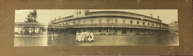
Photograph - Female Staff, Kew Hospital for the Insane, c.1929
... Bend Asylum on the Fairfield side of the Yarra River. Work... Asylum on the Fairfield side of the Yarra River. Work started ...Following a Royal Commission in 1854, the building of a new Asylum at Kew began in 1864. It was built to replace the Yarra Bend Asylum on the Fairfield side of the Yarra River. Work started in 1864 and was completed in 1872 at a cost of ₤198,334. Operating over a period of 116 years, and often renamed to take account of public sensitivities, the ‘Kew Lunatic Asylum’ was one of the largest asylums built in Australia. ‘Willsmere’ was finally closed in December 1988 and sold by the Government of Victoria in the late 1980s.A rare and historically significant photograph of female staff of the Kew Hospital for the Insane, in front of the central wing. The photograph is one of a pair donated to the Kew Historical Society by Frances Dorothea Van Brummelen (1931-2011) in 1994. Following her graduation as a social worker, Fran Van Brummelen joined the staff of Kew Cottages in 1969, and became senior social worker there in 1971. She remained at the cottages until she retired in 1994. Earlier, In 1987, with psychiatrist Cliff Judge, she founded the Kew Cottages Historical Society becoming its president. In 2002, the pair collaborated on the book Kew Cottages: the World of Dolly Stainer, which was later commended in the Victorian Community History Awards. Panoramic photograph of group of female staff in north courtyard, in front of Administrative Wingkew lunatic asylum, kew mental hospital, kew hospital for the insane, willsmere -
![The Fairfield Bridge [circa 1891]](/media/collectors/550653872162f11fb04854aa/items/579eab98d0cdd117c4af1c89/item-media/579eac23d0cdd117c4afb1ad/item-fit-380x285.jpg) Kew Historical Society Inc
Kew Historical Society IncPrint, The Fairfield Bridge [circa 1891], c. 1891
... "Outer Circle Railway Bridge over River Yarra at Fairfield... outer circle railway "Outer Circle Railway Bridge over River ...This work forms part of the collection assembled by the historian Dorothy Rogers, that was donated to the Kew Historical Society by her son John Rogers in 2015. The manuscripts, photographs, maps, and documents were sourced by her from both family and local collections or produced as references for her print publications. Many were directly used by Rogers in writing ‘Lovely Old Homes of Kew’ (1961) and 'A History of Kew' (1973), or the numerous articles on local history that she produced for suburban newspapers. Most of the photographs in the collection include detailed annotations in her hand. The Rogers Collection provides a comprehensive insight into the working habits of a historian in the 1960s and 1970s. Together it forms the largest privately-donated collection within the archives of the Kew Historical Society.A reproduction of a photograph of the Fairfield Bridge. The bridge was one of the first constructed for the Outer Circle Railway in 1891. Its supervising engineer was [Sir] John Monash. The bridge was later to be repurposed as a road linking the Chandler Highway to Fairfield."Outer Circle Railway Bridge over River Yarra at Fairfield (last section of line opened 1891)"fairfield bridge, chandler highway bridge, dorothy rogers, john monash, outer circle railway -
 Bendigo Historical Society Inc.
Slide - DIGGERS & MINING. THE GOLD ERA, c1850s
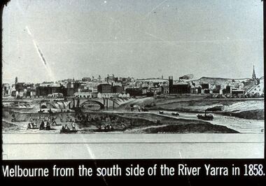
... side of the River Yarra in 1858. Markings 48 994.031 GOL:5... of the River Yarra in 1858. Markings 48 994.031 GOL:5. Used ...BHS CollectionDiggers & mining. The gold era. Melbourne from the south side of the River Yarra in 1858. Markings 48 994.031 GOL:5. Used as a teaching aid.hanimounteducation, tertiary, goldfields -
 Eltham District Historical Society Inc
Negative - Photograph, Floodwaters, Diamond Creek, Eltham, 1934
... 1934 flood of the Diamond Creek and Yarra River set... 1934 flood of the Diamond Creek and Yarra River set ...The Diamond Creek in flood near the Main Road bridge at Eltham, Victoria. The Yarra also was in flood. In early December 1934 the "Greatest flood in the history of the Yarra" occured, according to The Argus newspaper. Bridges and houses were swept away with hundreds of people left homeless across the state. The historic 1934 flood of the Diamond Creek and Yarra River set the criteria for future planning with respect to flood water rise. Noted on reverse of print - Copied by Hugh Fisher, 82 Lygon St., BrunswickThis photo forms part of a collection of photographs gathered by the Shire of Eltham for their centenary project book,"Pioneers and Painters: 100 years of the Shire of Eltham" by Alan Marshall (1971). The collection of over 500 images is held in partnership between Eltham District Historical Society and Yarra Plenty Regional Library (Eltham Library) and is now formally known as the 'The Shire of Eltham Pioneers Photograph Collection.' It is significant in being the first community sourced collection representing the places and people of the Shire's first one hundred years.Digital image 4 x 5 inch B&W Neg (2 frames on one neg) Print 9 x 15.5 cmOn reverse of print - "Copied by Hugh Fisher, 82 Lygon St., Brunswick" (for Shire of Eltham)sepp, shire of eltham pioneers photograph collection, eltham, floods, 1934 flood, diamond creek (creek), floodwater -
 Eltham District Historical Society Inc
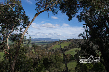
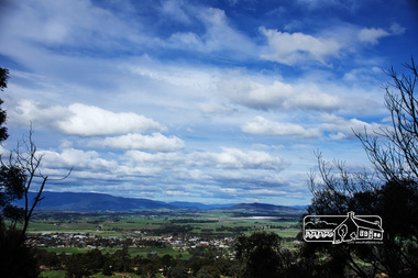
Photograph, View from Breakneck, Yarra Glen, 27 August 2016, 27/08/2016
... "Until 1865, all wheeled traffic to the Upper Yarra... melbourne "Until 1865, all wheeled traffic to the Upper Yarra ..."Until 1865, all wheeled traffic to the Upper Yarra District passed through Christmas Hills along present day Ridge and Muir roads, then followed the hazardous course of "The Breakneck" (now Breakneck Road) to the valley below. To slow the descent of wagons, logs are said to have been dragged behind. In 1865, an easier route was opened on the south side of the Yarra River, and led to the birth of Lilydale". - Christmas Hills Past and Present (Yarra Glen District Historical Society), 2004.Digital copy of colour photographfred mitchell collection, 2016, breakneck, yarra glen -
 Eltham District Historical Society Inc
Photograph, View from Breakneck, Yarra Glen, 27 August 2016, 27/08/2016
... "Until 1865, all wheeled traffic to the Upper Yarra... melbourne "Until 1865, all wheeled traffic to the Upper Yarra ..."Until 1865, all wheeled traffic to the Upper Yarra District passed through Christmas Hills along present day Ridge and Muir roads, then followed the hazardous course of "The Breakneck" (now Breakneck Road) to the valley below. To slow the descent of wagons, logs are said to have been dragged behind. In 1865, an easier route was opened on the south side of the Yarra River, and led to the birth of Lilydale". - Christmas Hills Past and Present (Yarra Glen District Historical Society), 2004.Digital copy of colour photographfred mitchell collection, 2016, breakneck, yarra glen -
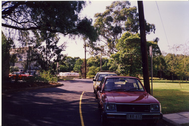
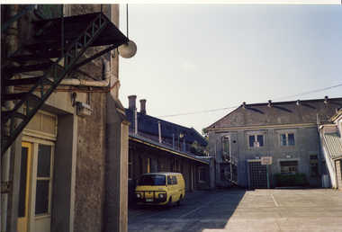
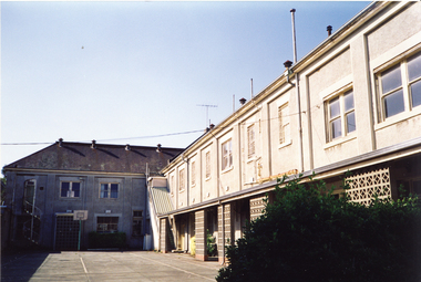
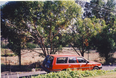
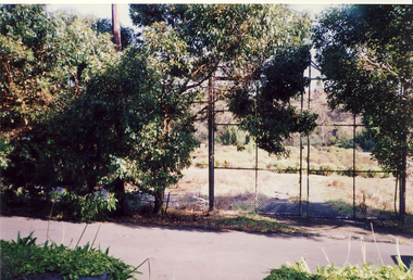
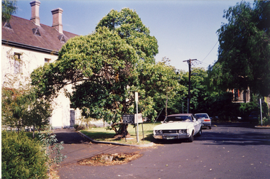
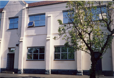
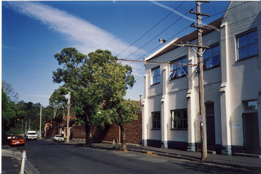
 Kew Historical Society Inc
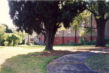
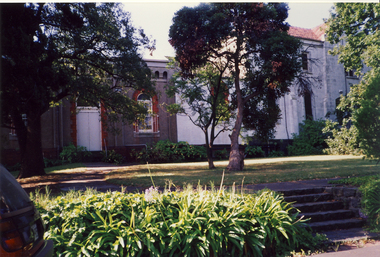
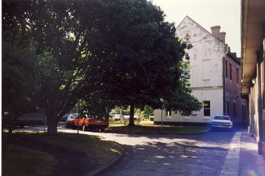
Photograph, Former Convent of the Good Shepherd, Abbotsford
... centuries on a bend of the Yarra River. In 1975 the site... on a bend of the Yarra River. In 1975 the site was purchased ...The former Convent of the Good Shepherd at Abbotsford includes ecclesiastical, residential, educational and utility buildings constructed during the late nineteenth and twentieth centuries on a bend of the Yarra River. In 1975 the site was purchased by the Victorian Government as a higher education campus. A proposed redevelopment of the site in the late 1990s led to a community-based heritage battle which resulted in 2004 in the transfer of the convent site south of St Heliers Street to the Abbotsford Convent Foundation for community use. (Source: Heritage Victoria)This photograph is part of a series taken c.1990 by the photographer Rick Lowell. It was taken before the heritage campaign to preserve the site for community use.Colour snapshot of a part or section of the Former Convent of the Good Shepherd, Abbotsfordconvent of the good shepherd, abbotsford -
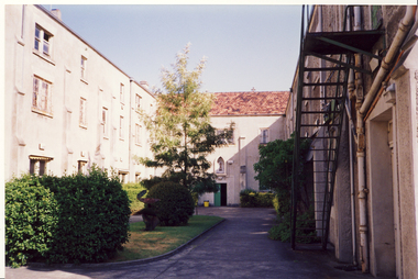
 Kew Historical Society Inc
Photograph, Former Convent of the Good Shepherd, Abbotsford
... centuries on a bend of the Yarra River. In 1975 the site... on a bend of the Yarra River. In 1975 the site was purchased ...The former Convent of the Good Shepherd at Abbotsford includes ecclesiastical, residential, educational and utility buildings constructed during the late nineteenth and twentieth centuries on a bend of the Yarra River. In 1975 the site was purchased by the Victorian Government as a higher education campus. A proposed redevelopment of the site in the late 1990s led to a community-based heritage battle which resulted in 2004 in the transfer of the convent site south of St Heliers Street to the Abbotsford Convent Foundation for community use. (Source: Heritage Victoria)This photograph is part of a series taken c.1990 by the photographer Rick Lowell. It was taken before the heritage campaign to preserve the site for community use.Colour snapshot of a part or section of the Former Convent of the Good Shepherd, Abbotsford by Rick Lovell.abbotsford convent -
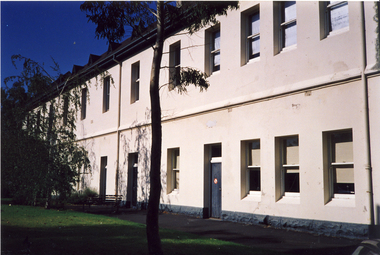
 Kew Historical Society Inc
Photograph, Former Convent of the Good Shepherd, Abbotsford
... centuries on a bend of the Yarra River. In 1975 the site... on a bend of the Yarra River. In 1975 the site was purchased ...The former Convent of the Good Shepherd at Abbotsford includes ecclesiastical, residential, educational and utility buildings constructed during the late nineteenth and twentieth centuries on a bend of the Yarra River. In 1975 the site was purchased by the Victorian Government as a higher education campus. A proposed redevelopment of the site in the late 1990s led to a community-based heritage battle which resulted in 2004 in the transfer of the convent site south of St Heliers Street to the Abbotsford Convent Foundation for community use. (Source: Heritage Victoria)This photograph is part of a series taken c.1990 by the photographer Rick Lowell. It was taken before the heritage campaign to preserve the site for community use.Colour snapshot of a part or section of the Former Convent of the Good Shepherd, Abbotsford by the photographer Rick Lowell.abbotsford convent -
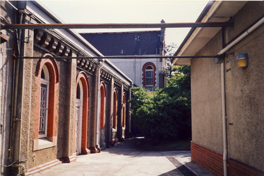
 Kew Historical Society Inc
Photograph, Former Convent of the Good Shepherd, Abbotsford
... centuries on a bend of the Yarra River. In 1975 the site... on a bend of the Yarra River. In 1975 the site was purchased ...The former Convent of the Good Shepherd at Abbotsford includes ecclesiastical, residential, educational and utility buildings constructed during the late nineteenth and twentieth centuries on a bend of the Yarra River. In 1975 the site was purchased by the Victorian Government as a higher education campus. A proposed redevelopment of the site in the late 1990s led to a community-based heritage battle which resulted in 2004 in the transfer of the convent site south of St Heliers Street to the Abbotsford Convent Foundation for community use. (Source: Heritage Victoria)This photograph is part of a series taken c.1990 by the photographer Rick Lowell. It was taken before the heritage campaign to preserve the site for community use.Colour snapshot of a part or section of the Former Convent of the Good Shepherd, Abbotsfordabbotsford convent -
 Kew Historical Society Inc
Photograph, Former Convent of the Good Shepherd, Abbotsford
... centuries on a bend of the Yarra River. In 1975 the site... on a bend of the Yarra River. In 1975 the site was purchased ...The former Convent of the Good Shepherd at Abbotsford includes ecclesiastical, residential, educational and utility buildings constructed during the late nineteenth and twentieth centuries on a bend of the Yarra River. In 1975 the site was purchased by the Victorian Government as a higher education campus. A proposed redevelopment of the site in the late 1990s led to a community-based heritage battle which resulted in 2004 in the transfer of the convent site south of St Heliers Street to the Abbotsford Convent Foundation for community use. (Source: Heritage Victoria)This photograph is part of a series taken c.1990 by the photographer Rick Lowell. It was taken before the heritage campaign to preserve the site for community use.Colour snapshot of a part or section of the Former Convent of the Good Shepherd, Abbotsfordabbotsford convent, convent of the good shepherd, abbotsford (vic.) -
 Kew Historical Society Inc
Photograph, Former Convent of the Good Shepherd, Abbotsford
... centuries on a bend of the Yarra River. In 1975 the site... on a bend of the Yarra River. In 1975 the site was purchased ...The former Convent of the Good Shepherd at Abbotsford includes ecclesiastical, residential, educational and utility buildings constructed during the late nineteenth and twentieth centuries on a bend of the Yarra River. In 1975 the site was purchased by the Victorian Government as a higher education campus. A proposed redevelopment of the site in the late 1990s led to a community-based heritage battle which resulted in 2004 in the transfer of the convent site south of St Heliers Street to the Abbotsford Convent Foundation for community use. (Source: Heritage Victoria)This photograph is part of a series taken c.1990 by the photographer Rick Lowell. It was taken before the heritage campaign to preserve the site for community use.Colour snapshot of a part or section of the Former Convent of the Good Shepherd, Abbotsfordabbotsford convent, convent of the good shepherd, abbotsford (vic.)