Showing 27615 items
matching yarra-river
-
 Marysville & District Historical Society
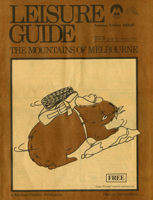
Magazine (Item) - Leisure guide, Michael Cheshire, LEISURE GUIDE THE MOUNTAINS OF MELBOURNE, 1984
A leisure guide to the mountains of Melbourne beginning in the eastern suburbs, going through the Yarra Valley and into the Great Dividing Range. This was produced by Michael Cheshire as a free publication to promote Melbourne tourism. The magazine featured Healesville, Marysville, Warburton, Eildon, Alexandra, the Upper Yarra area, and includes information on wineries in the district. It was released in the summer of 1984-1985.A leisure guide to the mountains of Melbourne beginning in the eastern suburbs, going through the Yarra Valley and into the Great Dividing Range.Summer Edition 1984-85 Featuring:/ Healesville, Marysville, Warburton, Eildon,/ Alexandra, Wineries and Upper Yarra Area.healesville, warburton, eildon, alexandra, upper yarra, marysville, victoria, australia, leisure guide, michael cheshire, blackwood holiday flats, black spur motel and caravan park, tudor lodge road house, nanda binya lodge, marysville caravan park, marysville recreation and fun park, scenic motel, the tower motel, the cumberland, cathedral restaurant, cathedral restaurant gallery, taggerty golf course, taggerty holiday units, marylyn guest house -
 Warrnambool and District Historical Society Inc.
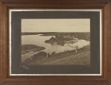
Photograph - Framed Photograph of the Islands in the Hopkins River, Jordan Studios, Warrnambool, 1911
This photograph shows the islands in the Hopkins River in 1911. This section of the river is in the Allansford area, near Jubilee Park (Hopkins River Caravan Park). It was, and still is, a picnic and fishing spot. On one of the islands is an unmarked grave which may be that of Jemima Christine Allan, the first wife of one of the first European settlers in the Allansford area, William Allan. She died in 1842. The photograph was taken by Jordan Studios so the photographer may be either Joseph Jordan, one of the best-known Warrnambool photographers of the past, or his son Arthur, also a well-credentialled photographer.This photograph is considerable historical importance, showing a section of the Hopkins River in the Warrnambool region in 1911.This is a black and white photograph in a wooden frame with a patterned edging. The photograph is inset with a gilt metal edging and enclosed in glass. The backing is wooden with a wire cord for hanging. The photograph shows the river with islands covered in vegetation. On the river are two boats, one wuih four occupants standing up in the boat and the other with two occupants. In the ccntre of the photograph is a tree stump and a dead tree.The Islands Hopkins River Warrnambool 1911 Jordan Photohopkins river, jemima allan, jordan studios -
 Melbourne Tram Museum
Newspaper, The Age, “Yarra Trams drops its Transclean contract”, 8/11/2020 12:00:00 AM
Newspaper clippings titled: “Yarra Trams drops its Transclean contract” by Timna Jacks Newspaper clipping from the Age 08/11/2020 Yarra Trams has cancelled its security contract with Transclean due to several failures of procedure and protocol after an internal audit. Transclean provided after hours security at tram depots for over 10 years and will be replaced by Spotless until the contract can be tendered. Transclean also involved in IBAC allegations of corruption with V/Line and Metro trains.trams, tramways, security, contracts, tram depot -
 Marysville & District Historical Society
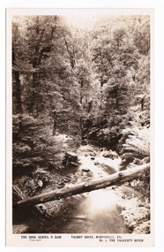
Postcard (item) - Black and white postcard, Rose Stereograph Company, Talbot Drive, Marysville, Vic. No. 3, The Taggerty River, 1913-1967
A postcard in a series produced by the Rose Stereograph Company in Victoria, Australia as a souvenir of Marysville.A black and white photograph taken along Lady Talbot Drive, Marysville, in Victoria, of the Taggerty River. Lady Talbot Drive is a 24 kilometer scenic rainforest car journey which passes a number of walks and waterfalls in the Yarra Ranges National Park. Lady Talbot Drive is named after Lady Sarah Elizabeth, the wife of Sir Reginald Talbot, who was the Governor of Victoria from 25th April, 1904 to 6th July 1908. This postcard was produced by the Rose Stereograph Company as a souvenir of Marysville.POST CARD The "Rose " Series/ De Luxe A Real Photograph/ Produced in Australia Published by the Rose Stereograph Co./ Armadale, Victoria. Dear John,/ I am writing this note in my room/ at Mt. Kitchener House before sallying forth for/ dinner. Unfortunately space does not permit/ me to tell you much, but I must let you know/ that yesterday morning (Monday), a blanket of/ snow covered the township of Marysville to a/ depth of three or four inches. Further up, near/ Keppel's Lookout, which we visited yesterday, it/ was nearly a foot deep everywhere, and it snowed/ the whole time we were walking./ Will tell you all later, your friend, Billtalbot drive, marysville, victoria, taggerty river, p. 2308, rose series postcard, postcard, souvenir, sir reginald talbot, lady sarah elizabeth talbot -
 University of Melbourne, Burnley Campus Archives
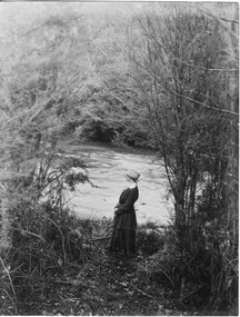
Photograph - Black and white print, River View, Unknown
Black and white photograph. Woman standing beside a river. Possibly an excursion. Photographs B91.409 to B91.417 appear to have come from the same photograph album.woman, river, excursion, rural view -
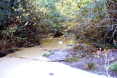
![Flooding at Chipperfield's Boathouse [East Kew], 1934](/media/collectors/550653872162f11fb04854aa/items/58cbaad5d0cec425b474bfb1/item-media/58cf6fbdd0cf9f331490feb0/item-fit-380x285.jpg) Kew Historical Society Inc
Kew Historical Society IncPhotograph, Flooding at Chipperfield's Boathouse, 1934
Living with natural processes was frequently a challenge to early European settlers and later residents of what was in the 1850s administered by the Borondara Road Board. This was compounded by the area being bounded on three sides by rivers (Yarra River, Koonung Creek and Gardiner's Creek). In 1849, the historian James Bonwick recorded that "our district [Kew] suffered considerably. Mr Wade speaks of 80 acres, out of 100 acres of his cultivated paddock, covered by water." Newspapers continued to describe major flooding in Kew in 1863, 1869, 1878, 1880, 1889, 1891, 1916 and 1934. While the construction of the Upper Yarra dam in 1957 reduced the levels of flowing downstream, local and riverine floods continue.The Kew Historical Society's pictures and map collections testify to the impact of flooding in the district. They have historical importance in documenting the extent of flooding in the district and its affects on homes, services and recreation. Numerous photographs record flooding throughout the Twentieth Century.Floods in North Kew, 1934. Chipperfield's Boathouse and the adding Moorings was located beside the Yarra River near the corner of Willsmere and Kilby Roads. The flood reached the roof of the Moorings, which can be seen in the photo.floods (kew), floods (kew) 1934, yarra river -
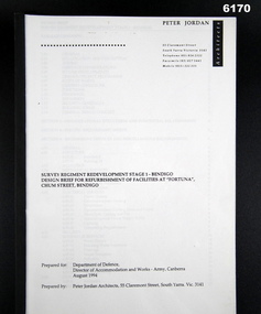 Bendigo Military Museum
Administrative record - Design Brief for Refurbishment of Facilities at "Fortuna Villa", Peter Jordan Architects, 55 Clements St, South Yarra, Vic 3141, 1994
Refurbishment Plans for building Works at Fortuna Villa, Building 23 (Ordinary Ranks Accommodation Barracks) were completed, Building 8 works were never commenced.Plastic Covered Book, A4 Pages, Building plansPeter Jordan Architects, 55 Clements St, South Yarra, Vic, 3141royal australian survey corps, rasvy, fortuna, army survey regiment, army svy regt, asr -
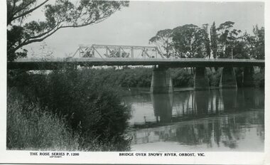 Orbost & District Historical Society
black and white photograph, Rose Stereograph Company, first half 20th century
A new bridge over the Snowy River at Orbost was opened for traffic on June 20th 1922. It was a new timber and steel girder structure, a joint Country Roads Board — Victorian Railways venture and was built and completed at a cost of £41,000 (the steel girders came from the Flinders Street viaduct reconstruction). Subsequently it was decided not to take the railway across the river, and the bridge was only ever used by road traffic. Postcards form a vital part of social and historical records for researchers. This postcard is a pictorial record of an earlier bridge across the Snowy River at Orbost.A black / white postcard photograph of a bridge over the Snowy River at Orbost.0n front - The Rose Series P1200 copyright Bridge Over Snowy River Orbost Vic.snowy-river-bridge -
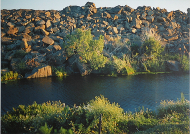
 Greensborough Historical Society
Photograph - Digital image, Marilyn Smith, Plenty River bank at Greensborough 2015; Diving platform, 16/08/2015
Steps on the Plenty River embankment in Greensborough, part of the old Plenty River pool, this is the base of the diving platform. A River bank stabilisation project along the Plenty River at Greensborough was conducted by Melbourne Water in 2015.Digital copy of colour photographplenty river, melbourne water -
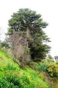
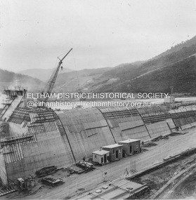
 Eltham District Historical Society Inc
Album - Photograph, J.A. McDonald, Upper Yarra Dam, Oct. 1956
Upper Yarra Dam October 1956Record of various Shire of Eltham infrastructure works undertaken during the period of 1952-1962 involving bridge and road reconstruction projects, sometimes with Eltham Shire Council Project Reference numbers quoted. It was during this period that a number of significant improvements were made to roads and new bridges constructed within the shire that remain in place as of present day (2022). In many situations, the photos provide a tangible visible record of infrastructure that existed throughout the early days of the Shire. The album was put together by or under the direction of the Shire Engineer, J.A. McDonald.infrastructure, shire of eltham, bridge construction, road construction, 1956-10, upper yarra da, upper yarra reservoir -
 Dutch Australian Heritage Centre Victoria
Book - Collection of 18th century prints, B.V.Foresta, Hollands Arcadia of de vermaarde Rivier Den Amstel - (Hollands's Arcadia or the famous Amstel river)
A soft cover reproduction on poor quality paper of a collection of illustrations first published in 1791. They were of the luxurious homes along the river Amstel owned by wealthy traders. -
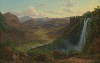 Benalla Art Gallery
Painting, Eugene VON GUERARD, The fall of the Veliono near Terni with the view up the Valley of the River Nera, 1885
Born: Vienna, Austria 1811; Arrived: Melbourne, Victoria, Australia 1852; Died: London, Middlesex England 1901RomanticismLedger Gift, 1984Rural valley and mountain landscape with two figures walking down a track beside a waterfall towards a river. Gold brushed gesso decorative edged timber frame.Recto: Signed and dated "Eug.V.Guérard / D. 85" in red oil in l.r.c of composition; Not titledpainting, landscape, river, cliff, mountain, figures, buildings, waterfall, sky, clouds -
 Brimbank City Council Art Collection
Photograph, Robert Pointon, River Rocks, 1988
Local Significance. Part of the 1989 Hunt Club Exhibition.West bank Kororoit Creek looking east. Looking directly across the creek. Foliage in the immediate foreground. Creek in the midground, Stone embankment across the river. - AR0038photograph, kororoit creek, robert, pointon -
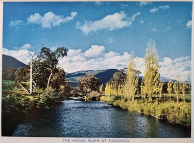 Falls Creek Historical Society
Postcard - The Kiewa River at Tawonga
These photographs were taken in and around Falls Creek by Samuel Keith Pearce and printed for him as a foldout postcard by NuColor Vue. The postcards state they were printed for S. K. Pearce Pty. Ltd of Tawonga and Mount Beauty. Samuel Keith Pearce was born on 24 June 1917 in Armadale, Victoria. By the late 1940s he owned the Mt Beauty Supermarket, Newsagency, Drapery and Hardware store at Mount Beauty and also a store at Tawonga in partnership with his brother Gordon Cathew Pearce. For some time, they operated as Pearce Brothers. In the early 1960s Keith also opened a mini mart In Falls Creek. As well as being a keen photographer and an astute businessman, Keith Pearce was a well-known identity in the Kiewa Valley, making many contributions to the development of the area over a long period. This included serving as a member of the Bright Shire Council for many years. He worked hard to promote the interests of the Upper Kiewa Valley. As a sign of recognition and appreciation for his contribution to the community, the park opposite the grocery store in Mount Beauty was named the SK Pearce Gardens in his honour. Samuel Keith Pearce died on 7 July 1994 in Mount Beauty, Victoria.This collection of postcards and images is significant because they were commissioned by a highly successful businessman in Falls Creek, Victoria.A colour image of the Kiewa River at Tawonga with mountains in the background. S. K Pearce had a business in Tawonga and established other stores at Mount Beauty and Falls Creek.falls creek, falls creek chairlifts, poma lift falls creek -
 Melbourne Tram Museum
Pamphlet, Yarra Trams, "Melbourne All Over", c2005
Pamphlet - A4 - 24 pages - printed full colour of white paper, centre stapled titled "Melbourne All Over" published by Yarra Trams c2005, after Yarra took over the whole of the Melbourne system. Covers Yarra vision for its operations, the partnership between Transfield and Transdev, accessibility, Metlink and ticketing, staff, customer service, Melbourne's cultural aspects, performance and contact addresses. Photos of 856, 3013, 3005 and 2010 Two copies held.trams, tramways, yarra trams, melbourne, transdev, transfield, metlink, melbourne, tram 856, tram 3013, tram 3005, tram 2010 -
 Melbourne Tram Museum
Sign - Adhesive label, Yarra Trams, c 2003
Adhesive Label or Signs with about the behaviour on Yarra Trams, printed on a vinyl based paper - No Smoking, No feet on seats, No fare evasion, No Alcohol, No indecent language and No forcing doors, No Animals, No Bicycles with the Yarra Trams logo in the bottom right hand corner. Sign of the type with an adhesive back.trams, tramways, yarra trams, signs, tramcars, passengers, by laws -
 Greensborough Historical Society
Photograph - Digital image, Marilyn Smith, Plenty River bank at Greensborough 2015; Rear of lower Main Street shops, 16/08/2015
Vegetation on the Plenty River embankment in Greensborough. A River bank stabilisation project along the Plenty River at Greensborough was conducted by Melbourne Water in 2015.Digital copy of colour photographplenty river, melbourne water -
 Greensborough Historical Society
Photograph - Digital image, Marilyn Smith, Plenty River bank at Greensborough 2015; Trees, 16/08/2015
Tree on bank of Plenty River in Greensborough. A River bank stabilisation project along the Plenty River at Greensborough was conducted by Melbourne Water in 2015.Digital copy of colour photographplenty river, melbourne water -
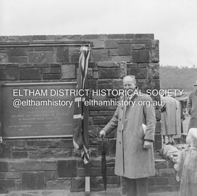 Eltham District Historical Society Inc
Negative - Photograph, J.A. McDonald, Upper Yarra Dam, 26 Nov. 1957
Sir Dallas Brooks following the formal opening of the Upper Yarra Reservoir, 26 November 1957 Upper Yarra Reservoir Opened by His Excellency The Governor of Victoria General Sir Dallas Brooks K.C.B.., K.C.M.G., K.C.V.O., D.S.O., K.St.J. On 26th November, 1957 This tablet also commemortyaes the centenary Of Melbourne's water supply system Yan Yean Reservoir 1857 Upper Yarra Reservoir 1957Record of various Shire of Eltham infrastructure works undertaken during the period of 1952-1962 involving bridge and road reconstruction projects, sometimes with Eltham Shire Council Project Reference numbers quoted. It was during this period that a number of significant improvements were made to roads and new bridges constructed within the shire that remain in place as of present day (2022). In many situations, the photos provide a tangible visible record of infrastructure that existed throughout the early days of the Shire. The album was put together by or under the direction of the Shire Engineer, J.A. McDonald.infrastructure, shire of eltham, 1957-11-26, opening ceremony, plaques, sir dallas brooks, upper yarra dam, upper yarra reservoir -
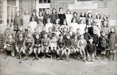
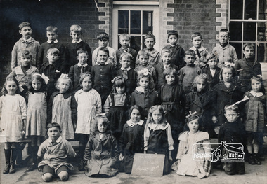 Eltham District Historical Society Inc
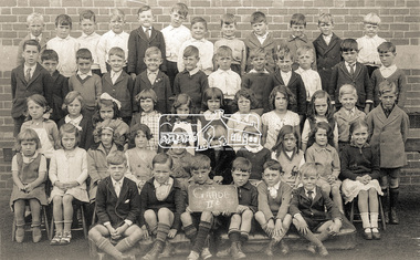
Photograph, Grade IIB, Yarra Park State School No.1406, c.1928, 1928c
Yarra Park State School No.1406 (also known as Yarra Mews) was located at 1055 Punt Road, East Melbourne. It was built 1874 - 1877. Its current use is residential appartments. It is listed in the Victorian Heritage Database. yarra park state school no. 1406, schools, yarra park, yarra mews, class photo, east melbourne, state school no. 1406 -
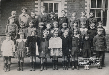 Eltham District Historical Society Inc
Photograph, Grade IIC, Yarra Park State School No.1406, c.1928, 1928c
Yarra Park State School No.1406 (also known as Yarra Mews) was located at 1055 Punt Road, East Melbourne. It was built 1874 - 1877. Its current use is residential appartments. It is listed in the Victorian Heritage Database. yarra park state school no. 1406, schools, yarra park, yarra mews, class photo, east melbourne, state school no. 1406 -
 Eltham District Historical Society Inc
Photograph, Grade 3B, Yarra Park State School No.1406, c.1928, 1928c
Yarra Park State School No.1406 (also known as Yarra Mews) was located at 1055 Punt Road, East Melbourne. It was built 1874 - 1877. Its current use is residential appartments. It is listed in the Victorian Heritage Database. yarra park state school no. 1406, schools, yarra park, yarra mews, class photo, east melbourne, state school no. 1406 -
 Eltham District Historical Society Inc
Album - Photograph, J.A. McDonald, Upper Yarra Dam, Oct. 1956
Upper Yarra Dam construction October 1956Record of various Shire of Eltham infrastructure works undertaken during the period of 1952-1962 involving bridge and road reconstruction projects, sometimes with Eltham Shire Council Project Reference numbers quoted. It was during this period that a number of significant improvements were made to roads and new bridges constructed within the shire that remain in place as of present day (2022). In many situations, the photos provide a tangible visible record of infrastructure that existed throughout the early days of the Shire. The album was put together by or under the direction of the Shire Engineer, J.A. McDonald.infrastructure, shire of eltham, bridge construction, road construction, 1956-10, upper yarra da, upper yarra reservoir -
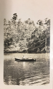 Kew Historical Society Inc
Photograph - Orlando Christian, 1924
Henry Beater Christian (1886-1962) , was a descendant of one of the earliest settler families in Kew. Employed at the Kew Asylum as a 'public servant', he was a skilled amateur photographer, photographing numerous scenes in Kew and on his travels around Victoria. The majority of his photographs date from 1916 to 1929. His finest photographs are housed in two photograph albums. Digital copy of a photograph from page 6 of the 47-page photograph album containing 261 gelatinous silver images, loaned by Diane Washfold with permission given to digitise and hold a copy in our collection. This is a photograph of the Yarra River at Kew. The focus of the view is Orlando Henry Beater Christian in his row boat. Orlando was a founder of the Willsmere Swimming Club. "Yarra Rvr /Kew"henry beater christian (1886-1962), landscape photography, kew (vic.) — yarra river, christian-washfold collection, photograph albums, orlando henry beater christian -
 Greensborough Historical Society
Photograph - Digital image, Marilyn Smith, Plenty River bank at Greensborough 2015; Low water level, 16/08/2015
Low water level Plenty River in Greensborough. A River bank stabilisation project along the Plenty River at Greensborough was conducted by Melbourne Water in 2015.Digital copy of colour photographplenty river, melbourne water -
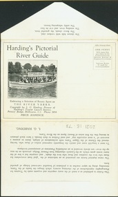 Kew Historical Society Inc
Postcard, Melbourne Ferries Pty Ltd, Harding's Pictorial River Guide
One of a number of 'real photo' and commercial postcards created by or owned by members of the Christian and Washfold families of Kew. The postcards are part of a larger collection of photographs, postcards and publications donated to the collection in May 2021.Postcard folder. Selection of ‘beauty spots’ along Yarra between Princes Bridge and Heidelberg via Studley Park. Boat advertises Harding’s Launches Studley Park & Heidelberg. Pictured boat is ‘25 Canberra’.harding's river cruises, river yarra -- tourism, harding's boat cruises, christian-washfold collection -
 Greensborough Historical Society
Slide - Photograph, John Ramsdale, Plenty River Montmorency: Slide 112, 1990s
Photograph shows a river and banks; this is the Plenty River at Montmorency.Part of the John Ramsdale collection of slides and audio visual material.Colour photograph scanned from slide.No maker's marks. No caption on slide.plenty river, montmorency -
 Kew Historical Society Inc
Photograph - Flooding of the Yarra Valley at Kew East, 1974
Flooding of the Yarra Valley, including that section of the Yarra bordering Kew and Kew East in the north and west of the municipality, was a regular occurrence. Extreme flood events of the Yarra River are recorded to have occurred in 1891, 1901, 1916, 1923 and 1934. The Municipality of Kew's response to these floods was to enact planning decisions restricting residential development in flood prone areas following the floods of 1916, 1921 and 1934. While floods continued after the development of the Upper Yarra Reservoir (construction 1948-57), the regularity and extent of these inundations diminished. During the nineteenth century, the land abutting the south side of the Yarra in Kew was devoted to dairy farming. In the twentieth century, before and after the construction of the Eastern Freeway, much of this low-lying area was used as golf courses and public parks.Late example of the capacity of the Yarra Valley at Kew to flood, even though drainage works and the Upper Yarra Reservoir had reduced their regularity.Original black and white print photograph of Hay's Paddock under floodwater on 16 May 1974. The vantage point of the photographer is Keystone Crescent looking east. Flooding was caused by overflowing water in Glass' Creek and the River Yarra. Annotation verso: "Keystone Cr looking east / 16 May 1974 11.50am"hays paddock, floods, yarra river, glass' creek -
 Eltham District Historical Society Inc
Photograph, Grade IIB, possibly Yarra Park State School No. 1406, East Melbourne, c.1930s
Unidentified school and students (not Eltham State School No. 209). Possibly Yarra Park State School No. 1406 (similar brickwork in backdrop to other photos (1928) in collection of a family that moved to Research. Yarra Park State School No.1406 (also known as Yarra Mews) was located at 1055 Punt Road, East Melbourne. It was built 1874 - 1877. Its current use is residential appartments. It is listed in the Victorian Heritage Database. Reproduction colour print of black and white printyarra park state school no. 1406, schools, yarra park, yarra mews, class photo, east melbourne, state school no. 1406 -
 University of Melbourne, Burnley Campus Archives
Photograph - Black and white print, Tidal River Excursion, 1955
See paper catalogue for list of names.Black and white photograph. Group of staff, students and children beside a truck. Cup Day 1955 at Tidal River. T. H. Kneen, Principal, and four of his children.staff, students, children, truck, cup day, 1955, tidal river, t. h. kneen, excursion