Showing 123696 items matching "main-road"
-
 Ringwood and District Historical Society
Envelope, Packet: Ringwood Neighbourhood Centre at Salvation Army, Wantirna Road; 2 leaflets 1977
2 leaflets dated Feb 1977 -
 Ringwood and District Historical Society
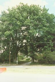
Photograph, 25 Allens Road Heathmont incl Oak Trees planted 1860 (Undated)
4 colour photographs of 25 Allens Rd, Heathmont. Weatherboard house since demolished.On back of photos: A: F Miller - 1860 Acorn from ?? B: Oak Trees planted (from) acorn from England by Frank Miller (1860) C. F. Miller 25 Allens Rd.D. ditto + "Heathmont" -
 Ringwood and District Historical Society
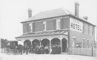
Photograph, Club Hotel, Mount Dandenong Road, (East) Ringwood in 1897
Black and white photograph.(several copies) of brick hotel with veranda. Horse and card outside and group of people standing in front of veranda.Typed below one photograph, "Club Hotel Mt. Dandenong Rd. 1897". Another adds "Incorporated in present structure". A third copy is labelled "Mrs Sweeney", possible owner. -
 Ringwood and District Historical Society
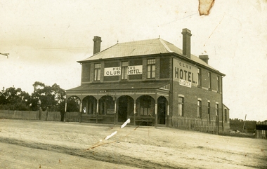
Photograph, Club Hotel, Mount Dandenong Road, (East) Ringwood, Circa 1900
Brick hotel with veranda. Sign above veranda reads "De Beer's Club Hotel" Sign on side of building reads, "Club Hotel - De Beer"(De Beer added to original Club Hotel sign - See item #2819 for earlier photo)Was H006. Photographed by "The Studio of Ringwood" -
 Ringwood and District Historical Society
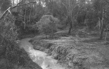
Photograph, Mullum Creek looking east from bridge in Warrandyte Road Ringwood. St. Paul's extreme left, 1972
Typed below photograph, "Mullum Creek looking east. St. Paul's extreme left, 1972". -
 Ringwood and District Historical Society
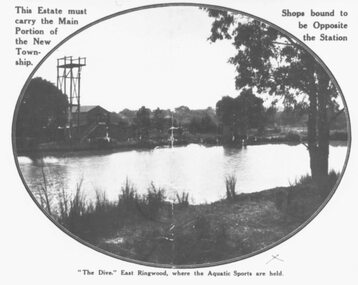
Photograph, "The Dive" East Ringwood, Knaith Road. (1924/5)
Black and white photograph. See also VC 2975 (Images RE 0026 and RE 0028) Typed directly below photograph, "'The Dive' East Ringwood, where the Aquatic Sports are held". Typed on mounting sheet below photograph, "'The Dive' East Ringwood, Knaith Rd. where the aquatic sports were held was a clayhole from a brickworks. Note diving tower. Building to left was part of the brickworks complex. Later the site of the East Ringwood Community Centre". One copy marked 1924, another "1925?" -
 Ringwood and District Historical Society
Photograph, Ringwood Golf Course, Canterbury Road. 1973
Written on backing sheet, "Golf course Canterbury Rd. 1973. Building formerly Eng. Drafting Office behind old town hall." -
 Ringwood and District Historical Society
Photograph, Ringwood Rifle Range, Jumping Creek Road, South Warrandyte, 1959
Black and white photogaph (3 copies)Written on back of photographs, "Ringwood Rifle Range, Jumping Creek, South Warrandyte, 1959". -
 Ringwood and District Historical Society
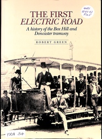
Book, The First Electric Road
History of Box Hill & Doncaster Tramways -
 Ringwood and District Historical Society
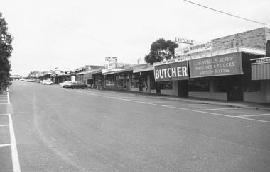
Photograph, Heathmont Shopping Centre, Canterbury Road, 1973(4 views)
Written on backing sheet, "Heathmont - 30/9/73". 4 different views. -
 Ringwood and District Historical Society
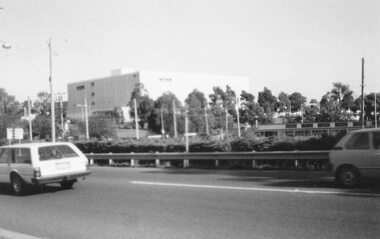
Photograph, New extra storey on Myer at Eastland, viewed from the library in Warrandyte Road, Ringwood - 1984
From library looking at new extra storey on Myers, Ringwood 1984Written on back of photograph, "From library looking at new extra storey on Myers, 1984." -
 Ringwood and District Historical Society
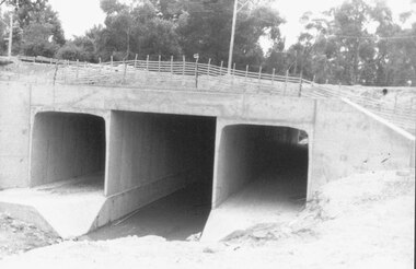
Photograph, Mullum Mullum Creek culvert installations for new bridge in Warrandyte Road, Ringwood - 19.1.1987
Culverts under new Warrandyte Rd. bridge. Mullum Mullum Creek, Ringwood 1987Written on back of photograph, "9.1.87. Culverts under new Warrandyte Rd. bridge. Mullum Mullum Creek." -
 Ringwood and District Historical Society
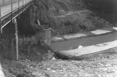
Photograph, Mullum Mullum Creek new bridge work commences. Warrandyte Road, Ringwood - 1986
Start of new bridge, Warrandyte Rd. Ringwood 1986 (2 views)Written on back of photograph, "Start of new bridge, Warrandyte Rd. 1986." -
 Ringwood and District Historical Society
Postcard, Card addressed to Miss Lena Williams, Bedford Road, Ringwood. Dated 1907
Sepia photographInscribed on back with letter to Miss Lena Williams of Ringwood- Image 10267(b) -
 Ringwood and District Historical Society
Photograph, Willsmore family house on Whitehourse Road, Ringwood - circa 1900s
Sepia photograph"Written on back of photograph" Picture taken early 1900's standing in the present car park at rear of Bank, looking North. Mr Willsmore and three sons in back garden. The Willsmores were Wales Ringwood first customers and still have connections with us. The front of the house is in the same position as present Westpac premises. The line of trees in front of house is now Maroondah Highway. Paul E.Smith - April 1985. -
 Ringwood and District Historical Society
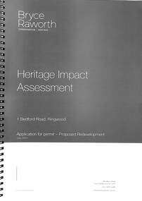
Book, Bryce Raworth, Heritage Impact Assessment - 1 Bedford Road, Ringwood, Victoria. Application for permit - Proposed Redevelopment - July 2021, 2021
A4 size wire-bound book compiled by Bryce RaworthINTRODUCTION: This heritage impact assessment (HIS) was prepared at the request of the City of Maroondah, the owner of the subject property at 1 Bedford Street (sic), Ringwood. It relates to a proposal to demolish the existing shop on the site and construct a multi-storey car park incorporating a commercial tenancy at the lower levels. It reviews the significance of the existing building on the site and the contribution it makes to the surrounding streetscapes, then comments on the heritage impacts of the proposed demolition in the context of the significance of the place and broader considerations. This office has previously provided an Historical Overview of the subject site (June 2020) and this assessment draws upon that previous research and analysis. The report has been prepared by Guy Murphy and Bryce Raworth. CONCLUSION: The proposed demolition of the former Blood Brothers Store at 1 Bedford Street (sic), Ringwood and the construction of a multi-storey car park on the enlarged site will result in the loss of some significance to the Heritage Overlay. The degree of loss is moderated by the partial intactness of the store, its modest character and the loss of its original setting, as well the proposal to implement a heritage interpretation strategy for the site. When considered in the context of the broader range of urban planning considerations and broader net community benefit, the proposed development is supported with respect to heritage impacts. -
 Ringwood and District Historical Society
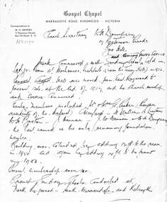
Memorabilia, Gospel Chapel Warrandyte Road , Ringwood 1927-1989, later 1 Tamar St, Ringwood
1.Hand written letter to W.H.Dempsey Secretary of the Box Hill Gospel Church with a short history of the Ringwood Church from 1917-1953. 2.Short hand written history of the Gospel Church from 1881- 1918. 3. Five letters to the Town Clerk about renting the Ringwood Town Hall for use of a Church meeting 1927 and again in 1928. Also two in March and April 1937. 4. Page of newspaper cuttings including Gospel Hall opening 5. Newspaper cutting Announcing New Church at Heathmont 21-August-1958. 6. Newpaper cutting with photo of Pastor Woodhouse with news of new child play centre. Mail 31-May-1989 7. Gospel Music Revival Centre application form. 8. Christain House 7 page typed document about the Gospel House Music Centre -
 Ringwood and District Historical Society
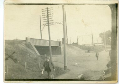
Photograph, Warrandyte Road Railway Viaduct . Ringwood 1924
Sepia photograph"Written on back of photograph" The new viaduct looking Westward toward Ringwood Railway Station. 10/5/1924 See also photograph mhc096 in NWD 02-09-06, showing costruction of viaduct in 1923. -
 Ringwood and District Historical Society
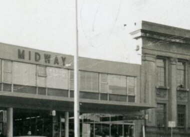
Administrative record - Documents, Midway Arcade Tenants 1956-1973, 145-147 Whitehorse Road, Ringwood
Typed carbon copies and handwritten Real Estate file records 1956 - 1973, including lists of tenants, lease arrangements, rental payments and miscellaneous receipts associated with Midway Arcade/Ringwood Investments Pty. Ltd., 517 Flinders Lane, Melbourne. -
 Ringwood and District Historical Society
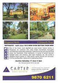
Memorabilia - Property History, Rothsaye, 2 Unsworth Road Ringwood North, Victoria
"Rothsaye" was built in 1917 by J.B. McAlpin who was a councillor in Lillydale and Ringwood and was Mayor in 1928-29.Multi pocket burgundy coloured spiral binder containing 34 pages of the property history, subdivisions, land titles and photographs of the house, compiled by Richard Carter pre-auction 17 June 2006 -
 Ringwood and District Historical Society
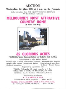
Flyer, Auction - "Heatherlie" corner Maroondah Highway and Warburton Road, Lilydale, Victoria - 1st May 1974
White bifold flyer with photographs and location. -
 Ringwood and District Historical Society
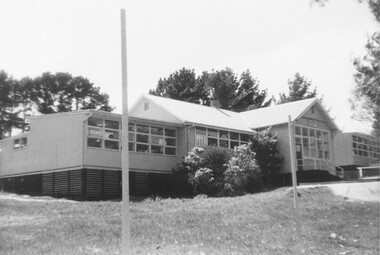
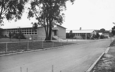
Photograph, External views of North Ringwood State School in Oban Road, including newly completed section - December 1972
Written on back of photograph, "North Ringwood State School. New section, Dec. 1972". -
 Ringwood and District Historical Society
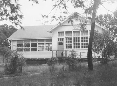
Photograph, North Ringwood State School, Oban Road - 1962
Typed below photograph, "North Ringwood S.S. Oban Rd. 1962". -
 Ringwood and District Historical Society
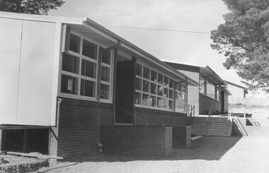
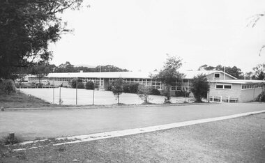
Photograph, Additions to North Ringwood State School, Oban Road, 1973
Written on backing sheet, "Additions to North Ringwood State School, 1973". -
 Ringwood and District Historical Society
Photograph, Additions to North Ringwood State School, Oban Road, 1973
Written on backing sheet, "North Ringwood State School. Additions to new section 1973". -
 Ringwood and District Historical Society
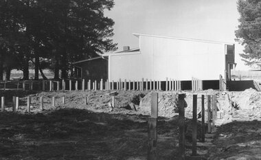
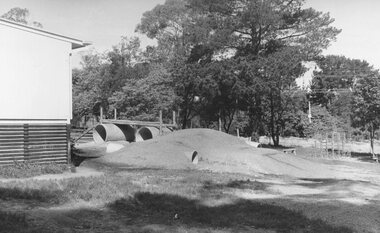
Photograph, Adventure playground additions to North Ringwood State School, Oban Road, 1973
Written on backing sheet, "North Ringwood State School Adventure playground - 1973". -
 Ringwood and District Historical Society
Photograph - Black and White, Ringwood Technical School, Heathmont Road, Heathmont - 1973. - School Buldings
B&W photos of School Buildings. Digital Only - original hard copy missingWritten on backing sheet, "Ringwood Tech. School - 1973". -
 Ringwood and District Historical Society
Photograph, Heathmont East State School, Cnr Armstrong Road & Louis Street, Heathmont - 1973
Typed below photograph, "Heathmont East State School - 1973". -
 Ringwood and District Historical Society
Photograph, 1973 view of the former site of Cass's School (1873-1894) at the corner of Everard Road and Maroondah Highway Ringwood East
Typed below photograph, "Site of Cass's School 1873-1894. Photo taken 1973. Present site of 'Lionsbrae'". -
 Ringwood and District Historical Society
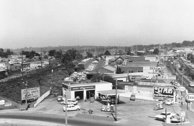
Photograph, Maroondah Highway West, Ringwood- 1969. Westward view from Ringwood Clocktower, cnr Maroondah Hwy and Wantirna Road
Black and white photographWritten on back of photograph: "Dec 1969, looking West.